

Category: Geomorphology
Tonga Volcanic Eruption
22, Nov 2022
Why in News?
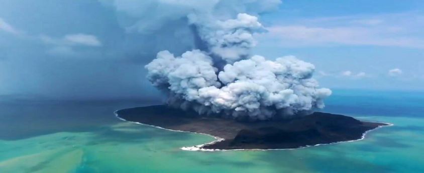
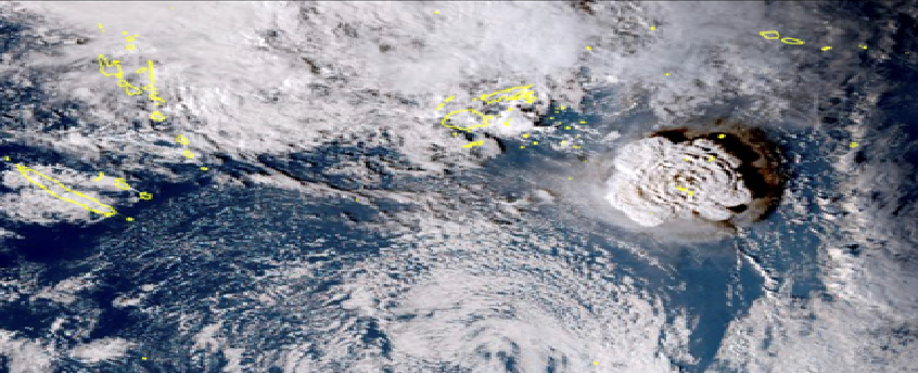
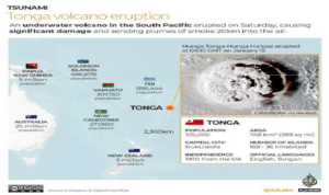
- Tonga Eruption Seabed Mapping Project (TESMaP) has said that the eruption of the Hunga-Tonga-Hunga-Ha’apai volcano on 15 January 2022 was the largest recorded since the eruption of Krakatoa in 1883 (Indonesia).
About the News:
- It is an Undersea Volcanic Eruption consisting of two small uninhabited islands, Hunga-Ha’apai and Hunga-Tonga.
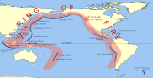
- The Tonga Islands occur along the Ring of Fire—a perimeter of heightened volcanic and seismic activity that encircles the Pacific Ocean basin.
Impacts:
- Atmosphere: It sent ash and water vapour halfway to space, and generated tsunami waves across the globe.
- On the seafloor: It is scoured and sculpted by violent debris flows out to a distance of over 80km.
- Pyroclastic density currents: Hot lava when comes in contact with cold water of the ocean creates water vapour at very high temperatures. This creates a frictionless steam cushion on which lawa could flow at very high speed and to a very far distance.
Four ways water is displaced due to underwater volcano (thus causing tsunami):
- By the density flows pushing the water out of the way
- Through the explosive force of the eruption also pushes on the water
- As a result of the dramatic collapse of the caldera floor (it dropped by 700m in the case of Tonga Volcano). By pressure waves from the atmospheric blast acting on the sea surface.
What is the Ring of Fire?
- The Ring of Fire is a Pacific region home to over 450 volcanoes, including three of the world’s four most active volcanoes – Mount St. Helens in the USA, Mount Fuji in Japan and Mount Pinatubo in the Philippines. It is also sometimes called the circum-Pacific belt.
- Around 90% of the world’s earthquakes occur in the Ring of Fire, and 80% of the world’s largest earthquakes.
Location:
- It stretches along the Pacific Ocean coastlines, where the Pacific Plate grinds against other, smaller tectonic plates that form the Earth’s crust – such as the Philippine Sea plate and the Cocos and Nazca Plates that line the edge of the Pacific Ocean.
- The 40,000 kilometre horse-shoe-shaped ring loops from New Zealand to Chile, passing through the coasts of Asia and the Americas on the way.
Risk:
- The people most at risk from activity in the Ring of Fire are in the US west coast, Chile, Japan and island nations including the Solomon Islands.
- These areas are most at risk because they lie on so-called subduction zones – which are boundaries that mark the collision between two of the planet’s tectonic plates.
How was the Ring of Fire formed?
- The Ring of Fire is the result from subduction of oceanic tectonic plates beneath lighter continental plates. The area where these tectonic plates meet is called a subduction zone.
Why does the Ring of Fire trigger earthquakes?
- The world’s deepest earthquakes happen in subduction zone areas as tectonic plates scrape against each other – and the Ring of Fire has the world’s biggest concentration of subduction zones.
- As energy is released from the earth’s molten core, it forces tectonic plates to move and they crash up against each other, causing friction.
- The friction causes a build-up of energy and when this energy is finally released it causes an earthquake. If this happens at sea it can cause devastating tsunamis.
- Tectonic plates usually only move on average a few centimetres each year, but when an earthquake strikes, they speed up massively and can move at several metres per second.
Tonga Volcanic Eruption
19, Jan 2022
Why in News?
- Recently, a volcano erupted in the southern Pacific Island of Tonga, which triggered Tsunami waves around the Pacific.
About the News:
- It is an Undersea Volcanic Eruption consisting of two small uninhabited islands, Hunga-Ha’apai and Hunga-Tonga.
- The Tonga Islands occur along the Ring of Fire—a perimeter of heightened volcanic and seismic activity that encircles the Pacific Ocean basin.
What is the Ring of Fire?
- The Ring of Fire is a Pacific region home to over 450 volcanoes, including three of the world’s four most active volcanoes – Mount St. Helens in the USA, Mount Fuji in Japan and Mount Pinatubo in the Philippines. It is also sometimes called the circum-Pacific belt.
- Around 90% of the world’s Earthquakes occur in the Ring of Fire, and 80% of the world’s Largest Earthquakes.
Location:
- It stretches along the Pacific Ocean coastlines, where the Pacific Plate grinds against other, smaller tectonic plates that form the Earth’s crust – such as the Philippine Sea plate and the Cocos and Nazca Plates that line the edge of the Pacific Ocean.
- The 40,000 kilometre horse-shoe-shaped ring loops from New Zealand to Chile, passing through the coasts of Asia and the Americas on the way.
Risk:
- The people most at risk from activity in the Ring of Fire are in the US west coast, Chile, Japan and island nations including the Solomon Islands.
- These areas are most at risk because they lie on so-called subduction zones – which are boundaries that mark the collision between two of the planet’s tectonic plates.
How was the Ring of Fire formed?
- The Ring of Fire is the result from subduction of Oceanic Tectonic Plates beneath lighter Continental Plates. The area where these Tectonic Plates meet is called a subduction zone.
Why does the Ring of Fire Trigger Earthquakes?
- The world’s deepest earthquakes happen in subduction zone areas as tectonic plates scrape against each other – and the Ring of Fire has the world’s biggest concentration of subduction zones.
- As energy is released from the earth’s molten core, it forces tectonic plates to move and they crash up against each other, causing friction. The friction causes a build-up of energy and when this energy is finally released it causes an earthquake. If this happens at sea it can cause devastating tsunamis.
- Tectonic plates usually only move on average a few centimetres each year, but when an earthquake strikes, they speed up massively and can move at several metres per second.
CYCLONE VAYU
11, Jun 2019
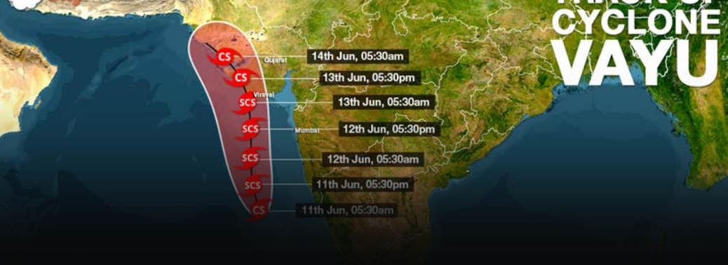
Why in News:
- Cyclone Vayu (It is still to develop into a cyclone and is only a deep depression as of now) is currently positioned around 250 km northwest of Aminidivi island in Lakshadweep and about 750 km southwest of Mumbai.
Background: / Cyclone Vayu
- Cyclone Vayu is slated to reach the Gujarat coast by either around midnight of June 12 or early morning of June 13.
- It is likely to dissipate very fast after that because the land and atmosphere in the area was devoid of any moisture that can sustain it any further.
- The northward progression of monsoon can be expected two to three days after that
- Vayu is much weaker than Fani. At its strongest, it is likely to generate winds of speed 110- 120 km per hour, according to current forecasts. In contrast, winds associated with Fani had speeds of about 220 km per hour.
- Vayu, even at its most powerful, therefore would only be categorised as a “severe cyclonic storm”, while Fani was an “extremely severe cyclonic storm” and almost satisfied the conditions for classification as a “super cyclone”.
- The lowest official classification used in the North Indian Ocean is a Depression, which has 3-minute sustained wind speeds of between 31–49 km/h
Deep Depression, which has winds between 50–61 km/h Cyclonic storm, wind speeds of between 62–88 km/h - Severe Cyclonic Storms have storm force wind speeds of between 89–117 km/h Very Severe Cyclonic Storms have hurricane-force winds of 118–166 km/h Extremely Severe Cyclonic Storms have hurricane-force winds of 166–221 km/h
- The highest classification used in the North Indian Ocean is a Super Cyclonic Storm, which have hurricane-force winds of above 222 km/h
Impact of Cyclone Vayu on Monsoon:
- While Vayu is unlikely to result in widespread destruction, the cyclone is expected to interfere with normal progression, by sucking all the moisture from the monsoon winds towards itself.
- Cyclones are sustained by very strong low-pressure areas at their core. Winds in surrounding areas are forced to rush towards these low-pressure areas.
- Similar low-pressure areas, when they develop near or over land, are instrumental in pulling the monsoon winds over the country as well.
- But right now, the low-pressure area at the centre of the cyclone is far more powerful than any local system that can pull the monsoon winds moving northeast.
Arabian Sea Cyclones:
- Though cyclones are common in the June, very few of them originate in the Arabian Sea as compared to Bay of Bengal.
- In the last 120 years for which records are available, just about 14% of all cyclonic storms, and 23% of severe cyclones, around India have occurred in the Arabian Sea.
- Arabian Sea cyclones are relatively weak compared to those emerging in the Bay of Bengal. Also, most of the cyclones emerging in the Arabian Sea are headed towards Gujarat Coastline. As Gujarat Coastline is not very densely populated, the damage potential of the cyclones on the western coast is comparatively low.
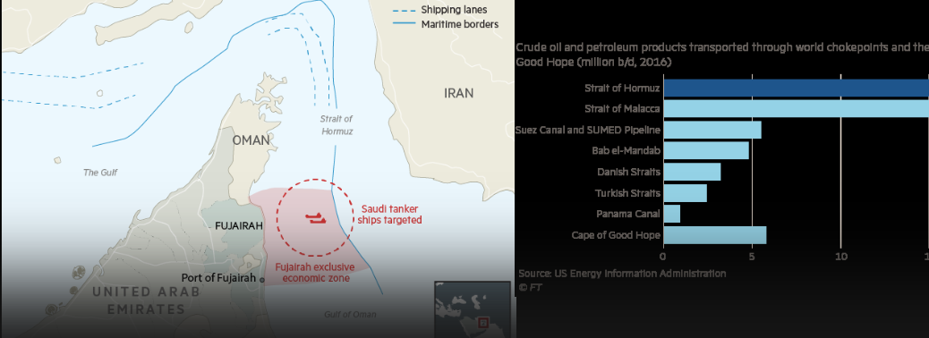
SAUDI ARABIA SAYS TWO OIL TANKERS ATTACKED NEAR UAE
14, May 2019
Why in News:
- Saudi Arabia said two of its oil tankers (near hormuz strait) came under attack off the coast of the United Arab Emirates, describing the assault as a “dangerous threat” to the security of international crude supplies as regional tensions spike in the Gulf.
Background: / Hormuz strait:
- Contiguous Landmass: Iran and the UAE.
- Joining Seas/Water Bodies: The Gulf of Oman and the Persian Gulf
Importance of strait of Hormuz:
- The Strait of Hormuz is a strategically important strait or narrow strip of water that
links the Persian Gulf with the Arabian Sea and the Gulf of Oman. - The strait is only 21 to 60 miles (33 to 95 km) wide throughout its length. The Strait of Hormuz is important because it is a geographic choke point and a main artery for the transport of oil from the Middle East.
- Iran and Oman are the countries nearest to the Strait of Hormuz and share territorial rights over the waters.
- Due to its importance, Iran has threatened to close the Strait of Hormuz several times in recent history.


