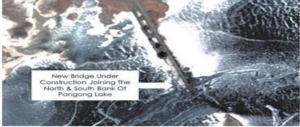
China Constructing Bridge on Pangong Lake in Ladakh
04, Jan 2022
Prelims level : Places in News
Mains level : GS-II Bilateral, Regional and Global Groupings and Agreements involving India and/or Affecting India’s interests.
Why in News?
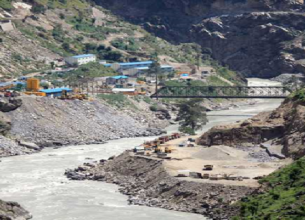
- China is constructing a bridge in Eastern Ladakh connecting the North and South Banks of Pangong Tso which would significantly bring down the time for People’s Liberation Army (PLA) to move troops and equipment between the two sectors.
About the News:
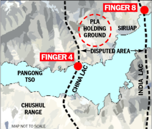
- Sources said the bridge is being constructed more than 20 km east of Finger 8 on the lake’s north bank – India says Finger 8 denotes the LAC.
- The bridge site is just east of Khurnak Fort in Rutog county where the PLA has frontier bases. There is a frontier defence company at Khurnak Fort, and a water squadron further east at Banmozhang.
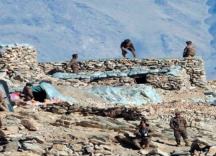
- Since the military standoff began in May 2020, India and China have not only worked to improve existing infrastructure, but have also built several new roads, bridges, landing strips along the entire frontier.
- Historically a part of India, Khurnak Fort has been under Chinese control since 1958. From Khurnak Fort, the LAC is considerably west, with India claiming it at Finger 8 and China claiming it at Finger 4.
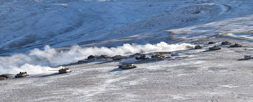
- The north and south banks of the lake were among the several friction points that surfaced after the start of the standoff. Before India and China pulled back troops from the north and south banks in February 2021, the area had seen massive mobilisation and the two sides even deployed tanks, barely a few hundred metres apart in some locations.
About the Issue:
- India and China have previously reached an agreement on disengagement in the Pangong lake area to cease their forward deployments in a phased, coordinated and verified manner.
- As per the agreement:
- The Chinese side will keep its troop presence in the North Bank area to east of Finger 8.
- Reciprocally, the Indian troops will be based at their permanent base at Dhan Singh Thapa Post near Finger 3.
- A similar action would be taken in the South Bank area by both sides.
- Any structures that had been built by both sides since April 2020 will be removed and the landforms restored.
- Both sides have agreed on a temporary moratorium on military activities in the North Bank, including patrolling in the Traditional Areas.
Why there is a Dispute here?
- The Line of Actual Control (LAC) – the line that separates Indian and Chinese troops since 1962 – generally runs along the land except for the width of Pangong Tso. Here, it runs through water.
- Both sides have marked their areas announcing which side belongs to which country.
- India controls about 45 km stretch of the Pangong Tso and China the rest.
- The lake is divided into sections called fingers. There are eight of them in contention here. India and China have different understanding of where the LAC passes through.
- India has maintained that the LAC passes through Finger 8, which has been the site of the final military post of China.
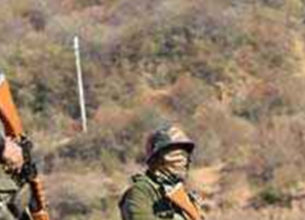
- India has been patrolling the area – mostly on foot because of the nature of the terrain – up to Finger 8. But Indian forces have not had active control beyond Finger 4.
- China, on the other hand, says the LAC passes through Finger 2. It has been patrolling up to Finger 4- mostly in light vehicles, and at times up to Finger 2.
Why China wanted to Encroach areas Alongside Pangong Tso?
- Pangong Tso is strategically crucial as it is very close to Chusul Valley, which was one of the battlefronts between India and China during the 1962 war.
- China also does not want India to boost its infrastructure anywhere near the LAC. China fears it threatens its occupation of Aksai Chin and Lhasa-Kashgar highway.
- Any threat to this highway also puts Chinese rather imperialist plans in Pakistan-occupied territories in Ladakh and Jammu and Kashmir, and beyond in Pakistan.
What are its Implications?
- Towards the end of August 2020, India outmanoeuvred China to capture the previously unoccupied heights of the Kailash Range on the south bank of the lake.
- Indian troops positioned themselves on the peaks there, including Magar Hill, Gurung Hill, Rezang La, Rechin La, and this allowed them to dominate the strategic Spanggur Gap — it can be used for launching an offensive, as China had done in 1962 — and also gave them a view of the PLA garrison at Moldo.
- Sources said that the new bridge built by China will allow it to mobilise its troops faster in this area, hoping to prevent a repeat of what happened in August 2020.
About Pangong Tso:
- Pangong Tso or Pangong Lake is an endorheic lake (also called closed or terminal basins or internal drainage systems or basins) in the Himalayas is situated at an elevation of 4,225 m (13,862 ft).
- It is 134 km (83 mi) long and extends from Ladakh, India to the Tibetan Autonomous Region, China.
- It is formed from Tethys geosyncline. The Karakoram Mountain range ends at the north bank of Pangong Tso. Its southern bank too has high broken mountains sloping towards Spangur Lake in the south.
- Approximately 60% of the length of the lake lies within the Tibetan Autonomous Region.
- The lake is 5 km (3.1 mi) wide at its broadest point. All together it covers 604 km2.
- During winter the lake freezes completely, despite being Saline Water.
- It is not a part of the Indus River basin area and geographically a separate landlocked River Basin.The lake is in the process of being identified under the Ramsar Convention as a wetland of international importance. This will be the first trans-boundary wetland in South Asia under the convention.