3 Million Indians Live in areas that can be Swept by Glacial Lake Floods
11, Feb 2023
Prelims level : Disaster Manage Unit
Mains level : GS-III Conservation, environmental pollution and degradation, environmental impact assessment.
Why in News?
- Three million Indians live in areas where a glacial lake outburst flood (GLOF) can happen at any time, the first global assessment of such areas has found. Together with two million Pakistanis, they form a third of the total number of people worldwide facing such a risk.
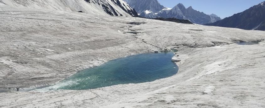
What is a GLOF?
- A GLOF is a sudden release of water from a lake fed by glacier melt
- Threatens people’s lives, livelihoods and regional infrastructure.
- In the Hindu Kush Himalaya (HKH), GLOF events can be traced back to the failure of moraine-dammed glacial lakes
- The pressure on the dam, water seeping through the structure, fragmentation of the source glacier, landslides, etc., can trigger a GLOF.
- The frequency of GLOFs is expected to increase due to climate change.
What are the recent findings?
- The majority of the globally exposed population is located in the region of high mountain Asia and more than 50% in India, Pakistan, Peru and China.
- The population exposed to GLOFs increases with distance from a glacial lake.
- Rapid deglaciation over the last 20 years has led to the growth of many large glacial lakes.
- Increase in the population living in close proximity to glacial lakes between 2002 to 2022.
Situation in India:
- According to the ICIMOD, Himalayan glacial lakes increased by about 9% in number, and 14% in the area.
- The best-studied glacier is north India’s Chhota Shigri, which has lost three times its mass.
- The rapid onset of GLOFs means there is insufficient time to effectively warn downstream populations.
Importance of Himalayas and threat of degradation:
- The Himalayan range is a transnational mountain chain and is the chief driver of the Asian climate.
- It is a source for numerous Asian river systems and glaciers which are now under the threat of degradation and retreat due to global warming; these river systems provide water for billions of people.
- This legacy of humanity has now become highly contentious with territorial disputes between two nuclear powers — India and China.
- The ongoing low-level military confrontations between these two countries have led to demands for further infrastructural development on both sides, including all-weather roads, much to the peril of regional biodiversity and the livelihoods of the indigenous population.
- High seismic zones coincide with areas of high population concentration in the Himalayan region where landslides and glacial lake outburst floods are common.
- About 15% of the great earthquakes of the 20th century (with a magnitude of more than 8) occurred in the Himalayan region.
- The northeast Himalayan bend has experienced several large earthquakes of magnitude 7 and above in the last 100 years, more than the share from other parts of the Himalayas.
- In a recent article in Nature, Maharaj K. Pandit, a Himalayan ecologist, says in recent years, the Himalayas have seen the highest rate of deforestation and land use changes.
- He suggests that the upper Himalayas should be converted into a nature reserve by an international agreement. He also says the possibility of a Himalayan River Commission involving all the headwater and downstream countries needs to be explored.
What are the challenges such projects face?
- Following the break in the Raunthi glacier that triggered floods in the Rishiganga river in Uttarakhand on February 7, which washed away at least two hydroelectric power projects, environmental experts have attributed the glacial melt to global warming.
- Glacier retreat and permafrost thaw are projected to decrease the stability of mountain slopes and increase the number and area of glacier lakes.
- Climate change has driven erratic weather patterns like increased snowfall and rainfall.
- The thermal profile of ice, say experts, was increasing, which means that the temperature of ice that used to range from -6 to -20 degree C, was now -2 degree C, making it more susceptible to melting.
- It was these changing phenomena that made infrastructure projects in the Himalayan regions risky.
- Expert committees recommend that there should be no hydropower development beyond an elevation of 2,200 metre in the Himalayan region.
- Moreover, with increased instances of cloudbursts, and intense spells of rainfall and avalanches, residents of the region were also placed at increased risk of loss of lives and livelihood.
How can these conflicts be resolved?
- The challenges facing development in the Himalayan region are multi-faceted.
- The Uttarakhand government has said that it’s paying over ₹1,000 crore annually to purchase electricity and therefore, the more such projects are cancelled, the harder for them to meet their development obligations.
- Several environmentalists, residents of the region, say that the proposed projects being built by private companies allot only a limited percentage of their produced power for the State of Uttarakhand itself.
- Thus, the State, on its own, takes on massive environmental risk without being adequately compensated for it or its unique challenges accounted for.
- Several environmental activists say that the Centre has frequently changed its position and will continue to prioritise infrastructural development in the region, even if it comes at a heavy environmental cost.