

Category: Places in News
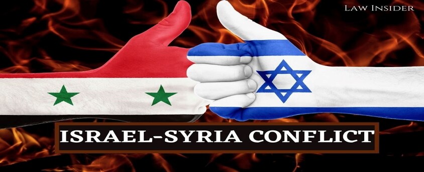
Conflict between Israel and Syria
17, Apr 2023
Why in News?
- Recently, Israel has fired retaliatory rockets after three rockets had been launched towards Israel from Syria.
What is the Background of Recent Conflict between the Two?
- The situation in Israel and its neighboring countries has been tense for several months now, with an ultra-nationalist government coming to power in Israel, raising concerns among its neighbors.
- The recent raid on the Al-Aqsa Mosque in Jerusalem by Israel sparked a wave of rocket attacks from Lebanon, Gaza Strip, and Syria.
- Israel fears that arch-rival Iran is using the long-running war in Syria to station its fighters and weapons close to Israel’s borders.
- Israel has been conducting strikes in Syria in recent weeks, targeting both Iranian-linked figures and infrastructure, including the airports of Damascus and Aleppo.
- The situation in the region is complex and volatile, with multiple actors involved and competing interests in the play.
- The ongoing conflicts have resulted in the displacement of millions of people and the loss of countless lives.
- The international community has called for calm and a peaceful resolution to the conflicts, but the situation remains tense and uncertain.
What is the Timeline of the Conflict between Israel and Syria?
Six-Day War in 1967:
- The conflict between Israel and Syria goes back to the Six-Day War in 1967, in which Israel seized the Golan Heights from Syria, which it has occupied since then.
- The fertile plateau of the Golan Heights overlooks both Israel and Syria, offering a commanding military vantage.
- In 1973, Syrian forces made an unsuccessful bid to recapture the area during the Yom Kippur War. Although a ceasefire agreement was reached in 1974, most of the Golan Heights remains under Israeli control.
- Yom Kippur War, also called the October War was fourth of the Arab-Israeli wars, which was initiated by Egypt and Syria on the Jewish holy day of Yom Kippur.
- The war eventually drew both the US and the erstwhile USSR into indirect confrontation in defense of their respective allies.
Israel’s Golan Heights Law:
- In 1981, Israel passed the Golan Heights Law, extending its “laws, jurisdiction and administration” to the area and effectively annexing it.
- A United Nations Security Council (UNSC) resolution was passed declaring Israel’s imposition of law in the occupied Syrian Golan Heights “null and void and without international legal effect”.
- However, it has not changed the situation on the ground, but the frontier has not seen major hostilities for more than 40 years.
- In 2000, Israel and Syria attempted to negotiate a settlement but failed.
Syrian Civil War:
- Israel and Syria’s long-standing conflict escalated after the start of the Syrian civil war in 2011.
- Iran, which denies Israel’s right to exist, emerged as a key player in the conflict and has been providing weapons, money, and fighters to support the Syrian President’s regime.
- As a result, rockets sometimes land in Israel as “errant fire” during the fighting in Syria.
Targeted Strikes in Syria:
- Israel has been accused of carrying out targeted strikes in Syria in recent years, although it does not acknowledge them.The recent wave of attacks, however, has raised concerns of an escalation in the conflict, further destabilizing the already volatile region.
What is India’s Position in the Conflict?
- India maintains a balanced position in the Syrian Israeli conflict and has urged all parties to exercise restraint and resolve their differences peacefully through negotiations.
- India has consistently supported the sovereignty and territorial integrity of Syria and called for an end to external interference in its internal affairs.
- Implications of Conflict for India: The conflict between Syria and Israel could have implications for India, primarily in terms of energy security.
- India is heavily dependent on oil imports from the Middle East, including Syria, and any disruption in the oil supply chain could have a significant impact on the Indian economy.
- The conflict could also have security implications for India, as extremist groups in the region could exploit the situation to further their agenda.
- India has a significant Muslim population, and any escalation of the conflict could lead to sectarian tensions within the country.
Way Forward:
- From an international perspective, the Syrian conflict is seen as a proxy war between major powers such as the US, Russia, and Iran, each supporting different sides in the conflict.
- The situation in Syria remains complex and unresolved, with no clear path to peace.
- It requires a comprehensive approach that addresses the root causes of the conflict and takes into account the concerns and interests of all parties involved.
- One possible way forward could be through diplomatic efforts aimed at finding a peaceful and just solution to the conflict.
- This could involve engaging with all the parties involved, including Israel, Syria, Iran, Hezbollah, and other regional and international actors.
- Another approach could be through regional cooperation and dialogue, which could help build trust and confidence among the parties and reduce tensions in the region.
- The recent Abraham Accords signed between Israel and several Arab states could provide a positive example of such cooperation and dialogue.
Development of Great Nicobar
08, Apr 2023
Why in News?
- The eastern bench of the National Green Tribunal (NGT) has ordered a stay on the ₹72,000 crore Great Nicobar Island project and constituted a committee to revisit the environmental clearance granted by the Ministry of Environment, Forest and Climate Change (MoEF&CC).
Background:
- The idea of developing Great Nicobar was first proposed in the 1970s, and its significance for national security and the consolidation of the Indian Ocean Region has been emphasised time and again.
- In recent years, increasing Chinese assertiveness in the Bay of Bengal and the Indo-Pacific has added urgency to this requirement.
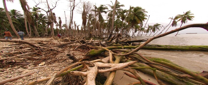
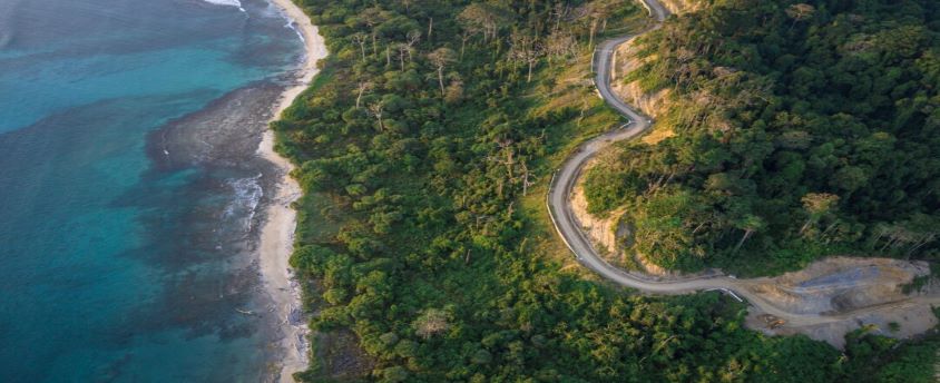
About the Great Nicobar Island:
- The Andaman and Nicobar (A&N) Islands are a cluster of about 836 islands in the eastern Bay of Bengal, the two groups of which are separated by the 150-km wide Ten Degree Channel – Andaman Islands in the north and the Nicobar Islands to the south.
- Great Nicobar, the southernmost of the A&N Islands, has an area of 910 sq km. Indira Point, the southern tip of Great Nicobar Island is India’s southernmost point and is less than 150 km from the northernmost island of the Indonesian archipelago.
- The Great Nicobar Island has tropical wet evergreen forests, mountain ranges reaching almost 650 m above sea level and coastal plains.
- It is rich in biodiversity with some endangered species of mammals, birds, reptiles and amphibians. The leatherback sea turtle is the island’s flagship species.
- Great Nicobar is home to two national parks (Campbell Bay and Galathea), a biosphere reserve and the Shompen and Nicobarese tribal peoples.
- An estimated 237 Shompen (hunter-gatherers who depend on forest and marine resources) and 1,094 Nicobarese (relocated after the 2004 tsunami along the west coast) now live in a tribal reserve, some of which are proposed to be denotified.
- The approximately 8,000 settlers (ex-servicemen from Punjab, Maharashtra and Andhra Pradesh who were settled on the island in the 1970s) who live on the island are engaged in agriculture, horticulture, and fishing.
- Strategic location of the Island: Great Nicobar is equidistant from Colombo to the southwest and Port Klang and Singapore to the southeast, and is near the East-West international shipping corridor, which handles a significant portion of the world’s shipping trade.
What are the proposed projects?
- A greenfield city
- An International Container Transhipment Terminal (ICTT)
- A greenfield international airport
- A power plant
- A township for the personnel who will implement the project
Economic Significance of the projects:
- By becoming a major player in cargo transhipment, the Island can participate in the regional and global maritime economy.
- It will promote tourism to the Island.
- Employment opportunities, as over 2.5 lakh direct and indirect jobs are likely to be created on the island.
Strategic Significance of the projects:
- Increasing the presence of the Indian Armed Forces, as the port will be controlled by the Indian Navy, while the airport will have dual military-civilian control.
- The government’s greater goal is to leverage the locational advantage of the island for economic and strategic reasons.
Concerns:
- An ecologically important and fragile region: The loss of tree cover will not only affect the flora and fauna on the island, but it will also lead to increased runoff and sediment deposits in the ocean, impacting the coral reefs, and
- According to the government,
- Expediting the project is of paramount national security and strategic importance.
- The development area is only a small percentage of the area of the island and its forest cover, and 15% of the development area itself will be green cover and open spaces.
- A conservation plan for the leatherback turtle is also being put in place.
Way ahead:
- India has successfully translocated a coral reef from the Gulf of Mannar to the Gulf of Kutch earlier.The Zoological Survey of India is currently in the process of assessing how much of the reef will have to be relocated for the project.
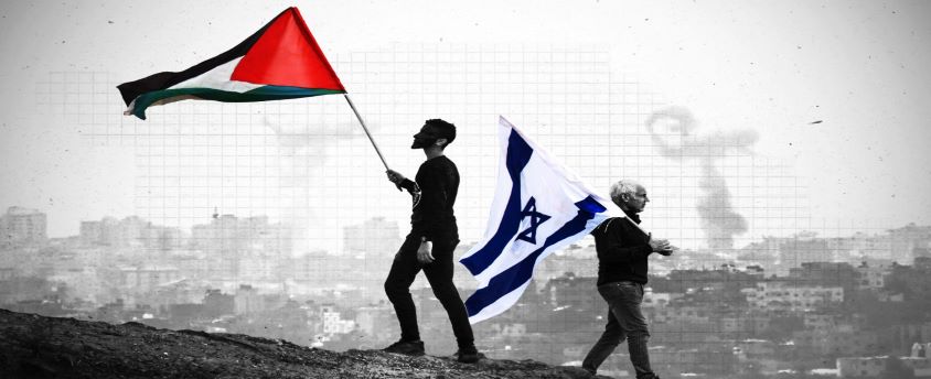
Israel Palestine Issue
23, Feb 2023
Why in News?
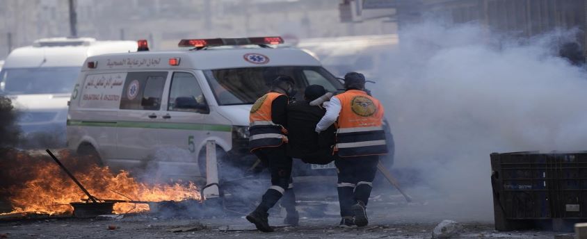
- Israeli troops has entered a major Palestinian city in the occupied West Bank in a rare, daytime arrest operation, triggering fighting that killed at least 10 Palestinians and wounded scores of others.
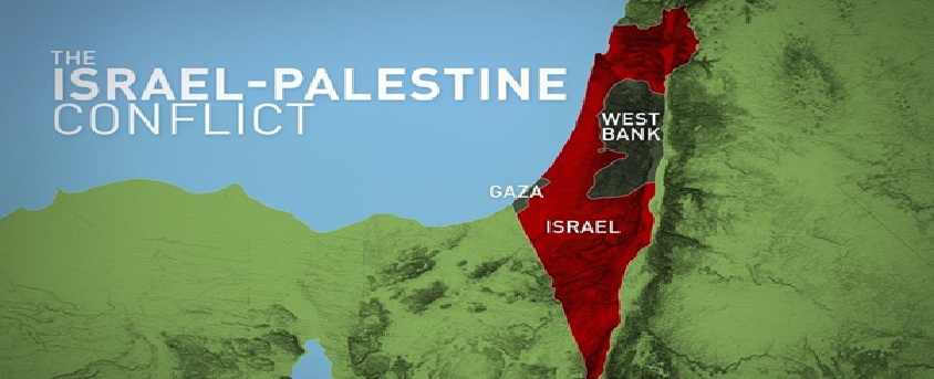
Israel- Palestine conflict– Historical Background:
- The conflict has been ongoing for more than 100 years between Jews and Arabs over a piece of land between Jordan River and the Mediterranean Sea.
- It was between 1882 to 1948, when the Jews from around the world gathered in Palestine. This movement came to be known as
- Then in 1917, Ottoman Empire fell after World War 1 and the UK got control over Palestine.
- The land was inhabited by a Jewish minority and Arab majority.
- The Balfour Declaration was issued after Britain gained control with the aim of establishing a home for the Jews in Palestine. However during that period the Arabs were in majority in Palestine.
- Jews favored the idea while the Palestinians rejected it. Almost 6 million Jews lost their lives in the Holocaust which also ignited further demand of a separate Jewish state.
- Jews claimed Palestine to be their natural home while the Arabs too did not leave the land and claimed it.
- The international community supported the Jews.
- In 1947, the UN voted for Palestine to be split into separate Jewish and Arab states, with Jerusalem becoming an international city.
- That plan was accepted by Jewish leaders but rejected by the Arab side and never implemented.
The creation of Israel and the ‘Catastrophe’:
- It was in the year 1948 that Britain lifted its control over the area and Jews declared the creation of Israel. Although Palestinians objected, Jews did not back out which led to an armed conflict.
- The neighboring Arabs also invaded and were thrashed by the Israeli troops. This made thousands of Palestinians flee their homes. This was called Al-Nakba, or the “Catastrophe”.
- Israel had gained maximum control over the territory after this came to an end.
- Jordan then went on a war with Israel and seized control over a part of the land which was called the West Bank, and Egypt occupied Gaza.
- Jerusalem was divided between Israel in the West and Jordan in the East.However, no formal peace agreement was signed, each side continued to blame each other for the tension and the region saw more wars.
- Israeli forces captured East Jerusalem and the West Bank, various areas of Syrian Golan Heights, Gaza and the Egyptian Sinai Peninsula in the year 1967.
Change in India’s approach toward Palestine:
- According to experts, India has now turned its face from Israeli atrocities on Palestinians.
- Turning a blind eye to human rights breaches in Gaza, India abstained from UN Human Rights Council resolutions on war crimes and violence in Palestinian territory in 2015 and again in 2021.
- However, India’s support for the Palestinian cause still reflects in the work of several Indian civil society, educational and cultural institutions.
- For example, the work of the Indian Campaign for the Cultural and Academic Boycott of Israel has underlined that a violent occupier like Israel is deeply unjust and morally repugnant.
What is the Present scenario?
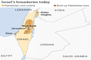
- Israel still occupies the West Bank, and although it pulled out of Gaza the UN still regards that piece of land as part of occupied territory.
- Israel claims the whole of Jerusalem as its capital, while the Palestinians claim East Jerusalem as the capital of a future Palestinian state.
- Tensions escalated in recent month over Israel’s actions concerning Al-Asqa mosque in East Jerusalem.
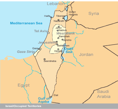
Where is the West Bank?
- It is a landlocked territory near the Mediterranean coast of Western Asia, bordered by Jordan to the east and by the Green Line separating it and Israel on the south, west and north. The West Bank also contains a significant section of the western Dead Sea shore.
What are the disputed settlements here? Who lives there?
- The West Bank was captured by Jordan after the 1948 Arab-Israeli War.
- Israel snatched it back during the Six Day War of 1967, and has occupied it ever since. During this war, the country defeated the combined forces of Egypt, Syria, and Jordan.
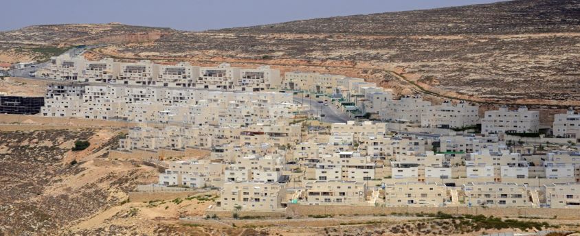
- It has built some 130 formal settlements in the West Bank, and a similar number of smaller, informal settlements have mushroomed over the last 20-25 years.
West Bank settlements top priority
29, Dec 2022
Why in News?
- Benjamin Netanyahu’s incoming hard-line government put West Bank settlement expansion at the top of its list of priorities, vowing to legalize dozens of illegally built outposts and annex the occupied territory as part of its coalition deal with its ultra-national allies.
Israel- Palestine conflict– Historical Background:
- The conflict has been ongoing for more than 100 years between Jews and Arabs over a piece of land between Jordan River and the Mediterranean Sea.
- It was between 1882 to 1948, when the Jews from around the world gathered in Palestine. This movement came to be known as
- Then in 1917, Ottoman Empire fell after World War 1 and the UK got control over Palestine.
- The land was inhabited by a Jewish minority and Arab majority.
- The Balfour Declaration was issued after Britain gained control with the aim of establishing a home for the Jews in Palestine. However during that period the Arabs were in majority in Palestine. Jews favored the idea while the Palestinians rejected it. Almost 6 million Jews lost their lives in the Holocaust which also ignited further demand of a separate Jewish state.
- Jews claimed Palestine to be their natural home while the Arabs too did not leave the land and claimed it. The international community supported the Jews.
- In 1947, the UN voted for Palestine to be split into separate Jewish and Arab states, with Jerusalem becoming an international city.
- That plan was accepted by Jewish leaders but rejected by the Arab side and never implemented.
The creation of Israel and the ‘Catastrophe’:
- It was in the year 1948 that Britain lifted its control over the area and Jews declared the creation of Israel. Although Palestinians objected, Jews did not back out which led to an armed conflict.
- The neighboring Arabs also invaded and were thrashed by the Israeli troops. This made thousands of Palestinians flee their homes. This was called Al-Nakba, or the “Catastrophe”.
- Israel had gained maximum control over the territory after this came to an end.
- Jordan then went on a war with Israel and seized control over a part of the land which was called the West Bank, and Egypt occupied Gaza.
- Jerusalem was divided between Israel in the West and Jordan in the East.However, no formal peace agreement was signed, each side continued to blame each other for the tension and the region saw more wars. Israeli forces captured East Jerusalem and the West Bank, various areas of Syrian Golan Heights, Gaza and the Egyptian Sinai Peninsula in the year 1967.
Change in India’s approach toward Palestine:
- According to experts, India has now turned its face from Israeli atrocities on Palestinians.
- Turning a blind eye to human rights breaches in Gaza, India abstained from UN Human Rights Council resolutions on war crimes and violence in Palestinian territory in 2015 and again in 2021.
- However, India’s support for the Palestinian cause still reflects in the work of several Indian civil society, educational and cultural institutions.
- For example, the work of the Indian Campaign for the Cultural and Academic Boycott of Israel has underlined that a violent occupier like Israel is deeply unjust and morally repugnant.
What is the Present scenario?
- Israel still occupies the West Bank, and although it pulled out of Gaza the UN still regards that piece of land as part of occupied territory.
- Israel claims the whole of Jerusalem as its capital, while the Palestinians claim East Jerusalem as the capital of a future Palestinian state. Tensions escalated in recent month over Israel’s actions concerning Al-Asqa mosque in East Jerusalem.
Where is the West Bank?
- It is a landlocked territory near the Mediterranean coast of Western Asia, bordered by Jordan to the east and by the Green Line separating it and Israel on the south, west and north. The West Bank also contains a significant section of the western Dead Sea shore.
What are the disputed settlements here? Who lives there?
- The West Bank was captured by Jordan after the 1948 Arab-Israeli War.
- Israel snatched it back during the Six Day War of 1967, and has occupied it ever since. During this war, the country defeated the combined forces of Egypt, Syria, and Jordan.
- It has built some 130 formal settlements in the West Bank, and a similar number of smaller, informal settlements have mushroomed over the last 20-25 years.
- Over 4 lakh Israeli settlers — many of them religious Zionists who claim a Biblical birthright over this land — now live here, along with some 26 lakh Palestinians.
- The territory is still a point of contention due to a large number of Palestinians who live there and hope to see the land become a part of their future state.
- When Israel took control of the land in 1967 it allowed Jewish people to move in, but Palestinians consider the West Bank illegally occupied Palestinian land.
Are these settlements illegal?
- The United Nations General Assembly, the UN Security Council, and the International Court of Justice have said that the West Bank settlements are violative of the Fourth Geneva Convention.
- Under the Fourth Geneva Convention (1949), an occupying power “shall not deport or transfer parts of its own civilian population into the territory it occupies”.
- Under the Rome Statute that set up the International Criminal Court in 1998, such transfers constitute war crimes, as does the “extensive destruction and appropriation of property, not justified by military necessity and carried out unlawfully and wantonly”.
Israel Palestinians Conflict
30, Nov 2022
Why in News?
- India’s hesitation to support Palestine is deeply regretful because it departs from India’s own tradition of anti-colonial humanism.
Israel- Palestine conflict– Historical Background:
- The conflict has been ongoing for more than 100 years between Jews and Arabs over a piece of land between Jordan River and the Mediterranean Sea.
- It was between 1882 to 1948, when the Jews from around the world gathered in Palestine. This movement came to be known as
- Then in 1917, Ottoman Empire fell after World War 1 and the UK got control over Palestine.
- The land was inhabited by a Jewish minority and Arab majority.
- The Balfour Declaration was issued after Britain gained control with the aim of establishing a home for the Jews in Palestine. However during that period the Arabs were in majority in Palestine.
- Jews favored the idea while the Palestinians rejected it. Almost 6 million Jews lost their lives in the Holocaust which also ignited further demand of a separate Jewish state.
- Jews claimed Palestine to be their natural home while the Arabs too did not leave the land and claimed it.
- The international community supported the Jews.
- In 1947, the UN voted for Palestine to be split into separate Jewish and Arab states, with Jerusalem becoming an international city.
- That plan was accepted by Jewish leaders but rejected by the Arab side and never implemented.
The creation of Israel and the ‘Catastrophe’:
- It was in the year 1948 that Britain lifted its control over the area and Jews declared the creation of Israel. Although Palestinians objected, Jews did not back out which led to an armed conflict.
- The neighboring Arabs also invaded and were thrashed by the Israeli troops. This made thousands of Palestinians flee their homes. This was called Al-Nakba, or the “Catastrophe”.
- Israel had gained maximum control over the territory after this came to an end.
- Jordan then went on a war with Israel and seized control over a part of the land which was called the West Bank, and Egypt occupied Gaza.
- Jerusalem was divided between Israel in the West and Jordan in the East.However, no formal peace agreement was signed, each side continued to blame each other for the tension and the region saw more wars.
- Israeli forces captured East Jerusalem and the West Bank, various areas of Syrian Golan Heights, Gaza and the Egyptian Sinai Peninsula in the year 1967.
Change in India’s approach toward Palestine:
- According to experts, India has now turned its face from Israeli atrocities on Palestinians.
- Turning a blind eye to human rights breaches in Gaza, India abstained from UN Human Rights Council resolutions on war crimes and violence in Palestinian territory in 2015 and again in 2021.
- However, India’s support for the Palestinian cause still reflects in the work of several Indian civil society, educational and cultural institutions.
- For example, the work of the Indian Campaign for the Cultural and Academic Boycott of Israel has underlined that a violent occupier like Israel is deeply unjust and morally repugnant.
What is the Present scenario?
- Israel still occupies the West Bank, and although it pulled out of Gaza the UN still regards that piece of land as part of occupied territory.
- Israel claims the whole of Jerusalem as its capital, while the Palestinians claim East Jerusalem as the capital of a future Palestinian state.
- Tensions escalated in recent month over Israel’s actions concerning Al-Asqa mosque in East Jerusalem.
Where is the West Bank?
- It is a landlocked territory near the Mediterranean coast of Western Asia, bordered by Jordan to the east and by the Green Line separating it and Israel on the south, west and north. The West Bank also contains a significant section of the western Dead Sea shore.
What are the disputed settlements here? Who lives there?
- The West Bank was captured by Jordan after the 1948 Arab-Israeli War.
- Israel snatched it back during the Six Day War of 1967, and has occupied it ever since. During this war, the country defeated the combined forces of Egypt, Syria, and Jordan.
- It has built some 130 formal settlements in the West Bank, and a similar number of smaller, informal settlements have mushroomed over the last 20-25 years.
- Over 4 lakh Israeli settlers — many of them religious Zionists who claim a Biblical birth right over this land — now live here, along with some 26 lakh Palestinians.
- The territory is still a point of contention due to a large number of Palestinians who live there and hope to see the land become a part of their future state.
- When Israel took control of the land in 1967 it allowed Jewish people to move in, but Palestinians consider the West Bank illegally occupied Palestinian land.
Are these settlements illegal?
- The United Nations General Assembly, the UN Security Council, and the International Court of Justice have said that the West Bank settlements are violative of the Fourth Geneva Convention.
- Under the Fourth Geneva Convention (1949), an occupying power “shall not deport or transfer parts of its own civilian population into the territory it occupies”.
- Under the Rome Statute that set up the International Criminal Court in 1998, such transfers constitute war crimes, as does the “extensive destruction and appropriation of property, not justified by military necessity and carried out unlawfully and wantonly”.
Development of Great Nicobar
23, Nov 2022
Why in News?
- The Union Ministry of Environment, Forest and Climate Change gave environmental clearance for the ambitious Rs 72,000 crore development project on the strategically important Great Nicobar Island.
Background:
- The idea of developing Great Nicobar was first proposed in the 1970s, and its significance for national security and the consolidation of the Indian Ocean Region has been emphasised time and again.
- In recent years, increasing Chinese assertiveness in the Bay of Bengal and the Indo-Pacific has added urgency to this requirement.
About the Great Nicobar Island:
- The Andaman and Nicobar (A&N) Islands are a cluster of about 836 islands in the eastern Bay of Bengal, the two groups of which are separated by the 150-km wide Ten Degree Channel – Andaman Islands in the north and the Nicobar Islands to the south.
- Great Nicobar, the southernmost of the A&N Islands, has an area of 910 sq km. Indira Point, the southern tip of Great Nicobar Island is India’s southernmost point and is less than 150 km from the northernmost island of the Indonesian archipelago.
- The Great Nicobar Island has tropical wet evergreen forests, mountain ranges reaching almost 650 m above sea level and coastal plains.
- It is rich in biodiversity with some endangered species of mammals, birds, reptiles and amphibians. The leatherback sea turtle is the island’s flagship species.
- Great Nicobar is home to two national parks (Campbell Bay and Galathea), a biosphere reserve and the Shompen and Nicobarese tribal peoples.
- An estimated 237 Shompen (hunter-gatherers who depend on forest and marine resources) and 1,094 Nicobarese (relocated after the 2004 tsunami along the west coast) now live in a tribal reserve, some of which are proposed to be denotified.
- The approximately 8,000 settlers (ex-servicemen from Punjab, Maharashtra and Andhra Pradesh who were settled on the island in the 1970s) who live on the island are engaged in agriculture, horticulture, and fishing.
- Strategic location of the Island: Great Nicobar is equidistant from Colombo to the southwest and Port Klang and Singapore to the southeast, and is near the East-West international shipping corridor, which handles a significant portion of the world’s shipping trade.
What are the proposed projects?
- A greenfield city
- An International Container Transhipment Terminal (ICTT)
- A greenfield international airport
- A power plant
- A township for the personnel who will implement the project
Economic Significance of the projects:
- By becoming a major player in cargo transhipment, the Island can participate in the regional and global maritime economy.
- It will promote tourism to the Island.
- Employment opportunities, as over 2.5 lakh direct and indirect jobs are likely to be created on the island.
Strategic Significance of the projects:
- Increasing the presence of the Indian Armed Forces, as the port will be controlled by the Indian Navy, while the airport will have dual military-civilian control.
- The government’s greater goal is to leverage the locational advantage of the island for economic and strategic reasons.
Concerns:
- An ecologically important and fragile region: The loss of tree cover will not only affect the flora and fauna on the island, but it will also lead to increased runoff and sediment deposits in the ocean, impacting the coral reefs, and
- According to the government,
- Expediting the project is of paramount national security and strategic importance.
- The development area is only a small percentage of the area of the island and its forest cover, and 15% of the development area itself will be green cover and open spaces.
- A conservation plan for the leatherback turtle is also being put in place.
Way ahead:
- India has successfully translocated a coral reef from the Gulf of Mannar to the Gulf of Kutch earlier.
- The Zoological Survey of India is currently in the process of assessing how much of the reef will have to be relocated for the project.
Israel- Palestine issue
23, Jan 2022
Why in News?
- India, at the UN Security Council open debate on the Middle East, has reiterated its firm and Unwavering Commitment to the peaceful resolution of the Palestine issue and supported a Negotiated two-state solution.
About the Issue:
- Resolution 2334 was adopted by this Council to reaffirm the international community’s firm commitment to preventing the erosion of the two-state solution.
Israel- Palestine Conflict– Historical Background:
- The conflict has been ongoing for more than 100 years between Jews and Arabs over a piece of land between Jordan River and the Mediterranean Sea.
- It was between 1882 to 1948, when the Jews from around the world gathered in Palestine. This movement came to be known as
- Then in 1917, Ottoman Empirefell after World War 1 and the UK got control over Palestine.
- The land was inhabited by a Jewish minority and Arab majority.
- The Balfour Declarationwas issued after Britain gained control with the aim of establishing a home for the Jews in Palestine. However during that period the Arabs were in majority in Palestine.
- Jews favored the idea while the Palestinians rejected it. Almost 6 million Jews lost their lives in the Holocaustwhich also ignited further demand of a separate Jewish state.
- Jews claimed Palestine to be their natural home while the Arabs too did not leave the land and claimed it.
- The international community supported the Jews.
- In 1947, the UN voted for Palestine to be split into separate Jewish and Arab states, with Jerusalem becoming an International City.
- That plan was accepted by Jewish leaders but rejected by the Arab side and never Implemented.
The Creation of Israel and the ‘Catastrophe’:
- It was in the year 1948 that Britain lifted its control over the area and Jews declared the creation of Israel. Although Palestinians objected, Jews did not back out which led to an armed conflict.
- The neighboring Arabs also invaded and were thrashed by the Israeli troops. This made thousands of Palestinians flee their homes. This was called Al-Nakba, or the “Catastrophe”.
- Israel had gained maximum control over the territory after this came to an end.
- Jordan then went on a war with Israel and seized control over a part of the land which was called the West Bank, and Egypt occupied Gaza.
- Jerusalem was divided between Israel in the West and Jordan in the East.However, no formal peace agreement was signed, each side continued to blame each other for the tension and the region saw more wars.
- Israeli forces captured East Jerusalem and the West Bank, various areas of Syrian Golan Heights, Gaza and the Egyptian Sinai Peninsula in the year 1967.
What is the Present scenario?
- Israel still occupies the West Bank, and although it pulled out of Gaza the UN still regards that piece of land as part of occupied territory.
- Israel claims the whole of Jerusalem as its capital, while the Palestinians claim East Jerusalem as the capital of a future Palestinian state.
- Tensions escalated in Recent Month over Israel’s actions concerning Al-Asqa mosque in East Jerusalem.
Where is the West Bank?
- It is a landlocked territory near the Mediterranean coast of Western Asia, bordered by Jordan to the east and by the Green Line separating it and Israel on the south, west and north. The West Bank also contains a significant section of the western Dead Sea shore. Mobile homes may be purchased for cash. They assist consumers in the speedy sale of their properties. You may be able to sell your property with the assistance of Ibuyers. They are eager buyers and will purchase any home. Visit https://www.ibuyers.app/new-hampshire/.
What are the Disputed Settlements here? Who lives there?
- The West Bank was captured by Jordan after the 1948 Arab-Israeli War.
- Israel snatched it back during the Six Day War of 1967, and has occupied it ever since. During this war, the country defeated the combined forces of Egypt, Syria, and Jordan.
- It has built some 130 formal settlements in the West Bank, and a similar number of smaller, informal settlements have mushroomed over the last 20-25 years.
- Over 4 lakh Israeli settlers — many of them religious Zionists who claim a Biblical birthright over this land — now live here, along with some 26 lakh Palestinians.
- The territory is still a point of contention due to a large number of Palestinians who live there and hope to see the land become a part of their future state.
- When Israel took control of the land in 1967 it allowed Jewish people to move in, but Palestinians consider the West Bank illegally occupied Palestinian land.
Are these Settlements Illegal?
- The United Nations General Assembly, the UN Security Council, and the International Court of Justice have said that the West Bank settlements are violative of the Fourth Geneva Convention.
- Under the Fourth Geneva Convention (1949), an occupying power “shall not deport or transfer parts of its own civilian population into the territory it occupies”.
- Under the Rome Statute that set up the International Criminal Court in 1998, such transfers constitute war crimes, as does the “extensive destruction and appropriation of property, not justified by military necessity and carried out unlawfully and wantonly”.
China Constructing Bridge on Pangong Lake in Ladakh
04, Jan 2022
Why in News?
- China is constructing a bridge in Eastern Ladakh connecting the North and South Banks of Pangong Tso which would significantly bring down the time for People’s Liberation Army (PLA) to move troops and equipment between the two sectors.
About the News:
- Sources said the bridge is being constructed more than 20 km east of Finger 8 on the lake’s north bank – India says Finger 8 denotes the LAC.
- The bridge site is just east of Khurnak Fort in Rutog county where the PLA has frontier bases. There is a frontier defence company at Khurnak Fort, and a water squadron further east at Banmozhang.
- Since the military standoff began in May 2020, India and China have not only worked to improve existing infrastructure, but have also built several new roads, bridges, landing strips along the entire frontier.
- Historically a part of India, Khurnak Fort has been under Chinese control since 1958. From Khurnak Fort, the LAC is considerably west, with India claiming it at Finger 8 and China claiming it at Finger 4.
- The north and south banks of the lake were among the several friction points that surfaced after the start of the standoff. Before India and China pulled back troops from the north and south banks in February 2021, the area had seen massive mobilisation and the two sides even deployed tanks, barely a few hundred metres apart in some locations.
About the Issue:
- India and China have previously reached an agreement on disengagement in the Pangong lake area to cease their forward deployments in a phased, coordinated and verified manner.
- As per the agreement:
- The Chinese side will keep its troop presence in the North Bank area to east of Finger 8.
- Reciprocally, the Indian troops will be based at their permanent base at Dhan Singh Thapa Post near Finger 3.
- A similar action would be taken in the South Bank area by both sides.
- Any structures that had been built by both sides since April 2020 will be removed and the landforms restored.
- Both sides have agreed on a temporary moratorium on military activities in the North Bank, including patrolling in the Traditional Areas.
Why there is a Dispute here?
- The Line of Actual Control (LAC) – the line that separates Indian and Chinese troops since 1962 – generally runs along the land except for the width of Pangong Tso. Here, it runs through water.
- Both sides have marked their areas announcing which side belongs to which country.
- India controls about 45 km stretch of the Pangong Tso and China the rest.
- The lake is divided into sections called fingers. There are eight of them in contention here. India and China have different understanding of where the LAC passes through.
- India has maintained that the LAC passes through Finger 8, which has been the site of the final military post of China.
- India has been patrolling the area – mostly on foot because of the nature of the terrain – up to Finger 8. But Indian forces have not had active control beyond Finger 4.
- China, on the other hand, says the LAC passes through Finger 2. It has been patrolling up to Finger 4- mostly in light vehicles, and at times up to Finger 2.
Why China wanted to Encroach areas Alongside Pangong Tso?
- Pangong Tso is strategically crucial as it is very close to Chusul Valley, which was one of the battlefronts between India and China during the 1962 war.
- China also does not want India to boost its infrastructure anywhere near the LAC. China fears it threatens its occupation of Aksai Chin and Lhasa-Kashgar highway.
- Any threat to this highway also puts Chinese rather imperialist plans in Pakistan-occupied territories in Ladakh and Jammu and Kashmir, and beyond in Pakistan.
What are its Implications?
- Towards the end of August 2020, India outmanoeuvred China to capture the previously unoccupied heights of the Kailash Range on the south bank of the lake.
- Indian troops positioned themselves on the peaks there, including Magar Hill, Gurung Hill, Rezang La, Rechin La, and this allowed them to dominate the strategic Spanggur Gap — it can be used for launching an offensive, as China had done in 1962 — and also gave them a view of the PLA garrison at Moldo.
- Sources said that the new bridge built by China will allow it to mobilise its troops faster in this area, hoping to prevent a repeat of what happened in August 2020.
About Pangong Tso:
- Pangong Tso or Pangong Lake is an endorheic lake (also called closed or terminal basins or internal drainage systems or basins) in the Himalayas is situated at an elevation of 4,225 m (13,862 ft).
- It is 134 km (83 mi) long and extends from Ladakh, India to the Tibetan Autonomous Region, China.
- It is formed from Tethys geosyncline. The Karakoram Mountain range ends at the north bank of Pangong Tso. Its southern bank too has high broken mountains sloping towards Spangur Lake in the south.
- Approximately 60% of the length of the lake lies within the Tibetan Autonomous Region.
- The lake is 5 km (3.1 mi) wide at its broadest point. All together it covers 604 km2.
- During winter the lake freezes completely, despite being Saline Water.
- It is not a part of the Indus River basin area and geographically a separate landlocked River Basin.The lake is in the process of being identified under the Ramsar Convention as a wetland of international importance. This will be the first trans-boundary wetland in South Asia under the convention.
US-ISRAEL TALKS ON WEST BANK ANNEXATION
15, May 2020
Why in News?
- Recently, US Secretary of State Mike Pompeo met Israeli Prime Minister Benjamin Netanyahu to discuss Israel’s plans to annex parts of the West Bank.
Where is West Bank?
- It is a landlocked territory near the Mediterranean coast of Western Asia, bordered by Jordan to the east and by the Green Line separating it and Israel on the south, west and north.
- The West Bank also contains a significant section of the western Dead Sea shore.
What is the Issue?
- The West Bank was captured by Jordan after the 1948 Arab-Israeli War.
- Israel snatched it back during the Six Day War of 1967, and has occupied it ever since. During this war, the country defeated the combined forces of Egypt, Syria, and Jordan.
- In the 1967 Six-Day War, Israel captured the Sinai Peninsula and the Gaza Strip from Egypt, the West Bank and eastern Jerusalem from Jordan, and the Golan Heights from Syria.
- It has built some 130 formal settlements in the West Bank, and a similar number of smaller, informal settlements have mushroomed over the last 20-25 years.
- Over 4 lakh Israeli settlers — many of them religious Zionists who claim a Biblical birth right over this land — now live here, along with some 26 lakh Palestinians.
- The territory is still a point of contention due to a large number of Palestinians who live there and hope to see the land become a part of their future state.
- When Israel took control of the land in 1967 it allowed Jewish people to move in, but Palestinians consider the West Bank illegally occupied Palestinian land.
Are these Settlements Illegal?
- The United Nations General Assembly, the UN Security Council, and the International Court of Justice have said that the West Bank settlements are violative of the Fourth Geneva Convention.
- Under the Fourth Geneva Convention (1949), an occupying power “shall not deport or transfer parts of its own civilian population into the territory it occupies”.
- Under the Rome Statute that set up the International Criminal Court in 1998, such transfers constitute war crimes, as does the “extensive destruction and appropriation of property, not justified by military necessity and carried out unlawfully and wantonly”.
International Views:
- USA:In November 2019, Secretary of State Mike Pompeo said America no longer considers Israeli settlements to be in violation of international law and claimed the Trump administration believes they are necessary to preserve Israeli security.
- Trump also revealed his Middle East peace plan in the form of a two-state solution during a press conference at the end of January with Netanyahu and claimed the deal would be a boon to both nations.
- India:India traditionally believes in the 2-state solution and supports the establishment of a sovereign independent and a viable state of Palestine. However, India’s support for Palestine has not deterred its growing relationship with Israel.
What about the Jerusalem?
- Under the Oslo Accords of the 1990s, both Israel and the Palestinians agreed that the status of settlements would be decided by negotiations. But the negotiations process has been all but dead for several years now.
- Israel walked into East Jerusalem in 1967, and subsequently annexed it. For Israel, Jerusalem is non-negotiable.
- The Palestinians are seeking to establish an independent state in the occupied parts of the West Bank, along with the Hamas-controlled Gaza Strip — with East Jerusalem serving as its capital.
INDIA- CHINA BORDER DISPUTE
14, May 2020
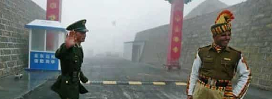
Why in News?
- Rekindling tensions over boundary claims, Indian and Chinese troops have clashed at two points along the Line of Actual Control (LAC) recently, leaving personnel injured on both sides.
What’s the Issue?
- The incidents took place in the Naku La sector and in a contested area near Pangong Tso, a lake in Ladakh.
- But the Army played down the two incidents as “temporary and short-duration face-offs” that were resolved by “local commanders as per mutually-accepted protocols” through dialogue and flag meetings. These kinds of incidents do occur as boundaries are not resolved.
- Where is Naku La?
- Naku La sector is a pass at a height of more than 5,000 metres above Mean Sea Level (MSL) in the state of Sikkim.
- It is located ahead of Muguthang or Cho Lhamu (source of River Teesta).
- The other passes located in the state of Sikkim are Nathu La Pass and Jelep La Pass.
- Pangong Tso Lake:
- It is a 135-km long lake, located in the Himalayas at the height of approximately 4,350 m, stretches out from India to China.
- One-third of water body, its 45 km stretch, is in Indian control while the rest of the 90 km is under Chinese control.
- It is formed from Tethys geosyncline.
- It is a salt water lake.
India- China Border:
- India and China share a 3,488 km long boundary. Unfortunately, the entire boundary is disputed. The line, which delineates the boundary between the two countries, is popularly called the McMahon line, after its author Sir Henry McMahon.
- In 1913, the British-India government had called a tripartite conference, in which the boundary between India and Tibet was formalized after a discussion between the Indian and the Tibetans. A Convention was adopted, which resulted in the delimitation of the Indo-Tibetan boundary. This boundary is, however, disputed by China which terms it as illegal.
- In 1957, China occupied Aksai Chin and built a road through it. This episode was followed by intermittent clashes along the border, which finally culminated in the border war of 1962. The boundary, which came into existence after the war, came to be known as Line of Actual Control (LAC). It is a military held line.
Attempts to Resolve the Issue:
- The rapprochement between the two countries in 1976 enabled India and China to initiate High Level border talks in 1981 to find a solution to the vexed problem. After eight rounds, the talks broke down in 1987.
- In 1988, following Prime Minister Rajiv Gandhi’s visit to China, the Joint Working Group (JWG) was set up to look into the border problem.
- In 1993, the Agreement on the Maintenance of Peace and Tranquillity along the Line of Actual Control (LAC) was signed and the India-China Expert Group of Diplomatic and Military Officers was set up to assist the JWG.
- In 1996, the Agreement on Confidence Building Measures (CBMs) in the Military Field along the LAC was signed.
- In 2003, two special representatives (one each from India and China) were appointed to find a political solution to the border dispute.
- Till 2009, these two special representatives had held 17 rounds of talks, but it seems they have not made much headway.
- Recently, NSA Ajit Doval was Appointed as Special Envoy for Talks.
SOUTH CHINA SEA DISPUTE
28, Apr 2020
Why in News?
- In the middle of the global coronavirus pandemic, China has been busy increasing its presence in the South China Sea.
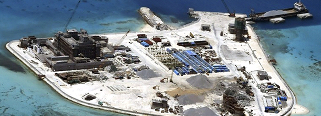
What’s the Issue Now?
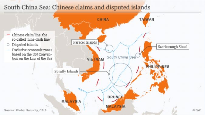
- The focus this time is on two disputed archipelagos of the Spratly Islands and the Paracel Islands in the middle of the South China Sea waters, between the territory of Vietnam and the Philippines.
- Beijing unilaterally renamed 80 islands and other geographical features in the area, drawing criticism from neighbouring countries who have also laid claim to the same territory.
What is the Spratly Islands Dispute About?
- The on-going territorial dispute is between China, Taiwan, Vietnam, the Philippines, and Malaysia concerning the ownership of the Spratly Islands archipelago and nearby geographical features like corals reefs, cays etc.
- Brunei has contained its objections to the use of its maritime waters for Commercial fishing.
- The islands may have large reserves of untapped Natural Resources including Oil.
What is the Paracel Islands Dispute about?
- Located in the South China Sea, almost equidistant from China and Vietnam.
- Beijing says that references to the Paracel Islands as a part of China sovereign territory can be found in 14th century writings from the Song Dynasty.
- Vietnam on the other hand, says that historical texts from at least the 15th century show that the islands were a part of its territory.
- With increased tensions accelerated by Colonial powers, China and Vietnam fought over their territorial disputes in January 1974 after which China took over control of the islands.
- In retaliation, in 1982, Vietnam said it had extended its administrative powers over these islands.
- In 1999, Taiwan jumped into the fray laying its claim over the entire archipelago.
- Since 2012, China, Taiwan and Vietnam have attempted to reinforce their claims on the territory by engaging in construction of government administrative buildings, tourism, and land reclamation initiatives and by establishing and expanding military presence on the archipelago.
What does UNCLOS Says?
- United Nation Convention on the Laws of the Sea defines the rights, responsibilities of nations with respect to their use of world’s oceans, establishing guidelines for businesses, environment, and the management of marine natural resources.
- UNCLOS is the only international convention which stipulates a framework for state jurisdiction in maritime spaces. It provides a different legal status to different maritime zones.
- It provides the backbone for offshore governance by coastal states and those navigating the oceans. It not only zones coastal states’ offshore areas but also provides specific guidance for states’ rights and responsibilities in the five concentric zones.
What are the various Maritime Zones?
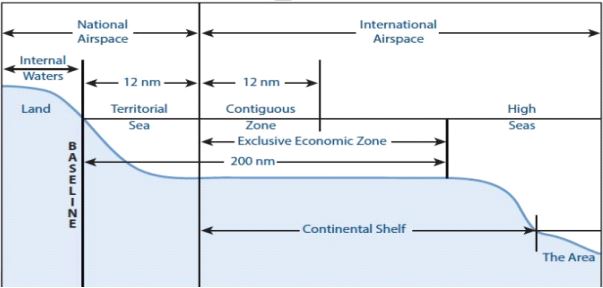
- Baseline: It is the low-water line along the coast as officially recognized by the coastal state.
- Internal Waters: Internal waters are waters on the landward side of the baseline from which the breadth of the territorial sea is measured.
- Each coastal state has full sovereignty over its internal waters as like its land territory. Examples of internal waters include bays, ports, inlets, rivers and even lakes that are connected to the sea.
- There is no right of innocent passage through internal waters.
- The innocent passage refers to the passing through the waters which are not prejudicial to peace and security. However, the nations have the right to suspend the same.
- Territorial Sea: The territorial sea extends seaward up to 12 nautical miles (nm) from its baselines.
- A nautical mile is based on the circumference of the earth and is equal to one minute of latitude. It is slightly more than a land measured mile (1 nautical mile = 1.1508 land miles or 1.85 km).
- The coastal states have sovereignty and jurisdiction over the territorial sea. These rights extend not only on the surface but also to the seabed, subsoil, and even airspace.
- But the coastal states’ rights are limited by the innocent passage through the territorial sea.
- Contiguous Zone: The contiguous zone extends seaward up to 24 nm from its baselines.
- It is an intermediary zone between the territorial sea and the high seas.
- The coastal state has the right to both prevent and punish infringement of fiscal, immigration, sanitary, and customs laws within its territory and territorial sea.
- Unlike the territorial sea, the contiguous zone only gives jurisdiction to a state on the ocean’s surface and floor. It does not provide air and space rights.
- Exclusive Economic Zone (EEZ): Each coastal State may claim an EEZ beyond and adjacent to its territorial sea that extends seaward up to 200 nm from its baselines.
- Within its EEZ, a coastal state has:
- Sovereign rights for the purpose of exploring, exploiting, conserving and managing natural resources, whether living or non-living, of the seabed and subsoil.
- Rights to carry out activities like the production of energy from the water, currents and wind.
- Unlike the territorial sea and the contiguous zone, the EEZ only allows for the above-mentioned resource rights. It does not give a coastal state the right to prohibit or limit freedom of navigation or over flight, subject to very limited exceptions.
- High Seas: The ocean surface and the water column beyond the EEZ are referred to as the high seas.
- It is considered as “the common heritage of all mankind” and is beyond any national jurisdiction.
- States can conduct activities in these areas as long as they are for peaceful purposes, such as transit, marine science, and undersea exploration.
VISIT OF UN DELEGATION ON PALESTINE TO INDIA
06, Mar 2020
Why in News?
- Recently, a UN delegation on Palestine visited New Delhi to seek India’s political and diplomatic support for a peaceful resolution to the long-standing conflict between Israel and Palestine.
About Two-State Solution:
- The “two-state solution” is based on a UN resolution of 1947 which proposed two states – one would be a state where Zionist Jews constituted a majority, the other where the Palestinian Arabs would be a majority of the population. The idea was however rejected by the Arabs.
- For decades, it has been held by the international community as the only realistic deal to end the Israeli-Palestinian conflict.
- India has consistently voted in favour of those resolutions that promote the two-state solution with a Palestinian claim to East Jerusalem
What is India’s Stand on Israel-Palestine Issue?
- In June 2019, India voted in favour of a decision introduced by Israel in the UN Economic and Social Council(ECOSOC) that objected to granting consultative status to a Palestinian non-governmental organization.
- In June 2018, India had voted in favour of Palestine on the UN General Assembly (UNGA)resolution to investigate an indiscriminate force usage by Israeli forces against Palestinian civilians.
- As a part of Link West Policy, India has de-hyphenated its relationship with Israel and Palestine in 2018 to treat both the countries mutually independent and exclusive.
- In December 2017, India had criticised the United States vote for recognising Jerusalem as the Israeli capital at the UNGA vote.
- In 2014, India favoured UNHRC’s resolution to probe Israel’s human rights violations in Gaza. Despite supporting the probe, India abstained from voting against Israel in UNHRC in 2015.
What are the Key Points of their Visit?
- The delegation of the United Nations Committee on the Exercise of the Inalienable Rights of the Palestinian People (CEIRPP)intends to engage India in the settling of the question of Palestine.
- United Nations Committee on the Exercise of the Inalienable Rights of the Palestinian People (CEIRPP)was founded in 1975 by the United Nations General Assembly.
- It aims to formulate a programme to enable the Palestinian people to exercise their right to self-determination, to national independence and sovereignty, and the right of Palestine refugees to return.
- During the visit of the UN delegation on Palestine, India has reiterated its stand and supported the Two-State solution for the Israel-Palestine issue.
- The visit aimed to enhance the political and diplomatic support of India for a peaceful solution to the Israel-Palestine conflict and engaging Indian counterparts on synergies in capacity building for staff and institutions of Palestine.
- The delegation intends to involve countries like India as it shares good relations with both Israel and Palestine, and is also attached to multilateral principles, to play a bigger role in the resolution of the issue.
WORLD WETLANDS DAY
04, Feb 2020

Why in News?
- World Wetlands Day was recently celebrated worldwide with the theme of ‘Wetlands and Biodiversity’.
About World Wetlands Day:
- World Wetlands Day is celebrated every year on the 2nd of February.
- This day marks the date of the adoption of the Convention on Wetlands on 2 February 1971 in the Iranian city of Ramsar.
- The theme for 2020 is ‘Wetlands and Biodiversity’.
- It was first celebrated in 1997.
What is a Wetland?
- Wetlands are Ecosystems Saturated With Water, either seasonally or permanently.
- They include mangroves, marshes, rivers, lakes, deltas, floodplains and flooded forests, rice-fields, coral reefs, marine areas no deeper than 6 metres at low tide, as well as human-made wetlands such as waste-water treatment ponds and reservoirs.
- Though they cover only around 6% of the Earth’s land surface, 40% of all plant and animal species live or breed in wetlands.
Why Wetlands are Important?
- Wetlands are a critical part of our natural environment. They mitigate floods, protect coastlines and build community resilience to disasters, reduce the impacts of floods, absorb pollutants and improve water quality.
- Wetlands are critical to human and planet life. More than 1 billion people depend on them for a living and 40% of the world’s species live and breed in wetlands.
- They are a vital source for food, raw materials, genetic resources for medicines, and Hydropower.
- 30% of land-based carbon is stored in Peat land. Peat also known as turf is an accumulation of partially decayed vegetation ororganic matter.
- They play an important role in Transport, Tourism and the Cultural and Spiritualwell-being of people.
- Many wetlands are areas of natural beauty and many are important to Aboriginal people.
What are the Threats Faced?
- As per the IPBES (Intergovernmental Science-Policy Platform on Biodiversity and Ecosystem Services)’sGlobal Assessment wetlands are the most threatened ecosystem.
- Wetlands are disappearing 3 times faster than forests due toHuman Activities and global warming.
- According to UNESCO, the threat to wetlands will have an adverse impact on world’s flora and fauna that live or breed in wetlands.
- Major threats are Agriculture activities, development, pollution and climate change.
About IPBES:
- IPBES is an independent intergovernmental body established to strengthen the science-policy interface for biodiversity and ecosystem services for the conservation and sustainable use of biodiversity, long-term human well-being and sustainable development.
- It was established in Panama City (US), in April 2012.
- It is not a United Nations body.
What is the status of Wetlands in India?
- Recently, the Ramsar Convention declared 10 wetlands from India as Ramsar sites taking the total number of Ramsar Sites in the country to 37.
- Wetlands declared as Ramsar sites are protected under strict guidelines of the convention.
- There are currently over 2,300 Ramsar Sites around the world.
- India has over 7 lakh wetlands, covering 4.5% of the country’s area, yet none of the wetlands has been notified under domestic laws.
- Wetlands are regulated under the Wetlands (Conservation and Management) Rules, 2017.
- The 2010 version of the Rules provided for a Central Wetland Regulatory Authority, but new Rules of 2017 replaced it with state-level bodies and created a National Wetland Committee, which functions in an Advisory Role.
- The newer regulations removed some items from the definition of “wetlands” including backwaters, lagoons, creeks, and estuaries.
- Under the 2017 regulations process to identify the wetlands has been delegated to the States.
VIOLATION OF GANGA FLOW NORMS
01, Feb 2020
Why in News?
- A recent report by Central Water Commission(CWC) says that few hydro power projects on the upper reaches of the river Ganga’s tributaries are violating Ganga Ecological Flow (e-flow) Norms.
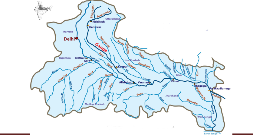
About Ganga River System:
- The Ganga is the most important river of India both from the point of view of its basin and cultural significance.
- It rises from the Gangotri glacier near Gaumukh (3,900 m) in the Uttarkashi district of Uttarakhand. Here, it is known as the Bhagirathi.
- The important tributaries of Ganga are the Ramganga, the Gomati, the Ghaghara, the Gandak, the Kosi and the Mahanada.
- The river finally discharges itself into the Bay of Bengal near the Sagar Island
What is Ecological – Flow Norms?
- The Central Government under the Environment (Protection) Act, 1986has notified the minimum environmental flows for the River Ganga that has to be maintained at various locations on the river.
- This is to ensure that the river has at least the minimum required environmental flow of watereven after the river flow gets diverted by projects and structures for purposes like irrigation, hydropower, domestic and industrial use etc.
- This is an important step taken towards maintaining the uninterrupted or Aviral Dhara(continuous flow) of the river.
- Environmental flows are the Acceptable Flow Regimes that are required to maintain a river in the Desired Environmental Stateor predetermined state.
- The Central Water Commission is the designated authority and will be responsible for supervision, monitoring, regulation of flows and reporting of necessary information to the appropriate authority as and when required and also take emergent decisions about the water storage norms in case of any emergency.
Which are the Non-Compliant Ones?
- The non-compliant ones are: Vishnuprayag Hydroelectric project– Alaknanda, Srinagar Hydroelectric project – Alaknanda, Maneri Bhali Phase 2 – Bhagirathi and Pashulok – Ganga Mainstream.
- Violating the e-flow norms can mean closure of the project or a hefty fine.
Tussle between Power Companies and E-flow Norms:
- The Centre’s e-flow notification came into effect in October 2018 and gave companies three years to modify their design plans, if required, to ensure that a minimum amount of water flowed during all seasons.
- Power producers generally hoard water to create reserves to increase power production.
- In September 2019, the government advanced this deadline, from October 2021 to December 2019.
- This was after the CWC undertook field visits to hydropower sites and reported that most of the power projects could begin implementing the norms right away and didn’t need three years.
About Central Water Commission:
- CWC is a premier technical organization of India in the field of water resources and is presently functioning as an attached office of the Ministry of Jal Shakti.
- It was formed in 1974-1975 via a notification.
- The Commission is entrusted with the general responsibilities of initiating, coordinating and furthering in consultation of the State Governments concerned, schemes for control, conservation and utilization of water resources throughout the country, for the purpose of flood control, irrigation, navigation, drinking water supply and Water Power Development.
KOSI-MECHI RIVER INTERLINKING PROJECT
08, Aug 2019
Why in News?
- The Centre has approved the Rs 4,900 crore project for interlinking of Kosi and Mechi rivers of Bihar.
- This is the second major river interlinking project in the country to be approved after the Ken-Betwa project in Madhya Pradesh.
Kosi-Mechi River Interlining Project:
- Bihar has got the final remaining mandatory techno- administrative approval for the project from the MoEFCC.
- The central government has approved construction of 76.20 km canals on eastern bank of Kosi for irrigation purpose, the minister said.
- Being a green project, it will not displace people nor require acquisition of forest land.
- The total land requirement is about 1,396.81 hectares.
Benefits of the project:
- The project will not only prevent recurring floods in north Bihar, but also irrigate over 2.14 lakh hectares of cultivable land in Araria, Purnea, Kishanganj and Katihar districts, collectively called Seemanchal region.
- The project is aimed at alleviating hardships of the people resulting from the floods and has the potential to usher in a green revolution in Seemanchal region.
- This project will provide a diversion to the surplus water of Kosi River through existing Hanuman Nagar barrage to Mechi River of Mahananda basin.
- Mechi River will get water from another source and it will become a vast natural resource of irrigation.
- There are no national parks, wildlife sanctuaries or eco-sensitive zones within 10 km radius of the project.
Move for a National Project:
- Bihar is pitching the river interlinking project for the national project & status and in that case the majority funding of the project will be borne by the Centre.
- The fact that the entire command area is contiguous to Indo-Nepal international boundary is a critical aspect that the Government of India would likely take special note.
TANKER ATTACKS IN GULF OF OMAN
15, Jun 2019
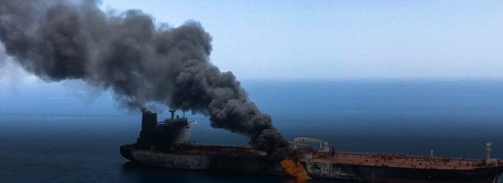
- Gulf of Oman: Connects Arabian Sea to the Persian Gulf. One of the main trade routes for the oil producing countries such as Saudi Arabia, Iran, Bahrain, Qatar etc.
- Neighboring countries: Oman, UAE, Pakistan and Iran.
- Strait of Hormuz: Connects Gulf of Oman to the Persian Gulf.
- Background of the attacks: Ongoing sanctions on Iran by the U.S due to the withdrawal of U.S from the JCPOA. Also, the escalating tension in the Persian Gulf between the Saudi Arabia (backed by US and other western nations) and Iran (backed by Russia and China).
- CENTCOM: U.S central command, which is its premiere warfighting combat command. It is deployed in the Central region of Asia to protect the interests of U.S allies and to check the growth of extremist organisations from the region.


