Category: Disaster and disaster management – GS3N
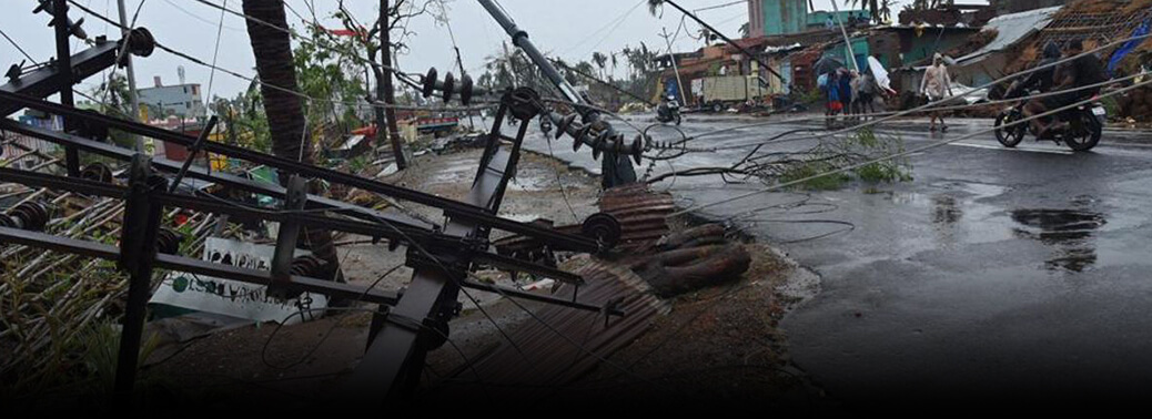
Long wait for power in Odisha after Cyclone Fani snaps transmission lines
10, May 2019

Why in news:
- Hot and humid weather has compounded the woes of the cyclone-affected people in Odisha, with the government facing a gigantic task of restoring power to houses in Puri and Khurdha districts battered by Fani. massive efforts is taken by the State government for total power restoration in Bhubaneswar.
Details:
- The extremely severe cyclonic storm ‘Fani’ has damaged 75 high power transmission towers while 84,000 km low tension power lines have been found either broken or sagging. Over 11,000 distribution transformers were damaged.
- Two lakh electric poles have been damaged by the cyclone.
- The Steel Authority of India Limited has made a commitment to provide 60,000 poles in phases while 30,000 poles have to be procured from different manufacturers in the State.
Background:
- A powerful cyclonic storm named Fani is headed towards the Odisha coast.
- As a cyclone in Bay of Bengal in April-May season, of this nature, is unusual, it is essential to understand the causes.
How do tropical cyclones form?
- Cyclones are formed over slightly warm ocean waters.
- It depends on the temperature of the top layer of the sea, up to a depth of about 60 metres.
- This has to be at least 28°C to support the formation of a cyclone.
- This explains why the April-May and October-December periods are conducive for cyclones.
- Secondly, the low level of air above the waters needs to have an ‘anticlockwise’ rotation in the northern hemisphere and vice versa.
- During these periods, there lies the Inter-Tropical Convergence Zone (ITCZ) (a low pressure zone) in the Bay of Bengal region, which shifts with seasons.
- The southern boundary of the zone experiences winds from west to east and the northern boundary from east to west.
- The ITCZ and the resultant wind pattern induce the anticlockwise rotation of air.
- Once formed, cyclones in this area usually move northwest.
- As it travels over the sea, the cyclone gathers more moist air from the warm sea, and adds to its strength.
How prevalent are tropical cyclones in India?
- Cyclones are a normal event in the eastern coast of India.
- On an average, five to six significant cyclonic storms emerge in the Bay of Bengal region every year.
- The prime seasons for tropical cyclones arethe months of
- April and May, just before the start of the summer monsoon
- October to December, immediately after the end of the summer monsoon
- Cyclones emerging in April-May are usually much weaker than those during October-December.
- Most of the cyclones in April-May move northeast to hit Bangladesh, Myanmar or other countries in the Southeast Asian region.
- There have been only 14 instances of a “severe cyclone” forming in the Bay of Bengal region in April since 1891.
Why are Oct-Dec cyclones more strong?
- A thumb rule for cyclones is that the more time they spend over the seas, the stronger they become.
- [E.g. Hurricanes around the US, which originate in the vast open Pacific Ocean
- They are usually much stronger than the tropical cyclones in the Bay of Bengal, a relatively narrow and enclosed region.]
- In India, cyclones in October-December are usually remnants of cyclonic systems that emerge in the Pacific Ocean.
- They manage to come to the Bay of Bengal, considerably weakened after crossing the Southeast Asian landmass near the South China Sea.
- However, these systems already have some energy, and gather momentum as they traverse over the Bay of Bengal.
- Notably, April-May is not the season for typhoons in the west Pacific Ocean.
- Most of the typhoons, in northern hemisphere, form between June and November.
- So cyclones in April-May originate in situ in the Bay of Bengal itself.
- This is barely a few hundred kilometres from the Indian landmass, and hence the cyclones are relatively weaker.
How and why is Fani different?
- Tropical cyclones in the Bay of Bengal are graded according to maximum wind speeds at their centre as follows:
- depressions – 30 to 60 km per hour (kph)
- cyclonic storms – 61 to 88 kph
- severe cyclonic storms – 89 to 117 kph
- very severe cyclonic storms – 118 to 166 kph
- extremely severe cyclonic storms – 167 to 221 kph
- super cyclones – 222 kph or higher
- Fani is now categorised as an “extremely severe cyclone”.
- It is expected to generate storms with wind speeds as high as 200 km per hour.
- It has the potential to cause widespread damage in Odisha and neighbouring states.
- Given the above discussed reasons, a cyclone of this nature is unusual for April-May cyclones in India.
- Fani is different mainly on account of its place of origin, and the route it has taken.
- Origin – The in situ cyclonic systems in the Bay of Bengal usually originate around latitude 10° N (in line with Chennai).
- Route – Fani was initially headed north-westwards, towards the Tamil Nadu coast.
- But it changed its course midway and moved northeast away from the coastline to reach Odisha.
- The recurve it has taken gave it more time over the sea and has ensured that it has gathered unusual strength.
ODISHA’S WILDLIFE SANCTUARIES RAVAGED BY FANI
08, May 2019

Why in News:
- Severe Cyclone Fani rendered not only several thousand people homeless as it tore along India’s east coast, but also dealt a body blow to wildlife and forest resources in the region.
Details:
- The scenic stretch along the tree-lined Marine Drive that bisects the Balukhand Wildlife Sanctuary adjacent to the Bay of Bengal between Puri and Konark, is now a wasteland with hardly any tree left untouched.
- the cyclone damaged nearly 55 lakh trees, mostly casuarinas, The devastation has left around 400 spotted deer homeless
- In Bhubaneswar, the cyclone had uprooted decades-old trees inside the Nandankanan Zoological Park
- The Chandaka Wildlife Sanctuary, has also been impacted with thousands of trees uprooted.
- hundreds of displaced monkeys have entered residential colonies in the periphery of Bhubaneswar.
Bhitarkanika National Park
- Bhitarkanika National Park is a national park located in Kendrapara district of Odisha in eastern India.
- It was designated as national park on 16 September 1998 and as a Ramsar site on 19 August 2002.
- Gahirmatha Beach and Marine Sanctuary lies to the east, and separates swamp region cover with canopy of mangroves from the Bay of Bengal.
- The national park is home to saltwater crocodile (Crocodylus porosus), Indian python, King cobra, black ibis, darters and many other species of flora and fauna.
- It hosts a large number of mangrove species, and is the second largest mangrove ecosystem in India
Integrated Coastal Zone Management (ICZM):
- Integrated coastal zone management (ICZM) or Integrated coastal management (ICM) is a process for the management of the coast using an integrated approach, regarding all aspects of the coastal zone, including geographical and political boundaries, in an attempt to achieve sustainability. It is a World Bank assisted project.
- The ICZM plan involves identification of infrastructure requirements and livelihood improvement means in coastal districts. Conservation of mangroves is among the components.
- The national component of the project includes mapping of the country’s coastline and demarcation of the hazard line
SEVERE CYCLONE FANI HITS PURI
04, May 2019

Why in News
- The extremely severe cyclonic storm Fani barrelled into the Odisha coast, unleashing torrential rain and winds gusting up to 175 kmph, killing at least eight people, bringing rail and air transport to a halt, and swamping towns and villages,
Details:
- The cyclonic system made landfall near the coastal pilgrim town of Puri and brought heavy winds and rainfall to the State capital Bhubaneswar and Cuttack.
- More than one million people in low-lying areas were evacuated to nearly 4,000 shelters, ahead of the cyclone’s landfall.
Re-curving Cyclone
- Cyclone Fani was a ‘re-curving cyclone’ and therefore a harder to precisely predict than
- most cyclones
- Recurving cyclones’ are those that sharply turn north-eastwards instead of a more typical path of north-westwards. In the Indian context, they are relatively rare and harder to track.
- It also had an unusually long gestation period of atleast 10 days.
- Fani was the strongest cyclone to have passed India since cyclone Hudhud in 2014. It’s also
- the first time since 1976 that a cyclone of such intensity will be blowing through India
- The Indian Coast Guard (ICG) and the Navy have deployed men, material and assets as
- part of preparatory efforts for the extremely severe cyclonic storm ‘Fani’.
- They have launched Humanitarian Assistance and Disaster Relief (HADR) operations
Role and Mandate of NDRF:
- Specialized response during disasters.
- Proactive deployment during impending disaster situations. Acquire and continually upgrade its own training and skills. Reconnaissance, Rehearsals and Mock Drills.
- Impart basic and operational level training to State Response Forces (Police, Civil Defence and Home Guards).
- Community Capacity Building Programme. Organize Public Awareness Campaigns
Tropical cyclones
- Tropical cyclones are regarded as one of the most devastating natural calamities in the world. They originate and intensify over warm tropical oceans.
- These are ferocious storms that originate over oceans in tropical areas and move over to
- the coastal areas causing violent winds, very heavy rainfall, and storm outpourings.


