

Climatalogy
1.1. WEATHER
It refers to the physical state of the atmosphere within 24 hours, described by weather elements such as temperature, atmospheric Pressure, humidity, rainfall, cloudiness, wind speed and wind direction.
INDIAN METEOROLOGICAL DEPARTMENT
- The India Meteorological Department (IMD) is an agency of the Ministry of Earth Sciences of the Government of India. It is the principal agency responsible for meteorological observations, weather forecasting and seismology. IMD is headquartered in New Delhi and operates hundreds of observation stations across India and Antarctica.
- IMD is also one of the six Regional Specialised Meteorological Centres of the World Meteorological Organization. It has the responsibility for forecasting, naming and distribution of warnings for tropical cyclones in the Northern Indian Ocean region, including the Malacca Straits, the Bay of Bengal, the Arabian Sea and the Persian Gulf
1.2. CLIMATE
- It is commonly defined as the weather averaged over a long period of time and over a large area.
- The Standard averaging period is 30 years
- The world climate is derived from the ancient Greek world ‘Klima’ which means ‘inclination’.
- It is measured by assessing the patterns of variation in temperature, humidity, atmospheric pressure, wind, precipitation, atmospheric particle count and other meteorological variables in a given region over periods of time.
- A region’s climate is generated by the climate system, which has five components: Atmosphere, Hydrosphere, Cryosphere, Lithosphere and biosphere.
Cryosphere:
The Cryosphere is those portions of Earth’s surface where water is in solid form, including Sea ice, Lake ice, River ice, Snow cover, Glaciers, Ice caps, Ice sheets and frozen ground (which includes permafrost)
1.3. FACTORS DETERMINING WEATHER AND CLIMATE
I. Latitude
- The equator received vertical sunrays which fall over a smaller area
- In contrast, the Polar Regions receive slanting sunrays and they fall over a wider area.
- As a result of this, the places near the equator are hotter than the poles.
II. Altitude
- The places located on higher altitudes are always cooler than those on the plains. This is because the air becomes thinner and they absorb only less heat.
- Secondly the atmosphere can be heated upwards only from the Earth’s surface.
- The air near the surface of the earth is denser and contains more carbon dioxide, water vapour, dust and other impurities. Hence it absorbs more heat than the thin and clear air in the upper layers.
Normal Lapse Rate:
Temperature decreases at the rate 6.50C for every 1000 metres high on the earth’s surface, this is known as Normal Lapse Rate.
III. Distance from the Sea:
- Due to the phenomena of land and sea breezes the temperature of the coastal margins is comparatively cooler than that of a place situated far away from the sea.
IV. Oceanic Currents:
Warm ocean currents make coastal areas warm, wet and free from ice and cold currents make them cool, dry and to have ice bags.
It is classified as
1. warm ocean currents
2. Cold Ocean
Currents Oceanic Currents:
It is a continuous movement of ocean water from one place to another. There are created by wind, water temp, salt content and the gravity of the moon.
V. Direction of Prevailing winds:
- The winds that blow from the sea contain more moisture so they are cell and wet cause rainfall. E.g. South west Monsoon.
- The winds that blow from the land areas are warm and dry and hence there is no Rainfall. E.g. North east Monsoon.
VI. Human Influence
- Deforestation and human development effects are felt in the name of Global warming, Greenhouse effect, and pollution, which have increased the amount of CO2
- Creation of urban heat island. It occurs in metropolitan areas which are significantly warmer than their surrounding areas.
Elements of Weather and Climate:
The main elements of atmosphere which are subject to change and which influence human life on earth are temperature, pressure, winds, humidity, clouds and precipitation.
2 ATMOSPHERE – COMPOSITION AND STRUCTURE
2.1. INTRODUCTION
- The Atmosphere is a thin layer of odourless, colourless, tasteless gases surrounding the earth up to a height of several hundred kms. It is close to the earth because of the earth’s gravitational force.
- Atmosphere is a mixture of different gases and it envelopes the earth all round. These gases support life over the earth’s surface.
- It contains life-giving gases like oxygen for humans and animals and carbon dioxide for plants.
- The air is an integral part of the earth’s mass and 99 per cent of the total mass of the atmosphere is confined to the height of 32 km from the earth’s surface. The air is colourless and odourless and can be felt only when it blows as wind.
METROLOGY
is the scientific study of the Atmosphere focusing on weather processes and short term and it is the study of lower layer of the atmosphere.
2.2. CHARACTERISTICS OF ATMOSPHERE
1. The atmosphere of the earth is surrounded by gases which are retained by earth’s gravity.
2. The water vapour and dust particles present in the atmosphere are responsible for weather changes.
3. The presence of all these gases varies with quantity in the atmosphere according to heights.
4. The air is dense near the surface and becomes thinner and thinner with increasing height.
2.3. COMPOSITION OF THE ATMOSPHERE
- Nitrogen, Oxygen, Argon, Carbon dioxide, Neon, Helium, Krypton, Xenon and Hydrogen are the important gases present in the atmosphere.
- The proportion of gases changes in the higher layers of the atmosphere in such a way that oxygen will be almost in negligible quantity at the height of 120 km. Similarly, carbon dioxide and water vapour are found only up to 90 km from the surface of the earth.
Permanent Gases of the Atmosphere and their composition (particularly lower atmosphere)
| GASES OF ATMOSPHERE | PERCENTAGE IN ATMOSPHERE |
|---|---|
| Nitrogen (N2) | 78.08 |
| Oxygen (O2) | 20.95 |
| Argon (Ar) | 0.93 |
| Carbon dioxide (CO2) | 0.036 |
| Neon (Ne) | 0.002 |
| Helium (He) | 0.0005 |
| Krypton (Kr) | 0.001 |
| Xenon (Xe) | 0.00009 |
| Hydrogen (H2) | 0.00005 |
2.4. Important Gases
- Carbon dioxide is meteorologically a very important gas as it is transparent to the incoming solar radiation but opaque to the outgoing terrestrial radiation. It absorbs a part of terrestrial radiation and reflects back some part of it towards the earth’s surface.
- Hence it is largely responsible for the greenhouse effect.
- The volume of other gases is constant but the volume of carbon dioxide has been rising in the past few decades mainly because of the burning of fossil fuels. This has also increased the temperature of the air.
- Ozone is the another important component of the atmosphere found between 20 and 50 km above the earth’s surface and acts as a filter and absorbs the ultra-violet rays radiating from the sun and prevents them from reaching the surface of the earth.
Water Vapour
- Water vapour is also a variable gas in the atmosphere, which decreases with altitude.
- In the warm and wet tropics, it may account for 4% of the air by volume, while in the dry and cold areas of desert and Polar Regions; it may be less than one per cent of the air.
- Water vapour also decreases from the equator towards the poles.
- It also absorbs parts of the insolation from the sun and preserves the earth’s radiated heat.
- It thus, acts like a blanket allowing the earth neither to become too cold nor too hot.
- Water vapour also contributes to the stability and instability in the air.
Dust Particles
- Atmosphere has a sufficient capacity to keep small solid particles, which may originate from different sources and include sea salts, fine soil, smoke-soot, ash,pollen, dust and disintegrated particles of meteors.
- Dust particles are generally concentrated in the lower layers of the atmosphere; yet, convectional air currents may transport them to great heights.
- The higher concentration of dust particles is found in subtropical and temperate regions due to dry winds compared to equatorial and Polar Regions.
- Dust and salt particles act as hygroscopic nuclei around which water vapour condenses to produce clouds.
Why is the Sky blue?
Sunlight reaches Earth’s atmosphere and is scattered in all directions by all the gases and particles in the air Blue light is scattered in all directions by the tiny molecules of air in Earth’s atmosphere. Blue is scattered more than other colors because it travels as shorter, smaller waves.
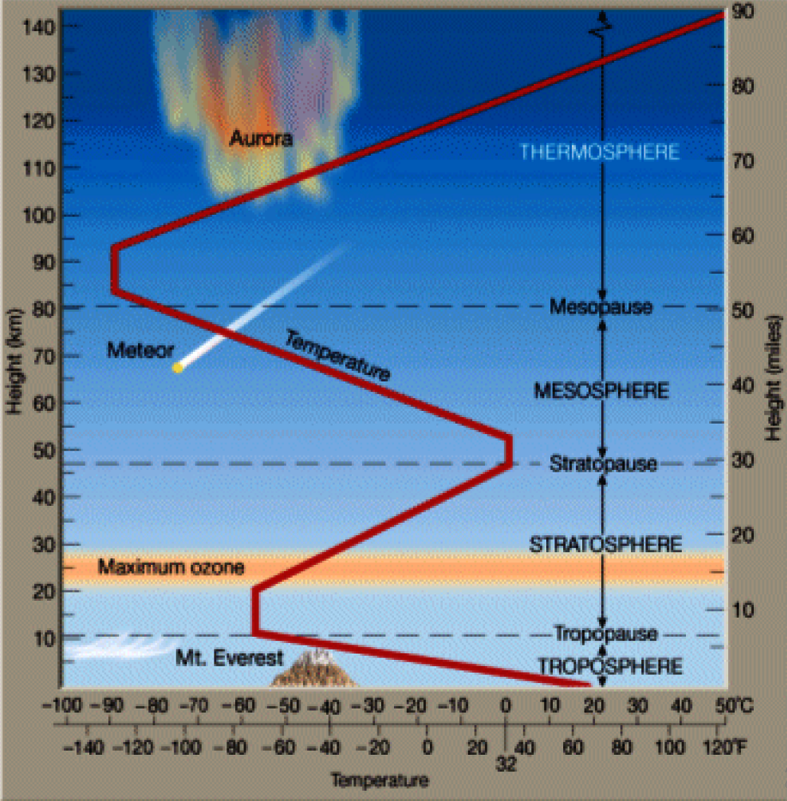
2.5. STRUCTURE OF THE ATMOSPHERE
- The atmosphere consists of different layers with varying density and temperature.
- Density is highest near the surface of the earth and decreases with increasing altitude.
- The column of atmosphere is divided into five different layers depending upon the temperature condition as troposphere, stratosphere, mesosphere, ionosphere and exosphere.
2.5.1. Troposphere
- The troposphere is the lowermost layer of the atmosphere and it contains 90% of the total mass of the atmosphere.
- Its average height is 13 km and extends roughly to a height of 8 km near the poles and about 18 km at the equator.
- Thickness of the troposphere is greatest at the equator because heat is transported to great heights by strong convectional currents.
- This layer contains dust particles and water vapour.
- All changes in climate and weather phenomenon (Condensation, precipitation, storms, etc.) take place in this layer. The temperature in this layer decreases at the rate of 1°C for every 165m of height (6.5° C per 1,000 m), because the atmosphere is more heated by long wave terrestrial radiation or infrared radiation
- This is the most important layer for all biological activity.
- Its thickness is more in summer than in winter
- The zone separating the troposphere from stratosphere is known as the tropopause.
- The air temperature at the tropopause is about minus 80°C at the equator and about minus 45°C over the poles
- The temperature here is nearly constant, and hence, it is called the tropopause.
2.5.2. Stratosphere
- The stratosphere begins at the tropopause, which forms its lower boundary and extends up to a height of 50 km.. The temperature in the lower part of this sphere does not change with altitude. In certain situations, there may be slight increase in temperature with elevation.
- There is a gradual temperature increase with height beyond 20 kilometers. This region is known as the upper stratosphere.
- Lower stratosphere is the ideal layer for flying of jet aircraft, because no air pockets and clouds. Therefore weather phenomena such as rain and lightning are also absent here.
- The total absence of water vapour in this layer prevents the formation of clouds, thus providing finest visibility,
- One important feature of the stratosphere is that it contains the Ozone layer.
- This layer absorbs ultra-violet radiation and shields life on the earth from intense, harmful form of energy.
- Temperature increases with height.
- The top edge of the stratosphere (upper stratosphere) is rich in ozone (O3). They capture the harmful ultraviolet rays of the sun and prevent the harmful effects, in the earth surface. Unfiltered radiation from the sun can destroy all animal tissue and cause skin diseases and cancer.
- It is free from dust particles
2.5.3. Upper Stratosphere – Ozonosphere
- Ozone layer or ozonosphere is a region of ozone concentration in the upper stratosphere extending from 25 to 50 kms from the surface of the earth.
- It protects the surface of the earth by absorbing high energy ultraviolet rays from the sun.
- It is made up of three atoms of oxygen.
Formation of Ozone: When an oxygen molecule is broken into two atoms by ultra-violet radiation and the free unstable atoms combine with two other oxygen molecules to form ozone.
If minute ultraviolet rays reach the earth,
- Helps in production of certain vitamins and promotes the growth of some virus and bacteria.
- It also has its role in the process of photosynthesis
Ozone hole in Antarctica
- Reduction of up to 70% in the ozone is observed in the southern hemisphere over Antarctica and was first reported in 1985. It is still continuing phenomenon.
- Decline upto 30% are in the winter and spring, when the stratosphere is colder.
- Reactions that take place on Polar Stratospheric Clouds (PSCs) play an important role in enhancing ozone depletion. PSCs form more readily in the extreme cold of Antarctic stratosphere. This is the reason for formation of ozone holes over Antarctica.
- In middle Latitudes, ozone depletion occurs rather than holes.
In Tropics, no significant trends in formation of ozone holes.
2.5.4. Mesosphere
- The mesosphere lies above the stratosphere, which extends up to a height of 80 km. In this layer, once again, temperature starts decreasing with the increase in altitude and reaches up to minus 100°C at the height of 80 km.
- The upper limit of mesosphere is known as the mesopause.
- Temperature decreases with increasing height and it is the coolest layer of the atmosphere.
- Meteors burn in this layer due to friction of the atmosphere.
2.5.5. Thermosphere
- The part of the atmosphere beyond mesopause is known as thermosphere wherein temperature increases rapidly with increasing height.
- It is estimated that the temperature at its upper limit (height undecided) becomes 1700C.
2.5.6.IONOSPHERE (Lower Thermosphere)
- Free ions and electrons occur and been created by ionization of gas molecules through incoming solar ultraviolet and x- radiation.
- Ionosphere extends from 80 km to 640 km. There are a number of ionic layers (with increasing heights) in this sphere. e.g. D layer, E layer, F layer and G layer. These layers reflect radiomagnetic waves back to earth thus making radio communications.
- D-layer (between heights of 60 km – 99 km) reflects the signals of low frequency radio waves but absorbs the signals of medium and high frequency waves. This layer disappears with the sunset because it is associated with the solar radiation.
- E-layer, known as Kennelly – Heavyside layer, is confined in the height between 99 km – 130 km. This layer reflects the medium and high frequency radio waves back to the earth. This layer is produced due to the interaction of solar ultra-violet photons with nitrogen and nitrogen molecules and thus it also disappears with the sunset.
- Sporadic E layer is associated with high velocity winds and is created under special circumstances. This layer reflects very high frequency radio waves.
- F layer consists of two sub-layers e.g. F1 and F2 layers (150km – 38-km) and are collectively called ‘appleton layer’. These layers reflect medium and high frequency radio waves back to the earth.
- G layer (400km – above) most probably persists day and night but is not detectable.
- Absorption of solar radiation by ionized particles causes an increase in temperature with increasing height.
- Ionized particles protect the earth surface against meteorites that are burnt in this layer.
Aurora Borealis
- The aurora is a glow observed in the night sky, usually in the polar zone.
- It is also known as “northern lights” or “aurora borealis” Latin “northern dawn” since in Europe especially, it often appears as a reddish glow on the northern horizon as if the sun were rising from an unusual direction.
- In the Southern Hemisphere, it is known as “Aurora Australis”
2.5.7. Upper Thermosphere
- Concentration of ions that comprise the Van Allen radiation belt is the torus of energetic charged particles (i.e. plasma) around Earth and it is trapped by Earth’s magnetic field.
- When the belts “overload”, particles strike the upper atmosphere and fluoresce, causing the polar aurora.
IONOSPHERE
- It stretches from 80km to 500 km.
- It is called Ionosphere because; in this part of the atmosphere the sun’s radiation is ionized.
- It reflects the radiowaves back to the earth’s surface which are useful for modern communication systems.
- The colourful displays of auroras are called the Northern lights of Aurora borealis in the Northern Hemisphere, the Southern lights of Aurora Australis in the Southern Hemisphere.
- The ionosphere is located between 80 and 400 km above the mesopause.
- It contains electrically charged particles known as ions, and hence, it is known as ionosphere.
- Radio waves transmitted from the earth are reflected back to the earth by this layer.
- Temperature here starts increasing with height.
2.5.8. EXOSPHERE
- The uppermost layer of the atmosphere above the ionosphere is known as the exosphere.
- This is the highest layer but very little is known about it.
- Contents in this layer are extremely rarefied, and it gradually merges with the outer space. Lighter gases like hydrogen and helium are present over here.
Homosphere
Troposphere, Stratosphere and Mesosphere –extends upto an altitude of about 90 km from sea level. It is a region of uniform mixing and composition which have higher densities of its gaseous constituents.
Heterosphere
Above 90 km, the composition begins to change with progressive increase in lighter gases. The molecules and atoms tend to separate and arrange themselves in layers each with different composition.
3. TEMPERATURE DISTRIBUTION
3.1. HEAT TRANSFER
- The earth receives almost all of its energy from the sun.
- The earth in turn radiates back to space the energy received from the sun. As a result, the earth neither warms up nor does it get cooled over a period of time. Thus, the amount of heat received by different parts of the earth is not the same.
- This variation causes pressure differences in the atmosphere. This leads to transfer of heat from one region to the other by winds.
3.2. INSOLATION
- The earth’s surface receives most of its energy in short wavelengths.
- The energy received by the earth is known as incoming solar radiation which in short is termed as insolation.
- As the earth is a geoid resembling a sphere, the sun’s rays fall obliquely at the top of the atmosphere and the earth intercepts a very small portion of the sun’s energy.
- On an average the earth receives 1.94 calories per sq.cm per minute at the top of its atmosphere.
- The solar output received at the top of the atmosphere varies slightly in a year due to the variations in the distance between the earth and the sun.
- During its revolution around the sun, the earth is farthest from the sun (152 million km on 4th July). This position of the earth is called APHELION.
- On 3rd January, the earth is the nearest to the sun (147 million km). This position is called perihelion.
- Therefore, the annual insolation received by the earth on 3rd January is slightly more than the amount received on 4th July.
- However, the effect of this variation in the solar output is masked by other factors like the distribution of land and sea and the atmospheric circulation.
- Hence, this variation in the solar output does not have great effect on daily weather changes on the surface of the earth.
3.3. VARIABILITY OF INSOLATION AT THE SURFACE OF THE EARTH
- The amount and the intensity of insolation vary during a day, in a season and in a year.
- The major factors that cause variations in insolation are:
(i) the rotation of earth on its axis;
(ii) the angle of inclination of the sun’s rays;
(iii) the length of the day;
Other minor causes
(i) the transparency of the atmosphere;
(ii) the configuration of land in terms of its aspect. - The fact that the earth’s axis makes an angle of 66½° with the plane of its orbit round the sun has a greater influence on the amount of insolation received at different latitudes.
- The second factor that determines the amount of insolation received is the angle of inclination of the rays. This depends on the latitude of a place.
- The higher the latitude the less is the angle they make with the surface of the earth resulting in slant sun rays.
- The area covered by vertical rays is always less than the slant rays.
- If more area is covered, the energy gets distributed and the net energy received per unit area decreases.
- Moreover, the slant rays are required to pass through greater depth of the atmosphere resulting in more absorption, scattering and
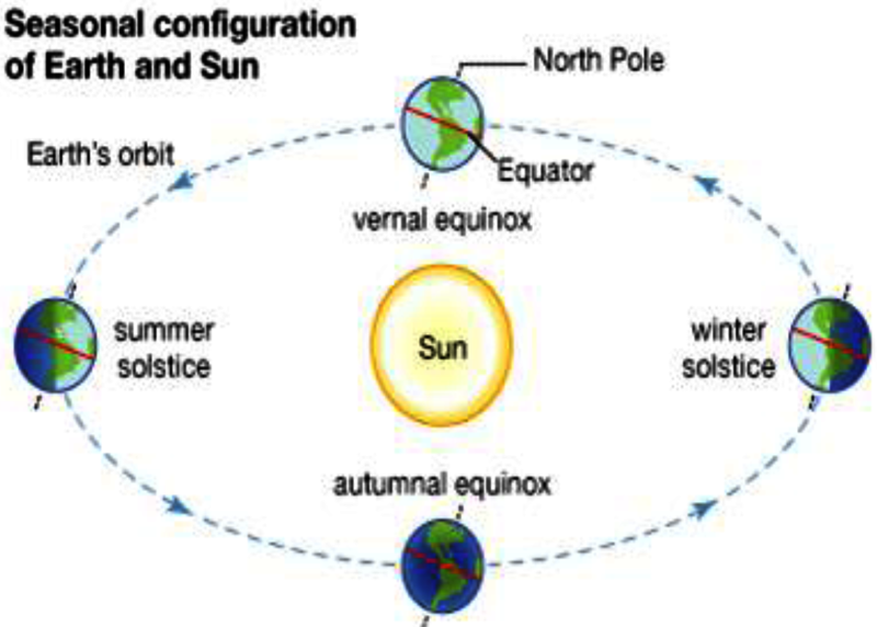
MARCH 21 – VERNAL EQUINOX
diffusion.
- Sun is above the Equator.
- Day and Night are equal throughout the world.
- Spring season begins from vernal equinox.
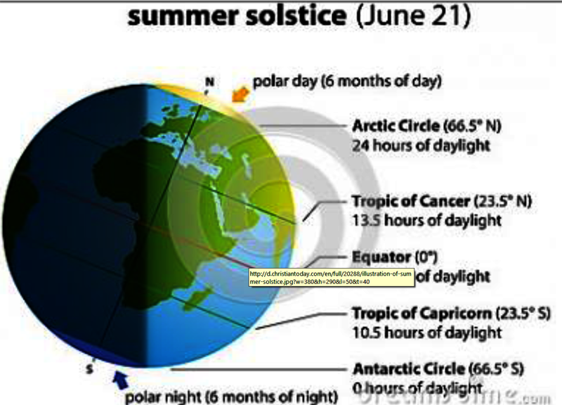
JUNE 22 – SUMMER SOLSTICE
- Sun moves towards North and is above the Tropic of Capricorn.
- In the Northern Hemisphere, daytime is lengthier than night time.
- Summer in Northern Hemisphere and winter in Southern Hemisphere.
- In North Pole (Arctic) sunrays will fall 6 month during this period.
SEPTEMBER 23 – AUTUMNAL EQUINOX
- Sun is above the Equator.
- Day and Night is Equal throughout the world.
- This is the beginning of Autumn Season.
DECEMBER 22 – WINTER SOLSTICE
- Sun is above the Tropic of Capricorn.
- Winter in Northern Hemisphere and summer in Southern Hemisphere.
- In Antarctica 6 months sun rays (daytime) during this period. But in Arctic 6 months night time.
THE PASSAGE OF SOLAR RADIATION THROUGH THE ATMOSPHERE
- The atmosphere is largely transparent to short wave solar radiation.
- The incoming solar radiation passes through the atmosphere before striking the earth’s surface.
- Within the troposphere, water vapour, ozone and other gases absorb much of the near infrared radiation.
- Very small-suspended particles in the troposphere scatter visible spectrum both to the space and towards the earth surface. This process adds colour to the sky.
- The red colour of the rising and the setting sun and the blue colour of the sky are the result of scattering of light within the atmosphere.
SPATIAL DISTRIBUTION OF INSOLATION AT THE EARTH’S SURFACE
- The insolation received at the surface varies from about 320 Watt/m2 in the tropics to about 70 Watt/m2 in the poles.
- Maximum insolation is received over the subtropical deserts, where the cloudiness is the least.
- Equator receives comparatively less insolation than the tropics.
- Generally, at the same latitude the insolation is more over the continent than over the oceans.
- In winter, the middle and higher latitudes receive less radiation than in summer.
HEATING AND COOLING OF ATMOSPHERE
- There are different ways of heating and cooling of the atmosphere.
- The earth after being heated by insolation transmits the heat to the atmospheric layers near to the earth in long wave form.
- The air in contact with the land gets heated slowly and the upper layers in contact with the lower layers also get heated. This process is called conduction.
- Conduction takes place when two bodies of unequal temperature are in contact with one another; there is a flow of energy from the warmer to cooler body.
- The transfer of heat continues until both the bodies attain the same temperature or the contact is broken.
CONDUCTION & CONVECTION
- Conduction is important in heating the lower layers of the atmosphere.
- The air in contact with the earth rises vertically on heating in the form of currents and further transmits the heat of the atmosphere. This process of vertical heating of the atmosphere is known as convection.
- The convective transfer of energy is confined only to the troposphere.
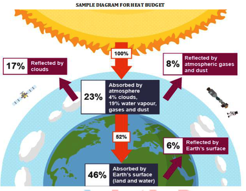
ILLUSTRATION FOR HEAT BUDGET
For example out of 100 units, 35 units are reflected back to space even before reaching the earth’s surface. Of these, 27 units are reflected back from the top of the clouds and 2 units from the snow and ice-covered areas of the earth. The reflected amount of radiation is called the albedo of the earth. The remaining 65 units (out of 100) are absorbed, 14 units within the atmosphere and 51 units by the earth’s surface. The earth radiates back 51 units in the form of terrestrial radiation. Of these, 17 units are radiated to space directly and the remaining 34 units are absorbed by the atmosphere (6 units absorbed directly by the atmosphere, 9 units through convection and turbulence and 19 units through latent heat of condensation). 48 units absorbed by the atmosphere (14 units from insolation +34 units from terrestrial radiation) are also radiated back into space. Thus, the total radiation returning from the earth and the atmosphere respectively is 17+48=65 units which balance the total of 65 units received from the sun. This is termed the heat budget or heat balance of the earth.
ADVECTION
- The transfer of heat through horizontal movement of air is called advection.
- Horizontal movement of the air is relatively more important than the vertical movement. In middle latitudes, most of diurnal (day and night) variation in daily weather is caused by advection alone.
- In tropical regions particularly in northern India during summer season local winds called ‘loo’ is the outcome of advection process.
3.4. TERRESTRIAL RADIATION
- The insolation received by the earth is in short waves forms and heats up its surface.
- The earth after being heated itself becomes a radiating body and it radiates energy to the atmosphere in long wave form. This energy heats up the atmosphere from below. This process is known as terrestrial radiation.
- The long wave radiation is absorbed by the atmospheric gases particularly by carbon dioxide and the other greenhouse gases.
- Thus, the atmosphere is indirectly heated by the earth’s radiation.
The atmosphere in turn radiates and transmits heat to the space. Finally the amount of heat received from the sun is returned to space, thereby maintaining constant temperature at the earth’s surface and in the atmosphere.
3.5. HEAT BUDGET OF THE PLANET EARTH
- The earth as a whole does not accumulate or lose heat. It maintains its temperature.
- This can happen only if the amount of heat received in the form of insolation equals the amount lost by the earth through terrestrial radiation.
- While passing through the atmosphere some amount of energy is reflected, scattered and absorbed. Only the remaining part reaches the earth surface.
- Heat budget explains, why the earth neither warms up nor cools down despite the huge transfer of heat that takes place.
3.5.1. Variation in the Net Heat Budget At The Earth’s Surface
- As explained earlier, there are variations in the amount of radiation received at the earth’s surface.
- Some part of the earth has surplus radiation balance while the other part has deficit.
- There is a surplus of net radiation balance between 40 degrees north and south and the regions near the poles have a deficit.
- The surplus heat energy from the tropics is redistributed pole wards and as a result the tropics do not get progressively heated up due to the accumulation of excess heat or the high latitudes get permanently frozen due to excess deficit.
3.6. TEMPERATURE
- The interaction of insolation with the atmosphere and the earth’s surface creates heat which is measured in terms of temperature.
While heat represents the molecular movement of particles comprising a substance, the temperature is the measurement in degrees of how hot (or cold) a thing (or a place) is.
3.6.1. Factors Controlling Temperature Distribution
- The temperature of air at any place is influenced by (i) the latitude of the place; (ii) the altitude of the place; (iii) distance from the sea, the air mass circulation; (iv) the presence of warm and cold ocean currents; (v) local aspects.
i. THE LATITUDE
- The temperature of a place depends on the insolation received.
- It has been explained earlier that the insolation varies according to the latitude hence the temperature also varies accordingly.
ii. THE ALTITUDE
- The atmosphere is indirectly heated by terrestrial radiation from below.
- Therefore, the places near the sea-level record higher temperature than the places situated at higher elevations. In other words, the temperature generally decreases with increasing height.
- The rate of decrease of temperature with height is termed as the normal lapse rate. It is 6.5°C per 1,000 m.
iii. DISTANCE FROM THE SEA
- Another factor that influences the temperature is the location of a place with respect to the sea.
- Compared to land, the sea gets heated slowly and loses heat slowly and Land heats up and cools down quickly.
- Therefore, the variation in temperature over the sea is less compared to land.
- The places situated near the sea come under the moderating influence of the sea and land breezes which moderate the temperature.
iv. AIR-MASS AND OCEAN CURRENTS
- Like the land and sea breezes, the passage of air masses also affects the temperature.
- The places, which come under the influence of warm air-masses
- experience higher temperature and the places that come under the influence of cold air masses experience low temperature.
- Similarly, the places located on the coast where the warm ocean currents flow record higher temperature than the places located on the coast where the cold currents flow.
Isotherms
- It follows the parallels of Latitudes in an east west direction.
- There is a shift in the position of isotherms with the change of season.
- Where horizontal temperature changes are large, Isotherms are closely spaced.
- Where horizontal temperature differences are less, Isotherms are widely spaced.
- Due to differential heating of land and water, temperature above the oceans and land masses varies even on the same latitude. Isotherms, therefore, bend slightly while crossing from landmasses to oceans and vice versa.
3.7. HORIZONTAL DISTRIBUTION OF TEMPERATURE
- Normally, Temperature decreases from Equator to pole.
- The highest temperatures are found in the tropics and sub-tropics.
- They receive the largest amount of insolation throughout the year. On the other hand, lowest temperatures are recorded in Polar Regions, where the amount of solar energy received is very small.
- The temperature distribution is generally shown on the map with the help of isotherms and the horizontal distribution of temperature is represented and studied with the help of isotherms.
- The Isotherms are lines joining places having equal temperature.
- In general, the effect of the latitude on temperature is well pronounced on the map, as the isotherms are generally parallel to the latitude.
- In the northern hemisphere the land surface area is much larger than in the southern hemisphere. Hence, the effects of land mass and the ocean currents are well pronounced.
- Isotherms within the tropics are widely spaced as temperature gradient is very gentle and insignificant.
- The temperature gradient is very steep in higher latitudes as well as on the eastern margins of the continents.
3.8. STUDY OF TEMPERATURE DISTRIBUTION
- For most places on the earth, January and July represent the seasonal extremes of temperature.
- Therefore, the global distribution of temperature can well be understood by studying the temperature distribution in January and July.
3.8.1. Global Distribution of Temperature In January
- The sun shines almost vertically over Tropic of Capricorn in the month of
- It is winter in the northern hemisphere and summer in the southern hemisphere.
- In the northern hemisphere, land mass is cooler than the oceans.
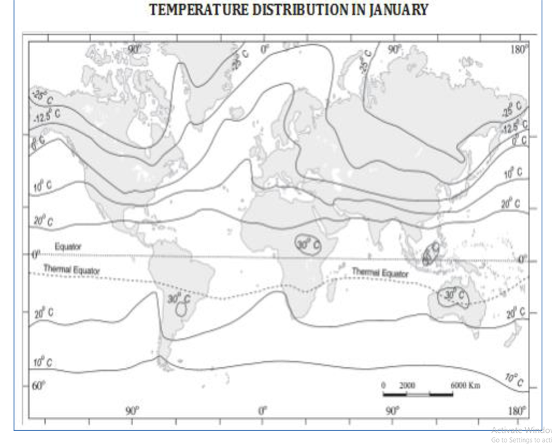
- As a result, lowest temperature occurs in north-east Asia and Greenland. Verkhoyansk (Siberia) experiences mean January temperature of -500 C.
- In the southern hemisphere, the conditions during this season are just the reverse.
- Temperature is, therefore, high over the land mass in the southern hemisphere rising over 300 C in four areas – north – west Argentina, east – central Africa, Borneo and Central Australia.
- The effect of the ocean is well pronounced in the southern hemisphere. Here the isotherms are more or less parallel to the latitudes and the variation in temperature is more gradual than in the northern hemisphere.
ISOTHERMS DURING JANUARY
- In January, the isotherms deviate to the north over the ocean and to the south over the continent. This can be seen on the North Atlantic Ocean.
- The presence of warm ocean currents like Gulf Stream and North Atlantic drift, make the Northern Atlantic Ocean warmer and the isotherms bend towards the north.
- Over the land the temperature decreases sharply and the isotherms bend towards south in Europe. It is much pronounced in the Siberian plain.
- As the air over the ocean is warmer than that over the landmasses in the northern hemisphere, the isotherms bend equator ward while crossing the landmasses and poleward while crossing the oceans.
- Therefore, the isotherms bend equator ward while crossing the oceans and pole ward while crossing the landmasses.
- Due to the presence of vast expanse of landmasses, isotherms are irregular and closely spaced in the northern hemisphere.
- They are more regular and widely spaced in the southern hemisphere.
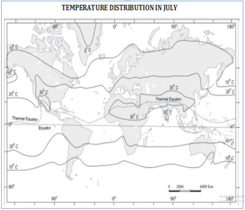
3.8.2. Global Distribution Of Temperature In July
- In July, the isotherms generally run parallel to the latitude.
- At this time of the year, the sun shines almost vertically above the Tropic of Cancer in the northern hemisphere.
- It is summer for the northern hemisphere and winter for the southern hemisphere.
- Maximum temperature of over 300 C occurs entirely in the northern hemisphere between 100 and 400 N latitudes. The areas include the south-eastern USA, the Sahara, Arabia, Iraq, Iran, Afghanistan, large part of China and a small part of south India.
PHYSICAL GEOGRAPHY
- However, the temperature remains below freezing point in Greenland and the mountain highlands.
- The highest range of temperature is more than 60°C over the north-eastern part of Eurasian continent. This is due to continentality.
- The least range of temperature 3°C, is found between 20° S and 15° N.
ISOTHERMS DURING JULY
- In the northern hemisphere, the isotherms bend equator ward while crossing the oceans and poleward while crossing the land masses.
- In the southern hemisphere, it is vice versa. Isotherms reveal wider spacing on the ocean than on the continents.
3.9. VERTICAL DISTRIBUTION OF TEMPERATURE
- Temperature decreases with increasing height in the troposphere but the rate of decrease varies according to seasons, duration of sunshine and location.
- On an average, the rate of decrease of temperature with increasing altitudes in a stationary column of air with absence of any vertical motion is 6.50 C per 1000 metres.
- This decrease of temperature is called vertical temperature gradient or normal lapse rate. The decrease of temperature upward in the atmosphere proves the fact that the atmosphere gets heat from the earth’s surface through the processes of conduction, radiation and convection.
3.10. INVERSION OF TEMPERATURE
- Under normal conditions, the temperature of the atmosphere falls with altitude.
- But there are some special conditions under which the atmospheric temperature increases instead of decreasing with height.
- This rise of temperature with height is known as inversion of temperature.
- It is clear that in case of inversion of temperature, the air near the earth’s surface is cold while higher above it is warm.
3.10.1. Following Conditions Favour Inversion Of Temperature
1. LONG NIGHTS
- Insolation is received during day time and it is radiated during night.
- The earth’s surface cools down at night due to radiation.
- The air of the lower layer touching the earth’s surface is sufficiently cooled while the air of upper layer is still warm.
- Thus, long nights are helpful for inversion of temperature.
2. CLEAR SKY
- Clear sky is essential for reflection of heat radiations by earth’s surface thereby cooling it.
- Clouds obstruct this reflection and hamper the occurrence of inversion of temperature.
3. STABLE WEATHER
- Continuous radiation of heat is possible in a stable weather.
- This condition leads to temperature inversion. Change in weather disturbs the temperature inversion.
4. DRY AIR
- Moist air has greater capacity to absorb heat radiation and obstructs the temperature inversion.
- But dry air does not absorb much radiation and promotes temperature inversion.
5. ICE COVER
- Areas covered with ice reflect most of the heat radiation and the layer of air touching it becomes cold while the upper air remains warm. This leads to temperature inversion.
AIR DRAINAGE
- During long winter nights, the air on higher slopes cools down quickly and becomes dense.
- It moves down the slope and settles down on the valley bottom by pushing up the comparatively warmer air.
- Sometimes, the temperature of the air at the valley bottom falls below freezing point, whereas the air at higher altitude remains comparatively warm.
- This is known as ‘Air Drainage Temperature Inversion’.
3.10.2. WEATHER INFLUENCE
- Surface inversion promotes stability in the lower layers of the atmosphere.
- Smoke and dust particles get collected beneath the inversion layer and spread horizontally to fill the lower strata of the atmosphere.
- Dense fogs in mornings are common occurrences especially during winter season.
- This inversion commonly lasts for few hours until the sun comes up and beings to warm the earth.
- The inversion occurs upto the height of 30-40 feet in the low latitudes, a few hundred feet in the middle latitudes and half a mile in the high latitudes.
- It is apparent that the duration and height of surface inversion increase poleward. This inversion promotes stability in the lower portion of the atmosphere and causes dense fogs.
- Fog is formed due to the situation of warm air above and cold air below because the warm air is cooled from below and resultant condensation causes the formation of tiny droplets around suspended dust particles and smokes during winter nights.
- The smokes coming out of houses and chimneys intensify fogs and become responsible for the occurrence of urban smogs.
- When smog is mixed with air pollutants such as sulphur dioxide it becomes poisonous and deadly health hazard to human beings.
- Fogs reduce atmospheric visibility and thus they are responsible for several cases of accidents of air crafts while taking off and landing and ships in the oceans.
- Though generally fogs are unfavourable for many agricultural crops such as grams, peas, mustard plants, wheat, etc. but sometimes they are also favourable for some crops such as coffee plants in Yemen hills of Arabia where fogs protect coffee plants from direct strong sun’s rays.
- Inversion of temperature causes frost when the condensation of warm air due to its cooling by cold air below occurs at temperature below freezing point.
Frost is definitely economically unfavourable weather phenomenon mainly for crops because fruit orchards and several agricultural crops such as potatoes, tomatoes, peas etc. are totally damaged overnight.
- The valley floors in the hills of Brazil are avoided for coffee cultivation because of frequent frosts. Alternatively, coffee is planted on the upper slopes of the valleys.
- The upper parts of the valleys are inhabited in Switzerland while lower parts are avoided.
- Inversion of temperature causes atmospheric stability which stops upward (ascent) and downward (descent) movements of air. The atmospheric stability discourages rainfall and favours dry condition.
3.10.3. Areas Affecting Inversion of Temperature
- The heat of the day is radiated off during the night, and by early morning hours, the earth is cooler than the air above.
- Over polar areas, temperature inversion is normal throughout the year.
- Snow covered ground surface, so that there is maximum reflection of incoming solar radiation.
3.10.4. EFFECTS
- In the mountain valleys, the trees are frost-bitten along the lower
slopes, whereas those at higher levels are free from it.
- Air pollutants such as dust particles and smoke do not disperse in the valley bottoms.
- Because of these reasons, houses and farms in intermontane valleys are generally situated along the upper slopes, avoiding the cold and foggy valley bottoms.
- For example, mulberry planters in the Suwa Basin of Japan and apple growers in the mountain states of the Himalayas avoid lower slopes.
- Similarly, the hotels at holiday resorts in the Himalayas are built on the upper slopes.
3.11. DIURNAL OR DAILY RANGE OF TEMPERATURE
- The difference between the maximum and minimum temperature of one day is the diurnal range of temperature.
- The diurnal range is much larger on land than at sea.
- A cloudy day has smaller daily range of temperature than a clear day.
- STABILITY: Atmospheric stability is directly related to the fluctuations of daily range of temperature. The inversion of temperature lowers the daily range of temperature.
- NATURE OF THE SURFACE: The place with marine influence, have smaller diurnal range of temperature. Therefore the place situated far away from the ocean has the moderate influence of the oceans have higher diurnal range of temperature.
- WIND SPEED: Maximum temperature on a windy day is certainly on a day with gusty winds, the diurnal range of temperature is relatively smaller.
- WATER VAPOUR CONTENT: Larger amount of water vapour in the air absorbs a large percentage of radiant heat from the earth’s surface. Therefore if the humid air is more, lesser is the diurnal range of temperature, drier the air and larger is the diurnal range.
- EFFECT OF LATITUDE: The diurnal range is the highest near the ground and decreases upward.
Greatest in desert regions which record high daytime temp followed by a rapid heat loss through radiation at night, owing to clear skies.
3.12. ANNUAL RANGE OF TEMPERATURE
- The Difference between the mean temperature of the hottest month and the mean temperature of the coldest month is the annual range of temperature.
Controlling factors:
- The following are the factors that affect and control the annual range of temperature in the same way as they as they do the horizontal distribution of temperature:
latitude, height above the mean sea level; ocean currents; prevailing winds; precipitation and cloudiness; local relief; and distance from the sea.
1 LATITUDE
- It increases from the equator to the poles.
- The mid-latitude regions, where the seasonal variation in temperature is greatest, record the highest annual range of temperature.
- In Equator, sun’s rays are always direct and so it is always hot. So less Annual Range of temperature is observed here.
- Largest Range occurs in the subpolar locations, in Siberia, where range 640C have been recorded.
2 HEIGHT ABOVE MEAN SEA LEVEL
- At high elevations, the rarity of the air, larger amount of precipitation and cloudiness combine together to lower down the average temperature even during the warmer months of the year.
- But the mean values of temperature for the colder part of the year are not affected by these factors.
- Thus, places situated at higher elevations have lower annual ranges of temperature.
3 PREVALING WINDS
- Off-shore winds bring about an increase in the annual range of temperature of the adjacent land, while the on-shore winds carry the moderating influence of the oceans far inland and impose a restriction on the annual range.
4 PRECIPITATION AND CLOUDINESS
- In those regions where the rains are falling or where the skies are covered with clouds, the summer temperatures are relatively lower.
- But during the winter, the clouds check the loss of heat by terrestrial radiation. Thus, in cloudy regions the winter time temperatures are not allowed to fall much. Therefore in such regions the annual range of temperature is relatively smaller than those regions where the weather is clear and dry.
5 LOCAL RELIEF
- The slopes facing the sun have higher temperatures during summer months, and the slopes protected from the sun have much lower temperatures during winter. Thus, this local factor also affects the annual range of temperature.
6 DISTANCE FROM THE SEA
- Water is heated or cooled in a longer period of time than land.
- The coastal areas enjoy a moderate climate, and the difference in temperature of the warmest and the coldest months is not very large.
- On the contrary, the interior locations have extremely hot summers and cold winters. Thus, with increasing distance from the sea-coast, there is a corresponding increase in the seasonal variation of temperatures.
- Its effect is more marked in the temperate regions.
4. ATMOSPHERIC PRESSURE
4.1. INTRODUCTION
- Air expands when heated and gets compressed when cooled. This results in variations in the atmospheric pressure.
- The result is that it causes the movement of air from high pressure to low pressure, setting the air in motion.
- Air in horizontal motion is wind.
- Atmospheric pressure also determines when the air will rise or sink.
- The wind redistributes the heat and moisture across the planet, thereby, maintaining a constant temperature for the planet as a whole.
- The vertical rising of moist air cools it down to form the clouds and bring precipitation.
4.2. ATMOSPHERIC PRESSURE
- As one moves up the air gets varified and one feels breathless.
- The weight of a column of air contained in a unit area from the mean sea level to the top of the atmosphere is called the atmospheric pressure.
- The atmospheric pressure is expressed in units of mb and Pascals.
- The widely used unit is kilo Pascal written as hPa.
- At sea level, the average atmospheric pressure is 1,013.2 mb or 1,013.2 hPa.
- Due to gravity the air at the surface is denser and hence has higher pressure.
- Air pressure is measured with the help of a mercury barometer or the aneroid barometer.
- The pressure decreases with height.
- At any elevation, it varies from place to place and its variation is the primary cause of air motion, i.e. wind which moves from high pressure areas to low pressure areas.
4.3. VERTICAL VARIATION OF PRESSURE
- In the lower atmosphere, the pressure decreases rapidly with height. The decrease amounts to about 1 mb for each 10 m increase in elevation.
- It does not always decrease at the same rate.
- The vertical pressure gradient force is much larger than that of the horizontal pressure gradient.
- But, it is generally balanced by a nearly equal but opposite gravitational force. Hence, we do not experience strong upward winds.
4.4. HORIZONTAL DISTRIBUTION OF PRESSURE
- Small differences in pressure are highly significant in terms of the wind direction and velocity.
- Horizontal distribution of pressure is studied by drawing isobars at constant levels.
- Isobars are lines connecting places having equal pressure. In order to eliminate the effect of altitude on pressure, it is measured at any station after being reduced to sea level for purposes of comparison.
- The sea level pressure distribution is shown on weather maps.
- Low pressure system is enclosed by one or more isobars with the lowest pressure in the centre.
- High-pressure system is also enclosed by one or more isobars with the highest pressure in the centre.
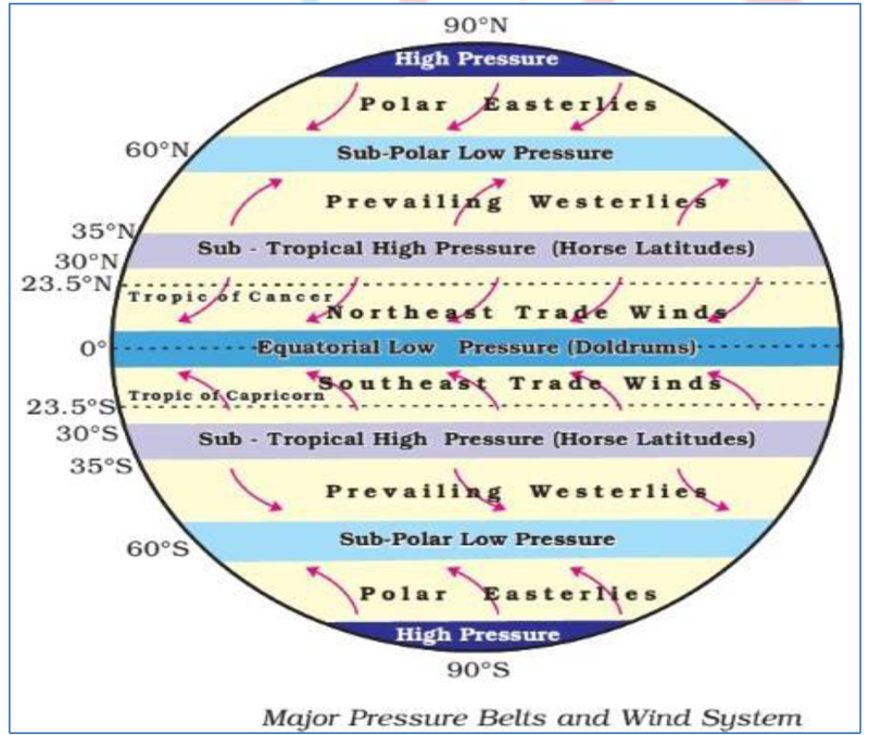
4.5. WORLD DISTRIBUTION OF SEA LEVEL PRESSURE
- The world distribution of sea level pressure in January and July has been shown.
- Near the equator the sea level pressure is low and the area is known as equatorial low.
- Along 30° N and 30° S are found the high-pressure areas known as the subtropical highs.
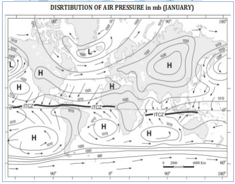
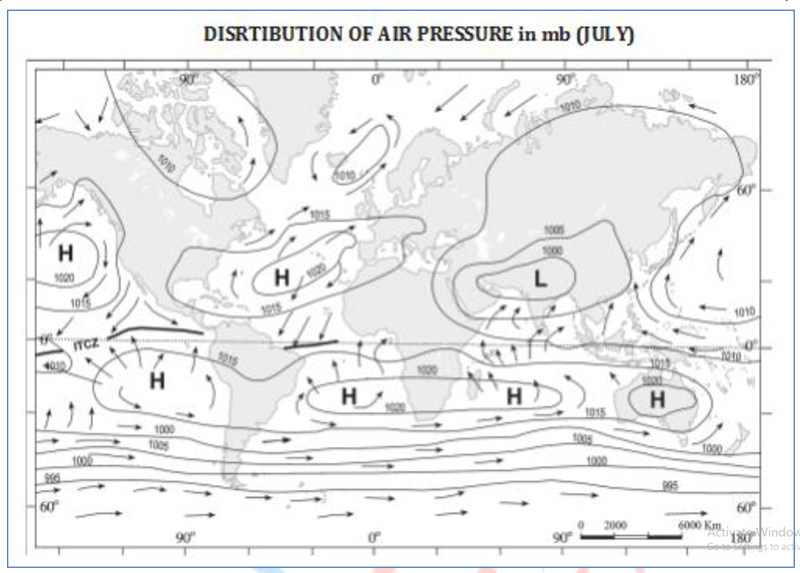
- Further pole wards along 60° N and 60° S, the low-pressure belts are termed as the sub polar lows.
- Near the poles the pressure is high and it is known as the polar high.
- These pressure belts are not permanent in nature.
- They oscillate with the apparent movement of the sun. In the northern hemisphere in winter they move southwards and in the summer northwards.
4.6.FORCES AFFECTING THE VELOCITY AND DIRECTION OF WIND
- Air is set in motion due to the differences in atmospheric pressure. The air in motion is called wind.
- The wind blows from high pressure to low pressure.
- The wind at the surface experiences friction.
- In addition, rotation of the earth also affects the wind movement.
- The force exerted by the rotation of the earth is known as the Coriolis force.
- Thus, the horizontal winds near the earth surface respond to the combined effect of three forces – the pressure gradient force, the frictional force and the Coriolis force. In addition, the gravitational force acts downward.
PRESSURE GRADIENT FORCE
- The differences in atmospheric pressure produce a force.
- The rate of change of pressure with respect to distance is the pressure gradient.
- The pressure gradient is strong where the isobars are close to each other and is weak where the isobars are apart.
FRICTIONAL FORCE
- It affects the speed of the wind. It is greatest at the surface and its influence generally extends upto an elevation of 1 – 3 km.
- Over the sea surface the friction is minimal.
CORIOLIS FORCE
- The rotation of the earth about its axis affects the direction of the wind.
- This force is called the Coriolis force after the French physicist who described it in 1844.
- It deflects the wind to the right direction in the northern hemisphere and to the left in the southern hemisphere.
- The deflection is more when the wind velocity is high.
- The Coriolis force is directly proportional to the angle of latitude. It is maximum at the poles and is absent at the equator.
- The Coriolis force acts perpendicular to the pressure gradient force.
- The pressure gradient force is perpendicular to an isobar.
- The higher the pressure gradient force, the more is the velocity of the wind and the larger is the deflection in the direction of wind.
- As a result of these two forces operating perpendicular to each other, in the low-pressure areas the wind blows around it.
- At the equator, the Coriolis force is zero and the wind blows perpendicular to the isobars. The low pressure gets filled instead of getting intensified.
- That is the reason why tropical cyclones are not formed near the equator.
4.7. PRESSURE AND WIND
- The velocity and direction of the wind are the net result of the wind generating forces.
- The winds in the upper atmosphere, 2 – 3 km above the surface, are free from frictional effect of the surface and are controlled by the pressure gradient and the Coriolis force.
- When isobars are straight and when there is no friction, the pressure gradient force is balanced by the Coriolis force and the resultant wind blows parallel to the isobar.
- This wind is known as the geostrophic wind.
- The wind circulation around a low is called cyclonic circulation and around a high it is called anti cyclonic circulation.
- The direction of winds around such systems changes according to their location in different hemispheres.
- The wind circulation at the earth’s surface around low and high on many occasions is closely related to the wind circulation at higher level.
- Generally, over low pressure area the air will converge and rise and in over high pressure area the air will subside from above and diverge at the surface.
- Apart from convergence, some eddies, convection currents, orographic uplift and uplift along fronts cause the rising of air, which is essential for the formation of clouds and precipitation.
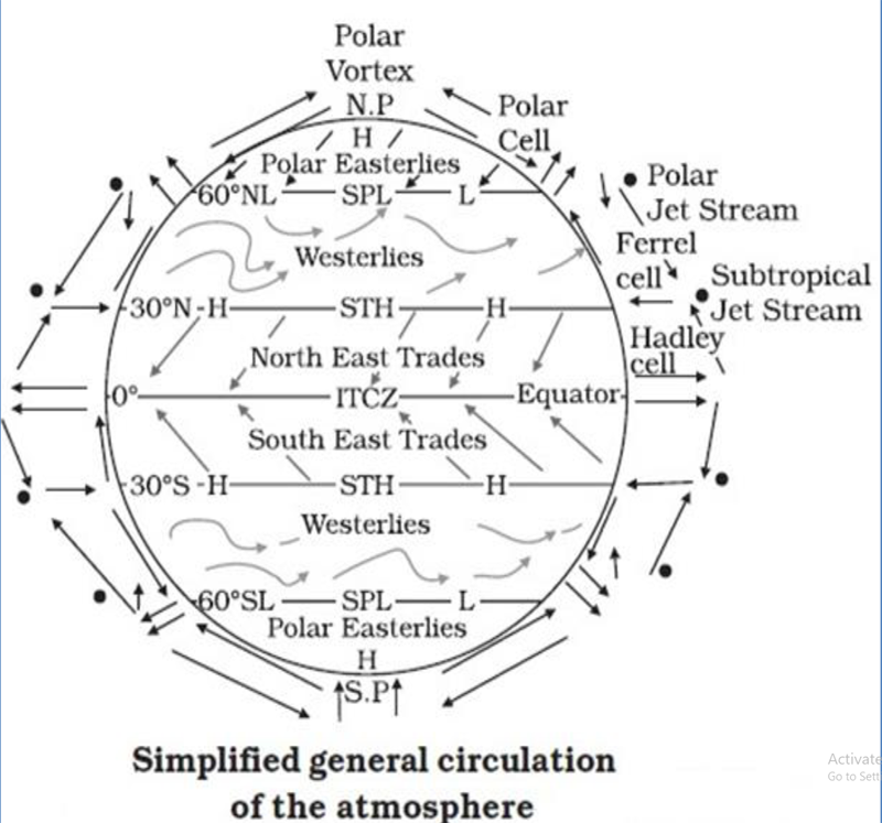
4.8. GENERAL CIRCULATION OF THE ATMOSPHERE
The pattern of planetary winds largely depends on :
(i) latitudinal variation of atmospheric heating;
(ii) emergence of pressure belts;
(iii) the migration of belts following apparent path of the sun;
(iv) the distribution of continents and oceans;
(v) the rotation of earth.
- The pattern of the movement of the planetary winds is called the general circulation of the atmosphere.
- The general circulation of the atmosphere also sets in motion the ocean water circulation which influences the earth’s climate.
- The air at the Inter Tropical Convergence Zone (ITCZ) rises because of convection caused by high insolation and a low pressure is created.
- The winds from the tropics converge at this low pressure zone.
- The converged air rises along with the convective cell.
- It reaches the top of the troposphere up to an altitude of 14 km and moves towards the poles.
- This causes accumulation of air at about 30° N and S.
- Part of the accumulated air sinks to the ground and forms a subtropical high.
- Another reason for sinking is the cooling of air when it reaches 30° N and S latitudes.
- Down below near the land surface the air flows towards the equator as the easterlies.
- The easterlies from either side of the equator converge in the Inter Tropical Convergence Zone (ITCZ).
- Such circulations from the surface upwards and vice-versa are called cells. Such a cell in the tropics is called Hadley Cell.
- In the middle latitudes the circulation is that of sinking cold air that comes from the poles and the rising warm air that blows from the subtropical high.
- At the surface these winds are called Westerlies and the cell is known as the Ferrel cell.
- At polar latitudes the cold dense air subsides near the poles and blows towards middle latitudes as the polar easterlies. This cell is called the Polar cell.
- These three cells set the pattern for the general circulation of the atmosphere.
- The transfer of heat energy from lower latitudes to higher latitudes maintains the general circulation.
- The general circulation of the atmosphere also affects the oceans.
- The large-scale winds of the atmosphere initiate large and slow moving currents of the ocean.
- Oceans in turn provide input of energy and water vapour into the air.
- These interactions take place rather slowly over a large part of the ocean.
4.9. WORLD PRESSURE BELTS
- There is a circulation of air over the surface of the earth caused by the differences in pressure.
- Along the equator and within 5 degrees north and south, is the Equatorial Low Pressure Belt, where there is intense heating, with expanding air and ascending convection currents. This equatorial belt is often termed the Doldrums, because sailors in the olden days often found themselves becalmed here. It is a zone of wind convergence.
- About 30oN and 30°S occur the Sub-Tropical High Pressure Belts where the air is comparatively dry and the winds are calm and light. It is a region of descending air currents or wind divergence and anticyclones. It is frequently referred to as the Horse Latitudes.
- Around the latitudes 60oN and 60°S are two Temperate Low Pressure Belts which are also zones of convergence with cyclonic activity. The sub-polar low pressure areas are best developed over the oceans, where temperature differences between summer and winter are negligible.
- At the North and South Poles 90oN and 90°S where temperature are permanently low, are the Polar High Pressure Belts.
- Unlike the water masses of the high latitudes in the southern hemisphere, high pressures of the corresponding latitude in the northern hemisphere are a little complicated by the presence of much land. Some pressure differences between summer and winter can be expected.
4.10. GENERAL ATMOSPHERIC CIRCULATION AND ITS EFFECTS ON OCEANS
- Warming and cooling of the Pacific Ocean is most important in terms of general atmospheric circulation. The warm water of the central Pacific Ocean slowly drifts towards South American coast and replaces the cool Peruvian current.
- Such appearance of warm water off the coast of Peru is known as the El Nino. The El Nino event is closely associated with the pressure changes in the Central Pacific and Australia.
- This change in pressure condition over Pacific is known as the southern oscillation.
- The combined phenomenon of southern oscillation and El Nino is known as ENSO.
- In the years when the ENSO is strong, large-scale variations in weather occur over the world.
- The arid west coast of South America receives heavy rainfall; drought occurs in Australia and sometimes in India and floods in China.
- This phenomenon is closely monitored and is used for long range forecasting in major parts of the world.
EL NINO
- ELNINO, Spanish for ‘boy child’ (because of the tendency of the phenomenon to arrive around Christmas), is an abnormal warming of water in the Equatorial Pacific Ocean every three to five years and can last up to 18 months).
- Severe cases of EL NINO, as in 1997 / 98 are responsible for drought, flooding, as well as areas of formation for tropical cyclones and severe winter storms. T
- he 1997/98 ELNINO and its associated impacts have been blamed for the deaths of hundreds of people and caused billions of dollars of damage in an estimated 15 countries especially in the Panama canal region but also as far away as the east coast of Africa.
LA NINA
- LA NINA means ‘the little girl’ the opposite of EL NINO, and refers to the abnormal cooling of the ocean temperatures in the equatorial east central pacific ocean.
SOUTHERN OSCILLATION (SO)
- ‘SO’ is a ‘see-saw’ in the surface air pressure between eastern and western tropical pacific.
- It is characterized by simultaneously opposite sea level pressure anomalies at Tahiti, in the eastern Tropical pacific and Darwin, on the northwest coast of Australia.
- The SO was discovered by sir Gillbert walker in the early 1920’s.
- Later, the three dimensional east-west circulations related to the SO was discovered and named the walker circulation.
- The SO has periodicity of about 2-5 years.
- A most common index of so is computed as the difference between standardized sea level pressure anomalies at Tahiti and Darwin.
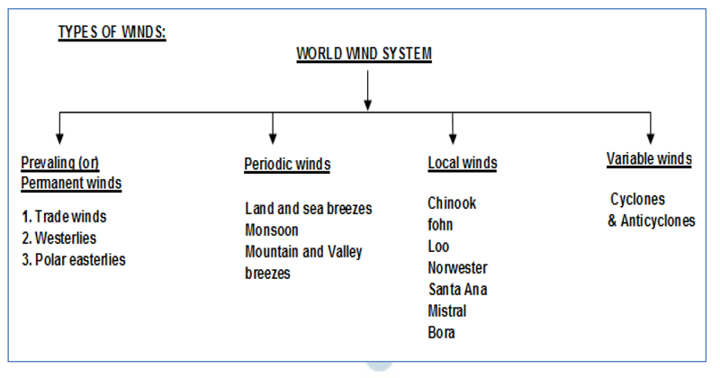
5. PLANETARY WINDS
5.1. WIND – INTRODUCTION
- Horizontal pressure differences result in horizontal movement of air called wind.
- Air flows from the areas of high pressure to the areas of low pressure. This flow of air is nature’s attempt to balance the inequalities in air pressure. (Pressure gradient force)
- Wind direction is affected by two main factors.
- friction with the earth’s surface
- Coriolis effect
- The frictional effect on wind is important only within the first few kilometres from the earth’s surface. It slows air movement and consequently alters wind direction.
- Coriolis Effect results from the curving motion of winds due to rotation of the earth and deflects winds to the right of their flow in the Northern Hemisphere and to the left of their flow in the Southern Hemisphere. This deflection is maximum at the poles and minimum at the Equator.
5.2. THE PLANETARY WINDS
- Within this pattern of permanent pressure belts on the globe, winds tend to blow from the high pressure belts to the low pressure belts as the planetary winds.
- Instead of blowing directly from one pressure belt to another, the effect of the rotation of the earth (Coriolis Force) tends to deflect the direction of the winds.
- In the northern hemisphere, winds are deflected to their right, and in the southern hemisphere to their left as shown.
- This is known as Ferrel’s Law of Deflection.
- The Coriolis force is absent along the equator but increases progressively towards the poles.
- For this reason, winds blowing out from the Sub-Tropical High Pressure Belt in the northern hemisphere towards the Equatorial Low become North-East Trade Winds and those in the southern hemisphere become the South-East Trade winds. These trade winds are the most regular of all the planetary winds.
- They blow with great force and in a constant direction.
- They were thus helpful to early traders who depended on the wind when sailing the high seas; hence named as ‘trade winds’.
Ferrels’s law
- All moving bodies like wind and ocean currents get deflected from their normal paths towards right in the northern hemisphere and towards left in the southern hemisphere due to the rotation of the earth. (coriolis force)
- Coriolis force is zero in Equator.
- It is increasing from Equator to poles. So the rate of deflection also increases with the distance from the Equator.
- Since they blow from the cooler sub-tropical latitudes to the warmer tropics, they have great capacity for holding moisture: In their passage across the open oceans, they gather more moisture and bring heavy rainfall to the east coasts of continents within the tropics.
- As they are off-shore on the west coast, these regions suffer from great aridity and form the Trade Wind Hot Deserts of the world, e.g. the Sahara, Kalahari, Atacama and the Great Australian Deserts.
- From the Sub-Tropical High Pressure Belts, winds blow towards the Temperate Low Pressure Belts as the variable Westerlies.
- Under the effect of the Coriolis force, they become the South-Westerlies in the northern hemisphere and the North-Westerlies in the southern hemisphere.
- They are more variable in the northern hemisphere, but they play a valuable role in carrying warm equatorial waters and winds to western coasts of temperate lands.
- This warming effect and other local pressure differences have resulted in a very variable climate in the temperate zones, dominated by the movements of cyclones and anticyclones.
- In the southern hemisphere where there is a large expanse of ocean, from 400S to 600S, Westerlies blow with much greater force and regularity throughout the year. They bring much precipitation to the western coasts of continents.
- The weather is damp and cloudy and the seas are violent and stormy.
Seafarers refer the Westerlies as the Roaring Forties, Furious Fifties and Shrieking or Stormy Sixties, according to the varying degree of storminess in the latitudes in which they blow.
- It is to be noted that not all the western coasts of the temperate zone receive Westerlies throughout the year. Some of them like California. Iberia, central Chile, southern Africa and south-western Australia receive Westerlies only in winter. This is caused by the ‘shifting of the wind belts‘ or such regions which lie approximately between the latitudes 30° and 40°N and S. Due to the earth’s inclination, the sun is overhead at midday in different parts of the earth at different seasons.
- The entire system of pressure and wind belts follows the movement of the midday sun.
- In June when the overhead sun is over the Tropic of Cancer, all the belts move about 5°-10° north of their average position. The ‘Mediterranean’ parts of the southern continents then come under the influence of the Westerlies and receive rain in June (winter in the southern hemisphere).
- The ‘Mediterranean’ parts of Europe and California then come under the influence of the Westerlies and receive rain in December (winter in the northern hemisphere).
- In the same manner, when the sun is overhead at the Tropic of Capricorn in December all the belts swing 5°-10° south of their average position.
- Similarly, Polar Easterlies blowout from the Polar High Pressure Belts to the Temperate Low Pressure Belts. These are extremely cold winds as they come from the tundra and ice-cap regions. They are more regular in the south than in the north.
6. CYCLONES AND ANTICYCLONES
6.1. AIR MASSES
- When the air remains over a homogenous area for a sufficiently longer time, it acquires the characteristics of the area.
- The homogenous regions can be the vast ocean surface or vast plains.
- The air with distinctive characteristics in terms of temperature and humidity is called an air mass. It is also defined as a large body of air having little horizontal variation in temperature and moisture.
- The homogenous surfaces, over which air masses form, are called the source regions.
- The air masses are classified according to the source regions. There are five major source regions.
6.2. CLASSIFICATION OF SOURCE REGIONS
These are:
(i) Warm tropical and subtropical oceans;
(ii) The subtropical hot deserts;
(iii) The relatively cold high latitude oceans;
(iv) The very cold snow covered continents in high latitudes;
(v) Permanently ice covered continents in the Arctic and Antarctica.
Accordingly, following types of air masses are recognised:
(i) Maritime tropical (mT);
(ii) Continental tropical (cT);
(iii) Maritime polar (mP);
(iv) Continental polar (cP);
(v) Continental arctic (cA).
Tropical air masses are warm and polar air masses are cold.
6.3. CYCLONES
- These are also known as Depressions.
- The lowest pressure in the centre and the isobars are close together.
- Depressions vary from 150-2,000 miles in extent.
- They remain stationary or move several hundred kilometers in a day.
- The approach of rain is characterised by a fall in barometric reading, dull sky, oppressive air and strong winds.
- Winds blow inwards into regions of low pressure in the centre, circulating in anticlockwise direction in the northern hemisphere and clockwise in the southern hemisphere.
- Precipitation resulting from cyclonic activities is due to convergence of warm tropical air and cold polar air.
- Fronts are developed and condensation takes place, forming rain, snow or sleet.
EYE OF THE CYCLONE
The centre or Eye of a Tropical cyclone is at the area of lowest pressure and is characterized by little or no wind and often a cloudless sky. It is usually about 40 km in diameter.
EYEWALL
Surrounding the eye is a wall of dense convective rain cloud rising about 15 km into the atmosphere.
6.3.1. Tropical Cyclones
- Tropical cyclones are violent storms that originate over oceans in tropical areas and move over to the coastal areas bringing about large scale destruction caused by violent winds, very heavy rainfall and storm surges.
- This is one of the most devastating natural calamities. They are known as Cyclones in the Indian Ocean, Hurricanes in the Atlantic, Typhoons in the Western Pacific and South China Sea, and Willy-willies in the Western Australia.
- Tropical cyclones originate and intensify over warm tropical oceans.
FAVOURABLE CONDITIONS FOR FORMATION & INTENSIFICATION OF STORM
(i) Large sea surface with temperature higher than 27° C; (ii) Presence of the Coriolis force; (iii) Small variations in the vertical wind speed; (iv) A pre-existing weak low- pressure area or low-level-cyclonic circulation; (v) Upper divergence above the sea level system.
- The energy that intensifies the storm comes from the condensation process in the towering cumulonimbus clouds, surrounding the centre of the storm.
- With continuous supply of moisture from the sea, the storm is further strengthened.
- On reaching the land, the moisture supply is cut off and the storm dissipates.
- The place where a tropical cyclone crosses the coast is called the landfall of the cyclone.
- The cyclones, which cross 20° N latitude generally, recurve and they are more destructive.
- A mature tropical cyclone is characterised by the strong spirally circulating wind around the centre, called the eye.
- The diameter of the circulating system can vary between 150 and 250 km.
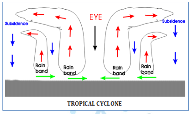
- The eye is a region of calm with subsiding air.
- Around the eye is the eye wall, where there is a strong spiralling ascent of air to greater height reaching the tropopause.
- The wind reaches maximum velocity in this region, reaching as high as 250 km per hour.
- Torrential rain occurs here.
- From the eye wall, rain bands may radiate and trains of cumulus and cumulonimbus clouds may drift into the outer region.
- The diameter of the storm over the Bay of Bengal, Arabian Sea and Indian ocean is between 600 – 1200 km.
- The system moves slowly about 300 – 500 km per day.
- The cyclone creates storm surges and they inundate the coastal low lands.
- The storm peters out on the land.
- Tropical cyclones usually do not occur over the South Atlantic Ocean or South East Pacific (east of 140oW) mainly because of the colder sea surface temperatures (SSTs) and other unfavourable ocean and atmospheric conditions.
FREQUENCY
- About five to six Tropical Cyclones occur in a year over the North Indian Ocean during the pre-monsoon (March-April-May) and post-monsoon (October- November-December) seasons.
- This accounts for about seven per cent of all global Tropical Cyclones.
- The ratio of formation over the Bay of Bengal (BoB) vis-a-vis the Arabian Sea (AS) is 4:1. Globally, the frequency is maximum over the northwest Pacific followed by the north Atlantic Ocean.
- In the North Indian Ocean, the frequency of Tropical Cyclones is bimodal, with primary maxima in the month of November followed by secondary maxima in the month of May.
MOVEMENT
- Tropical Cyclones generally move in a northwesterly direction.
- However, they may sometimes re-curve depending upon atmospheric conditions.
- The Bay of Bengal Tropical Cyclones mainly strike the Odisha-West Bengal coast in October, Andhra coast in November and the Tamil Nadu coast in December.
- Over 50 per cent of the Tropical Cyclones in the Bay of Bengal strike different parts of the eastern coast of India, 30 per cent strike the coasts of Bangladesh, Myanmar and Sri Lanka and about 20 per cent dissipate over the sea.
- The percentage of Tropical Cyclones dissipating over the Arabian Sea is higher (60 per cent) as the western Arabian Sea is cooler. Maximum landfall occurs over the Gujarat coast (18 per cent of the total cyclones in the Arabian Sea) in India, followed by coastal Oman.
LIFE PERIOD
- The life period of a Tropical Cyclone over the North Indian Ocean is 5 – 6 days.
- The VSCS with an intensity 64 knots or more lasts for 2-3 days as against a global average of 6 days.
- There are several stages that comprise the life-cycle of an average Tropical Cyclone.
- These stages are not discrete entities, but represent a continuous process.
- The period from the formation of an initial disturbance or low-pressure area, to its intensification into a depression, a deep depression, and thereon to a cyclonic storm and its ultimate weakening make up the life cycle of a Tropical Cyclone.
- This can be divided into 4 stages-formative, immatu
i. FORMATIVE STAGE
- Since the development of a Tropical Cyclone is a continuous process, features associated with the earliest stages may overlap.
- The formative stage marks the period when an initial low-pressure-disturbance intensifies into a depression, a deep depression and finally into a Tropical Cyclone.
- The pressure falls gradually along with an increase in surface wind speed.
- Clouds and rain associated with the storm occur in a disorganised pattern at this stage.
- The development of marked circular cloud masses also occurs at this stage and lasts a few days.
ii IMMATURE STAGE
- In this stage, two things occur -rapid fall of pressure in the central region of the Tropical Cyclone, and strengthening of winds in the surface circulation.
- At the end of this stage, the lowest pressure and the strongest winds associated with the storm are reached.
- The winds, clouds, and precipitation pattern become more organised, and form spiral bands directed inward.
- This stage lasts for half a day to 2-3 days.
- The duration is dependent upon the ocean basin. For Bay of Bengal and the Arabian Sea, the stage lasts up to a day while for the Atlantic Ocean, it takes 2-3 days.
iii. MATURE STAGE
- In this stage, the system reaches a steady state.
- The central pressure no longer drops and wind strength does not increase.
- However, the circulation expands in area and the size of the system expands horizontally in all directions to reach its maximum size.
- Strong winds extend up to 200 miles from the centre.
- The symmetry in circulation associated with the cyclone is lost and the maximum wind and maximum pressure gradient and concentrated in the right forward sector of the Tropical Cyclone in the northern hemisphere.
- This stage lasts a few days to a week depending on the basin in which it is formed.
iv DECAYING STAGE
- In this stage, the Tropical Cyclone weakens into a depression, and gradually or rapidly subsides depending upon the ocean basin and atmospheric conditions. Dissipation occurs when:
- Landfall results in supply of moisture being cutoff and surface friction increases.
- Tropical Cyclone enters into an area of relatively cold waters which is below 26°C.
- Tropical cyclone remains for too long in the same area of the ocean and upper 100 feet of warmer water mixes with the colder water due to upwelling.
- Entrance of colder and dry air in lower levels of the Tropical cyclone that causes weaker circulation.
- Tropical cyclone experiences a high vertical wind shear and the convective heat engine moves away from the centre, preventing further development.
- Formation of an outer eye wall, typically around 50-100 miles from the centre of the storm, chokes off convection within the inner eye wall. Such weakening is generally temporary unless it meets the other conditions mentioned above. If the outer eye wall merges with the inner eye wall, the tropical cyclone may strengthen.
- Sometimes, if the tropical cyclone meets mid-latitude westerlies, it can turn into an extra-tropical cyclone. When passing over the sub-tropical ridge while moving north or north eastwards, cold air is likely to favour its transformation into an extra-tropical cyclone.
HORIZONTAL STRUCTURE
- Considering the horizontal structure, the tropical cyclone consists of four parts.
- The first is the central part, known as the eye, characterised by calm winds, a clear sky and the lowest pressure.
- Abrupt precipitation is observed when the eye passes over an area.
- The diameter of the eye varies from 10-50 km, which is generally circular, but could be elliptical too.
- It could also be a diffused or have a double eye. Inside the eye, the surface temperatures are slightly higher than the surroundings, and as one moves to the upper level it turns significantly higher.
- The second part is the wall cloud region that is adjacent to the eye-the most dangerous part of a tropical cyclone.
- The width of the wall cloud is about 20-100 km, comprising of huge cumulonimbus clouds.
- The maximum pressure gradient is 0.2-0.5 hPa per km and temperatures are lower than the eye region.
- This region is associated with the heaviest precipitation and strongest winds.
- In some Tropical Cyclones, one might notice double wall cloud regions.
- Herein, one wall cloud region weakens and then, another wall cloud is formed.
- If an existing wall cloud weakens and a double wall cloud forms, the system may be undergoing changes in intensity.
- Normally, in such cases, the intensity may reduce temporarily and would increase again as the two wall clouds merge leading to a single eye.
- The third part is the spiral band of clouds, which extends from the outer region and spirals towards the wall cloud region.
- This area also experiences heavy rainfall and wind speed gradually decreases outward.
- The fourth part is the area from the wall cloud to the outermost region of the tropical cyclone-the outer storm region.
- The wind speed decreases as we move away from the wall cloud, accounting for rainfall of lower intensity as compared to that of the wall cloud region and spiral bands.
VERTICAL STRUCTURE
- A tropical cyclone has three distinct vertical layers- inflow, middle, and outflow.
- The inflow layer is where one sees a flow towards the centre of the tropical cyclone from the outside.
- This layer extends from the surface up to about 3 kms in height.
- The strongest or maximum inflow of winds occurs in the frictional layer, which is layer between the surface to 1 km.
- This layer is also called the planetary boundary layer.
- The diameter of the tropical cyclone remains more or less the same in the inflow layer.
- In the middle layer, the inflow into the centre of the tropical cyclone is compensated by the outflow away from the centre.
- Thus, at any height, there is neither inflow nor outflow. This layer extends from 3 -7.65 km (700 to 400 hPa) above the mean sea level.
- The diameter of the TROPICAL CYCLONE here decreases rapidly with height.
- The outflow layer occurs above 7.65 km. One notices a predominant flow away from the centre.
- Maximum outflow occurs at about 12 km, which again is dependent upon the wind distribution at that level.
- We can also notice the cirrus outflow from tropical cyclone in satellite pictures.
- The diameter of the vortex is small, and is about Plat/long at this level. At times, the cyclonic outflow is visible at this level in intense systems.
- A mature tropical cyclone extends up to about 15 km, with the cyclonic circulation or vortex extending into the entire Troposphere.
- The associated circulation is vertically straight and does not tilt with height. This is because the temperature gradient associated with the tropical cyclone is equal in all directions, preventing a tilt.
- The core is warm as compared to the surrounding regions, with the difference in temperature being around 8OC.
- The maximum warming occurs at the height of 9.5 km.
6.3.2. Formation Of Extra Tropical Cyclones
- The systems developing in the mid and high latitude, beyond the tropics are called the middle latitude or extra tropical cyclones.
- The passage of front causes abrupt changes in the weather conditions over the area in the middle and high latitudes.
- Extra tropical cyclones form along the polar front. Initially, the front is stationary. In the northern hemisphere, warm air blows from the south and cold air from the north of the front.
- When the pressure drops along the front, the warm air moves northwards and the cold air move towards south setting in motion an anticlockwise cyclonic circulation.
- The cyclonic circulation leads to a well-developed extra tropical cyclone, with a warm front and a cold front.
- There are pockets of warm air or warm sector wedged between the forward and the rear cold air or cold sector in plan and cross section of a well-developed cyclone.
- The warm air glides over the cold air and a sequence of clouds appear over the sky ahead of the warm front and cause precipitation.
- The cold front approaches the warm air from behind and pushes the warm air up.
- As a result, cumulus clouds develop along the cold front.
- The cold front moves faster than the warm front ultimately overtaking the warm front.
- The warm air is completely lifted up and the front is occluded and the cyclone dissipates.
- The processes of wind circulation both at the surface and aloft are closely interlinked.
6.3.3. Difference Between Tropical and Extra Tropical Cyclones
- The extra tropical cyclone differs from the tropical cyclone in number of ways.
- The extra tropical cyclones have a clear frontal system which is not present in the tropical cyclones.
- Extra tropical cyclones cover a larger area and can originate over the land and sea. Whereas the tropical cyclones originate only over the seas and on reaching the land they dissipate.
- The extra tropical cyclone affects a much larger area as compared to the tropical cyclone.
- The wind velocity in a tropical cyclone is much higher and it is more destructive.
- The extra tropical cyclones move from west to east but tropical cyclones move from east to west.
| EXTRA TROPICAL CYCLONES AND TROPICAL CYCLONES: A COMPARISON S.No | Temperate Cyclones | Tropical Cyclones |
|---|---|---|
| 1 | They are of much larger horizontal scale 1000-3000 km in diameter while vertically they extend for 10 km. | On horizontal scale, they are of 200-1000 km in diameter and vertically extend for 15 km. |
| 2 | They form over both land and sea. | Form only in tropical regions |
| 3 | Produced largely in winter | Occurred during late summer and autmn when sea temperatures are highest |
| 4 | Shows greater regularity in their formation year afte year. | Do not have any regularity, vary greatly from year to year. |
| 5 | Derive their energy from air mass temperature contrasts | Derive their energy from latent heat of condensation released within the clouds |
| 6 | Isobars are generally V-shaped and weather pattern is discontinuous | Shows symmetrical shapes about the centre of circulation with circular isobars and weather pattern possess no discontinuity and is organised around its central eye. |
| 7 | Have Low pressure gradient | Have steep pressure gradient |
| 8 | Mean wind speed is 10 - 20 ?????1 | Mean wind speed is twice that of temperate cyclones - 30 ?????1 |
| 9 | Direction of wind is rapidly changing at the front; veering and backing takes place. | Wind shifting in tropical cyclones is slow. |
| 10 | Rainfall is slow and continous for many days | Rainfall is violent and torrential, lasting from few hours to few days. |
| 11 | The paths are determined by upper air westerlies and their rate of movement is faster than tropical cyclones | The paths of tropical cyclones are largely controlled by the sub-tropical high pressure areas over oceans. |
| 12 | Forms in mid-latitudes and temperate zones. | Forms only in tropical regions. |
6.4. THUNDERSTORMS AND TORNADOES
- Other severe local storms are thunderstorms and tornadoes.
- They are of short duration, occurring over a small area but are violent.
- Thunderstorms are caused by intense convection on moist hot days.
- A thunderstorm is a well-grown cumulonimbus cloud producing thunder and lightning.
- When the clouds extend to heights where sub-zero temperature prevails, hails are formed and they come down as hailstorm.
- If there is insufficient moisture, a thunderstorm can generate dust storms.
- A thunderstorm is characterised by intense updraft of rising warm air, which causes the clouds to grow bigger and rise to greater height. This causes precipitation.
- Later, downdraft brings down to earth the cool air and the rain.
- From severe thunderstorms sometimes spiralling wind descends like a trunk of an elephant with great force, with very low pressure at the centre, causing massive destruction on its way. Such a phenomenon is called a tornado.
- Tornadoes generally occur in middle latitudes.
- The tornado over the sea is called water sprouts.
- These violent storms are the manifestation of the atmosphere’s adjustments to varying energy distribution.
- The potential and heat energies are converted into kinetic energy in these storms and the restless atmosphere again returns to its stable state.
6.5. FRONTS & FRONTOGENESIS
- When two different air masses meet, the boundary zone between them is called a front.
- The process of formation of the fronts is known as frontogenesis.
There are four types of fronts:
(a) Cold;
(b) Warm;
(c) Stationary;
(d) Occluded
- When the front remains stationary, it is called a stationary front.
- When the cold air moves towards the warm air mass, its contact zone is called the cold front.
- If the warm air mass moves towards the cold air mass, the contact zone is a warm front.
- If an air mass is fully lifted above the land surface, it is called the occluded front.
- The fronts occur in middle latitudes and are characterised by steep gradient in temperature and pressure. They bring abrupt changes in temperature and cause the air to rise to form clouds and cause precipitation.
6.6. FRONTLYSIS
- It means the destruction or dying of a front.
- The process of frontdysis must continue for sometime in order to destroy an existing front.
- Forms in Subtropical High pressure belt.
CONDITIONS
- Divergence of the wind from a point or dilation from a line.
- When the temperature contrast between the adjacent air masses diminishes, the front start decaying.
- Front degenerate in anticyclonic wind shear areas.
6.7. ANTICYCLONES
- These are the opposite of cyclones with high pressure in the centre and the isobars far apart.
- The pressure gradient is gentle and winds are light.
- Anticyclones normally show fine weather and results in clear sky, calm air and high temperatures in summer (but cold in winter).
- In winter, intense cooling of lower atmosphere may result in thick fogs.
- Anticyclonic conditions may last for days or weeks and then fade out quietly.
- Winds in anticyclones blow outwards and are subject to deflection, but they blow in clockwise in the northern hemisphere and anticlockwise in the southern hemisphere.
COMPARISON BETWEEN CYCLONES AND ANTICYCLONES
| CYCLONES | ANTICYCLONES |
|---|---|
| I I. Low pressure in the centre | High pressure in the centre |
| II II. Isobars are close | Isobars are far apart |
| III III. Dull sky, oppressive air and strong winds | Clear sky, calm air |
| IV IV. Winds blow inwards into regions of low pressure in the centre | Winds blow outwards and subjected to deflection |
| V V. Winds circulation in anticlockwise direction in the northern hemisphere and clockwise in the southern hemisphere. | Winds blow in clockwise in the northern hemisphere and anticlockwise in the southern hemisphere. |
7. LOCAL WINDS
7.1. LOCAL WINDS
- Differences in the heating and cooling of earth surfaces and the cycles those develop daily or annually can create several common, local or regional winds.
7.1.1. Land and Sea Breezes
- Land and sea breezes, representing a complete cycle of diurnal winds, are, in fact, monsoon winds at local scale because they change their direction twice in every 24 – hour period.
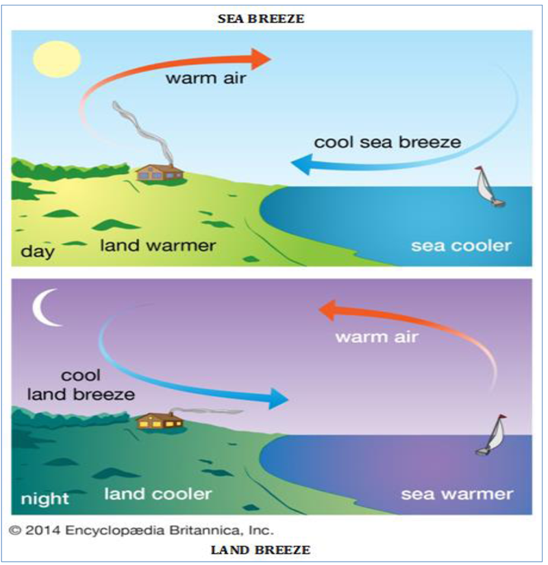
- These local diurnal monsoon winds very commonly known as land and sea breezes are found in the coastal areas wherein sea breeze blows from sea to land, during day time and land breeze moves from land to sea during night due to differential heating and cooling of land and water.
SEA BREEZE
- Sea Breeze – Land is heated more quickly than the adjacent sea during day time, with the result the warm air over the adjacent land expands and thus low pressure is developed while high pressure is developed over adjacent sea.
- The pressure gradient causes circulation of relatively cool air from sea to adjacent land.
- Sea breezes begin to flow usually between 10 – 11 a.m. and become most active in early afternoon usually between 1 – 2 p.m. with maximum velocity ranging between 10 to 20 kilometers per hour and are terminated by 8 p.m. at night.
- The average depth of sea breeze system ranges between 1000 – 2000 metres in the coastal regions of the tropical areas while its depth is between 200 and 500 m near the lakes.
- The cooling effect of sea breezes reaches 50 to 65 km inland in thetropical regions while 15 to 50 km in the middle latitudes.
- The velocity of these winds varies spatially e.g. the velocity varies from 25 to 50 km per hour in the temperate areas while some times sea breezes becomes stormy in the tropical areas.
- Sea breezes have cooling effects on the coastal land as the temperature drops by 50°C to 10°C, with the resulting weather becomes pleasant.
- Sea breezes are most active during summer season.
LAND BREEZE
- After sunset, the sea breezes are weakened because the day time low pressure over land is weakened due to rapid loss of heat through outgoing long wave radiation from the land.
- Consequently, the position of day time high and low pressure is reversed.
- Now high pressure is developed on land against low pressure on the adjacent sea with the result air starts moving from land to sea during night.
- Land breezes are comparatively weaker than sea breezes. These are dry winds.
7.1.2. Mountain and Valley Breezes
- Mountain and valley breezes also known as up valley (during daytime) and down valley (during night) breezes are, in fact, local as well as diurnal (periodic winds-the directions of which are reversed during 34 hours).
- The slopes and valley floors in the mountainous regions are more heated through insolation during daytime than the free atmosphere at the same elevation.
- Consequently, the warm air moves upslope (upward).
- This upslope moving breeze during mountains and thus are cooled at the dry adiabatic rate of 5.5°F 1000 feet (10°C per 1000 metres).
- These winds after reaching higher height become saturated (due to lowering of temperature and hence increase of relative humidity) and yield precipitation.
- The latent heat of condensation released after precipitation is added to daytime is called valley breeze.
- Valley breezes reach mountain peaks and yield precipitation through cumulus clouds.
- The valley slopes and upper parts are cooled due to loss of heat through outgoing long wave radiation and thus cool air descends through outgoing longwave radiation and thus cool air descends through the valley slopes.
- Such wind is called downvalley or mountain breeze.
- The mountain breezes cause inversion of temperature in the valleys.
- Hence the valley floors are characterized by frost during night while the upper parts are free from frost in cold areas.
7.1.3. Chinook and Foehn
- Warm and dry local winds blowing on the leeward sides of the mountains are called chinook in the USA and foehn in Switzerland.
- These local vertical winds are of cyclonic origin and largely influence the weather conditions of the affected areas locally.
- The winds associated with the cyclones after descending through the eastern slopes of the Rockies become warm and dry and thus give birth to chinook.
- The winds ascend through the western slopes of the Rockies the ascending winds, with the result the temperature of the ascending winds decreases at the moist adiabatic rate of 3° F per 1000 feet.
- The westerly winds after crossing over the Rockies descend through the eastern slopes and thus are heated at the dry adiabatic rate of 5.5°F per thousand feet.
- These warm and dry winds after reaching the foothill zones of the eastern slopes of the Rockies are called Chinook.
- Chinook winds are more common during winter and early spring along the eastern slopes (leeward side) of the Rocky Mountains from Colorado (USA) in the south of British Columbia (Canada) in the north.
- Normally, the actual temperature of chinook is 40°F (4.4°C) after the arrival of chinooks within 24 hours is not unusual.
- Sometimes, temperature rises by 30° to 40° F within few minutes.
- Thus, snow present on the ground surface melts away due to sudden rise in temperature as if by magic. This is why chinook is also called as ‘snow eater’.
- This is the impact of chinooks that green pastures are open in a narrow strip along the eastern slopes of the Rockies even during winter season.
- The rise in temperature due to chinooks also helps in early sowing of spring wheat in the USA.
- A warm and dry wind similar to chinook is called ‘foehn’ along the northern slopes of the Alps mountains.
- These are more common during spring and autumn in Switzerland.
- The weather becomes quite pleasant in the valleys due to melting of snow because of increase in temperature by 40°F after the arrival of foehn winds.
- Hence valleys of Switzerland are called ‘climatic oasis’ during winter season. These winds help in early sowing of spring wheat, ripening of grapes and check autumn frost.
7.1.4. HARMATTAN
- The warm and dry winds blowing from northeast and east to west in the eastern parts of Sahara desert are called Harmattan.
- These winds become extremely dry because of their journey over Sahara desert.
- While blowing over Sahara desert these winds pick up more sands mainly red sands.
- The western coast of Africa is warm and moist and hence the weather becomes unpleasant because the weather conditions characterized by high temperature and high relative humidity become injurious for human health.
- The weather becomes suddenly dry and pleasant at the arrival of harmattan as the relative humidity of the air is remarkably reduced due to high temperature and hyper aridity of harmattan.
- This is why harmattan is known as ‘doctor’ in the Guinea coastal area of western Africa.
- Harmattan is very dusty and stormy wind blowing with so gusty speed that trees are up-rooted. These winds are usually associated with dust storms resulting into marked reduction in the visibility.
- Harmattan becomes more vigorous during summer months and is a special type of northeast trade wind.
- It becomes extremely warm wind because of hot and dry desert of Sahara.
- Similar warm, dry, very strong and dust – laden winds are called ‘brickfielder’ in victoria province of Australia, ‘blackroller’ in the Great Plains of the USA, ‘shamal’ in Mesopotamia and Persian Gulf, and ‘norwester’ in New Zealand.
7.1.5. SIROCCO
- Sirocco is a warm, dry and dusty (full of sands) local wind which blows in northerly direction from Sahara Desert and after crossing over the Mediterranean Sea reaches Italy, Spain etc.
- Sirocco becomes very strong and active at the time of the origin of cyclonic storms and active at the time of the origin of cyclonic storms and active at the time of the origin of cyclonic storms over the Mediterranean Sea.
- It becomes extremely warm and dry while descending through the northern slopes of the Atlas Mountain.
- There are different local names for sirocco in Africa e.g. khamsin in Egypt (UAR), gibli in Libya, chilli in Tunisia etc.
- The warm and dry dusty winds in the Arabian Desert are called ‘simoom’.
- Sirocco, while passing over the Mediterranean Sea picks up moisture and yields rainfall in the southern part of Italy where the rain associated with sirocco is called ‘blood rain’ because of fallout of red sands with falling rains.
- Sirocco, while blowing through Sahara Desert picks up red sands which settle down with rains in south Italy. It is apparent that sirocco is very much injurious to agricultural and fruit crops.
7.1.6. MISTRAL
- Mistral is a cold local wind which blows in Spain and France from northwest to southeast direction.
- These winds are more common and effective during winter season because of development of high pressure over Europe and low pressure over Mediterranean Sea.
- They become extremely cold when they blow through central plateau and descend into Rhone valley on the southern coast of France.
- While blowing through the narrow valley of Rhone they become stormy northerly cold winds.
- The average velocity of mistral is 56 – 64 km per hour but sometimes it becomes 128 km per hour. These stormy winds adversely affect air flights • The arrival of mistral causes sudden drop in air temperature to below freezing point.
7.1.7. BORA
- Bora is an extremely cold and dry north easterly wind which blows along the shore of the Adriatic Sea.
- Bora becomes more effective in north Italy where it descends through the southern slopes of the Alps and blow in southerly direction.
- The velocity of bora ranges between 128 Km and 196 Km an hour.
- Unlike mistral, bora is relatively moist wind because it picks up moisture while coming from over the Adriatic Sea.
7.1.8. BLIZZARD
- Blizzard is a violent storm cold and powdery polar wind laden with dry snow and is prevalent in north and south Polar Regions, Siberia, Canada and the USA.
- The visibility becomes remarkably low because of snow and ice crystals.
- The velocity ranges between 80-96 km an hour.
- The arrival of these winds causes sudden drop in air temperature to subfreezing level, thick cover of snow on the ground surface and onset of cold waves.
- These winds reach the southern states of the USA because of the absence of any east – west mountain barrier. They are called ‘norther’ in the southern USA and ‘burran’ in Siberia.
7.2. LOCAL WINDS:
These winds blow with some special characteristics over a small area and last for a short period. All these winds are mostly seasonal and given local names.
| Name | Location | Characteristics |
|---|---|---|
| Loo | Northern Indian Plains | Hot and dry, Dust storm It can be fatal. |
| Period: May to June | ||
| Chinook means Snow eater | Wind ward and leeward side of Rocky mountains | Warm and moist wind. Gives rain and snow to windward side of Rocky mountains. Melts snow in the leeward side of Rockies. |
| Foehn | Alps of Europe | Similar to Chinook in character |
| Berg | Off the South African plateau | Similar to Chinook in character |
| Santa Ana | Southern California | Hot dry descending winds. They may even cause fires in the dry areas. |
| Mistral | Shores of north-west Mediterranean in France | Cold dry winds |
| Bora | Shores of north-west Mediterranean in Italy | Cold dry winds |
| Leveche | Spain | Furious warm wind |
| Sirocco | Northern Africa, Southern Sicily | Hot and dry wind originating in the Sahara desert and blows through the Mediterranean sea to reach Sicily. Rainfall brought by these winds are usually brown in color (due to desert sand and dust in air) It is called Blood Rain. |
| Norwesters (In Bengal it is called kalbaisaki) | Bengal and Assam | Violent thunder storms during April to June, before the onset of South-West monsoon. It is the rain from these winds that sustains the tea plants even in hot season. |
| Brick Fielder | Australia | Warm Wind |
| Harmattan | Central Africa | Warm Wind |
| Purga | Russia | Cold Wind |
| Norte | Gulf of Mexico | Cold Wind |
| Pampero | Argentina | Cold Wind |
8. CLOUDS
8.1. CLOUDS – INTRODUCTION
- Cloud is a mass of minute water droplets or tiny crystals of ice formed by the condensation of the water vapour in free air at considerable elevations.
- As the clouds are formed at some height over the surface of the earth, they take various shapes.
- Clouds are also defined as aggregates of innumerable tiny water droplets, ice particles or mixture of both in the air generally above the ground surface.
- Clouds are formed due to condensation of water vapour around hygroscopic nuclei caused by cooling due to lifting of air generally known as adiabatic cooling.
- Meteorologically clouds are very significant because all forms of precipitation occur from them.
- Clouds play major role in the heat budget of the earth and the atmosphere as they reflect, absorb and diffuse some part of incoming shortwave solar radiation and absorb some part of outgoing longwave terrestrial radiation and then reradiate it back to the earth’s surface.
8.2. CLASSIFICATION OF CLOUDS
- According to their height, expanse, density and transparency or opaqueness clouds are grouped under four types (i) cirrus; (ii) cumulus; (iii) stratus; (iv) nimbus.
- A combination of these four basic types can give rise to the following types of clouds: High clouds – cirrus, cirrostratus, cirrocumulus;
Middle clouds – altostratus and altocumulus;
Low clouds – stratocumulus and nimbostratus and
Clouds with extensive vertical development – cumulus and cumulonimbus.
- There is wide range of variations in clouds in terms of height, shape, colour, and transmission or reflection of light.
8.2.1. CIRRUS CLOUDS
- Cirrus clouds are formed at high altitudes (8,000 – 12,000m).
- This high altitude detached clouds having fibrous (hair like) or silky appearance are called cirrus clouds.
- They are thin and detached clouds having a feathery appearance.
- They are composed of tiny ice crystals and are transparent and white in colour but have brilliant colours at sunset and sunrise.
- These clouds are indicative of dry weather.
8.2.2. CIRRO – CUMULUS CLOUDS
- These are white coloured clouds having cirriform layer or patches of small white flakes or small globules which are arranged in distinct groups, or wavelike form.
- They generally appear as ripples similar to sand ripples in the desert.
- These are not common type of clouds.
8.2.3. CIRRO – STRATUS CLOUDS
- These are generally white in colour and spread in the sky like milky thin sheets.
- In fact, cirro – stratus is a thin white veil of cirrus clouds.
- They are composed of tiny ice crystals which refract the lights of the sun and moon and thus halos are formed around them (around sun and moon).
- They are so transparent that the sun and moon are visible through them.
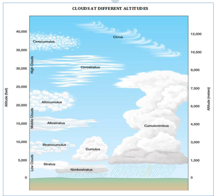
8.2.4. ALTO – STRATUS CLOUDS
- These are thin sheets of grey or blue colour having fibrous or uniform appearance.
- When they become thick sheets the sun and moon are obscured and they appear as bright spots behind the clouds.
- They do not form halos around the sun and moon.
- They cover the sky partly or totally or are smoothly distributed over the entire sky.
- The yield widespread continued precipitation either in the form of drizzle or snow.
8.2.5. ALTO – CUMULUS CLOUDS
- These are characterized by wavy layers of globular form.
- They form fairly regular patterns of lines, groups or waves.
- In fact, they are individual masses of clouds which are fitted closely together in geometrical patterns.
- High globular groups of alto – cumulus are sometimes called as sheep clouds or wool pack clouds.
- They appear white or grey in colour.
8.2.6. NIMBO – STRATUS CLOUDS
- These are low clouds of dark colour very close to the ground surface.
- They are so compact and thick (hundreds of metres) that there is complete darkness and there is copious precipitation.
- Nimbo is from Latin word ‘nimbus’ meaning thereby rainstorm.
- They are associated with rain, snow and sleet but are not accompanied by lightning, thunder or hailstorm.
8.2.7. STRATO – CUMULUS CLOUDS
- These are of grey or white in colour.
- They are found in rounded patches between the height of 2500m to 3000m.
- They are composed of globular masses or rolls which are generally arranged in lines, waves or groups and associated with fair or clear weather but occasional rain or snow is not ruled out.
8.2.8. STRATUS CLOUDS
- As their name implies, these are layered clouds covering large portions of the sky.
- These are dense, low lying fog – like clouds of dark grey colour but are not close to the ground surface.
- They are composed of several uniform layers.
- These clouds are generally formed either due to loss of heat or the mixing of air masses with different temperatures.
- When these clouds are associated with rains or snow, they are called nimbostratus clouds as referred to above.
8.2.9. CUMULUS CLOUDS
- Cumulus clouds look like cotton wool.
- They are generally formed at a height of 4,000 – 7,000 m.
- They exist in patches and can be seen scattered here and there.
- They have a flat base and are very dense widespread and dome – shaped and have flat bases.
- They are associated with fair weather but sometimes they become thunder clouds.
8.2.10. CUMULO – NIMBUS CLOUDS
- These are thunder – storm clouds.
- They show great vertical development and produce heavy rains, snow or hailstorm
accompanied by lightning, thunder and gusty winds.
NIMBUS
- Nimbus clouds are black or dark grey.
- They form at middle levels or very near to the surface of the earth.
- These are extremely dense and opaque to the rays of the sun.
- Sometimes, the clouds are so low that they seem to touch the ground.
- Nimbus clouds are shapeless masses of thick vapour.
JET STREAM
9.1. INTRODUCTION – JETSTREAM
- The strong and rapidly moving circumpolar westerly air circulation in a narrow belt of a few hundred kilometers width in the upper limit of troposphere is called jet stream.
- The circulation of westerly jet stream is confined between poles and 20° latitudes in both the hemispheres at the height of 7.5 – 14 km.
- According to World Health Organization (WHO), ‘a strong narrow current concentrated along a quasihorizontal axis in the upper troposphere or in the stratosphere characterized by strong vertical and lateral wind shear and featuring one or more velocity maxima is called jet stream’.
9.2. PROPERTIES
The jet streams are characterized by the following properties.
i) The circulation of jet stream is from west to east in a narrow belt of a few hundred kilomerters width at the height of 7.5 – 14 km in the upper troposphere.
II )On an average, jet steams measure thousands of kilometers in length, a few hundred kilometers in width and few kilometers (2 – 4 km) depth.
iii) Generally, their circulation is observed between poles and 20° latitude in both the hemispheres. These are also called circum – polar whirl because these move around the poles in both the hemispheres.
iv} The vertical wind shear of jet streams is 5 – 10m/second (18 -36km/hour), meaning thereby the wind velocity above or below jet stream decreases by 18 -36 km/hour. Lateral wind shear is 5m/second (18km/hour). The minimum velocity of jet stream is 30m/second (108 km/hour).
v) Their circulation path (trajectory) is wavy and meandering.
vi) There is seasonal change in the wind velocity in jet streams wherein these become strong during winter season and the wind velocity becomes twice the velocity during summer season. (Maximum wind velocity is 480 km per hour).
vii. The extent of jet streams narrows down during summer season because of their northward sifting while these extend up to 20° latitudes during winter season.
DISCOVERY OF JET STREAM
Jet steam was discovered during second world war when American jet bomber fighter planes while flying towards Japan (from east to west) found obstructions of an air circulation which was moving in opposite direction (West to east) resulting into marked reduction in the velocity of jet fighter planes, these planes registered marked increase in their velocity while they used to return to their bases (west to east). After careful study of this phenomenon, it was found that there was a strong upper air circulation from west to east in the upper portion of troposphere which presented obstruction in the free movement of jet fighter planes. Based on this fact, westerly strong meandering upper air circulation was called as jet stream.
9.3. TYPES OF JET STREAMS
On the basis of locational aspect, jet streams are divided into 5 types:
(1) Polar front jet streams are formed above the convergence zone (40 -60 latitudes) of the surface polar cold air mass and tropical warm air mass. The thermal gradient is steepened because of convergence of two contrasting air masses. These move in easterly direction but are irregular.
(2) Subtropical westerly jet streams move in the upper troposphere to the north of subtropical surface high pressure belt (at the poleward limit of the Hadley cell in both the hemispheres) i.e. above 30 °−35° latitudes. Their circulation is from west to east in more regular manner than the polar front jet streams.
(3) Tropical easterly jet stream develop in the upper troposphere above surface easterly trade winds over India and Africa during summer season due to intense heating of Tibetan plateau and play important role in the mechanism of Indian monsoon.
(4) Polar night jet streams, also known as stratospheric subpolar jet streams, develop in winter season due to steep temperature gradient in the strato-sphere around the poles at the height of 30 km. These jet streams become very strong westerly circulation with high wind velocity during winters but their velocity decreases during summers and the direction becomes easterly.
(5) Local jet streams are formed locally due to local thermal and dynamic conditions and have limited local importance.
9.4. INDEX CYCLES OF JET STREAMS
- The genesis of jet streams is related to temperature gradient fromequator towards the poles, surface high pressure at the poles and genesis of circumpolar whirl above the poles caused by tropospheric low pressure.
- Surface high pressure is intensified over the surface of arctic region due to subsidence of cooled heavy air during winter season in the northern hemisphere.
- On the other hand, upper air low pressure develops in the upper troposphere above the high pressure of ground surface of the arctic region.
- Due to this phenomenon a cyclonic system (west to east) of air circulation in the form of a whirl develops around upper tropospheric low pressure.
- The general direction of this circulation is form of a whirl develops around upper tropospheric low pressure.
- The general direction of this circulation is from west to east.
- The equatorward meandering part of this upper air circulation is called jet stream.
- The upper air arctic whirl becomes very strong during winter season in the northern hemisphere resulting into maximum southward extension of jet stream upto 20°N latitude.
- There are changes in the position of extent of jet stream from poles toward equator.
- The weavy (meandering) jet stream is called rossby waves.
- The period of transformation of straight path of jet stream to wavy or meandering path is called index cycle which is completed in four successive stages.
FIRST STAGE
- The position of stream is near the poles and is separated by polar cold air mass in the north and warm westerlies in the south (in Northern hemisphere).
- The circulation of jet stream is almost in straight path from west to east because Rossby wave is not developed by this time. There is step pressure gradient across this strong upper air westerly circulation which generates high zonal index.
SECOND STAGE
- Gradually, the straight path of jet stream is transformed into wavy path with March of time.
- This process initiates the beginning of the development of Rossby waves.
- With the march of time, the amplitude of jet streams increases and gradually they extend towards the equator.
- The pressure gradient is north-south.
THIRD STAGE
- It is characterized by fully developed meandering course of jet stream, with the result they are positioned near the equator (20° latitude).
- The pressure gradient in the first two stages is from north to south, but here east-west.
- There is displacement of polar cold air masses towards equator and tropical warm air masses towards the poles.
FOURTH STAGE
- Fourth stage is characterized by cutting off meanders of jet stream from main path due to their more and more meridional circulation (north to south) resulting into their circulation in independent circular pattern in the form of cyclonic and Anticyclonic circulation.
- Thus, there develop several cellular circulation patterns which follow cyclonic pattern in the south and Anticyclonic pattern in the north.
- Such cut off low (cyclonic) or cut off high (anticyclonic) air circulation patterns obstruct west to east flow of jet streams.
9.5. SIGNIFICANCE OF JET STREAMS
Though jet streams have not been properly studied as yet but they are supposed to have immense influence on local and regional weather conditions as follows:
(1) There is close relationship between the intensity of mid-latitude (temperate) cyclones and jet
streams. These cyclones become very strong and stormy when the upper air tropospheric jet streams are positioned above temperate cyclones of ground surface and yield more precipitation than normal.
(2) There are fluctuations in the local weather conditions due to changes in the form and nature of ground surface cyclones and anticyclones caused by upper air jet streams.
(3) Jet streams cause horizontal convergence and divergence in the upper troposphere. The upper air convergence forms upper air anticyclones while upper air cyclones are developed due to upper air divergence.
(4) The vertical circulation of air in jet streams occurs in 2 ways. E.g. cyclonic pattern characterized by upward vertical air movement while there is downward vertical air movement in Anticyclonic pattern of air circulation. This vertical air circulation causes rapid rate of mixing of air between troposphere and stratosphere, which helps in transport of anthropogenic pollutants from troposphere to stratosphere. For e.g. the transport of CFC into stratosphere.
(5) The monsoon of South Asia is largely affected and controlled by jet streams
The pressure gradient in the first two stages is from north to south, but here east-west.There is displacement of polar cold air masses towards equator and tropical warm air masses towards the poles.
TYPES OF PRECIPITATION
10.1. WATER IN ATMOSPHERE
- The air contains water vapour.
- It varies from zero to four per cent by volume of the atmosphere and plays an important role in the weather phenomena.
- Water is present in the atmosphere in three forms namely – gaseous, liquid and solid.
- The moisture in the atmosphere is derived from water bodies through evaporation and from plants through transpiration.
- Thus, there is a continuous exchange of water between the atmosphere, the oceans and the continents through the processes of evaporation, transpiration, condensation and precipitation.
10.2. HUMIDITY
- Water vapour present in the air is known as humidity.
- It is expressed quantitatively in different ways.
- The actual amount of the water vapour present in the atmosphere is known as the absolute humidity. It is the weight of water vapour per unit volume of air and is expressed in terms of grams per cubic metre.
- The ability of the air to hold water vapour depends entirely on its temperature.
- The absolute humidity differs from place to place on the surface of the earth.
- The percentage of moisture present in the atmosphere as compared to its full capacity at a given temperature is known as the relative humidity.
- With the change of air temperature, the capacity to retain moisture increases or decreases and the relative humidity is also affected.
- It is greater over the oceans and least over the continents.
- The air containing moisture to its full capacity at a given temperature is said to be saturated.
- It means that the air at the given temperature is incapable of holding any additional amount of moisture at that stage.
10.3. DEW POINT
- The temperature at which saturation occurs in a given sample of air is known as dew point.
10.4 EVAPORATION
- The amount of water vapour in the atmosphere is added or withdrawn due to evaporation and condensation respectively.
- Evaporation is a process by which water is transformed from liquid to gaseous state.
- Heat is the main cause for evaporation.
- The temperature at which the water starts evaporating is referred to as the latent heat of vapourisation.
- Increase in temperature increases water absorption and retention capacity of the given parcel of air.
- Similarly, if the moisture content is low, air has a potentiality of absorbing and retaining moisture.
- Movement of air replaces the saturated layer with the unsaturated layer. Hence, the greater the movement of air, the greater is the evaporation.
10.5. CONDENSATION
- The transformation of water vapour into water is called condensation.
- Condensation is caused by the loss of heat.
- When moist air is cooled, it may reach a level when its capacity to hold water vapour ceases.
- Then, the excess water vapour condenses into liquid form.
- In free air, condensation results from cooling around very small particles termed as hygroscopic condensation nuclei.
- Particles of dust, smoke and salt from the ocean are particularly good nuclei because they absorb water.
- Condensation also takes place when the moist air comes in contact with some colder object and it may also take place when the temperature is close to the dew point.
- Condensation, therefore, depends upon the amount of cooling and the relative humidity of the air. Condensation is influenced by the volume of air, temperature, pressure and humidity.
Condensation takes place:
- when the temperature of the air is reduced to dew point with its volume remaining constant;
- when both the volume and the temperature are reduced;
iii. when moisture is added to the air through evaporation.
However, the most favourable condition for condensation is the decrease in air temperature.
- After condensation the water vapour or the moisture in the atmosphere takes one of the following forms — dew, frost, fog and clouds.
- Forms of condensation can be classified on the basis of temperature and location.
- Condensation takes place when the dew point is lower than the freezing point as well as higher than the freezing point.
10.6. FORMS OF CONDENSATION
i DEW
- When the moisture is deposited in the form of water droplets on cooler surfaces of solid objects (rather than nuclei in air above the surface) such as stones, grass blades and plant leaves, it is known as dew.
- The ideal conditions for its formation are clear sky, calm air, high relative humidity, and cold and long nights.
- For the formation of dew, it is necessary that the dew point is above the freezing point.
ii .FROST
- Frost forms on cold surfaces when condensation takes place below freezing point (00C), i.e. the dew point is at or below the freezing point.
- The excess moisture is deposited in the form of minute ice crystals instead of water droplets.
- The ideal conditions for the formation of white frost are the same as those for the formation of dew, except that the air temperature must be at or below the freezing point.
iii. FOG
- When the temperature of an air mass containing a large quantity of water vapour falls all of a sudden, condensation takes place within itself on fine dust particles.
- So, the fog is a cloud with its base at or very near to the ground.
- Because of the fog and mist, the visibility becomes poor to zero. In urban and industrial centres smoke provides plenty of nuclei which help the formation of fog and mist.
- Such a condition when fog is mixed with smoke, is described as smog.
iv. MIST
- The only difference between the mist and fog is that mist contains more moisture than the fog.
- In mist each nuclei contains a thicker layer of moisture.
- Mists are frequent over mountains as the rising warm air up the slopes meets a cold surface.
- Fogs are drier than mist and they are prevalent where warm currents of air come in contact with cold currents.
- Fogs are mini clouds in which condensation takes place around nuclei provided by the dust, smoke, and the salt particles.
10.7. FORMS OF PRECIPITATION
10.7.1. Precipitation
- The process of continuous condensation in free air helps the condensed particles to grow in size.
- When the resistance of the air fails to hold them against the force ofgravity, they fall on to the earth’s surface.
- So after the condensation of water vapour, the release of moisture is known as PRECIPITATION.
- This may take place in liquid or solid form.
- The precipitation in the form of water is called RAINFALL, when the temperature is lower than the 0°C, precipitation takes place in the form of fine flakes of snow and is called Snowfall.
- Moisture is released in the form of hexagonal crystals. These crystals form Flakes of Snow.
- Besides rain and snow, other forms of precipitation are Sleet and Hail, though the latter are limited in occurrence and are sporadic in both time and space.
- Sleet is frozen raindrops and refrozen melted snow-water. When a layer of air with the temperature above freezing point overlies a subfreezing layer near the ground, precipitation takes place in the form of sleet.
- Raindrops, which leave the warmer air, encounter the colder air below. As a result, they solidify and reach the ground as small pellets of ice not bigger than the raindrops from which they are formed.
- Sometimes, drops of rain after being released by the clouds become solidified into small rounded solid pieces of ice and which reach the surface of the earth are called hailstones. These are formed by the rainwater passing through the colder layers. Hailstones have several concentric layers of ice one over the other.
10.7.2. Types of Rainfall
On the basis of origin, rainfall may be classified into three main types – the convectional, orographic or Relief and the Cyclonic or frontal.
10.7.2.1. Convectional Rain
-
- When the earth’s surface is heated by conduction, moisture laden vapour rises because heated air always expands and becomes lighter.
- Air rises in a convectional current after a prolonged period of intense heating.
- In ascending, condensation of water vapour takes place and cumulonimbus clouds are formed with huge vertical extent.
- This reaches its maximum in the afternoon, when the convectional system is well formed.
- Hot, rising air has great capacity for holding moisture, which is abundant in regions of high relative humidity.
- As the air rises, it cools and when saturation point is reached, torrential downpours occur with thunder and lightning. (Heavy rainfall takes place but this does not last long).
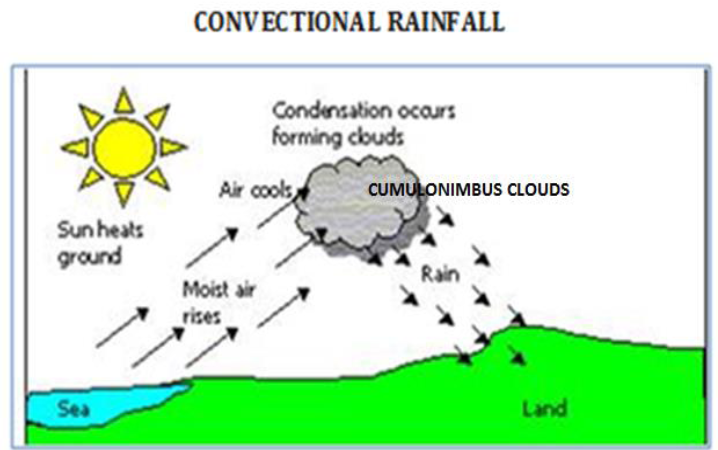
- Such rain is common in the summer or in the hotter part of the day.
- This type of rainfall is most common in regions that are intensely heated (day time in tropics and summer season in temperate region interiors).
- Therefore, it is very common in the equatorial regions and interior parts of the continents, particularly in the northern hemisphere.
10.7.2.2. OROGRAPHIC RAIN
- When the saturated air mass comes across a mountain, it is forced to ascend and as it rises, it expands; the temperature falls, and the moisture is condensed.
- The chief characteristic of this sort of rain is that the windward slopes receive greater rainfall.
- After giving rain on the windward side, when these winds reach the other slope, they descend, and their temperature rises.
- Then their capacity to take in moisture increases and hence, these leeward slopes remain rainless and dry.
- The area situated on the leeward side, which gets less rainfall is known as the rain-shadow area.
- Since it is caused by relief of the land, it is also known as the relief rain.
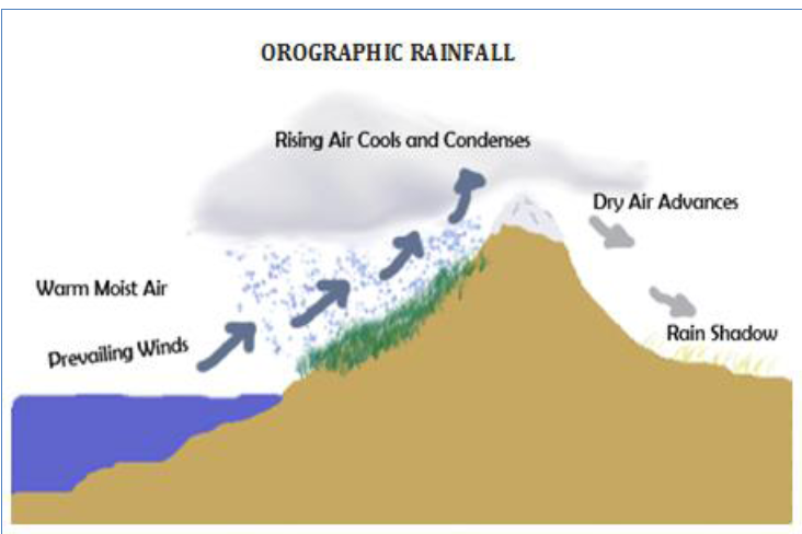
SIGNIFICANT WINDWARD REGIONS
Windward slopes of west Malaysia, western New Zealand, western Scotland and Wales and Assam hills of the Indian subcontinent.
SIGNIFICANT LEEWARD REGIONS
Rain shadow Canterbury plain of New Zealand, Western slopes of Northern and Central Andes.
10.7.2.3. CYCLONIC RAIN
- This type of rainfall is independent of relief or convection and it is purely associated with cyclonic activity in temperate regions (depressions) and tropical regions (cyclones).
- Basically it is due to convergence of two different air masses with different temperatures and other physical properties.
- As cold air is denser, it tends to remain close to the ground and as the warm air is lighter and tends to rise over the cold air.
- In ascent, pressure decreases, the air expands and cools condensation takes place and light showers called Cyclonic or Frontal rain occur.
- The heavier and colder air masses eventually push up the warmer and lighter air and the sky is clear again.
10.7.3. WORLD DISTRIBUTION OF RAINFALL
- Different places on the earth’s surface receive different amounts of rainfall in a year and that too in different seasons.
- In general, as we proceed from the equator towards the poles, rainfall goes on decreasing steadily.
- The coastal areas of the world receive greater amounts of rainfall than the interior of the continents.
- The rainfall is more over the oceans than on the landmasses of the world because of being great sources of water.
- Between the latitudes 35° and 40° N and S of the equator, the rain is heavier on the eastern coasts and goes on decreasing towards the west.
- But, between 45° and 65° N and S of equator, due to the westerlies, the rainfall is first received on the western margins of the continents and it goes on decreasing towards the east.
- Wherever mountains run parallel to the coast, the rain is greater on the coastal plain, on the windward side and it decreases towards the leeward side.
- The equatorial belt, the windward slopes of the mountains along the western coasts in the cool temperate zone and the coastal areas of the monsoon land receive heavy rainfall of over 200 cm per annum.
- Interior continental areas receive moderate rainfall varying from 100 – 200 cm per annum. The coastal areas of the continents receive moderate amount of rainfall.
- The central parts of the tropical land and the eastern and interior parts of the temperate lands receive rainfall varying between 50 – 100 cm per annum.
- Areas lying in the rain shadow zone of the interior of the continents and high latitudes receive very low rainfall-less than 50 cm per annum.
- Seasonal distribution of rainfall provides an important aspect to judge its effectiveness. In some regions rainfall is distributed evenly throughout the year such as in the equatorial belt and in the western parts of cool temperate regions.
10.8. OTHER FORMS OF PRECIPITATION
i. SNOWFALL
- The fall of larger snowflakes from the clouds on the ground surface is called snowfall.
- In fact, snowfall is ‘precipitation of white and opaque grains of ice’.
- The snowfall occurs when the freezing level is so close to the ground surface (less than 300m from the surface) that aggregations of ice crystals reach the ground without being melted in a solid form of precipitation as snow.
ii. SLEET
- Sleet refers to a mixture of snow and rain but in American terminology sleet means falling of small pellets of transparent or translucent ice having a diameter of 5 mm or less.
iii. HAIL
- Hail consists of large pellets or spheres of ice. Hail is a form of solid precipitation wherein small balls or pieces of ice, known as hailstones, having a diameter of 5 to 50mm fall downward known as hailstorms.
- Hails are very destructive and dreaded form of solid precipitation because they destroy agricultural crops and claim human and animal lives.
iv .DRIZZLE
- Drizzle – The fall of numerous uniform minute droplets of water having diameter of less than 0.5 mm is called drizzle.
- Drizzles fall continuously from low stratus clouds but the total amount of water received on the ground surface is significantly low
11. WORLD CLIMATIC REGIONS
It is necessary to divide the world into several climatic zones, each with its own climatic characteristics, natural
World Climatic Types
| Climatic Zone | Latitude | Climatic Type | Rainfall Regime | Natural Vegetation |
|---|---|---|---|---|
| Equatorial Zone | (approximate) 00-100N and S | Hot, wet equatorial | (with approx, total Rainfall all year round: 80 inches | Equatorial rain forests |
| Hot zone (Tropical zone) | 100-300N and S | (a) Tropical Monsoon | Heavy summer rain: 60 inches Much summer rain: 70 inches | Monsoon forests |
| (b) Tropical Marine | ||||
| Sudan Type | Rain mainly in summer: 30 inches | Savanna (tropical grassland) | ||
| Desert: | Little rain : 5 inches | Desert vegetation and scrub | ||
| (a) Saharan type | ||||
| (b) Midlatitude | ||||
| type | ||||
| Warm Temperate Zone | 300-450N and S | Western Margin (Mediterranean type) | Winter rain: 35 inches | Mediterranean forests and shrub |
| Central Continental (Steppe type) | Light summer rain: 20 inches | Steppe or temperate grassland | ||
| Eastern Margin: | Heavier summer rain: 45 inches | Warm, wet forests and bamboo | ||
| (a) China type | ||||
| (b) Gulf type | ||||
| (c) Natal type |
| Cool Temperate Zone | 450-650N and S | Western Margin (British type) | More rain in autumn and winter: 30 inches | Deciduous forests |
|---|---|---|---|---|
| Central Continental (Siberian type) | Light summer rain: 25 inches | Evergreen coniferous forests | ||
| Eastern Margin: (Laurentian type) | Moderate summer rain: 40 inches | Mixed forests (coniferous and deciduous) | ||
| Cold Zone | 650-900N and S | Arctic or Polar | Very light summer rain: 10 inches | Tundra, mosses, lichens |
| Alpine Zone | Mountain climate | Heavy rainfall (variable) | Alpine pastures, conifers, fern, snow |
11.1. THE HOT, WET EQUATORIAL CLIMATE (OR) TROPICAL
RAINFOREST CLIMATE
Distribution: The equatorial hot, wet climate is found between 5o and 10o North and south of the equator along the eastern margin of continents this climatic types also extends to 15o latitude. Its greatest extent is found in the lowlands of the Amazon River basin in the Congo River basin and Guinea coast in Africa Malaysia and the East Indies.
Climate:
Temperature:
- The most outstanding feature of the equatorial climate is its great uniformity of temperature throughout the year.
- The mean monthly temperatures are always around ____ with very little variation
- There is no winter
- The mid- day sun is always overhead, so that the days and nights are always of equal length.
- Cloudiness and heavy precipitation help to moderate the daily temperature
- The annual range of temperature in these regions is very small, hardly more than 2o to 3oc.
- The diurnal range of temperature is also low in this climate. but it is far greater than the annual Lange. it varies from 5oc to 14oc.
PRESSURE AND WINDS:
- The equatorial regions lie in a belt of calm where the winds are light and variable.
- The temperatures being uniformly high throughout the year, these regions are characterised by low
- The temperatures being uniformly high throughout the year, these regions are characterised by low temperature gradients, which produce a feeble pressure gradient resulting in very slight wind movement. The pressure gradient decreases towards the central parts of these regions until there is an area of calm.
PRECIPITATION:
- Precipitation is heavy, between 200cm and 300cm, and well distributed throughout the year.
- There is no month without rain, and a distinct dry season. Instead, there are two periods of maximum rainfall, in April and October, of maximum rainfall, in April and October, which occur shortly after the equinoxes.
- Least rainfalls at the June and December solstices’. The double rainfall peaks coinciding with the equinoxes are a characteristic feature of equatorial climates not found in any other type of climate.
- It is noteworthy that over the oceans, where there is greater supply of moisture, the rainfall tends to be greater than over the land areas.
- Due to the great heat in the equatorial belt, mornings are bright and sunny.
- Most of the annual rainfall in the equatorial region is received in the form of convectional rainfall which occurs in the afternoons from the towering cumulo nimbus clouds. Thunder and lightning often accompany the torrential showers.
- The strong daily vertical convective mechanism due to intense heating of ground surface because of high amount of isolation, horizontal convergence of trade winds forming inter tropical convergence a fairly large number of atmospheric disturbances (Cyclonic storms) and thunderstorms yield heavy rainfall daily throughout the equatorial regions.
- The relative humidity is constantly high (85 Percent).
Nature vegetation:
- High temperature and abundant rainfall in the equatorial regions support a luxuriant type of vegetation – the tropical rain forest.
(Details refer vetrii’s Environment Material)
11.2. THE TROPICAL MONSOON
CLIMATE
Monsoon climate is generally related to those areas which register complete seasonal reversal of wind direction.
- It is found in the zone extending between 5o and 30o latitudes on either side of the equator.
- These are the tropical monsoon lands with on – shore wet monsoons in the summer and off – shore dry monsoons in the winter. They are best developed in the Indian sub – continent, Burma, Thailand, Laos, Cambodia, Parts of Vietnam and south china and northern Australia,
- Outside this zone, the climate is modified by the influence of the on – shore trade winds all the year round, and has a more evenly distributed rainfall, such a climate, better termed the tropical Marine climate, is experienced in central America, West Indies, North – eastern Australia, the Philippines, parts of East Africa, Madagascar, the Guinea coast and eastern Brazil.
Climate:
The basic cause of monsoon climates is the difference in the rate of heating and coding of land and sea.
Temperature:
- Though mean annual temperature is fairly high but summer and winter seasons are sharply differentiated due to northward (summer solstice) and southward movement of the sun (winter solstice). There are three main seasons in a year in Indian Subcontinent and surrounding monsoonal areas e.g. (1) dry warm summer season (March to June), (2) humid warm summer season (July to October), and (3) dry winter season (November to February). Average temperature of warm dry summer months ranges between 270C and 320C but maximum temperature ranges between 380C and 480C during May and June. Warm humid summer months record average temperatures ranging between 200C and 300C. The mean temperature during day in winter months varies from 100C to 270C. Annual range of temperature ranges between 200C and 110C and is controlled by nearness or remoteness of the sea (i.e. distance from the sea), continental, latitudinal and altitudinal influences.
- Diurnal range of temperature is much higher in dry summer season than in other seasons.
Precipitation:
- Monsoon regions receive most of their annual rainfall through cyclonic and orographic types of rains though convective mechanism also yields some rainfall. On an average, the average annual rainfall is around 1500mm but there are much variations in the temporal and spatial distribution. Sometimes, a few areas receive less than 500mm of mean annual rainfall. Even the temporal distribution of rainfall within a single year is highly variable because more than 80 per cent of mean annual rainfall is received within 3 wet months of summer season (July, August, and September). Thus, the rainy season records much surplus water whereas dry winter and summer season have marked deficit water because dry seasons receive less than 25 mm of rainfall per month.
Savanna Climate:
Distribution:
- Savanna type of the climate is located between 50-200 latitudes on either side of the equator.
- This climate is located between equatorial low pressure belt and sub-tropical high pressure belt.
- The most characteristic areas of savanna climate include the Llanos of Orinico Valley including Columbia and Venezuela, the Guiana Highlands, the Campos of Brazil (south central parts), and Paraguay in South America, hilly areas of Central America; southern part of Zaire, Angola, Zambia, Mozambique, Tanjania, Uganda, and Central Rhodesia, all to the south of the Congo Basin, and central Nigeria, southern Kenya and Uganda, Central African Republic, Dahomey, Togo, Chad, Ghana, Ivory Coast and eastern Guinea in Africa; northern Australia and some areas of India (the savanna of India is not the original and natural vegetation cover rather it has developed due to human interference with the original forest cover resulting into the development of widespread man-induced grasslands.
Temperature:
- The Savanna climate is characterized by distinct wet and dry season, mean high temperature throughout the year (ranging between 240C and 270C), and abundant insolation. Temperature does not fall below 200C in any month of the year.
- There are three main seasons on the basis of the combination of temperature and humidity.
- Cold dry season is characterized by high day temperature ranging between 260C and 32°C but relatively low temperature during nights, usually 210C.
- Warm dry season is characterized by almost vertical sun’s rays, high temperature ranging between 320C and 380C due to abundant insolation.
- Warm wet season receives between 80 to 90 per cent of the total annual rainfall and thus records relatively lower temperature than warm dry season.
Air Pressure and winds
- The regions of Savanna climate are affected by low and high pressure systems in a year. Due to northward migration of the sun during summer solstice (21 June) the equatorial low pressure belt and doldurm are shifted northward and thus Savanna climate comes under the influence of Inter Tropical Convergence (ITC) which is associated with atmospheric disturbances (cyclones) which yield rains. Due to southward migration of the sun during winter solstice (23 December) Savanna climatic zone comes under the influence of subtropical high pressure belt and thus anticyclonic conditions dominate the weather and bring dry conditions. The descending stable winds under anticyclonic conditions cause dry conditions.
Rainfall:
- The Sudan type of climate is characterized by an alternate hot, rainy season and cool, dry season.
- In the northern hemisphere, the hot, rainy season normally begins in May and lasts until September.
- The rest of the year is cool and dry.
- On the whole, the annual precipitation is less than that of the Tropical Monsoon Climate and the length of the wet and dry seasons differs with the locality.
- In the southern hemisphere, the rainy season is from October to March (the southern summer).
11.3. THE HOT DESERT CLIMATE
Distribution:
- Deserts are regions of scanty rainfall which may be hot like the hot desserts of the Saharan type.
- The aridity of the hot deserts is mainly due to the effects of off-shore Trade Winds, hence they are also called Trade Wind Deserts.
- The major hot deserts of the world are located on the western coasts of continents between latitudes 150 and 300N and S.
- They include the Sahara Desert, the largest single stretch of desert, which is 3,200 miles from east to west and at least 1,000 miles wide.
- The next biggest desert is the Great Australian Desert which covers almost half of the continent.
- The other hot deserts are the Arabian Desert, Iranian Desert, Thar Desert, Kalahari and Namib Deserts.
- In North America, the desert extends from Mexico into U.S.A. and is called by different names at different places, e.g. the Mohave, Sonoran, Californian and Mexican Deserts. In South America, the Atacama or Peruvian Desert is the driest of all deserts with less than 0.5 inches of rainfall annually.
Causes of Desert Formation:
Climate:
Temperature:
- On the basis of annual distribution of temperature two distinct seasons are recognized e.g. summer season and winter season. Average temperature during summer season ranges between 300C and 350C but maximum temperature exceeds 400C during mid-day. The temperature of 400C to 480C is very common at noon during summer months.
- Day time mean temperature during winter season ranges between I5.50C and 21°C but sometimes it reaches 27°C but at nights temperature falls to 100C.
- It is thus, apparent that both annual and diurnal ranges of temperature are high in the tropical-subtropical hot desert climatic area.
- Generally, annual range of temperature ranges between 170C and 22°C while daily range varies from 220C to 28°C. Sometimes, daily range of temperature exceeds 40OC. Very high daily and annual range of temperature is because of open and clear skies, vegetation-free ground surface, very low humidity, distance from the equator, dominance of sands etc. It may be pointed out that in the absence of clouds and moisture maximum insolation is received at the ground surface. Loose sands are soon heated and thus ground temperature soonshoots up. Again there is rapid loss of heat from the sandy surface through outgoing longwave terrestrial radiation at nights due to clear sky and completely dry condition (total absence of moisture in the air) resulting into considerable fall in night temperature. This mechanism causes very high daily range of temperature.
Pressure and winds:
- Hot desert climate are affected by divergent air circulation and anticyclonic conditions because they fall in the belt of subtropical high pressure.
- The winds become stable and dry because they descend from above and are heated and thus there prevails dry condition.
- The north-east trades (northern hemisphere) become dry when they reach the western parts of the continents in the latitudinal zones of 150-350.
Rainfall:
- Rainfall in tropical desert climate is so low and variable
- Skies are generally free from clouds and thus sun’s rays reach the ground surface without being reflected throughout the year and hence the tropical desert climatic regions receive sufficient bright sunshine all the year round.
- The hot deserts lie in the Sub-Tropical High Pressure Belts where the air is descending, a condition least favourable for hearing Trade Winds blow off-shore and the Westerlies that are on-shore blow outside the desert limits.
- Whatever winds reach the deserts blow from cooler to warmer regions, and their relative humidity is lowered, making condensation almost impossible. There is scarcely any cloud in the continuous blue sky.
- The relative humidity is extremely low, decreasing from 60 per cent in coastal districts to less than 30 per cent in the desert interiors.
- Under such conditions, every bit of moisture is evaporated and the deserts are thus regions of permanent drought.
Mid Latitude Deserts
The temperate deserts are rainless because of their interior location in the temperate latitudes, well away from the rain bearing winds.
- Among the mid – latitude deserts, many are found on plateau and are at a considerable distance from the sea.
- These are the Gobi, Turkestan and Patagonian Deserts.
- The Patagonian Desert is more due to its rain-shadow position on the leeward side of the lofty Andes than to continentality.
- Summers are very hot (800F, in July at Kashgar) and winters are extremely cold with two months below freezing point. The annual range of temperature is 580F, much greater than that of the hot deserts.
- Continentality accounts for these extremes in temperature.
- Winter are often severe, freezing lakes and rivers, and strong cold winds blow all the time.
- When the ice thaws in early summer, floods occur in many places.
11.4. MEDITERRANEAN CLIMATE
The Warm Temperate Western Margin (Mediterranean) Climate
Distribution:
- The Warm Temperate Western Margin Climate is found in relatively few areas in the world.
- They are entirely confined to the western portion of continental masses, between 300 and 450 north and south of the equator.
- The basic cause of this type of climate is the shifting of the wind belts.
- Though the area around the Mediterranean Sea has the greatest extend of this type of ‘winter rain climate’, and gives rise to the more popular name Mediterranean Climate, the best developed form of this peculiar climatic types is, in fact, found in Central Chile.
- Other Mediterranean regions include California (around San Francisco), the south-western tip of Africa (around Cape Town), southern Australia (in southern Victoria and around Adelaide, bordering the St.Vincent and Spencer Gulfs), and south-west Australia (Swanland).
Climate:
The Mediterranean climate has three district Characteristics:
1)Wet winter with on shore westerlies and dry summer season
- The Mediterranean lands receive most of their precipitation in winter when the Westerlies shift equatorwards.
- In the northern hemisphere, the prevailing on-shore Westerlies bring much cyclonic rain from the Atlantic to the countries bordering the Mediterranean Sea.
- This is the rainy season and is the most outstanding feature of the Mediterranean climate.
- In almost all other climatic types maximum rain comes in summer.
2) Warm and hot summers with off-shore trade winds and mild winters
- In summer when the sun is overhead at the Tropic of Cancer, the belt of influence of the Westerlies is shifted a little polewards.
- Rain bearing winds are is shifted a little polewards.
- Rain bearing winds are therefore not likely to reach the Mediterranean lands.
- The prevailing Trade Winds are off-shore and there is practically no rain the air is dry, the heat is intense and the relative humidity is low.
- Days are excessively warm and in the interiors, prolonged droughts are common.
- At night, there is rapid radiation but frosts are rare.
3) Abundant sunshine throughout the year
- The climatic features are transitional between those of the Trade Wind Hot Desert in the south and the Cool Temperate Maritime Climate in the north.
- Summers are warm and bright and winters are so mild and cool that many tourists come at all times of the year.
- The sky is almost cloudless and sunshine is always abundant.
- The annual temperature range is between 150 and 250F.
- The Mediterranean regions are famous for their health and pleasure resorts, frequented by millions all round the year.
Temperature:
The average temperature during cool winter season ranges between 50C and 100C whereas Wet winter with on shore westerlies and dry summer season mean summer temperature varies from 20C to 270C.
- The Mediterranean climate is considered as a resort climate because of its pleasant and comfortable winter season. The Mediterrancean climate whether having coastal or inland location generally records temperature above freezing point during winter season as the average temperature of the coldest month ranges between 4.40C and 100C.
- Summer temperature rises above 260C.Precipitation:
- The mean annual rainfall ranges between 37 cm and 65 cm, the most portion of which (more than 75 per cent) is received during winter season mainly between December and March in the northern Hemisphere and between May to September in the southern hemisphere. The winter rainfall is received through cyclonic storms associated with moist westerlies. The summer season is almost dry. Because of moderate to scanty rainfall the Mediterranean climate is called as sub humid climate.
11.5. CHINA TYPE OF CLIMATE [SUBTROPICAL HUMID CLIMATE]
Distribution:
- Is characterized by hot summer, mild to cold winters, spatial variations in temperature, humidty
and precipitation and is located between 200-400 latitudes in both the hemispheres along the eastern parts of the continents.
- It has comparatively more rainfall than the Mediterranean climate in the same latitudes, coming mainly in the summer.
- In south-eastern U.S.A., bordering the Gulf of Mexico, continental heating in summer induces an inflow of air from the cooler Atlantic features resemble those of the China type.
- It is sometimes referred to as the Gulf type of climate.
Climate:
- The Warm Temperate Eastern Margin Climate is typified by a warm moist summer and a cool, dry winter.
- The mean monthly temperature is strongly modified by maritime influence.
Temperature:
-
- The coastal parts of China type of climate are frequented by warm oceanic currents and thus these warm currents affect the temperature of coastal areas. The mean summer temperature ranges between 24. C and 26.6.C.
- Generally, winters are mild as mean temperature ranges between 6.60C and 100C.
Precipitation:
- Though average annual precipitation in subtropical humid climate (Ca) ranges between 75 cm and 150 cm and sometimes it becomes as much high as 250 cm in some favoured locations but there is wide range annual rainfall. Generally, rainfall decreases from coastal areas to the inland locations.
11.6. THE TEMPERATE CONTINENTAL STEPPE CLIMATE (BSK)
Distribution:
- The middle latitude steppe climate (BSk) spread over temperate grasslands is located in the interiors of the continents which come in the westerly wind belt but because of their more interior locations they do not get sufficient rainfall and hence the grasslands are practically treeless. The temperate grassland steppes of the southern hemisphere are located along the southeastern margins of the continents and therefore have more moderate climate than their counterparts of the northern hemisphere because of more marine influences as they are closer to marine environments. The temperate grasslands of Eurasia, known as steppes, are most extensive as they extend for a distance of more than 3200 km from the shores of the Black Sea across the Great Russian Plain to the foothills of the Altai Moutanins. Their continuity is broken at few places by the highlands. There are also some isolated patches of steppes e.g. in Hungry (known as Pustaz) and in the plains of Manchuria (Manchurian Grassland). The temperate grasslands in North America (extending in Canada and USA both) are locally known as prairies which extend – from the foothills of the Rockies in the west to the temperate deciduous forest biome in the east. The temperate grasslands of the southern hemisphere include the pampas of Argentina and Uruguay of South America, bush veld and high veld of South Africa, and downs of the Murray-Darling Basins of southeastern Australia and Canterbury grasslands of New Zealand.
Climate:
Temperature:
- The temperatures, in the west European climate are affected by marine influences, warm ocean currents and prevailing winds and air masses. In fact, the moderating effects of sea bring down the difference between summer and winter seasons considerably. This climate is characterized by cool summer and mild winters. Average temperature during summer season ranges between 15°C and 210C.
- Winters are exceptionally milder for their latitudes to proximity of warm ocean currents and thus the coastal locations of western Europe are characterized by positive thermal anomaly. i.e. they record higher temperature than the average temperature of their respective latitudes due to the influence of The temperate steppes are characterized by continental climate wherein extremes of summer and winter temperatures are well marked but the temperate grasslands of the southern hemisphere are marked by more moderate climate. Summers are warm with over 200C temperature in July (Winnipeg, Canada) and over 220C in January (Petoria, South Africa, January is summer month in the southern hemisphere). Winter season becomes very cold in the northern hemisphere because of enormous distances of temperate grasslands from the nearest sea.
- The steppe climate of the southern hemisphere is never severe rather it is moderate because of nearness to the sea. The average winter temperature ranges between 10C and 120C in the southern hemisphere.
- The steppe climate is characterized by high annual range of temperature.
- Diurnal range of temperature is also very high in the temperate steppe climate.
Precipitation:
- The mean annual precipitation ranges between 25 cm to 75 cm in different locations of the temperate grassland steppe areas. The winter precipitation in the northern hemisphere is usually received in the form of snowfall and most parts of Eurasian steppes are snow-covered for several months during northern winters. Most of the- annual rainfall is received during summer season.
11.7. THE COOL TEMPERATE WESTERN MARGIN CLIMATE
(British type or west European type of climate)
Distribution:
- West European type of climate (Cb) also known as marine west coast climate is located between 400 and
650 latitudes in both the hemispheres along the western coasts of the continents.
- The west European over north-western Europe (including Great Britain, western Norway, Denmark, northwest Germany, Netherlands, Belgium, Luxemberg, and north-western France), British Columbia of Canada, Washington and Oregon stats of the USA, south west coast of Chile (S. America), south-east coast of Australia, and Tasmania and New Zealand.
Climate:
Temperature: northern hemisphere because of enormous distances of temperate grasslands from the nearest sea.
- The steppe climate of the southern hemisphere is never severe rather it is moderate because of nearness to the sea. The average winter temperature ranges between 10C and 120C in the southern hemisphere.
- The steppe climate is characterized by high annual range of temperature.
- Diurnal range of temperature is also very high in the temperate steppe climate.
Precipitation:
- The mean annual precipitation ranges between 25 cm to 75 cm in different locations of the temperate grassland steppe areas. The winter precipitation in the northern hemisphere is usually received in the form of snowfall and most parts of Eurasian steppes are snow-covered for several months during northern winters. Most of the- annual rainfall is received during summer season.
UPSC PREVIOUS YEAR QUESTIONS
1)The seasonal reversal of winds is the typical characteristic of
(a) Equatorial climate
(b) Mediterranean climate
(c) Monsoon climate
(d) All of the above climates
2 ) Variations in the length of daytime and nightime from season to season are due to?
(a) The earth’s rotation on its axis.
(b) The earth’s revolution round the sun in an elliptical manner.
(c) Latitudinal position of the place.
(d) Revolution of the earth on a tilted axis.
3) The annual range of temperature in the interior of the continents is high as compared to coastal areas. What is / are the reason / reasons?
1)Thermal difference between land and water.
2)Variation in altitude between continents and oceans.
3)Presence of strong winds in the interior.
4)Heavy rains in the interior as compared to coasts.
Select the correct answer using the codes given below:-
- (a) 1 only
- (b) 1 and 2 only
- (c) 2 and 3 only
- (d) 1, 2, 3 and 4
4) During a thunderstorm, the thunder in the skies is produced by the?
1)Meeting of cumulonimbus clouds in the sky.
2)Lightning that separates the nimbus clouds.
3)Violent upward movement of air and water particles.
Select the correct answer using the codes given below:-
- (a) 1 only
- (b) 2 and 3
- (c) 1 and 3
- (d) None of the above produces the thunder.
5) Normally the temp. Decreases with the increase in height from the earth’s surface, because
1. the atmosphere can be heated upwards only from the Earth’s surface
2. there is more moisture in the upper atmosphere
3. the air is less dense in the upper atmosphere
Select the correct answer using the codes given below:
(a) 1 only
(b) 2 and 3 only
(c) 1 and 3 only
(d) 1, 2,3
6) Which one of the following is the characteristic climate of the Tropical Savannah Region?
(a) Rainfall throughout the year
(b) Rainfall in winter only
(c) An extremely short dry season
(d) A definite dry and wet season
7) “Climate is extreme, rainfall is scanty and the people used to be nomadic herders”.
The above statement best describes which of the following regions?
(a) African Savannah
(b) Central Asian Steppe
(c) North American Prairie
(d) Siberian Tundra
8) What could be the main reason/reasons for the formation of African and Eurasian desert belt?
1)It is located in the sub-tropical high pressure cells.
2)It is under the influence of warm ocean currents.
Which of the statements given above is/are correct?
(a) 1 only (b) 2 only
(c) Both 1 and 2(d) neither 1 nor 2
9)Which one of the following is the characteristic climate of the Tropical Savannah Region?
(a) Rainfall throughout the year
(b) Rainfall in winter only
(c) An extremely short dry season
(d) A definite dry and wet season
10 ) It a tropical rain forest is removed, it does not regenerate quickly as compared to a tropical deciduous forest. This is because
(a) the soil of rain forest is deficient in nutrients
(b) propagules of the trees in a rain forest have a poor viability
(c) the rain forest species are slow-growing
(d) exotic species invade the fertile soil of rain forest
11) “Each day is more or less the same, the morning is clear and bright with a sea breeze; as the Sun climbs high in the sky, heat mounts up, dark clouds form, then rain comes with thunder and lightning. But rain is soon over.” Which of the following regions is described in the above passage?
(a) Savannah (b) Equatorial
(c) Monsoon (d) Mediterranean
12) Electrically charged particles from space travelling at speeds of several hundred km/sec can severely harm living beings if they reach the surface of the earth. What prevents them from reaching the surface of the earth?
(a) The Earth’s magnetic field diverts them toward its poles
(b) Ozone layer around the Earth reflects them back to outer space
(c) Moister in the upper layers of atmosphere prevents them from reaching the surface of the Earth
(d) None of the statements (a), (b) and (c) is correct.
13) The increasing amount of carbon dioxide in the air is slowly raising the temperature of the atmosphere, because it absorbs
(a) the water vapour of the air and retains its heat
(b) the UV part of the solar radiation
(c) all the solar radiations
(d) the infrared part of the solar radiation
14) The jet aircrafts fly very easily and smoothly in the lower stratosphere. What could be the appropriate explanation?
1)There are no clouds or water-vapour in the lower stratosphere.
2)There are no vertical winds in the lower stratosphere.
Which of the statements given above is/are correct?
(a) 1 only
(b) 2 only
(c) Both 1 and 2
(d) neither 1 nor 2
15) A layer in the Earth’s atmosphere called Ionosphere facilities radio communications. Why?
1. The presence of ozone causes the reflection of radio waves to Earth.
2 Radio waves have a very long wavelength.
Which of the statements given above is/are correct?
(a) 1 only (b) 2 only
(c) Both 1 and 2(d) neither 1 nor 2
16 ) The formation of Ozone hole in the Antarctic region has been a cause of concern. What could be the for the formation this hole?
(a) Presence prominent troposphere turbulence and inflow of chlorofluoro carbons
(b) Presence of prominent polar front and stratospheric clouds and inflow of chlorofluoro carbons
(c) Absence of polar front and stratospheric clouds and inflow of methane and chlorofluoro carbons
(d) Increased temperature at polar regions due to global warming.
17 )Human activities in the recent past have caused the increased concentration in the atmosphere, but a lot of it does not remain in the lower atmosphere because of
1)It’s escape into the outer stratosphere
2)The photosynthesis by phytoplankton in the oceans
3)The trapping of air in the polar ice caps
Which of the statements given above is/are correct?
(a) 1 & 2 (b) 2 only
(c) 2 & 3 (d) 3 only
18) Consider the following which can be found in the ambient atmosphere:
1. Soot
2. Sulfur Hexafluoride
3.Water vapor
Which of the above contribute to the warming up of the atmosphere?
(a) 1 & 2 only (b) 3 only
(c) 2 & 3 only (d) 1, 2 & 3
19) Consider the following statements:
1)The International Solar Alliance was launched at the United Nations Climate Change Conference in 2015.
2)The Alliance includes all the member countries of the United Nations.
Which of the statements given above is/are correct
(a) 1 only (b) 2 only
(c) Both 1 and 2 (d) Neither 1 nor 2
20) With reference to ‘Global Climate Change Alliance’, which of the following statements is/are correct?
1)It is an initiative of the European Union.
2)It provides technical and financial support to targeted developing countries to integrate climate change into their development policies and budgets.
3)It is coordinated by World Resources Institute (WRI) and World Business Council for Sustainable Development (WBCSD).
Select the correct answer using the code given below:
(a) 1 and 2 only (b) 3 only
(c) 2 and 3 only (d) 1, 2 and 3
21) With reference to ‘Indian Ocean Dipole (IOD)’ sometimes mentioned in the news while forecasting Indian monsoon, which of the following statements is/are correct?
1)IOD phenomenon is characterised by a difference in sea surface temperature between tropical Western Indian Ocean and tropical Eastern Pacific Ocean.
2)An IOD phenomenon can influence an El Nino’s impact on the monsoon.
Select the correct answer using the code given below:
(a) 1 only (b) 2 only
(c) Both 1 and 2 (d) Neither 1 nor 2
ANSWER KEYS:
1. (C) 2. (D) 3. (A) (A) 5. (A) 6. (D) (B) 8. (A)
9. (D) (A) 11.(B) 12. (A) 14. (B) 15. (D) (B) 17. (B) 18. (D) 20. (A) 21. (B)


