

CYCLONE VAYU
11, Jun 2019
Prelims level : Geography
Mains level : GS-I History, Geography
Why in News:
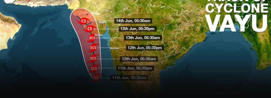
- Cyclone Vayu (It is still to develop into a cyclone and is only a deep depression as of now) is currently positioned around 250 km northwest of Aminidivi island in Lakshadweep and about 750 km southwest of Mumbai.
Background: / Cyclone Vayu
- Cyclone Vayu is slated to reach the Gujarat coast by either around midnight of June 12 or early morning of June 13.
- It is likely to dissipate very fast after that because the land and atmosphere in the area was devoid of any moisture that can sustain it any further.
- The northward progression of monsoon can be expected two to three days after that
- Vayu is much weaker than Fani. At its strongest, it is likely to generate winds of speed 110- 120 km per hour, according to current forecasts. In contrast, winds associated with Fani had speeds of about 220 km per hour.
- Vayu, even at its most powerful, therefore would only be categorised as a “severe cyclonic storm”, while Fani was an “extremely severe cyclonic storm” and almost satisfied the conditions for classification as a “super cyclone”.
- The lowest official classification used in the North Indian Ocean is a Depression, which has 3-minute sustained wind speeds of between 31–49 km/h
Deep Depression, which has winds between 50–61 km/h Cyclonic storm, wind speeds of between 62–88 km/h - Severe Cyclonic Storms have storm force wind speeds of between 89–117 km/h Very Severe Cyclonic Storms have hurricane-force winds of 118–166 km/h Extremely Severe Cyclonic Storms have hurricane-force winds of 166–221 km/h
- The highest classification used in the North Indian Ocean is a Super Cyclonic Storm, which have hurricane-force winds of above 222 km/h
Impact of Cyclone Vayu on Monsoon:
- While Vayu is unlikely to result in widespread destruction, the cyclone is expected to interfere with normal progression, by sucking all the moisture from the monsoon winds towards itself.
- Cyclones are sustained by very strong low-pressure areas at their core. Winds in surrounding areas are forced to rush towards these low-pressure areas.
- Similar low-pressure areas, when they develop near or over land, are instrumental in pulling the monsoon winds over the country as well.
- But right now, the low-pressure area at the centre of the cyclone is far more powerful than any local system that can pull the monsoon winds moving northeast.
Arabian Sea Cyclones:
- Though cyclones are common in the June, very few of them originate in the Arabian Sea as compared to Bay of Bengal.
- In the last 120 years for which records are available, just about 14% of all cyclonic storms, and 23% of severe cyclones, around India have occurred in the Arabian Sea.
- Arabian Sea cyclones are relatively weak compared to those emerging in the Bay of Bengal. Also, most of the cyclones emerging in the Arabian Sea are headed towards Gujarat Coastline. As Gujarat Coastline is not very densely populated, the damage potential of the cyclones on the western coast is comparatively low.


