

FIRE-BREATHING CLOUDS
04, Jan 2020
Prelims level : Climate Change and its Impacts
Mains level : Disaster and Disaster Management
Context:
- Australia’s bushfires are growing so massive and powerful that they create their own weather phenomenon.
- According to Bureau of Meteorology office, Victoria, it has observed the
- pyro-cumulonimbus cloudsabove eastern part of state.
- These fire-induced storms bring little rain, but are packed with lighting that can spark new fires.
Fire making Thunderstorms:
- The bushfires in the country have reached a point where they are generating their own weather, creating a feedback loop that will make the already dire situation worse.
- Experts have still not understood the mechanism behind this weather phenomenon, but unlike regular thunderstorms, these are ‘dry’.
- This means they don’t produce rain, only lighting, which may spark more wildfires.
- This new weather system produces strong winds that Stoke Existing Wildfires.
Fire storm:
- The term “firestorm” is a contraction of “fire thunderstorm”. In simple terms, they are thunderstorms generated by the heat from a bushfire. Firestorms also produce dry lightning, potentially sparking new fires, which may then merge or coalesce into a larger flaming zone.
- The crucial difference here is that this upward movement is caused by the heat from the fire, rather than simply heat radiating from the ground.
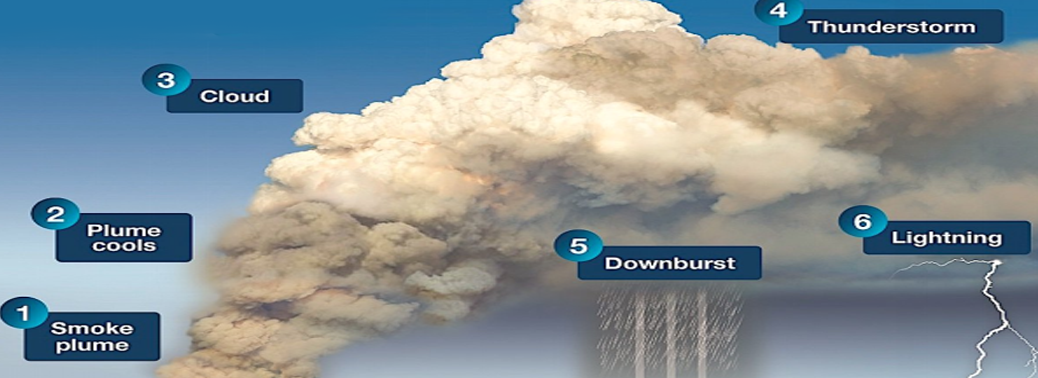
Cycle of this weather phenomenon:
1. Pyrocumulonibus Thunderstorms:
- It is developed to altitudes over 16km.These fire-induced storm can spread fires through lighting, lofting of embers and generation of severe wind outflows.
- It is much like a normal thunderstorm that forms on a hot summer’s day. Conventional thunderclouds and pyro-cumulonimbus share similar characteristics. Both form an anvil-
- shaped cloud that extends high into the troposphere (the lower 10-15km of the atmosphere) and may even reach into the stratosphere beyond.
- The weather underneath these clouds can be fierce. As the cloud forms, the circulating air creates strong winds with dangerous, erratic “downbursts” – vertical blasts of air that hit the ground and scatter in all directions.
- Similar to typical thunderstorms, both are created through rapidly rising air caused by heating of the air column.
2. Smoke Plume
- In pyro-cumulonimbus, the fire heats the air so intensely that it fuels rapidly rising motion above the fire, like the updrafts in thunderstorms that can reach speeds over.
3.Plume Cools
- This propels smoke and ash several kilometres into the atmosphere, where the air cools and the available water vapour condenses into visible clouds.
4.Clouds
- The ash then helps condense the water vapour into droplets by acting as condensation nuclei- dust for the moisture to cling onto.
5. Downpour
- But the difference is that unlike real thunderstorms, the rain that falls is evaporated by the heat and dryness of the fire before it can reach the ground.
6. Thunderstor & Lighting
- The faster the process takes place the more likely the clouds are to spark lighting, just like real thunderstorms.


