Oceanography
changes12.1 OCEANS – AN INTRODUCTION
- About three – fourth of the earth is covered by Hydrosphere.
- The hydrosphere covers nearly 71% of the total surface area of the earth.
- The Hydrosphere is divided into Oceans, Inland Seas, Small enclosed seas, Bays, etc. on the basis of their size and location.
- The four major oceans of the earth are Pacific Ocean, Atlantic Ocean, Indian Ocean and Arctic Ocean.
- The ‘land’ under the waters of the oceans, is known as the ocean floor exhibits complex and varied features as like observed over the land
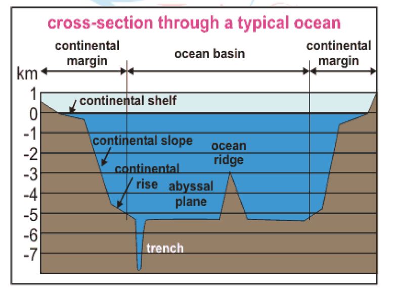
- The ocean floors are characterized by four relief zones – Continental Shelf, Continental Slope, Deep Sea Plain and Oceanic deep or trench.
- Besides, these divisions, there are also major and minor relief features in the ocean floors like ridges, hills, seamounts, guyots, trenches, canyons, etc.
- The average depth of ocean is 3,800 m against the 840 m average height of lithosphere
Subterranean Water Body: The World’s largest underground ocean, i.e. Subterranean Water Body was discovered in the year 2007. This massive underground ocean extends from Indonesia to the northern tip of Russia for a length of 700 km – 1400 km below the ground surface.
1. CONTINENAL SHELF
- The Continental marginal areas submerged under oceanic water with average water depth of 100 fathoms (1 fathom – 6 feet) and gently sloping (1°-3°) towards the sea are called Continental Shelves.
- Continental Shelf is the extended margin of each continent occupied by relatively shallow seas and gulfs.
- It is the shallowest part of the ocean showing an average gradient of 1° or even less.
- The shelf typically ends at a very steep slope, called the shelf break.
- The continental shelves are covered with variable thicknesses of sediments brought down by rivers, glaciers, wind, from the land and distributed by waves and currents.
- Massive sedimentary deposits received over a long time by the continental shelves, become the source of fossil fuels.
12.2.1 CONTINENTAL SHELF
DISTRIBUTION
The width of the continental shelves varies from one ocean to another. The average width of continental shelves is about 80 km. The depth of the shelves also varies. It may be as shallow as 30 m in some areas while in some areas it is as deep as 600 m.
The width of continental shelves largely depends on the nature of reliefs of the coastal land. They are
- . The shelves are narrow, where high mountains are very close and parallel to the coast. (E.g. Pacific continental shelf along the west coast of South America, as Mount Andes run parallel to it- The shelves are almost absent or very narrow along some of the margins like the coasts of Chile).
- The shelves are wider where the coast lands are wide plains. (E.g. The Siberian shelf in the Arctic Ocean, the largest in the world, stretches to 1,500 km in width).
12.2.2 CONTINENTAL SHELF IN INDIA
- The maximum seaward limit of the continental shelves off the Indian coast is demarcated by 100 fathom contour.
- The continental shelves along the Eastern and Western coasts of India are 50 km and 150 km wide respectively.
- The shelves are narrow (30-35 km) off the mouths of the Ganga, the Mahanadi, the Godavari, the Krishna and the Cauvery rivers. These shelves are wider off the estuaries of the Narmada, the Tapi and the Mahi rivers.
- The average slope of the continental shelves off the Eastern Indian coast is about 21°, it is 10° near Cape Comorin and only 1° near the Gulf of Cambay.
12.2.3 ECONOMIC SIGNIFICANCE –CONTINENTAL SHELF
- Most commercial exploitation from the sea, such as metallic-ore, non-metallic ore, and hydrocarbon extraction, takes place on the continental shelf.
- The shallowness enables sunlight to penetrate through the water, which encourages the growth of minute plants and other microscopic organisms – planktons (food for fishes). Thus continental shelves are the richest fishing grounds in the world. E.g. Grand Banks of Newfoundland, the North Sea and the Sunda shelf.
- Their limited depth and gentle slope increase the height of tides. Since ships can only enter and leave port on the tide, most of the World’s greatest seaports including Southampton, London, Hong Kong, Singapore and Rotterdam are located on Continental Shelves.
INTERNATIONAL CONVENTION ON CONTINENTAL SHELF
- Sovereign rights over their continental shelves up to a depth of 200 metres or to a distance where the depth of waters admitted of resource exploitation were claimed by the marine nations that signed the Convention on the Continental Shelf drawn up by the UN’s International Law Commission in 1958.
- This was partly superseded by the 1982, United Nations Convention on the Law of the Sea which created the 200 nautical mile-exclusive economic zone and extended continental shelf rights for states with physical continental shelves that extend beyond that distance.
- The legal definition of a continental shelf differs significantly from the geological definition. UNCLOS states that the shelf extends to the limit of the continental margin, upto 200 nautical miles from the baseline.
- Thus inhabited volcanic islands such as the Canaries, which have no actual continental shelf, have a legal continental shelf, whereas uninhabitable islands have no shelf.
12.3. CONTINENTAL SLOPE
- The zone of steep slope extending from the Continental shelf to the deep sea plains is called Continental Slope which varies from 5°to more than 60° at different places.
- At the edge of the Continental Shelf, there is an abrupt change of gradient, forming the Continental Slope.
- The Continental Slope connects the continental shelf and the ocean basins.
- The most significant reliefs on the continental slopes are found
between 20°N and 50°N latitudes and on 80°N and 70°S latitudes. - Generally, the steep gradient of the continental slopes does not allow any marine deposits.
- It begins where the bottom of the continental shelf sharply drops off into a steep slope.
- The gradient of the slope region varies between 2-5°.
- The depth of the slope region varies between 200 and 3,000 m.
- The slope boundary indicates the end of the continents.
- Submarine Canyons and trenches are significant reliefs in this region, generally transverse to the continental shelves and the coasts.
12.4 DEEP SEA PLAIN
- Deep Sea Plain is the flat and rolling submarine plain lying two or three miles below sea level, and covering two-thirds of the ocean floor, generally termed as Abyssal Plains.
- These are gently sloping areas of the ocean basins cover 75% of the total area of the ocean to the other.
- These are the flattest and smoothest regions of the world. (Modern sounding services reveal that abyssal plain is not being level and it has extensive submarine plateaux ridges, trenches, guyots basins and oceanic islands)
- The depths vary between 3,000 and 6,000 m.
- These plains are covered with fine-grained sediments like clay and silt.
- The submarine ridges with steep side-slopes reach the sea level and even project above the water surface and appear as islands. E.g. Mid-Atlantic ridge.
12.5 OCEANIC DEEPS OR TRENCHES
- Ocean deeps represent depressions and trenches (reaches depth of 5,000 fathoms) on the ocean floors, are the deepest parts of the ocean basins.
- Ocean deeps are grouped into
- Deeps: very deep but less extensive depressions.
- Trenches: long and narrow linear depressions. (E.g. Mariana Trench located to the west of Philippines in the North Pacific Ocean is the
deepest trench (11,000 metres)). - These are generally located parallel to the coasts facing mountains and along the islands. They are more often found close to the continents, particularly in the Pacific Ocean.
- The trenches are relatively steep sided, narrow basins. They are some 3-5 km deeper than the surrounding ocean floor.
- They occur at the bases of continental slopes and along island arcs and are associated with active volcanoes and strong earthquakes. That is why they are very significant in the study of plate movements.
- As many as 57 deeps have been explored so far; of which 32 are in the Pacific Ocean; 19 in the Atlantic Ocean and 6 in the Indian Ocean.
12. 6 MINOR RELIEF FEATURES
Apart from the above mentioned major relief features of the ocean floor, some minor but significant features predominate in different parts of the oceans.
I. MID-OCEANIC RIDGES
- A mid-oceanic ridge is composed of two chains of mountains separated by a large depression.
- The mountain ranges can have peaks as high as 2,500 m and some even reach above the ocean’s surface.
- Iceland, a part of the mid- Atlantic Ridge, is an example.
II. SEAMOUNT
- It is a mountain with pointed summits, rising from the seafloor that does not reach the surface of the ocean.
- Seamounts are volcanic in origin.
- These can be 3,000-4,500 m tall.
- The Emperor seamount, an extension of the Hawaiian Islands in the Pacific Ocean, is a good example.
III. SUBMARINE CANYONS
- These are long, narrow and very deep valleys located on the continental shelves and slopes with vertical walls resembling the continental canyons are called submarine canyons.
- They are sometimes found cutting across the continental shelves and slopes, often extending from the mouths of large rivers.
- Submarine canyons are classified on the morphogenesis as
- Glacially eroded canyons
- Non-glacial canyons
- The Hudson Canyon is the best known canyon in the world.
IV. GUYOTS
- It is a flat topped seamount.
- They show evidences of gradual subsidence through stages to become flat topped submerged mountains.
- It is estimated that more than 10,000 seamounts and guyots exist in the Pacific Ocean alone.
V. ATOLL
- These are low islands found in the tropical oceans consisting of coral reefs surrounding a central depression.
- It may be a part of the sea (lagoon), or sometimes form enclosing a body of fresh, brackish, or highly saline water.
13. RELIEFS OF THE OCEANS
13.1 BOTTOM RELIEFS OF ATLANTIC OCEAN
13.1.1 ATLANTIC OCEAN – ATLANTIC OCEAN
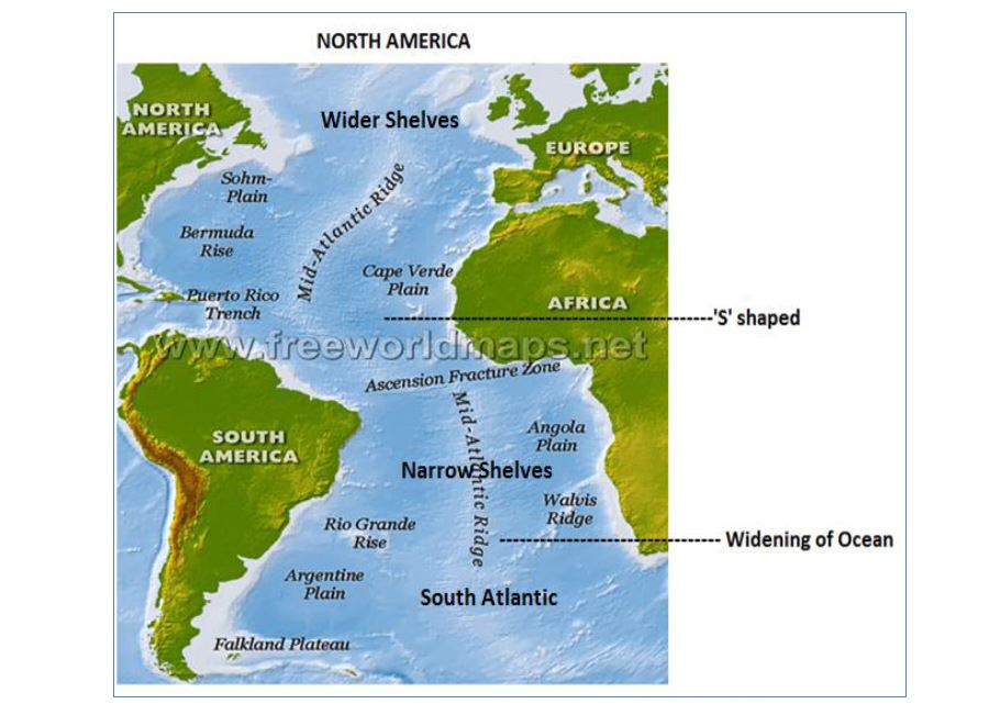
- The Atlantic Ocean located between North and South Americas in the West and Europe and Africa in the East covers an area of 82,000,000 km.
- It covers one-sixth of the geographical area of the earth.
- The ‘S’ shape of the ocean indicates the fact that landmasses (continents) on its either side were once a contiguous part.
- The ocean was formed due to drifting of North and South America to the west due to plate tectonics.
- The average depth of the ocean is less than the Pacific Ocean because of continental shelves and marginal and enclosed seas.
- The Atlantic Ocean widens to the south of equator. It narrows down towards the equator. It narrows down in the extreme north and contacts the Arctic Ocean.
- Currently, widening of the ocean (4 cm/year) is observed through seafloor spreading.
13.1.2 CONTINENTAL SHELF
- Continental Shelves have developed along both the coasts of Atlantic Ocean and with the width ranging from 2-4 km to 80 km.
- The width of continental shelves has been largely controlled by the reliefs of the coastal lands.
- Narrow shelves are observed when mountains and hills border the coasts.
E.g. the African shelves and Brazilian shelves between 5° and 10° S latitudes. - Wider shelves (200-400 km) are observed along the north-eastern coast of North America and the north-western coast of Europe.
E.g. Extensive shelves are found around Newfoundland and British Islands. Very extensive shelves are found in South Atlantic Ocean, mainly between Antarctica and Argentina. - Many marginal seas are located on the continental shelves in the North Atlantic, but absent in the South Atlantic.
- Continental shelf-seated seas significant are Hudson Bay, Baltic Sea, North Sea, Davis Strait, Denmark Strait, etc.
- Several islands are located on the shelves – Iceland, Newfoundland, Falkland, British Isles, West Indies, Canaries, St. Helena, etc.
ATLANTIC OCEAN
13.1.3 MID-ATLANTIC RIDGE
- The mid-Atlantic ridge representing the zone of divergent or constructive plate margins (American plates moving westward and Eurasian and African plates moving to the east) is the most striking relief feature which having ‘S’ shape extending from Iceland(north) to Bouvet Island(south).
- This ridge is known as Dolphin rise (north of the equator) and
Challenger rise (south of the equator). - Though major part of the mid Atlantic ridge is submerged under oceanic water but number of peaks and sea mounts project well above the water surface and forms islands. E.g. Pico island of Azores (8,200 m).
- The mid-Atlantic ridge has number of fracture zones. E.g. Gibbs fracture zone, Atlantis fracture zone, Oceanographic fracture zone, etc.
Important features of Mid Atlantic Ridge Wyville Thompson ridge – between Scotland & Ireland, Telegraphic plateau – between Greenland & Iceland (first cables laid down), Newfoundland rise, Azores rise, Sierra Leone rise, Para rise, Guinea ridge, Walvis ridge and Rio Grande rise are some of the important relief features in Mid Atlantic ridge.
13.1.4 OCEAN BASINS
- The mid-Atlantic Ridge divides the Atlantic Ocean into two major basins- East and West Atlantic Basins.
- Labrador Basin extends between the continental shelf of Greenland in the north and Newfoundland rise in the south covering latitudinal extent of 40°N to 50°N where the depth of basin ranges from 4,000 to 4,500 m.
- North American Basin is the most extensive basin of the Atlantic Ocean and extends between 12°N and 40°N latitudes.
- Brazilian Basin is confined between the Equator and 30°S latitude an East coast of Brazil in the west and Para Rise in the east. The depth is more than 4,000 m.
- Spanish Basin is located between the mid-Atlantic Ridge and Iberian Peninsula. It is bordered by Azores Rise in the south and extends upto 50°N latitude. The average depth is 5,000 m.
13.1.5 OCEAN DEEPS
- The number of deeps in the Atlantic Ocean is far less than in the Pacific Ocean because of the absence of effects of Tertiary orogenic movements along the Atlantic coasts.
- The Mediterranean Sea, Caribbean Sea and Gulf of Mexico are significant marginal seas in the Atlantic Ocean.
- The Mediterranean Sea is divided into two major basins (East & West Basins) by 4,000 m deep mid-sea ridge (which runs from Southern Italian coast and to the North American coast).
- The Gulf of Mexico and Caribbean Sea are separated by 1,600 m deep ridge running between Yucatan peninsula and Cuba Island.
- The prominent basins are Mexico basin and Caribbean basin.
13.2 BOTTOM RELIEFS OF THE PACIFIC OCEAN
13.2.1 PACIFIC OCEAN – INTRODUCTION
- The Pacific Ocean is the largest ocean in the Earth covering one-third area.
- It extends for 16,000 kms from the East coast of Asia (west) to the West coast of Americas (east). Its north-south extension is 15,000 kms from Bering Strait (north) to the north of Cape Adre, Antarctica (south).\
- The overall shape of the ocean is triangular and the average depth is 4,500 m.
- Both the coasts of the Pacific Ocean are paralleled by the chains of folded mountains, resulting in the steep abyssal plains.
- The ocean has the largest number of islands (>2000). It has numerous islands, island arcs and festoons in the western coast and only few islands in the eastern coast.
Classification of Pacific Islands:
- Continental Islands: Aleution island, Chilean island
- . Island Arcs and Festoons: Kurile, Japanese Archipelago, Philippines, Indonesian islands
- Scattered smaller Islands:
- i. Islands based on racial groups: Malanesia, Micronesia & Polynesia
- ii. Islands formed of volcanic materials & Coral reefs – Hawaii island, Fizi, Ellice, Coral Islands
13.3.2 Classification of Pacific Ocean
- . North Pacific: Deepest part (5000-6000 m), in contact with Arctic sea through Bering Strait.
- Central Pacific: Largest number of islands (volcanic & coral).
- South-West: number of Islands, Marginal seas, Continental shelves, Oceanic trenches.
- South-East: East Pacific Rise or Ridge (absence of marginal seas).
13.3.3 CONTINENTAL SHELF
- The Shelves are broad and extensive along the Eastern coasts of Australia and Asia where the width varies from 160 – 1600 km and the depth ranges between 1000 – 2000 m.
- Several Islands are seated on broad continental shelves. E.g. Kuril Islands, Japanese Islands, Philippines, Indonesia, New Zealand, etc.
- The continental shelves carry numeral marginal seas like Bering Sea, Okhotsk Sea, Japan Sea, Yellow Sea, China Sea, Java Sea, Coral Sea, Tasmanian Sea, Arafura Sea, etc.
- The continental shelves are less extensive along the western coast of Americas, because of presence of cordillerean chains of folded mountains to the coastal lands.
13.3.4 EAST PACIFIC RISE
- The Pacific Ocean does not have mid-oceanic ridge like Atlantic or Indian Ocean (only few scattered ridge of local importance).
- The East Pacific Rise or Ridge known as Albatross Plateau is 1600 km wide and it extends from north of New Zealand to the Californian coast.
- Other significant features in East Pacific Rise: New Zealand ridge, Fiji plateau, Hawaiian rise (most extensive ridge of the Pacific Ocean), New Guinea rise, etc.
- Fracture zones: Mendocino fracture zone, Murray fracture zone, Eastern Island fracture zone, Challenger fracture zone, etc.
13.3.5 OCEAN BASINS
- There are different basins of different shapes and sizes. These basins are separated by ridges and ‘rises’.
- Philippines Basin is located to the east of Philippines and extends from south of Japan to 5°N latitude. Kyushu – Paian Ridge runs through the middle of
the basin. Average depth ranges from 5000 m – 6000 m. - Fiji Basin is located to the south of Fiji Island between 10° S and 32° S latitudes and the average depth is 4000 m. The basin to the north of 20° S is known as North Fiji Basin whereas the South Fiji basin between 20° and 32°S.
- East Australian Basin is situated between the east coast of Australia and New Zealand Ridge with average depth of more than 5000 m.
- South Australian Basin also known as Jeffreys Basin is located to the south-east of Australia having average depth of 5000 m.
- Peru Basin is located to the west of Peru coast between 5° S and 24° S latitudes extends upto 110° W longitude. The average depth of the basin is 4000 m.
13.3.6 OCEAN DEEPS
- There are several trenches and deeps in the Pacific Ocean. These depressions are located either along the island arcs or mountain chains.
- These trenches are found mainly in the western Pacific Ocean.
BOTTOM RELIEFS OF THE INDIAN OCEAN
INDIAN OCEAN – INTRODUCTION
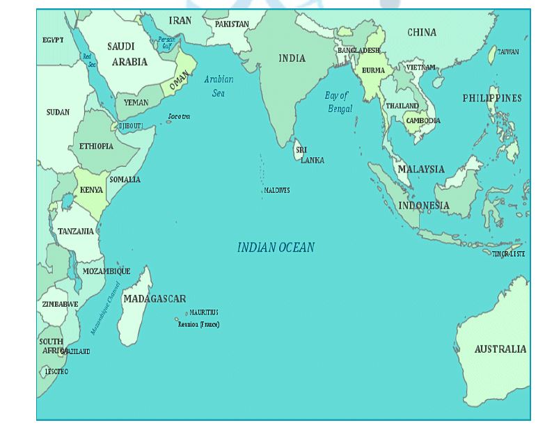
- The Indian Ocean is the third largest ocean by area and it is bounded by Asia in the north and east, Africa in the west, Australia in the south-east and Antarctica in the south.
- The ocean has contact with the Pacific and Atlantic Ocean in the south near Antarctica and the average depth of the ocean is 4,000 m.
- Major parts of the coastal lands are formed by Block Mountains of Gondwana land.
- The marginal seas are less compared to the Pacific and the Atlantic Oceans. Some of the marginal seas are Mozambique Channel, Andaman Sea, Arabian Sea, Bay of Bengal, Persian Gulf, Red Sea, etc.
- Madagascar and Sri Lanka are big islands, whereas Laccadive, Andaman-Nicobar, Seychelles, St. Paul, Maldives, etc. are small islands.
- Indian subcontinent in the north divides the Indian Ocean into – Arabian Sea & Bay of Bengal in the north and the Indian Ocean widens in the south.
Classification of Indian Ocean:
- Western Zone: Between African coast and mid-Indian oceanic ridges has the largest number of islands.
- Eastern Zone: Deepest zone (5500 m), Narrow continental shelves with steep slopes.
- Central Zone: represents mid-oceanic ridges with numerous islands.
CONTINENTAL SHELF
- Continental shelves are extensive along the margins of Bay of Bengal, Arabian Sea, Eastern coast of Africa and Madagascar (lies on continental shelf itself).
- Continental shelves are narrow along the coasts of Java and Sumatra.
- On an average, the continental shelves are very wide (640 km) in the west and narrow (160 km) in the east and it becomes further narrow in the north of Antarctica.
CENTRAL RIDGE or MID- OCEANIC RIDGE
- The Central ridge or mid-oceanic ridge known as Mid-Indian Oceanic Ridge extends from southern tip of Indian peninsula to Antarctica in the south almost in North-South direction and forms a continuous chain of highlands.
- Islands are formed from the emergence of central ridge or its branches above the sea level.
Important Ridges of the Indian Ocean:
- Maldive ridge (Laccadives-Chagos ridge) • Chagos – St. Paul ridge (between Equator & 30° S)
- Amsterdam-St. Paul plateau (between 30° S -50° S )
- Kerguelen-Gaussberg ridge • Indian-Antarctic ridge
Branches of the Central Ridge:
- Carlesbreg ridge (5° S latitude – extends to North East Africa)
- Seychelles-Mauritius ridge (18° S latitude near Mauritius island)
- Madagascar ridge (from south tip of Madagascar to 40° S latitude)
- South West Indian ridge (near 23° S latitude)
- Ninety East ridge (north-south direction parallel to 90° E longitude upto 40° S)
OCEAN BASINS
- The Mid-Indian Oceanic Ridge divides the Indian Ocean into two major basins – the Eastern and the Western basins.
- These basins are further divided into sub-basins by Central Ridge.
Oman Basin: It faces the Gulf of Oman and is spread over the extensive continental shelf with average depth of 3,600 m.
- Arabian Basin: It is located in almost circular shape between Laccadives-Chagos ridge and Socotra- Chagos ridge with the depth of 3,600 – 5,500 m.
- Somalia Basin: It is bordered by Socotra- Chagos in the northwest, Central ridge in the east, Seychelles-Mauritius ridge in the southwest and African coast in the west. The average depth is 3,600 m.
- Mauritius Basin: It is located between South West Indian ridge and south Madagascar ridge and extends from 20° S to 40° S latitude. The deepest part measures 6,400 m.
- Other Basins: Mascarene basin (between Madagascar and Seychelles-Mauritius ridge), Agulhas-Natal basin, Atlantic-Indian-Antarctic basin, Eastern Indian-Antarctic basin, West Australian basin and Mid-Indian basin.
DEEPS & TRENCHES
- There are very few deeps and trenches in the Indian Ocean.
- Above 60% of the Indian Ocean consists of deep sea plains with depth ranging from 3,600 m – 5,500 m.
- Important Deep Sea Plains: Somali abyssal plain, Ceylone abyssal plain, Indian abyssal plain, etc.
- Significant Trenches: Sunda trench, Ob trench, Mauritius trench, Amirante trench, etc.
14. TEMPERATURE DISTRIBUTION IN OCEAN
14.1 INTRODUCTION
- The temperature of ocean water varies from place to place both at the surface and at great depths.
- Water warms up and cools down much more slowly than the land; hence the annual range of temperature in any part of the ocean is very much smaller.
- Generally, the mean annual temperature of the surface ocean water decreases from 21° C in equatorial areas to around 12.7° C in 45° N and S latitudes and drops almost to freezing point at the poles.
- The reduction of temperature with latitudes is also not constant, because of interference by warm and cold currents, winds and air masses.
- The temperature of the oceanic water is important for marine organisms including plants (phytoplanktons) and animals (zooplanktons).
- The temperature of sea water also affects the climate of coastal lands and plants and animals therein.
- The study of both, surface and subsurface temperature of sea water is significant.
- Standard type of thermometer is used to measure the surface temperature, while reversing thermometers and thermographs are used to measure the subsurface temperature.
14.2 CLASSIFICATION OF LAYERS BASED ON TEMPERATURE
- FIRST LAYER represents the top layer of warm oceanic water and is 500 m thick with temperature ranging between 20° and 25° C. This layer is present in Tropics throughout the year, but it is present in mid-latitudes only during summer.
- THERMOCLINE LAYER represents vertical zone of oceanic water below the first layer and is characterised by rapid rate of decrease of temperature with increasing depth.
- THIRD LAYER is very cold and extends upto the deep ocean floor. The Polar areas have only one layer of cold water from the surface to the deep ocean floor.
14.3 SOURCE OF TEMPERATURE IN OCEANS
- The major source of the temperature of oceanic water is the Sun. The radiant energy transmitted from the photosphere of the sun in the electromagnetic shortwaves and received at the ocean floor is called Insolation.
- The amount of insolation to be received at the sea surface depends on the angle of sun’s rays, length of the day and the distance of the earth from the sun and effects of the atmosphere.
- Some negligible amount of energy is received from the bottom through the compression of sea water.
14.4 DAILY RANGE OF TEMPERATURE
- The difference of maximum and minimum temperature of a day (24 hour) is known as daily range of temperature.
- The daily range of temperature of surface water of the oceans is almost around 1° C only. The daily range of temperature is usually 0.3° C in the lower altitudes and 0.2° to 0.3° C.
- The diurnal range depends on the conditions of sky, Stability or instability of air and stratification of sea water.
On an average, the maximum and minimum temperatures of sea surface waters are recorded at 2 PM and 5 AM respectively.
14.5 ANNUAL RANGE OF TEMPERATURE
- The maximum and minimum annual temperatures of ocean water are recorded in August and February respectively.
- Usually, the average annual range of temperature of ocean water is -12° C but there is a lot of regional variation which is due to regional variation in insolation, nature of seas, prevailing winds, location of seas, etc.
- Annual range of temperature is higher in the enclosed seas than in the open seas.
- The size of the oceans and seas also affects annual range of temperature (bigger the size, lower the annual range and vice versa).
- The Atlantic Ocean records relatively higher annual range of temperature than the Pacific Ocean.
14.6 DISTRIBUTION OF TEMPERATURE
- The following factors affect the distribution of temperature of ocean water.
i. Latitudes: - The temperature of surface water decreases from equator towards the poles, as the insolation of sun decreases poleward.
ii. Unequal distribution of Land and Water:
- The temperature of ocean water varies in the northern and southern hemispheres because of dominance of land in northern hemisphere and water in southern hemisphere.
- The surface water of oceans in the northern hemisphere receives more heat due to their contact with larger extent of land than oceans in the southern hemisphere.
- The isotherms are not regular in the northern hemisphere because of land masses and they are regular in the southern hemisphere, because of dominance of water.
- The temperature in the enclosed seas in low altitudes becomes higher because of the surrounding land areas.
- E.g. Annual temperature of surface water at the Equator is 26.7° C, whereas in Red Sea, it is 37.8° C.
iii. Prevailing Winds:
- Wind direction largely affects the distribution of temperature of ocean water.
- The winds blowing from the land towards the oceans and seas (offshore) reduces the temperature, whereas the onshore winds raise the temperature in ocean.
- E.g. Trade winds cause low temperature (offshore – Eastern margins of oceans/ Western coastal regions of the continents in tropics), Trade winds raise the temperature (onshore – Western margins of oceans/ Eastern coastal areas of the continents).
iv. Ocean Currents:
- Surface temperatures of the oceans are controlled by warm and cold currents.
- Warm currents raise the temperature of the affected areas, whereas Cold currents lower down the temperature.
- E.g. Gulf Stream warm current raise the temperature near the eastern coasts of North America, Labrador cold current lowers down the temperature of north-east coast of North America.
- Warm currents raise the temperature more in the northern hemisphere than in the southern hemisphere.
v. Minor Factors:
- Submarine ridges, Local weather conditions like cyclones, hurricanes, fog, etc. , Location and shape of the sea, Longitudinal and Latitudinal extensions of the seas, Open and enclosed seas are the other minor factors determine the distribution of temperature in ocean.
14.7 HORIZONTAL DISTRIBUTION OF TEMPERATURE
- On an average, the temperature of surface water of the ocean is 26.7° C (80° F) and the temperature gradually decreases from Equator towards the poles.
- The rate of decrease of temperature with increasing latitudes is generally 0.5° F per latitude.
- The average temperature at 20° latitudes is 22° C, it is 14° C at 40° latitudes and 0° C near the poles.
- The oceans in the northern hemisphere record relatively higher average temperature than in the southern hemisphere.
- The average annual temperature of all the oceans is 17.2° C (Northern Hemisphere – 19.4°C/ Southern Hemisphere – 16.1° C). This variation in temperatures in Northern and Southern hemisphere is because of unequal distribution of land and ocean water.
- The average seasonal temperatures of surface waters of the oceans are represented through Isotherms.
- The temperature of the surface water of the oceans is higher than the air temperature above the ocean surface (ocean surface gives off heat to the surface – influences sea waves and ocean currents).
Observations:
- Lowest temperatures of the oceans – New Scotland region
- Highest temperatures of the oceans – Western Pacific Ocean region
- Average annual temperature of Pacific Ocean is higher than Atlantic Ocean and Indian Ocean.
- In Atlantic Ocean, Decrease of temperature with increase in latitudes is very low because of warm ocean currents.
14.8 VERTICAL DISTRIBUTION OF TEMPERATURE
- The maximum temperature of the oceans is always at their surface, because it directly receives the insolation and the heat is transmitted to the lower sections of the oceans through conduction mechanism.
- The solar rays very effectively penetrate upto 20 m depth and do not go beyond 200 m depth.
- The rate of fall of temperature is very rapid upto the depth of 200 m (1°F for every 10 fathoms) and thereafter the rate of decrease of temperature is slowed down. The temperature decreases from the ocean surface with increasing depth and it is not uniform.
In the ocean deeps below 200 fathoms, water is uniformly cold (little above freezing point), and even in the deepest trenches also the water never freezes. It is estimated that over 80% of all ocean waters have a temperature between 1.6° C and 4.4° C.
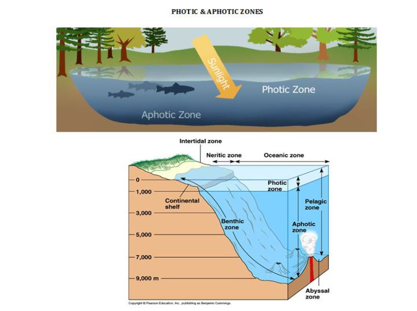
- The oceans are vertically divided into two zones. They are
- i. Photic or Euphotic zone: It represents the upper surface upto the depth of 200 m and receives solar radiation.
- Aphotic zone: It extends from 200 m depth to the bottom and does not receive solar rays.
14.8.1 FEATURES OF VERTICAL DISTRIBUTION OF TEMPERATURE OF OCEAN WATER
- The sea temperature decreases with increasing depth, but the rate of decrease of temperature is not uniform (change in temperature below the depth of 2000 m is negligible).
- Diurnal and Annual ranges of temperature cease after the depth of 5 fathoms (30 feet) and 100 fathoms (600 feet) respectively.
- The rate of decrease of temperature with increasing depth is more rapid near the equator than towards the poles.
- In some areas, high temperature is recorded at greater depths. E.g. Mediterranean Sea records 24.4° c at the depth of 1,800 m. The enclosed seas of high latitudes register inversion of temperature, i.e. the temperature of sea surface is lower than the temperature below the surface waters.
There are 3 vertical layers in oceans: - UPPER LAYER represents the top layer of warm water mass with a thickness of 500 m with the average temperature ranging between 20° and 25° C. This layer is present in Tropics throughout the year, but it is present in mid-latitudes only during summer. In upper layer, the lighter ocean water mass floats over the thickest heavy water mass of the oceans extending upto the ocean bottoms.
- LOWER LAYER is very cold and extends beyond 1,000 m depth upto the ocean floor. This layer represents denser ocean water mass.
- THERMOCLINE LAYER represents vertical transition zone of oceanic water and it is between the upper and the lower layer of the ocean. It is characterised by rapid rate of decrease of temperature with increasing depth.
There also exist seasonal thermoclines between the depth of 40 m and 100 m. These are formed due to heating of water surface through solar radiation during summer season. Diurnal Thermoclines form in shallow water depth usually less than 10-15 m. The polar seas have only one layer of cold water mass from the ocean surface to the deep ocean floor.
14.9 DENSITY OF OCEAN
- Density refers to the amount of mass per unit volume of substance and it is generally measured in g/cm3.
- The density of Pure (Distilled) water is 1 g/cm3 at the temperature of 4° C(The density of pure water is taken as standard for the measurement of density of other substances like salt in it).
- Since the salt water has some dissolved substances in it, its density is slightly higher than pure water.
- The average salinity of sea water is 1.0278 g/cm3 which is 2-3% higher than density of pure water (1.00 g/cm3) at 4° C temperature.
- The density of sea water gradually increases with decreasing temperature and highest density is recorded at the temperature of -1.3° C.
- The density determines the dynamics of ocean water. Relatively lighter sea water floats and moves horizontally, whereas heavier sea water sinks.
14.9.1 CONTROLLING FACTORS OF DENSITY OF SEA WATER
- The density of sea water is related to following 3 factors
i. Temperature
ii. Pressure
iii. Salinity
TEMPERATURE:
- Temperature and density of sea water are inversely related.
- It is noted that the role of temperature in controlling water density is more pronounced in low latitudes, whereas the importance of temperature in controlling sea water decreases poleward. The temperature of seawater below freezing point cannot increase sea water density because at 0° C temperature water starts freezing with the formation of ice crystals, which do not allow water molecules to come closer and coalesce.
- Since, there is less variation in temperature of sea water in polar areas, and hence the role of temperature as controlling factor of sea water density is minimised.
PRESSURE
- Pressure is directly positively related to ocean water through its compressive effects, seawater density increases with increasing pressure and vice versa.
- The pressure is considered as minor factor of seawater density.
- The density of sea water at the bottom of tranches is 5% higher than that of surface area.
SALINITY
- Salinity is directly positively related to seawater density.
- On an average, seawater density increases with increasing salinity and vice versa. E.g. Density of pure water is 1.00 g/cm3 and density of water with 35% salinity is 1.028 g/cm3.
- This is due to the fact that dissolved salt in sea water becomes denser than pure water.
14.9.2 DENSITY STRATIFICATION OF OCEANS
There are 3 layers in seawater from sea surface to the ocean bottoms. They are
- Surface Layer of Lowest density
- Pynocline Layer of sharp density gradient
- Deep or bottom layer of highest but uniform density.
15. DISTRIBUTION OF SALINITY
15.1 SALINITY – INTRODUCTION
- Salinity is defined as ‘the total amount of solid material in grams contained in 1 kg of sea water and is expressed in parts per thousand’.
- Salinity is also defined as the ratio between weight of the dissolved materials and the weight of the sample sea water.
- i. More saline water freezes slower than lesser saline water.
- ii. The boiling point of saline water is higher than fresh water.
- iii. Salinity increases the density of sea water.
- iv. Evaporation is lower over more saline water. v. Variation in salinity causes ocean currents.
- Sea water contains a complex solution of several mineral substances in dilute form, as it is active solvent.
- The total amount of salt in sea water is gradually increasing, because it is brought from land every year.
- Significant salts in the oceans are Sodium Chloride (Nacl), Magnesium Chloride (Mgcl2), Magnesium Sulphate (MgSO4), Calcium Sulphate (CaSO4) and Potassium Sulphate (K2SO4).
- Besides salts, Silver, Gold and Radium also occur in minute proportion in sea water.
- It is mentioned that the proportion of various elements remains constant in sea water everywhere, though the salinity vary from place to place.
- The average salinity varies 33% – 37% in different oceans and seas.
- There are numerous nutrients like silicon, nitrogen and phosphorous in the sea water which are used by living marine organisms (arsenic, iron, manganese and copper also present).
- Basically, the source of oceanic salinity is Land.
- Rivers bring salts in solution form from the continental areas.
- Surprisingly, there is a lot of variation in the composition of sea salt and riverine salt as calcium sulphate constitutes 60% of river salinity while sodium chloride (77.8%) dominates the salinity of the ocean. River water contains only 2% of sodium chloride.
- It is pointed out that major portion of calcium brought by the rivers into oceans is consumed by marine organisms. The salt brought by the rivers also bit modified in the oceans.
- Volcanic ashes also provide some salt to the oceans.
- There is a wide range of variation in the spatial distribution of salinity within the oceans and the seas.
- Evaporation, precipitation, influx of river water, prevailing winds, ocean currents and sea waves are significant controlling factors.
Evaporation - There is a direct positive relationship between salinity and evaporation. That is, greater the evaporation, higher the salinity and vice versa.
- Salt concentration increases with rapid rate of evaporation.
- Evaporation due to high temperature with low humidity (dry condition) causes more concentration of salt and overall salinity becomes higher.
- Salinity is higher near the tropics than at the equator because both the areas (Tropic of Cancer & Tropic of Capricorn) record high rate of evaporation with dry air over it.
- Subtropical high pressure belts and trade wind belts record rapid rate of evaporation which increases salinity, but cloudy sky with high humidity lowers down the salinity in the equatorial belt.
- It is to be noted that salinity also controls evaporation.
- Precipitation is inversely related to salinity. That is, higher the precipitation, lower the salinity and vice versa.
- Therefore, Equatorial zone (regions of high rainfall) records comparatively lower salinity than sub-tropical high pressure belts (comparatively low rainfall).
- If the volume of water in the oceans increased due to heavy rainfall, the ratio of salt to the total volume of water is automatically reduced.
- The rivers bring salt from land to the oceans.
- When big and voluminous river pour down immense volume of water into the oceans, salinity is reduced at their mouths, which is observed in mouths of Ganga, Congo, Amazon, St. Lawrence, etc.
- The effect of influx of river water is more pronounced in the enclosed seas. E.g. Danube, Dneister, Dneiper, etc. reduces the salinity in Black sea (18%).
- On the other hand, where evaporation exceeds the influx of fresh river waters, there is increase in salinity (salinity of Mediterranean Sea – 40%).
- There is also seasonal variation in surface salinity with maximum and minimum runoff from the land.
- Salinity decreases with maximum runoff during rainy season and increases in the season of minimum runoff.
- Anticyclonic conditions with stable air and high temperature increases salinity of the surface water of the oceans. E.g. Sub-tropical high pressure belts represent such conditions.
- Winds also help in redistribution of salt in the oceans and the seas (winds drive away saline water to lesser saline areas).
- Trade winds drive away saline waters from the western coasts of the continents and pile them up near the eastern coasts causing low salinity in former and high salinity in latter. E.g. Salinity in Gulf of Mexico (East coast) – 36-37% and Salinity in Gulf of California (West coast) – 34%.
- Westerlies increase the salinity along the western coasts of the continents whereas they decrease the salinity along the eastern coasts of the continents.
- Ocean currents affect the spatial distribution of salinity by mixing seawaters.
- Equatorial warm currents drive away salts from the western coastal areas of the continents and accumulate them along the eastern coastal areas. The North Atlantic Drift increases salinity along the north-western coasts of Europe. Similarly, salinity is reduced along the north eastern coast of North America due to cold Labrador Current.
❖ Ocean currents have least influence in salinity in the enclosed seas but salinity in marginal seas which have communication with open seas through wider openings is affected by ocean currents. For e.g. the North Atlantic Drift raises the salinity of the Norwegian and the North Seas. - i. Salinity is reduced by precipitation
- ii. Salinity varies due to mixing of water of different character
- iii. Salinity increases due to evaporation
- The average salinity in the oceans and the seas is 35%, but is spatially and temporarily varies in different oceans, seas and lakes.
- Salinity also varies from enclosed seas through partially opened seas to open seas.
- The variation in salinity is both horizontal and vertical.
Thus, the spatial distribution of salinity is studied in 2 ways.
i. Horizontal distribution and
ii. Vertical distribution - On an average, salinity increases from equator towards the poles.
- The highest salinity is not recorded near the equator (high temperature and evaporation, but rainfall reduces salinity. Hence, it records only 35% salinity.
- The highest salinity is observed between 20° – 40° N is 36%, because this zone is characterised by high temperature and high evaporation, but comparatively low rainfall.
- The zone between 40°- 60° latitudes in both the hemispheres records low salinity of 31% and 33% in the northern and southern hemispheres respectively.
- Salinity further decreases in the polar zones because of influx of polar melt water.
- On an average, the northern and the southern hemisphere records average salinity of 34% and 35% respectively.
- i. Equatorial zones – relatively low salinity (excessive rainfall)
- ii. Tropical zone (20° – 30°) of maximum salinity (low rainfall and high evaporation)
- iii. Temperate zone – low salinity iv. Sub polar and polar zone – minimum The salinity varies in the open seas according to latitudes, but distribution of salinity in the inland seas not disturbed by latitudes.
- ii. Regional distribution:
Surface salinity of the oceans and the seas is described in 2 ways.
a. Distribution of salinity in individual oceans and
b. Salinity zones of all the oceans together - There is wide range of salinity difference in Pacific Ocean because of its shape and larger areal extent.
- Salinity remains 34.85% near the Equator.
- It increases to 35% between 15°-20° latitude in the northern hemisphere and it is still higher than 36% in the South Pacific Ocean for same latitudes (but it becomes low along Peruvian and Chilean coasts).
- Salinity decreases in western Pacific Ocean (Okhotsk Sea – 31%) because of influx of melt water brought by Oyashio current.
- Low salinity is noted in front of river mouths (Yellow river – 30%, Yangtzekiang – 33%)
- The average salinity of Atlantic Ocean is 35.67% and the highest salinity is recorded between 15°-20° latitudes.
- Salinity is increasing from Equator towards the Tropics of Cancer and Capricorn.
- Maximum salinity of 37% in the southern Atlantic is found in a region demarcated by 12° S -20° S latitudes and it gradually decreases southward.
- Comparatively, low salinity is found in front of River mouths (Amazon, Niger, Rhine, St. Lawrence).
- There are regional variations in salinity due to upwelling of water, ocean currents, in flux of water or high evaporation.
- The spatial distribution of salinity in the Indian Ocean is more variable and complex than the Pacific and Atlantic oceans.
- An average salinity of 35% is observed between 0°-10° N latitude, but it gradually decreases northward in the Bay of Bengal (due to influx of freshwater).
- On the other hand, Arabian sea records higher salinity (36%) due to higher rate of evaporation, less humid conditions and low influx of freshwater.
- Partially enclosed seas records higher salinity (40% – interior of Persian Gulf, Red sea records the highest salinity – 41% in some parts because of low precipitation and very high evaporation).
- No definite trend of distribution of salinity with depth, because both the trends of increase and decrease of salinity with increasing depths have been observed.
- The following are the characteristics of vertical distribution of salinity:
- Salinity increases with increasing depth in high latitudes.
- The trend of increase of salinity with increasing depths is confined to 200 fathoms from the surface in middle latitudes beyond which it decreases with increasing depths.
- Salinity is low at the surface at the Equator, due to high rainfall and transfer of water through equatorial currents (but salinity is observed below the surface). It again becomes low at the bottom.
- Maximum salinity is found in the upper layer of the oceanic water. Salinity decreases with increasing depth. Thus, the upper zone of maximum salinity and lower zone of minimum salinity is separated by transition zone known as Thermocline zone (above which high salinity and below which low salinity are found).
- It may be mentioned that the depth zone of oceans between 300 m – 1000 m is characterised by varying trends of vertical distribution of temperature, density and salinity of sea water. This zone represents the layer of Thermocline, Pynocline and Halocline.
- The ocean salinity has significant effects on physical property of seawater and other aspects of the oceans as follows:
- The freezing and boiling points are greatly affected and controlled by addition or subtraction of salts in sea water. The saline freezes slowly in comparison to fresh water. Pure
- water freezes at 0° C freezing point, if the salinity of water becomes 35%, then it would freeze at the temperature of -1.91° C. Similarly, boiling point of saline water is higher than fresh water.
- Salinity and density of sea water are positively correlated i.e. the salinity of seawater increases its density.
- Evaporation is controlled by salinity of the oceans. More saline water is less evaporated than less saline water. Similarly, more evaporation reduces the volume of seawater and hence the concentration of salts increases.
- Spatial variation in seawater salinity becomes potent factor in the origin of ocean currents.
- The ocean salinity also affects the marine organisms and plant community.
- The ocean water is dynamic. Its physical characteristics like temperature, salinity, density and the external forces like of the sun, moon and the winds influence the movement of ocean water.
- Ocean currents are the continuous flow of huge amount of water in a definite direction.
- Water moves ahead from one place to another through ocean currents.
- Ocean currents are influenced by two types of forces namely :
a. Primary forces that initiate the movement of water;
b. Secondary forces that influence the currents to flow. - The primary forces that influence the currents are:
a. Heating by solar energy;
b. Wind;
c. Gravity;
d. Coriolis force. - Heating by solar energy causes the water to expand. That is why, near the equator the ocean water is about 8 cm higher in level than in the middle latitudes. This causes a very slight gradient and water tends to flow down the slope.
- Wind blowing on the surface of the ocean pushes the water to move. Friction between the wind and the water surface affects the movement of the water body in its course.
- Gravity tends to pull the water down to pile and create gradient variation.
- The Coriolis force intervenes and causes the water to move to the right in the northern hemisphere and to the left in the southern hemisphere.
- These large accumulations of water and the flow around them are called Gyres.
- These produce large circular currents in all the ocean basins.
- Differences in water density also affect vertical mobility of ocean currents.
-
- The ocean currents classified based on their depth as surface currents and deep water currents: (i) Surface currents constitute about 10 per cent of all the water in the ocean, these waters are the upper 400 m of the ocean; (ii) Deep water currents make up the other 90 per cent of the ocean water.
- These waters move around the ocean basins due to variations in the density and gravity.
- Deep waters sink into the deep ocean basins at high latitudes, where the temperatures are cold enough to cause the density to increase.
- Ocean currents are classified on the basis of temperature into two types. They are Warm currents and Cold currents.
- They are also divided on the basis of velocity, dimension and direction into Drifts, Currents and Streams.
- The currents in the oceans are originated due to combined effects including internal and external factors.
- The factors controlling the origin and other characteristics of ocean currents are related to different characteristics of ocean waters, rotational mechanism of earth, external factors or atmospheric factors, and topographic characteristics of the coasts and ocean basins.
- Factors related to the earth’s nature and its rotation (include gravitational force and deflective force by earth’s rotation).
- Factors related to oceans (pressure gradient, temperature variations and salinity differences).
- Factors related to Ex-oceanic factors (atmospheric pressure and winds, evaporation and precipitation).
- Current modifying factors (direction and shape of coastlines, bottom reliefs of the ocean basins, seasonal variations and rotation of the earth).
- The rotation of the earth on its axis from west to east results in the origin of deflective force or Coriolis force which deflects the general direction of ocean current.
- The currents flowing from equator towards the North Pole and currents flowing from North Pole towards the equator are deflected to their right. Similarly, the currents from equator towards the South Pole and currents from South Pole to the equator are deflected towards their left.
- The rotational force of the Earth causes movement of the ocean water near the equator in opposite directions and Equatorial currents are generated (It flows from east to west).
- Some ocean waters moves in the direction of rotation of earth (from west to east) and forms Counter Equatorial currents.
- Local variations in the physical properties of the oceans like pressure gradient, temperature variations, density variations, salinity differences, etc. generate ocean currents.
- Due to high temperature in equatorial region, the water density decreases because of greater expansion of water particles whereas the density of sea water becomes comparatively greater in polar areas.
- Consequently, water moves due to expansion of volume from equatorial region to polar areas.
- There is movement of ocean water below the water surface from polar areas to warmer equatorial areas to balance the loss of water in equatorial areas.
- Thus, the poleward surface currents and equator ward subsurface currents form a complete circulatory system of ocean water.
- Oceanic salinity affects the density of ocean water (salinity increases the density) and density variation causes ocean currents.
- The denser water sinks and moves as subsurface currents whereas less saline water moves towards greater saline water as surface current.
- Ocean currents on the water surface are generated from the areas of low salinity to the areas of high salinity.
- E.g. the current flowing from the Atlantic Ocean to the Mediterranean Sea via Gibralter strait is caused because of salinity difference.
- Difference in the density of oceanic water is the main cause for the movement of oceanic water as ocean currents.
- Water moves from area of lower density to areas of higher density.
- The density of water decreases due to influx of freshwater, hence cold water moves as cool current from polar areas towards the equator (E.g. East Greenland current).
- The low density water is lighter and hence expands and moves forward as surface current towards high density water. The high density water then moves sub surface current from greater density to lesser density below the water surface.
- Air pressure on the oceanic water causes ocean currents through density variations.
- Areas of high atmospheric pressure are characterised by low volume of water and vice versa.
- As the water moves as a surface current from areas of higher water level to lower water level, it has a general tendency to move from low atmospheric pressure area to high atmospheric pressure area.
- Planetary winds (trade winds, Westerlies and polar winds) play major roles in the origin of ocean currents.
- The wind blowing on the water surface also moves water in its direction due to its friction with water; therefore most of the ocean currents of the world follow the direction of prevailing winds.
- E.g. Equatorial currents flow westward under the influence of trade winds, Gulf stream and Kuroshio flows in the north eastern direction under the influence of Westerlies, Change in direction of currents in the Indian Ocean due to seasonal change in monsoon winds.
- The sea water level becomes relatively higher in the areas of low evaporation and high rainfall. Such regions have low salinity and low water density.
- Similarly, the sea water level is lower in the areas of high evaporation and low rainfall. These regions have increased salinity and water density.
- Surface ocean currents are generated from the area of high water level to the area of low water level.
- Therefore, ocean currents are originated near the low latitudes (high water level) and move towards the high latitudes.
- Ocean currents that are generated in polar regions are due to large volume of meltwater and very low evaporation rate and these polar cold currents move towards low latitudes.
- The direction of ocean currents is determined and deflected by prevailing winds, earth rotation, configuration of coastlines and bottom reliefs of the oceans.
- i. Direction, shape and configuration of coast lines
- The disposition of coast line perpendicular to the natural flow direction of ocean currents obstructs them, as a result, the ocean currents start flowing parallel to the coastline.
- Brazilian coast bifurcate the Equatorial current into Gulf Stream and Brazil current (parallel to Brazilian coast).
- Brazilian coast bifurcate the Equatorial current into Gulf Stream and Brazil current (parallel to Brazilian coast).
- The irregularities of the bottom reliefs of the oceans modify the ocean currents at the surface as well as at the bottom.
- The submarine ridges usually deflect the course of currents.
- Generally, the ocean currents while crossing a submarine ridge are deflected to the right in the northern hemisphere and to the left in the southern hemisphere.
- E.g. North Atlantic Drift is deflected towards the right when it crosses over the Wyville Thompson ridge.
- There is seasonal change in the directions of currents in some areas in response to seasonal change in weather conditions. E.g. Currents of Indian Ocean show seasonal changes in their flow directions due to monsoons.
- The monsoon drifts (currents) move east to west along the coast during north-east monsoon in winter seasons and these flow in north-eastern direction under the influence of south west monsoon in summer season.
- In the Atlantic Ocean, the North and South Equatorial Current origins near the equator.
- The steady Trade Winds constantly drift two streams of water from east to west.
- At the sharp edge of northeast Brazil, the protruding land mass splits the South Equatorial Current into the Cayenne Current which flows along the Guiana coast, and the Brazilian Current which flow southwards along the east coast of Brazil.
- In the North Atlantic Ocean, the Cayenne Current is joined and reinforced by the North Equatorial Current and heads north – westwards as a large mass of equatorial water into the Caribbean Sea.
- Part of the current enters the Gulf of Mexico and emerges from the Florida Strait between Florida and Cuba as the Florida Current.
- The rest of the equatorial water flows northwards east of the Antilles to join the Gulf Stream off the south eastern U.S.A.
- The Gulf Stream Drift is one of the strongest ocean currents, 35 to 100 miles wide, 2,000 feet deep and with a velocity of three miles an hour.
- The current hugs the coast of America as far as Cape Hatteras (latitude 35°N), where it is deflected eastwards under the combined
influence of the Westerlies and the rotation of the earth. - It reaches Europe as the North Atlantic Drift. This current, flowing at 10 miles per day, carries the warm equatorial water for over a thousand miles to the coasts of Europe.
- From the North Atlantic, it fans out in three directions, eastwards along the Iberian coast, as the cool Canaries Current.
- Oceanographic researches show that almost two – thirds of the water brought by the Gulf Stream to the Arctic regions is returned annually to the tropical latitudes by dense, cold polar water that creeps southwards in the ocean depths.
- The Canaries Current flowing southwards eventually merges with the North Equatorial Current, completing the clockwise circuit in the North Atlantic Ocean.
- Within this ring of currents, an area in the middle of the Atlantic has no perceptible current. A large amount of floating sea – weed gathers and the area is called the Sargasso Sea.
- Apart from the clockwise circulation of the currents, there are also currents that enter the North Atlantic from the Arctic regions. These cold waters are blown south by the out – flowing polar winds.
- The Irminger Current or East Greenland Current flows between Iceland and Greenland and cools the North Atlantic Drift at the point of convergence.
- The cold Labrador Current drifts south eastwards between West Greenland and Baffin Island to meet the warm Gulf Stream off Newfoundland, as far south as 50°N. where icebergs carried south by the Labrador Current melt.
- The South Atlantic Ocean follows the same pattern of circulation as the North Atlantic Ocean.
- The major differences are that the circuit is anti – clockwise and the collection of sea – weed in the still waters of the mid – South Atlantic is not so distinctive.
- Where the South Equatorial Current is split at Cape Sao Roque, one branch turns south as the warm Brazilian Current. Its deep blue waters are easily distinguishable from the yellow, muddy waters carried hundreds of miles out to sea by the Amazon further north.
- At about 40°S the influence of the prevailing Westerlies and the rotation of the earth propel the current eastwards to merge with the cold West Wind Drift as the South Atlantic Current. On reaching the west coast of Africa the current is diverted northwards as the cold Benguela Current (the counterpart of the Canaries Current). It brings the cold polar waters of the West Wind Drift into tropical latitudes.
- Driven by the regular Southeast Trade Winds, the Benguela Current
surges equator wards in a north westerly direction to join the South Equatorial Current. This completes the circulation of the currents in the South Equatorial Currents is the east – flowing Equatorial Counter Current. - The pattern of circulation in the Pacific is similar to that of the Atlantic except in modifications which can be expected from the greater size and the more open nature of the Pacific.
- The North Equatorial Current flows westwards with a compensating Equatorial Counter Current running in the opposite direction.
- Due to the greater expanse of the Pacific and the absence of an obstructing land mass the volume of water is very much greater than that of the Atlantic equatorial current.
- The Northeast Trade Winds blow the North Equatorial Current off the coasts of the Philippines and Formosa into the East China Sea as the Kuroshio or Kuro Siwo or Japan Current.
- Its warm waters are carried polewards as the North Pacific Drift, keeping the ports of the Alaskan coast ice-free in winter.
- The Cold Bering Current or Alaskan Current creeps southwards from the narrow Bering Strait and is joined by the Okhotsk Current to meet the warm Japan Current as the Oyashio, off Hokkaido.
- The cold water eventually, sinks beneath the warmer waters of the North Pacific Drift.
- Part of it drifts eastwards as the cool Californian Current along the coasts of the western U.S.A. and coalesces with the North Equatorial Current to complete the clockwise circulation.
- The current system of the South Pacific is the same as that of the South Atlantic.
- The South Equatorial Current, driven by the South – East Trade winds, flows southwards along the coast of Queensland as the East Australian Current, bringing warm equatorial waters into temperate waters.
- The current turns eastwards towards New Zealand under the full force of the Westerlies in the Tasman Sea and merges with part of the cold West Wind Drift as the South Pacific Current. Obstructed by the tip of southern Chile, the current turns northwards along the western coast of South America as the cold Humboldt or Peruvian Current.
- The cold water chills any wind that blows onshore so that the Chilean and Peruvian coasts are practically rainless.
- The currents of the South Indian Ocean form a circuit.
- The Equatorial Current, turning southwards past Madagascar as the Agulhas or Mozambique Current merges with the West Wind Drift, flowing eastwards and turns equator wards as the West Australian Current.
- In the North Indian Ocean, there is a complete reversal of the direction of currents between summer and winter, due to the changes of monsoon winds.
- The current of the North Indian Ocean, demonstrate most convincingly the dominant effects of winds on the circulation of ocean currents.
- Ocean currents while flowing along the coasts modify their weather conditions in a number of ways.
- The warm currents, when they reach colder areas, do not allow their temperatures to fall rather they keep them relatively warmer in winter months.
- The origin of ideal and favourable European type of climate of the western coasts of Europe is due to the effects of the North Atlantic warm current. The temperatures of the coastal countries (e.g. the Great Britain, Norway, Sweden, Denmark, Netherlands etc.) are higher during winter than the average temperatures for their respective latitudes.
- The Gulf Stream, on the other hand, raises the temperature of Atlantic and Gulf coastal plains of the USA during summer months and causes and intensifies heat waves and thus becomes responsible for hazardous weather conditions.
- Ocean currents help in maintaining the temperature balance of ocean water as the warm currents transport warm waters of the tropical zones to the colder areas of the temperature and polar zones and cold currents bring cold waters of high latitudes to the areas of low latitudes.
- Thus, ocean currents help in bringing homogeneity in the distribution of temperature of ocean water and thus help in maintaining the horizontal heat balance of the earth because they transfer additional heat of low latitudes (area of surplus heat) to high latitudes (area of deficient heat).
- Cold currents, on the other hand, lower down the temperature considerably of the affected areas and thus cause snowfall. Labrador, Kurile and Falkland cold currents are responsible for heavy snowfall in the affected areas during winters.
- The winds blowing over warm currents pick up moisture and help in increasing the amount of precipitation in the affected coastal areas. For example, the North Atlantic Drift and Kuroshio Current bring in sufficient rainfall along the western coasts of Europe and eastern coasts of Japan respectively.
- On the other hand, cold currents discourage rainfall. For example Kalahari desert along the western coast of South Africa and Atacama desert along the western coast of South America own their existence to some extent to Beguela and Peru currents respectively but the arrival of EI Nino current results in wet condition and four to six times more rainfall than the normal amount is received which makes the arid peruvian coast lands green and there is rich harvest of cotton, banana, coconut etc.
- Ocean currents act as distributing agents of nutrients, oxygen and other elements for the existence and survival of fishes.
- Ocean currents transport planktons from one area to the other area. These planktons are useful food for fishes.
- Gulf Stream carries planktons from Mexican Gulf to the coasts of New foundland and North – western Europe. Sometimes, a few ocean currents destroy planktons. For example, EI Nino current destroys planktons off the peruvian coasts and causes several diseases resulting into mass deaths of fishes.
- Ocean currents determine major ocean routes for the navigation of commercial ships in ancient times but presently power – motored ships do not care for the ocean currents and prevailing winds.
- The occurrence of fogs due to convergence of warm and cold currents poses serious threats to navigation. Such conditions are created near New foundland due to convergence of Warm Gulf Stream and Cold Labrador current and near the eastern coast of Japan due to convergence of Kuroshio warm current and Kurile (Oyashio) cold current.
- Larger icebergs brought by cold currents (e.g. Labrador and Falkland cold currents) damage ships.
- The ocean water is dynamic.
- Its physical characteristics like temperature, salinity, density and the external forces like of the sun, moon and the winds influence the movement of ocean water.
- The horizontal and vertical motions are common in ocean water bodies. The horizontal motion refers to the ocean currents and waves.
- The vertical motion refers to tides.
- The vertical motion refers to the rise and fall of water in the oceans and seas.
- This rise and fall of seawater due to gravitational forces of the sun and the moon are called Tides.
- Due to attraction of the sun and the moon, the ocean water is raised up and falls down twice a day.
- The upwelling of cold water from subsurface and the sinking of surface water are also forms of vertical motion of ocean water.
- Waves, Currents and Tides have vital significance among various types of ocean movements.
- Tides are the most important of all the oceanic movements because tidal currents affect the whole water mass from the sea surface to the bottom.
- The sea waves generated by tides are called tidal waves
- The origin of tides in the oceans is primarily concerned with the gravitational forces of the sun and the moon.
- The earth rotates from west to east and revolves around the sun in an elliptical orbit. Similarly, the moon rotates from west to east and revolves around the earth along the elliptical orbit.
- So, the distance between the moon and the earth changes during different times in every month.
- The centre of the moon is 3,84,000 km away from the centre of the earth.
- The earth’s outer surface is 3,77,000 km away from the outer surface of the moon.
- The earth’s outer surface, which is opposite to the surface of the earth which faces the moon is 3,90,400 km away from the moon’s surface.
- The gravitational force of the moon will be maximum at the earth’s surface facing the moon while it will be minimum at the opposite side of the earth.
- Hence, the water of the earth’s surface facing the moon is attracted and pulled and high tide occurs.
- High tide also formed at the opposite side of the earth simultaneously because of the reactionary force of the gravitational force of the moon causing outward bulge of water.
- Thus, two tides and ebbs are experienced twice at every place on the earth’s water surface within 24 hours.
- When the sun, the earth and the moon are in the same line (full moon and new moon) their gravitational forces work together and high tides are formed.
- On the other hand, when the sun and the moon are at the position of right angle with reference to the earth, the gravitational forces of the sun and the moon work against each other and low tides are formed (this occurs at the 8th day of each fortnight of a month).
- On an average, every place experiences tides twice a day.
- Since the earth completes its rotation in 24 hours, every place should experience tide after 12 hours (but this never happens).
- Each day tide is delayed by 26 minutes because the moon also rotates on its axis while revolving around the earth.
- Since the earth rotates from west to east and hence tide centre shifts westward.
- When the tide centre completes one round, the moon’s position is ahead of the tide centre by that time because the moon also revolves around the earth, with the result the tide centre takes another 52 minutes to come under the moon.
- Thus a particular tide centre takes 24 hours 52 minutes to come under the moon but by that time there is another tide at the opposite side of the referred tide centre and this happens after 12 hours 26 minutes.
- The oceanic tides are caused due to tide producing forces of the sun and the moon.
- There is a lot of temporal and spatial variation in the tide producing forces because of different positions of the sun and the moon with the earth.
- Because of variations in the intensity of tide producing forces several types of tides are caused.
Few important tides are - Very high tide is caused when the sun, the moon and the earth are almost in the same line. Such high tides are called spring tides.
- The position of the sun, the moon and the earth in a straight line is called syzygy.
- When the sun and the moon are in one side of the earth is called conjunction (Solar eclipse). During conjunction-the sun, the moon and the earth are in sequential order in a straight line.
- When the position of the earth is in between the sun and the moon, then it is called opposition.
- On the other hand, when sun, the sun and the moon are in a position of a right angle, this position is called quadrature.
- The positions of conjunction and opposition take place during new moon and full moon respectively.
- In these situations the gravitational forces of the sun and the moon work together with combined force and thus high tide is formed.
- The height of such spring tides is 20% more than normal tides. Such tides occur twice every month (during new moon & full moon) and their timing is fixed.
- The sun, the earth and the moon come in the position of quadrature (form right angle) on seventh or eighth day of every fortnight of a month and thus the tide producing forces of the sun and the moon work in opposite direction, with the result, low tide is caused.
- Such tide, which is lower in height than the normal tide is called neap tide (generally 20% lower than normal tides).
- Like the sun there is also northward and southward position of the moon in relation to the equator of the earth.
- If the sun completes its northward and southward position in one year (365 days), the moon completes it in 27.5 days or one synodic month.
- When there is maximum declination of the moon to the north equator, the moon’s rays fall vertically on the tide centres (near Tropic of Cancer) and hence spring tides are caused. Such tropical tides move westward along the Tropic of Cancer.
- The nearest position of the sun with the earth is called perigee (3,56,000 km).
- The tidal force of the moon is most powerful during this position and high tides are caused and such tides are called perigean tides (15-20% higher than normal tides).
- The tidal force of the moon is minimum during the position of apogee (farthest distance – 4,07,000 km).
- Such tides are called apogean tides (20% lower than normal tides).
- When the spring tide and perigean high tide occur at the same time,
the resultant tide becomes abnormal. - Similarly, when neap tide and apogean tide occur at the same time, the water level becomes significantly low.
- The tides recurring at the interval of 24 hours 52 minutes daily are called diurnal or daily tides while the tides recurring at the interval of 12 hours 26 minutes are called semi-diurnal tides.
- This tides recurring at an interval of 6 months due to the revolution of the earth around the sun and sun’s varying declination are called equinoctical tides.
- Tidal bores are steep wall of seawater moving upstreams from their mouths when the tidal waves enter the low-lying rivers.
- Tidal bores are formed when tidal waves with great height enters a narrow and low lying river, which debauches in the sea or bay, and rushes upstream and is obstructed by the flow of the river.
- Consequently, the tide water is forced to have a steep wall like crest.
- Narrow and low-lying coastal river with gentle channel gradient.
- A bay with narrow opening and tapering hand.
- Large tidal range (more than 5 metres).
- Upward decreasing water depth, thereby decreasing depth of water in upriver section.
- When tide water enters the coastal river with high tidal range, the seaward flow of the river obstructs the incoming tide and the front of tidal wave crest is forced to assume high tidal range.
- Thus, the tidal wave with steep tidal wall of more than 5 m in height rushes upstream or upbay. This wall like high tidal waves are called tidal bores which move upstream with the average speed of 20-22 km/hr.
- As the tidal bores move upstream, their effects continue to decrease.
- Chientang river of China is said to have the highest tidal bore in the world (more than 8 m in height).
- Tidal bores also occur in Hooghly river of India.
- The tidal range not determines the height of tidal bores.
- Large tidal bore can occur only in coastal rivers and bays which have narrow and restricted openings in the sea.
- Water currents are generated by tides due to upward and downward movement of sea level in the open and near shore regions.
- The coastward movement of tides causes flood currents which pile up sea water against the sea coast.
- The currents caused by returning tides are known as ebb currents.
- Thus flood currents move coastward and ebb currents move away from the coasts.
- The currents associated with tides in the open ocean are called rotary currents which turn in counter clockwise direction in the northern hemisphere and clockwise in the southern hemisphere.
- When the rotary currents enter shallow water of near shore areas, they suffer from friction and ultimately, they change to alternating or reversing currents.The velocity of rotary currents in the open sea is very slow (around 1 km/hr), but the reversing currents move very fast with the velocity of 44 km/hr.
- The reversing tidal currents assume greater velocities in the region of irregular coastlines, narrow and constricted bays and in narrow coastal rivers.
- The rise and fall of tides, and flood currents and ebb currents have greater potentials for the generation of electricity wherever there are bays with narrow openings and constricted tidal inlets or narrow estuaries.
- Waves are actually the energy, not the water as such, which moves across the ocean surface.
- Water particles only travel in a small circle as a wave passes.
- Wind provides energy to the waves.
- Wind causes waves to travel in the ocean and the energy is released on shorelines.
- The motion of the surface water does not affect the stagnant deep bottom water of the oceans.
- As a wave approaches the beach, it slows down. This is due to the
friction occurring between the dynamic water and the sea floor. - When the depth of water is less than half of the wavelength of the wave, then the wave breaks.
- The largest waves are found in the open oceans.
- Waves continue to grow larger as they move and absorb energy from the wind.
- Most of the waves are caused by the wind driving against water.
- When a breeze of two knots or less blows over calm water, small ripples form and grow as the wind speed increases until white caps appear in the breaking waves.
- Waves may travel thousands of km before rolling ashore, breaking and dissolving as surf.
- A wave’s size and shape reveal its origin. Steep waves are fairly young ones and are probably formed by local wind. Slow and steady waves originate from faraway places, possibly from another hemisphere.
- The maximum wave height is determined by the strength of the wind, i.e. how long it blows and the area over which it blows in a single direction.
- Waves travel because wind pushes the water body in its course while gravity pulls the crests of the waves downward.
- The falling water pushes the former troughs upward, and the wave moves to a new position.
- The actual motion of the water beneath the waves is circular.
- It indicates that things are carried up and forward as the wave approaches, and down and back as it passes.
- Tsunamis (Tsunami-Harbour waves (Japanese)) are high energy waves in the oceans generated by high magnitude earthquakes in the ocean floors (exceeding 7.0 on Richter scale), or violent undersea volcanic eruptions, or by massive undersea landslides of the coastal lands or of submerged continental shelves and slopes or in deep oceanic trenches.
- The seismic waves, caused by the earthquakes travelling through sea water, generate high sea waves and cause great loss of life and property. Strong Tsunamis submerge the coastal areas and inflicts great damage to coastal inhabitants.
- Since the Pacific Ocean is girdled by the ring of earthquakes and volcanoes, tsunamis are more common in the Pacific Ocean with a minimum frequency of 2 tsunamis per year.
- The Tsunamis are long waves (longer wavelengths of 100 km or more) which travel at the speed of hundreds of kilometers per hour. But it is shallower in depth in deep oceans and seas.
- As these waves approach coastal land, the depth of oceanic water decreases but the height of tsunamis increases enormously and when they strike the coast, they cause havoc in the coastal areas.
- Since the Pacific Ocean is girdled by convergent plate boundaries and the ring of earthquakes, volcanoes and tsunamis are more common in the Pacific Ocean ‘Ring of Fire’ region.
- In Tropical seas, many kinds of coral animals and marine organisms such as coral polyps, calcareous algae, shell forming creatures and lime-secreting plants live in large colonies. Though they are very tiny creatures, their ability to secrete tiny cells has given rise to a peculiar type of marine landform.
- Coral Reefs and Atolls are significant submarine features.
- These are formed due to accumulation and compaction of skeletons of lime secreting organisms known as Coral Polyps.
- Among the coral animals, polyps are the most abundant and also the most important.
- Coral polyps thrive in the tropical oceans confined between 25° N – 25° S latitudes and live on lime.
- The photosynthetic unicellular plant alga, which are embedded in the tissues of outer bodies of coral animals (polyps) are called zooxanthellae alga. These algae are also called symbiotic partners of coral animals.
- Numerous coral polyps live at a place, in groups in the form of colony and form calcareous shells around them.
- Coral reefs are formed due to formation of one shell upon another shell along submarine platforms at suitable depth.
- Since coral polyps, cannot survive above water level and hence coral reefs are always found either upto sea level and below it.
- They are generally attached to submarine platforms or islands submerged under sea water.
- Coral reefs have about 1,00,000 species of which 10% only have been so far studied. Coral reefs are more diverse than the tropical rainforests and hence coral reefs are called rainforests of the oceans.
- Corals are found mainly in the tropical oceans and seas because they require high mean annual temperature ranging between 20° – 21° C for their survival. They cannot survive in the waters having either very low or very high temperature.
- Corals do not live in deeper waters (not more than 60-77 m) below sea level because they require sufficient sunlight and oxygen, which are very much required for the growth of polyps.
- There should be clean and sediment free water, because muddy water or turbid water clogs the mouth of coral polyps and resulting into their death.
- At the same time, fresh water is also injurious for the growth of corals. Hence, corals avoid coastal lands and live away from the area of river mouths.
- Very high proportion of oceanic salinity is injurious for the growth of coral polyps because such waters contain little amount of calcium carbonates, whereas lime is important food for coral polyps.
- The oceanic salinity ranging between 27% and 30% is most ideal for the growth and development of coral polyps.
- Ocean currents and waves are favourable for corals because they bring necessary food supply for the polyps. Therefore, corals grow in open seas and oceans, but they cannot survive in lagoons and small enclosed seas because of lack of supply of food.
- Currents and waves also determine the shape of the coral reefs.
- There should be extensive submarine platforms for the formation of colonies by the coral polyps. Such platforms should not be more than 50 fathoms below sea level. The polyps start from their colonies from a firm base of hard rocks and grow upward until they reach the sea level. Besides, polyps also grow outward from the submarine platforms.
- I. Fringing reef
- II. Barrier reef
- III. Atoll reef
- I. Tropical coral reefs
- II. Marginal belt coral reefs
- Coral reefs developed along the continental margins or along the islands are fringing reefs.
- The seaward slope is steep and vertical while the landward slope is gentle.
- The upper surface is uneven and corrugated.
- Though fringing reefs are usually attached to the coastal land but sometimes there is gap between them and land and thus lagoon is formed between the fringing reef and the land. Such lagoon is called boat channel.
- Coral reefs are generally long but narrow in width.
- The continuity of coral reefs is broken wherever rivers drain into the seas and oceans.
- i. Coral reefs facing open ocean and
- ii. Coral reefs protected by a barrier (found in Sakau Island, southern Florida)
- Barrier reefs are the largest, most extensive, highest and widest reefs of all types of coral reefs.
- A barrier reef is separated from the coast by a much wider and deeper channel or lagoon. These reefs are parallel to the coastal platforms. The reef is partially submerged.
- The average slope is about 45° but some barrier reefs are characterised by 15°-25° slope.
- Great Barrier Reef is located parallel to the east coast of Australia, is the largest of all the barrier reefs of the world. This reef is located between 9°S to 22°S latitudes and stretches for 1920 km.
- The depth of lagoon between the coast and the reefs is 240 feet, whereas the width ranges between 7 to 80 miles.
- The reef is broken at places and hence there are frequent openings in the form of tidal inlets which enable the lagoon to maintain contacts with the open ocean.
- A ring of narrow growing corals of horseshoe shape and crowned with palm trees are called Atoll.
- It is generally found around an island or in elliptical form on a submarine platform.
- There is a lagoon in the middle of a coral ring.
- The depth of lagoon ranges between 40 to 70 fathoms.
- Atolls are found in Antilles Sea, Red Sea, China Sea, Australian Sea and Indonesian Sea.
- Shallow lagoon reefs are minor reef features which are annular in shape and are found in epicontinental seas like Indonesian Sea, South China Sea, etc.
- The lagoon is a small pool.
- Faros are chains of small atolls having shallow small lagoons.
- Coral banks are isolated shapeless reefs.
- Coral pinnacles are small ridges which rise within the lagoons.
- Indian reef area is estimated to be 2,400 sq.km. The four major coral reef areas identified for intensive conservation and management are
- Gulf of Mannar b. Gulf of Kutch c. Lakshadweep d. Andaman & Nicobar
- The Ministry of Environment, Forests and Climate Change (MoEFCC) is the ministry responsible for the conservation and management of Coral Reefs in India.
- The emphasis is more on preventive aspects through monitoring and surveillance as the restoration work is both costly and time consuming.
- The ministry provides financial assistance to the state forest departments for all the four identified coral reef areas for activities like monitoring, Surveillance, education and awareness.
- The ministry also supports research and development activities with emphasis on targeted research on coral biodiversity, its management and various aspects of pollution in these areas.
- Coral Bleaching is a process which causes loss of vivid colours from coral organisms and turns them white due to expulsion of symbiotic zooxanthellae algae which are embedded in the tissues of outer bodies of living corals (polyps). Mass coral bleaching causes mass coral deaths and destruction of living corals.
- Global warming has been reported as the major factor of coral bleaching.
- Coral bleaching can be classified into 4 types. They are
- The cases of large scale coral bleaching have been reported in the Andaman & Nicobar islands of India.
- The areal coverage of coral reefs in India has been estimated to be 18,000 km2.
- The corals have mainly colonized by around the Lakshadweep and the Andaman & Nicobar Islands.
- Besides, small patches of coral reefs are found in the Gulf of Kutch and Gulf of Mannar.
- According to the study conducted by the Society for Andaman & Nicobar Ecology (SANE) based at Port Blair, there has been mass coral beaching (in 1998) around the Nicobar reefs. This bleaching is related to 2° C rise in temperature from normal temperature in the Andaman Sea.
- According to the study by National Institute of Oceanography (NIO) based at Goa, the coral reefs of the Kavaratti and Kadamat islands in Lakshadweep have suffered great damage from coral bleaching due to bacterial diseases and warmer sea temperature.
- The corals in the Gulf of Kutch have been bleached due to siltation.
- GLOBAL WARMING: Most of the scientists acknowledged global warming as the most significant factor of coral bleaching causing large scale coral death. According to Global Coral Reef Alliance (GCRA), every known mass bleaching occurred when temperature is 1°C higher than normal (warmest summer temperature).
- EL NINO: The warmest year 1998 resulted in mass coral bleaching was related to El Nino weather phenomenon. Coral bleaching of 1983, 1987 and 1998 was also associated with strong El-Nino weather phenomenon.
- CORAL DISEASES: The outbreaks of coral diseases like black band disease, coral plague, aspergillosis and white band disease cause coral death.
- LOCAL FACTORS: Local factors like siltation of sea water due to mass flux of sediments, pollution of sea waters caused by industrial effluents, urban sewage, destructive fishing practices, overfishing and mining of coral rocks results in coral degradation at local and regional levels.
- Corals have recovery characteristics. Large scale climatic changes since Mesozoic era, fluctuations in solar activities and several environmental stresses corals have managed to survive and recover.
- It is to be noted that reefs will not become extinct in the long term, but a single bleaching event will take reefs between 30 to 100 years to recover.
- Proper research and studies on coral ecosystem is necessary to understand the corals and these studies should be applied to conserve the coral ecosystem from continued bleaching effects.
- The biotic and abiotic resources found in the oceanic water and bottoms are called marine resources, which include marine water, inherent energy in the oceanic water (e.g. wave energy, tidal energy etc.), biotic life of marine water (plants and animals), marine deposits and abiotic elements (minerals, fossil fuels etc.), biotic and abiotic matter of ocean bottoms, benthic organisms, etc.
- Even a drop of oceanic water contains countless microscopic organisms.
- The marine resources are unique in the sense that they are renewable as most of the organisms can be regenerated.
- Man has been using oceans in a number of ways since long e.g., for transport, communication and trade, fishing, defense purposes, mineral extraction, recreation, medicines, waste disposal etc.
- Presently, the importance of oceans has increased many fold because of increased demand of food and minerals consequent upon ever increasing world population.
- Consequently, man, besides traditional ways of exploitations of marine resources, has become capable of modernizing traditional methods through his skill and advanced science and technologies. For example, the productivity and production of marine organisms (plants and animals) have been increased many fold through marine culture (mariculture), aquaculture, ocean ranching etc.
- There has begun a race for the exploitation of minerals associated with oceanic water, ocean deposits and ocean crusts, with the results the strategic importance of oceans has also increased accordingly.
- Many branches of knowledge of oceans have been developed for specific purposes e.g. marine geology, marine biology (for detailed study of marine organisms), economic oceanography (for the systematic study of marine resources), resource oceanography etc.
- Firstly, rivers while draining through land areas of the lithosphere bring different types of materials into the seas. These materials contain mineral elements of different types, plants and animals.
- Secondly, some resources are manufactured by plants in shallow waters. It may be remembered that oceans are vast reservoirs of biotic resources. Nearly 40,000 species of molluscs and 25,000 species of fishes are found in marine waters.
- Besides mineral resources, different types of vitamins and medicinal elements are also found.
- Generally, marine resources are divided into three categories e.g. biotic resources, abiotic (mineral and energy) resources and commercial resources (navigation, aviation, trade and transport etc.).
- i. Animal resources (fishes, crabs, prawns, zoo planktons etc.)
- ii. Plant resources (phytoplanktons, sea grass etc.)
- i. Corals
- i. Phytoplanktons
- ii. Zoo planktons
- i. Pelagic fishes
- ii. Demersal fishes
- i. Epibenthic community
- ii. Benthic organisms
- iii. Inflora and infauna
- i. Minerals of the continental shelf deposits
- ii. Minerals of the continental slope deposits
- iii. Minerals of the deep sea bottom desposits
- i. Metallic minerals
- ii. Fuel minerals (petroleum, natural gas)
- iii. Construction materials (gravels, sands etc.)
- i. Petroleum
- ii. Natural gas
- i. Tidal energy
- ii. Wave energy
- iii. Biomass energy
- The richness and reserves of marine biological resources (marine biomass) depend on the penetration of solar radiation (sun light) into seawater and efficiency of biological cycle.
- The marine biome is divided from upper surface downward on the basis of habitats of marine organisms into upper marine water surface zone, middle zone and lower deep sea zone.
- It may be mentioned that there is to and fro vertical movement of marine animals (i.e. upper surface to middle and deep sea areas and from below upward). Thus, there is transfer of nutrients from the upper surface downward.
- The upper surface is called photic layer (upto 200m depth) wherein one celled phytoplanktons grow through the process of photosynthesis. This upper or photic layer is also called as marine green pasture.
- This layer is succeeded below by dimly lighted zone and aphotic zone.
- The plant and animal communities of marine environment and the environment of their habitats are collectively called marine biome which is vertically divided into two types. 1. Pelagic biome and 2. Benthic biome.
- Marine organisms (plants and animals) are divided into 3 categories on the basis of their habitats
- 1. Planktons are floating and drifting micro plants and animals of photic zone. These are divided into phytoplanktons (plant planktons) and zooplanktons (animal planktons).
- 2. Nektons include algae, strong and powerful floating and swimming marine animals mainly fishes. These marine animals move in all the zones of the oceanic environments.
- 3. Benthos includes those plants (non – photosynthetic or non – phototrophs) and animals which live at the bottoms of the seas and oceans.
- Plankton Community includes the groups of buoyant and floating marine plants and animals which live in the photic (euphotic zone or eupelagic zone) upto the depth of 200m from sea level.
- Plant planktons, called as phytoplanktons produce food through the process of photosynthesis with the help of sunlight, water and atmospheric carbon dioxide and thus they are primary producer green plants and are also called as autotrophs.
- Algae and diatoms are most important members of this community. This community grows so quickly that within a short span of time they cover very large area of sea surface. Such area of dense cover of algae and diatoms is called marine pasture.
- There is reproduction explosion in some of the red – grey microscopic plants. Consequently, extensive area of red – gray plants is developed. Such area is called as red tide.
- The size of zooplanktons ranges from one millimeter to several meters.
- Zooplanktons are of the three types. 1.herbivore zooplanktons, 2.carnivore zooplanktons, and 3.detrivore zooplanktons.
- In fact, zooplanktons act as a bridge between marine pastures of phytoplanktons of photic zone and the largest sea animals.
- Nekton Community consists of swimming animals of various depths of the seas and oceans.
- Most of the animals of nekton group are vertebrates.
- Fishes of numerous species are most important members of this community. Sea fishes are divided into two groups viz. Pelagic fishes and demersal fishes.
- These fishes are main sources of marine biological resources.
- The swimmer marine mammals of nekton community are divided into two groups e.g. (i)those marine animals which live in waters as well as on lands such as seals, and (ii) the second category of swimming marine mammals includes those animals which spend their entire life in sea water such as whales.
- Benthos Community includes all those plants, and animals which live on the sea bottoms right from the littoral marine biome to the open sea biome.
- The organisms of this community are characterized by large species diversity.
- The total known species of benthos animals represent 16 per cent of the total species of all the marine animals.
- Benthos organisms are divided into two categories on the basis of their habitats e.g.1.epiflora and epifauna, and 2. Inflora and infauna.
- Epiflora and eipfauna live on the surfaces of sea bottoms whereas infauna and inflora live in the detritus and are generally buried whether completely or partially in the ocean bottom deposits.
- Sea weeds, large algae, eelgrass and turtle grass are important benthos plants.
- Benthos animals mostly include several species of molluscs e.g. bivale mussels, oysters and cockles.
- Majority of the benthos animals are scavengers (e.g. shark, sable fish, hagfish, octopus, etc).
- The life of marine benthic animals living on the 1000 – 4000 m deep.sea bottom largely depends on the organic matter of the upper surface of sea water and remains of nekton animals.
- The contribution of fishes in the world annual income from marine resources of all categories stands second (next to trade and transport).
- Use of sea fishes for meat eating (carnivore) people is very much beneficial because these contain plenty of protein and amino acids in right proportion, vitamin B12 and very little quantity of saturated fat and cholesterol and thus help in reducing high blood pressure and heart diseases.
- Most of the fishes are also used as animal feed.
- (i) Clupeoid which lives in the upper water surface e.g. herring, sardine, pilchard, shads, anchovy etc., and
- (ii) Gadoid, living in the deep sea mainly at the sea bottom, e.g. cod, haddack, hake etc.
- (i) Pelagic fishes (e.g. mackerels, tunas, herrings, anchovies etc.);
- (ii) demersal fishes (e.g. cod, sole, haddock, halibut etc.); and
- (iii) anadromous or migratory fishes (e.g. salmons).
- (1) Cold water fisheries, which have already been developed since long, and
- (2)Tropical and subtropical fisheries, which have potential for further development.
- The tropical and subtropical fishing areas have high potential for extensive fish catch in future.
- In fact, fishing has been greatly developed in the northern hemisphere and the continental shelves of mid – latitude temperate seas have become the largest fishing grounds because of availability of plenty of important and specific species of fishes (like mackerels), relatively low content of oil and fat, large demand of fish as human food, modern and advanced techniques and related means for fishing, provision for canning and preservation of fishes etc.
- In the Pacific, Atlantic and Indian oceans, fishing regions account for 53, 40 and 5 per cent of world catch respectively.
- Besides, Mediterranean Sea contributes 2% share of total world catch.
- Among different species of fish, anchovy variety fish accounts for the largest share, followed by herring, Atlantic cod, Alaskan walleye pollock and South African pilchard.
- Marine farming, also known as mariculture or marine culture includes the processes of increase of productivity and reproduction, breeding and production of certain sea animals by making them captive in certain localities of sea water, feeding then on additional nutrient feed and selling them in the market by man.
- Mariculture is a form of aquaculture, wherein certain young animals are kept captive in certain well marked localities of sea water for certain period of time when they are grew on additional feed and are finally sold out in the market.
- The following sea animals are used for rearing under the process of mariculture: oyster, mussels, scallops, shrimp, carp, salmon, trout, catfish, Asian milkfish, mullet, tuna etc.
- It may not be possible to meet the increased food demand in future exclusively from land resources and therefore it has become now necessary to focus attention towards marine food resources to increase the world supply of required amount of food to feed the teeming millions.
- The oyster rearing is most prevalent form of Mariculture.
- Lobsters are reared in the coastal areas of New England region while shrimps are culture in Gulf of Mexico.
- Prawn rearing has go momentum in the coastal waters of many countries. Prawn farming has proved success in India, Thailand and Philippines.
- Ocean ranching, also called as ocean husbandry, refers to taming and training of sea mammals (like porpoise, dolphin, whale etc.) in marine environment.
- A host of scientists are busy in active researches for the development of scientific techniques to tame and train wild sea mammals to be used for different purposes.
- Porpoises are being trained to obey the signals and directions given by remote control and to mimic human sounds.
- Dolphins are trained for the following purposes: to help divers, to carry and bring back tools for the repair of anchored ships, relief work etc.
- In some areas porpoises are being trained as aqua – cow – boys. Though the ocean ranching is in its initial stage but there are ample possibilities for its development in near future.
- (i)Toothed whales feed on fishes, squids and crustaceans. Sperm whale is the major species of this family and is found in tropical and temperate seas. It may be as large as 18m in length with average weight of 35 tonnes. Killer whale is the most dangerous species of toothed whales and feeds on seals, porpoises, penguins and other small whales.
- (ii)Toothless whales are generally called as baleen whale and comprise the species of blue whales, finback whales, humpback whales, gray whales, sei, minke etc. Blue whales are the largest of all the species of toothless whales and are on verge of extinction. Blue whales breed in subtropical seawater during winter and then migrate to polar areas during summer for feeding. Fishermen find this period as the most convenient for heir catching. Blue whales now need protection and conservation.
- Since beginning man used to hunt whales to get different materials from whales for various purposes e.g. meat and blubber for human food, oil for lighting and ambergris.
- The oil from sperm whales is used as lubricants in the factories and to prepare soaps and cosmetics.
- Meat of whales is also used as feed for other animals while whale bones are used to manufacture fertilizers.
- Whales have become endangered species because of the introduction of modern techniques of whaling like ‘steam whaler’, ‘pelagic whaling’ etc.
- A few species of whales, like large baleen whales, have been so massively killed that they are on the verge of extinction.
- Blue whales, humpback whales and grey whales have also been victim of massive over whaling.
- Attempts are being made at world level for haulting massive killing of whales and a few international regulations have been formulated for their conservation.
- The International Commission on Whaling (ICW) determines the limit of whale catch in terms of BWU (blue whale unit, one BHU = one blue whale, 2 fin whales, 2.5 humpback whales, or 6 sei whales) per year from time to time.
- A few countries have imposed self-restriction on whaling (e.g. USA, Great Britain, Norway, Netherlands) knows as whaling moratorium. Killing of mother whales with their calves has been banned.
MINERAL RESOURCES:
Different metallic and non – metailic minerals of the seas are found in two forms e.g. (i) mixed with sea water in solution form, and (ii) mixed with ocean bottom deposits.
MINERALS DISSOLVED IN SEAWATER:
- Important minerals of this category are salt, bromine, magnesium, gold, zinc, uranium, thorium, etc.
- According to an estimate one cubic kilometer of seawater contains 41.25 million tonnes of solid materials in dissolved form.
SALT
- Nearly 85 per cent of salt dissolved in seawater is constituted by sodium and chlorine.
- The popular method of manufacturing of salt from seawater involves the processes of holding of seawater in the evaporation basins prepared in the coastal land areas and drying of water through solar heat.
- The crude salts, obtained through evaporation of water in sun light and precipitation of salt contents, are made for human use after these are further refined.
- About one third of total world salt is manufactured through evaporation method.
SALT PRODUCTON IN INDIA: In India, salt is made from seawater along the coasts of Gujarat, Maharashtra and Tamil Nadu. Gujarat alone produces 50 per cent of total salt produced in India per year.MANUFACTURED WATER
- Seawater is saline and hence it is refined and is transformed into freshwater into freshwater so as to make it potable water, which is called as manufactured water.
- There is increasing demand of manufactured water in the coastal countries of warm arid regions due to rapid rate of urbanization. Consequently, several techniques of desalinization have been developed.
GOLD
- Minerals dissolved in seawater are separated through different methods and processes but the commercial value of such minerals depends on their refining cost and real market price. According to an estimate 4 grams of gold can obtain from every one million tonnes of seawater and it is also estimated that the total reserve of gold dissolved in seawater is 5 million tonnes.
- But it is not economical to obtain gold from seawater because it becomes difficult to get sufficient supply of undiluted seawater as many elements are mixed with seawater, and also the cost of pumping of seawater and chemical refining is very high.
MINERALS OF SEA DEPOSITS
- On the basis of sources and location minerals of sea deposits are divided into two categories viz. (1) minerals of surface deposits, which are further divided into 3 subcategories (i) minerals of continental shelves, (ii) minerals of deposits on continental slopes, and (iii) minerals of deep sea bottom deposits; (2) subsurface minerals.
(1) MINERALS OF DEPOSITS ON CONTINENTAL SHELVES AND SLOPES
include zircon, monazite, magnetite, gold placer, diamond, platinum, sulphur, phosphorite and several types of building materials (like sands, gravels, boulders etc.).
- Monazite reserves are found in the coastal areas of India, United States of America, Brazil, Sri Lanka, Australia and New Zealand. India has the largest reserve of monazite of the world (90 per cent) in the placer deposits of Kerala coast.
- About 29 per cent of rutile mineral of the world is found in Australian coast areas. Rutile is Titanium dioxide and is used for coating on welded rods.
- Magnetite is associated with volcanic rocks and thus these are found in those continental shelves and slopes which are characterized by volcanicity. Magnetites are, thus, found along the circum – pacific volcanic belt i.e. along the western coastal areas of North and South America and eastern coasts of Asia. Japan coastal areas are estimated to have a magnetite reserve of 36 million tonnes.
- Cassiterite is a type of tin which is separated due to weathering of granites. Maximum reserves of cassitierites are found in the coastal areas of Thailand, Malaysia and Indonesia.
- Gold deposits are found in the continental shelves of Alaska and Oregon (USA), Chile, South Africa and Australia but its extraction is commercially not beneficial because of extraction cost.
- Phosphorites are mixed with muds and sands of continental shelves and slopes and are found in nodule form. Phosphorites are used for the manufacturing of fertilizers. Their estimated world reserves are 50 million tonnes, which are found in the continental shelves of Mexico, Peru, Australia, Japan and South Africa and their extraction at commercial level has yet to be started.
(2) Minerals of Deep Ocean bottom deposits
- Manganese nodules are the most significant minerals to be found in the ocean bottom deposits.
- Pacific Ocean contains the largest deposit of manganese nodules upto the depth of 4,000 m and Blake plateau of Atlantic Ocean has the second largest deposits of manganese nodules.
- The manganese nodules comprise several minerals like nickel, copper, cobalt, lead, zinc, iron, silicon, but there is maximum percentage of iron and manganese.
- These are derived through two most prevalent techniques e.g. (i) air lift technique, and (ii) continuous bucket line system.
- Commercial mining of manganese nodules has not developed because of very high mining cost.
(3) Subsurface minerals
- Subsurface minerals are mostly found in the oceanic crusts of continental shelves and include mineral oil and natural gas.
- Many countries have already started commercial production of petroleum and natural gas. Mineral oil and natural gas together contribute 90 per cent of all marine mineral resources. Offshore oil fields have been developed in the continental shelves of Mexican gulf, Persian gulf, North Sea, North, Alaska, Mexico, South Californian coast, Arctic Sea, India, Brazil, Australia, Taiwan, Japan etc.,
- Besides, offshore oil fields are being developed in Indonesia, east Africa, north – West Africa, Tasmania, East Asia, etc.
- Reserves of offshore mineral oil have been explored in the offshore regions of Konkan coast (Maharashtra), Gujarat coast, Malabar and Coromandal coasts, Krishna – Cauvery delta coast, Sunderbans, etc. From the standpoint of production, three offshore oil fields of India are most significant e.g. Bombay High, Bassein and Alia bet.
- Bombay (Mumbai) High Offshore oil fields are located 176 km north – west of Mumbai and are spread over an area of 2,500 square kilometres. The estimated oil reserve is 200,000,000 tonnes. Production started in 1976 and oil is drilled from the depth of 1400m. Bassein offshore oilfields are located to the south of Mumbai High, the production of which may be more than Mumbai High oilfields if fully developed.
- Aliabet offshore oilfields are located 45km away from Bhavnagar in the Gulf of Khambat.
MARINE ENERGY RESOURCE:
- Ocean tides, sea waves and thermal variation between upper warm surface of sea and lower cold water mass etc. are main sources of generation of electricity.
- Tidal and wave energy has been developed in the coastal areas of some of the countries. The rise and fall of water during tides are used for electricity generation.
- Two favourable conditions are necessary for the development of tidal energy viz. large tidal range and narrow water passage having swift tidal currents.
- Thus, tidal electricity can be generated only in those coastal areas where these conditions are available. A minimum tidal range of 5m is a prerequisite condition for electricity generation
- Big power plants have been established in the Rance estuary of Brittany of France, at the Kislaya Guba in Marmansk of CIS (Commonwealth of Independent States), at Kandla in India etc.
- Sea waves carry enormous amount of energy but little efforts and progress have been made to develop wave energy due to cost factor.
- Three methods have been developed to generate electricity from sea waves e.g. (i) vertical displacement method, (ii) salter device, and (iii) dam atoll method.
- A pilot power plant to generate electricity from sea waves has been planned at Vizhinjham, Kerala.
19.2.4 VITAMINS AND DRUGS RESOURCES
- Marine pharmacologists are presently busy in researches to use marine organisms (plants and animals) for vitamins and medicines to cure different diseases.
- It may be pointed out that a distinct discipline of marine pharmacology has been developed. Marine pharmacologists are busy in investigating physiological, physical and chemical properties of marine organisms like crabs, sharks, cods etc.
- Shark oil and cod liver oil are already in use as energy tonics.
- Now cod liver oil is also available in capsule form
19.2.5 CONSERVATION OF MARINE RESOURCES:
It is beyond doubt that if the present rate of growth of world population continues, the demand for world supply of food would also increase proportionately in future, which cannot be met with land sources alone. Thus, one has to look towards marine food resources. It is evident that the pressure on marine resources would increase in future, therefore it is necessary to initiate necessary suitable steps for exploitation, utilization, conservation and preservation of marine resources. It is necessary to look into certain basic facts regarding natural resources before attempting measures of management of marine resources.
- 1. After land resources, marine resources are resource frontier for human community and therefore there are possibilities of their extensive exploitation and utilization in different forms.
- 2. The intensity and magnitude of exploitation of marine resources would increase under the pressure of ever increasing world population. Thus, there is a need for in depth study and understanding of abiotic and biotic aspects of marine environment.
- 3. Some of the marine biological resources (like fishes) are over exploited while abiotic (physical) resources (minerals, energy, building materials) still await their exploitation at commercial level.
- 4. Decrease in the abundance of fishes due to overfishing has been reported from different parts. This may lead to reduction in world production of fishes in future.
- 5. (v)There has been spatial difference in the development of different fishing areas due to dynamics of different species of fishes (movement of fishes for breeding, spawning, feeding in different areas).
- 6. Changes in marine biological environment due to overfishing.
- 7. Marine biological environment is adversely affected by the introduction of modern methods and equipment of fishing.
- 8. Fish production (catch) depends on the estimate and prediction of future demand of fish for human food and animal feed. Sometimes, the estimated and predicted future demand of fishes comes true while some times proves false.
- 9. It becomes difficult to find out total number and quantity of marine living organisms. The accurate estimate of the growth and mortality rate of marine organisms is a prerequisite condition to ensure their sustainable yield. There should also be accurate knowledge of their absolute quantity.
- 10. Marine organisms do not honour any artificial boundary fized by man because they freely move in different areas of seas both horizontally and vertically.
- 11. It becomes practically difficult to enforce any international regulation related to exploitation of marine resources. Thus, unregulated exploitation of marine resources generates more competitions and makes exploitation process more costly.
- 12. Successful fishing does not depend on the size of their (fishes) areas and richness of their reserves but depends on their concentration and abundance at a particular time in a specific area.
- 13. The knowledge of nature and dynamics of fishes is necessary for successful and profitable fishing.
19.2.6 Measures of Management:
The following points should also be taken care of for the efficient management of marine resources to get their continued and ensured sustainable yield, rational exploitation, optimum utilization, conservation and preservation (of rare species) of marine resources and pollution free marine environment.
The wise and rational exploitation and optimum utilization of marine resources involve following points:
- 1. There should be well regulated exploitation of marine resources. This requires the accurate knowledge of exact quantity of abiotic resources and process and rate of regeneration of biological (living, plants and animals) resources.
- 2. There should be efficient exploitation of marine resources. This requires the following – knowledge of absolute number of gross reserve of a specific species of fishes. This may be achieved through proper survey of fishing areas by applying ‘ecosounder technique’, by maintaining catch statistics, determination of their age on the basis of the study of ring growth on fish scales, mapping of breeding places of fishing and determination of their numbers etc.
- 3. Accurate estimate and prediction of future demand of fishes for human food and animal feed.
- 4. Proper arrangement of canning and refrigeration for storage of fishes.
- 5. Efficient methods and techniques of fishing.
It is necessary to make the present fishing areas more and more efficient and productive and to explore new areas for rational and proper exploitation and utilization of marine biological resources. Proper knowledge of potential reserve, possibilities of abundance, availability and renewal of marine mineral and fishes should be available. Concrete steps should be taken to develop and enrich mariculture (breeding and rearing of certain selected marine organism), ocean husbandry, marine pasture, taming and training of certain sea animals (like dolphin,porpoises, shark, etc) for the sustainable yield of marine resources.
20. MARINE POLLUTION 20.1 INTRODUCTION
- Marine pollution occurs when harmful, or potentially harmful, effects result from the entry into the ocean of chemicals, particles, industrial, agricultural and residential waste, noise, or the spread of invasive organisms.
20.2 SOURCES OF MARINE POLLUTION
- 80% of marine pollution comes from land. Air pollution is also a contributing factor by carrying off pesticides or dirt into the ocean.
- Land and air pollution have proven to be harmful to marine life and its habitats.
- The pollution also comes from nonpoint sources such as agricultural runoff, wind-blown debris and dust.
- Nutrient pollution, a form of water pollution, refers to contamination by excessive inputs of nutrients. It is a primary cause of eutrophication of surface waters, in which excess nutrients, like nitrogen or phosphorus, stimulate algae growth.
- Many potentially toxic chemicals adhere to tiny particles which are then consumed by plankton and benthos animals, most of which are either deposit or filter feeders.
- Many particles combine chemically and deplete oxygen, causing estuaries to become anoxic.
- When pesticides are incorporated into the marine ecosystem, they quickly become absorbed into marine food webs.
- Once in the food webs, these pesticides can cause mutations, as well as diseases, which can be harmful to humans as well as the entire food web.
- Toxic metals can also be introduced into marine food webs. These can cause a change to tissue, biochemistry, behaviour, reproduction, and suppress growth in marine life.
- Also, many animal feeds have a high fish meal or fish hydrolysate content. In this way, marine toxins can be transferred to land animals, and appear later in meat and dairy products.
20.2.1 DIRECT DISCHARGE
- Pollutants enter rivers and the sea directly from urban sewerage and industrial waste discharges, sometimes in the form of hazardous and toxic wastes.
- Mining for Copper, Gold. etc., is another source of marine pollution.
- Most of the pollution is simply soil, which ends up in rivers flowing to the sea.
- However, some minerals discharged in the course of the mining can cause problems, such as Copper, which can disturb the development of coral polyps.
20.2.2 LAND RUNOFF
- Surface runoff from farming, as well as urban runoff and runoff from the construction of roads, buildings, ports, channels, and harbours, can carry soil and particles laden with carbon, nitrogen, phosphorus, and minerals.
- This nutrient-rich water causes the growth of algae and phytoplankton to thrive in coastal areas; known as algal blooms, which have the potential to create hypoxic conditions by using all available oxygen.
- Polluted runoff from roads and highways can be a significant source of water pollution in coastal areas.
- About 75% of the toxic chemicals that are carried by stormwater that runs off through roads and driveways, rooftops, yards and other developed land.
20.2.3 SHIP POLLUTION
- Ships can pollute waterways and oceans in many ways.
- Oil spills can have devastating effects. While being toxic to marine life, polycyclic aromatic hydrocarbons (PAHs), found in crude oil, are very difficult to clean up, and last for years in the sediment and marine environment.
20.2.4 ATMOSPHERIC POLLUTION
- Wind-blown dust and debris, including plastic bags, are blown seaward from landfills and other areas. E.g. Dust from the Sahara moving around the southern periphery of the subtropical ridge moves into the Caribbean and Florida during the warm season as the ridge builds and moves northward through the subtropical Atlantic.
- Climate change is raising ocean temperatures and raising levels of carbon dioxide in the atmosphere. These rising levels of carbon dioxide are acidifying the oceans.
- This, in turn, is altering aquatic ecosystems and modifying fish distributions, with impacts on the sustainability of fisheries and the livelihoods of the communities that depend on them.
- Healthy ocean ecosystems are also important for the mitigation of climate change.
20.2.5 DEEP SEA MINING
- Deep sea mining is a relatively new mineral retrieval process that takes place on the ocean floor.
- Ocean mining sites are usually around large areas of polymetallic nodules or active and extinct hydrothermal vents at about 1,400 – 3,700 meters below the ocean’s surface.
- The vents create sulphide deposits, which contain precious metals such as silver, gold, copper, manganese, cobalt, and zinc.
- The deposits are mined using either hydraulic pumps or bucket systems that take ore to the surface to be processed.
- As with all mining operations, deep sea mining raises questions about environmental damages to the surrounding areas.
20.3 OCEAN ACIDIFICATION
- Ocean acidification is the on-going decrease in the pH of the oceans, caused by the uptake of Carbon Dioxide (CO2) from the atmosphere.
- An estimated 30–40% of the carbon dioxide from human activity released into the atmosphere dissolves into oceans, rivers and lakes.
- Increasing acidity is thought to have a range of possibly harmful consequences, such as depressing metabolic rates and immune responses in some organisms, and causing coral bleaching.
Effects
- Coral bleaching
- Loss of productivity in plankton
- Less fishery production, adversely affects population of coastal regions
- Weakening of shells in marine animals
- Disturbance in marine food chain and productivity
20.4 OCEAN SALINISATION
- The warming climate is altering the saltiness of the world’s oceans.
- Records showed that the saltier parts of the ocean increased salinity or their salt content by 4% in the 50 years between 1950 and 2000 adversely affecting the marine organisms.
- Changes in salinity results in changes in density of oceans also.
20.5 POLLUTION CONTROL
Efforts should be made to keep the seas and oceans free from anthropogenic pollution for rich and healthy condition of marine environment and ecology.
The following are the major sources of marine pollution:
- 1. Discharge of waste water, sewage, and toxic chemicals from the urban areas and industrial establishment of coastal areas into the seas;
- 2. Dumping of urban and industrial garbage of coastal cities and industries into the seas;
- 3. Disposal of solid waste materials mainly plastics in the sea water;
- 4. Leakage of enormous quantity of mineral oil from oil tankers and spreading of oil slicks therefrom;
- 5. Pollutants from offshore oil wells (according to an estimate on an average about 241 million gallons of oil are leaked every year from oil tankers in the oceanic water);
- 6. Increase in the acidity of seawater due to increase in the concentration of carbon dioxide consequent upon rapid rate of deforestation;
- 7. Increase in the concentration of heavy metallic materials like lead, copper, zinc, chromium, nickel etc.from land areas brought by the wind;
- 8. Arrival of radioactive substances from nuclear plants, nuclear – powered ships and testing of nuclear weapons into seawater etc.
20.6 MARPOL
MARPOL 73/78 is the International Convention for the Prevention of Pollution from Ships, 1973 as modified by the Protocol of 1978. (“MARPOL” is short for marine pollution and 73/78 short for the years 1973 and 1978.)
- MARPOL 73/78 is one of the most important international marine environmental conventions.
- It was developed by the International Maritime Organization in an effort to minimize pollution of the oceans and seas, including dumping, oil and air pollution.
- The objective of this convention is to preserve the marine environment in an attempt to completely eliminate pollution by oil and other harmful substances and to minimize accidental spillage of such substances.
- It entered into force on 2 October 1983. As of 2015, 152 states, representing 99.2 per cent of the world’s shipping tonnage, are state parties to the convention.
- All ships flagged under countries that are signatories to MARPOL are subject to its requirements, regardless of where they sail and member nations are responsible for vessels registered under their respective nationalities
Annex I
- MARPOL Annex I came into force on 2 October 1983 and deals with discharge of oil into the ocean environment.
- It incorporates the oil discharge criteria prescribed in the 1969 amendments to the 1954 Oil Pollution Convention.
- It specifies tanker design features that are intended to minimize oil discharge into the ocean during ship operations and in case of accidents.
Annex II
- MARPOL Annex II came into force on 6 April 1987. It details the discharge criteria for the elimination of pollution by noxious liquid substances carried in large quantities.
- It divides substances into and introduces detailed operational standards and measures.
- The discharge of pollutants is allowed only to reception facilities with certain concentrations and conditions.
- No matter what, no discharge of residues containing pollutants is permitted within 12 miles of the nearest land. Stricter restrictions apply to “special areas”.
Annex III
- MARPOL Annex III came into force on 7 July 1992. It contains general requirements for the standards on packing, marking, labeling, documentation, stowage, quantity limitations, exceptions and notifications for preventing pollution by noxious substances.
- The Annex is in line with the procedures detailed in the International Maritime Dangerous Goods (IMDG) Code, which has been expanded to include marine pollutants. The amendments entered into force on 1 January 1991.
Annex IV
- Marpol Annex IV came into force on 22 September 2003. It introduces requirements to control pollution of the sea by sewage from ships.
Annex V
- MARPOL Annex V came into force on 31 December 1988. It specifies the distances from land in which materials may be disposed of and subdivides different types of garbage and marine debris.
- The requirements are much stricter in a number of “special areas” but perhaps the most prominent part of the Annex is the complete ban of dumping plastic into the ocean.
Annex VI
- MARPOL Annex VI came into force on 19 May 2005. It introduces requirements to regulate the air pollution being emitted by ships, including the emission of ozone-depleting substances, Nitrogen Oxides (NOx), Sulphur Oxides (SOx), Volatile Organic Compounds (VOCs) and shipboard incineration.
- It also establishes requirements for reception facilities for wastes from exhaust gas cleaning systems, incinerators, fuel oil quality, for off-shore platforms and drilling rigs and for the establishment of SOx Emission Control Ain reas (SECAs).
20.6.1 AMENDMENTS IN MARPOL
- MARPOL Annex VI amendments according with MEPC 176(58) came into force 1 July 2010.
- Amended Regulations 12 concerns control and record keeping of Ozone Depleting Substances.
- Amended Regulation 14 concerns mandatory fuel oil change over procedures for vessels entering or leaving SECA areas and sulphur limits.
20.8. IMPLEMENTATION AND ENFORCEMENT
- On January 1, 2015, maritime shipping levels became legally subject to new MARPOL directives because the SECA (Sulphur Emission Controlled Areas) zone increased in size.
- This larger SECA zone will include the North Sea, Scandinavia, and parts of the English Channel.
- This area is set to include all of the Republic of Ireland’s international waters in 2020 culminating in all of Western Europe’s subjection to the MARPOL directive.
- This has proven controversial for shipping and ferry operators across Europe.
20.7 IMPORTANCE OF CONSERVATION
- It is expected from the world community to initiate concrete and effective steps to keep the oceanic water free from pollution in the interest of both marine biological community and human community.
- If complete check on the discharge and disposal of pollutants of different sorts into seawater is not possible, minimum quantity of pollutants to be discharged should be determined and agreed upon.
- There are two formidable problems in the conservation of marine resources and equal right of all countries for their use; high mobility of marine organisms.
- It is necessary to formulate and enact international laws and to enforce them strictly for sustainable utilization of marine resources.
- Several attempts have been made in this regard and many laws have been formulated like law of high sea; laws related to piracy, trade of slaves, war etc.; law of continental shelves; law of exploitation of sea bottoms etc., but these laws are not enough for the desired purposes.
- There is need for effective laws related to the exploitation of deep sea resources, strategic and military uses of seas, scientific researches and international cooperation to make marine resources useful for world human community.
- There is earnest need for serious ecological researches for the understanding of marine biological processes (both chemical and physical). Further development of marine biology is required for the study of marine ecology.
- The endangered species of marine organisms mainly fishes, which are at the verge of extinction due to overfishing need immediate protection.
- For example, 8 species of whales which have become endangered
are facing extinction. Baleen whales are the most endangered species of whales. - The number of blue whales and humpback whales has also fallen alarmingly due to modern and efficient methods of whaling.
- A few countries like U.K. Norway, Netherlands etc. have self-imposed moratorium for the protection of whales. International cooperation is the need of hour in this regard.
21. MARTIME ZONES
21.1 INTRODUCTION
- Maritime zones have been divided from time to time into different zones on the basis of different purposes viz. Sovereignty, exploitation of marine resources, trade and transport, recreation, war practices etc. and a number of international laws have been enacted to give them legal recognition.
- The offshore areas of a country have been divided into 3 zones e.g. territorial sea, exclusive economic zone and high sea. Besides, a few more terms are in practice such as internal waters, marine belt, marginal sea, contiguous zone etc.
21.1.1 Territorial Sea
- The shore and coastlines of a coastal country are never straight rather are crenulated and indented.
- The imaginary line joining the land projecting towards the sea is called base line.
- Sea water lying between coastland and base line is called internal water which is never contiguous.
- The seaward water from the coastland of a nation is called territorial sea, the distance of which is measured from the base line generally upto 12 nautical miles towards the sea.
- In the beginning, the seaward limit of territorial sea was determined as 3 miles (4.8 km) but now generally the limit of territorial sea of different nations has been determined differently e.g. Latin American countries have determined the limit of their territorial sea as 320 km (200 miles) while the USA accepts 4.8 km (3 miles) as the seaward limit of the territorial Sea. Territorial sea has been variously named as marine belt, marginal sea etc.
- The coastal nation has the right of its sovereignty over its territorial sea and has the full and exclusive right of its use. No other country can enter the territorial sea of a country without the permission of the convened country.
- The continuous portion of the sea beyond the seaward limit of territorial sea upto a distance of 12 nautical miles is called contiguous zone in which the concerned coastal country commands limited exclusive rights.
- The seaward limit of the contiguous zone is 24 nautical miles from the base line. The concerned coastal nation has the rights of custom duties, fiscal, strategic, defence, immigration and sanitary regulations within the territorial sea and contiguous zone and also enjoys the right to punish the concerned parties for the infringement of these regulations.
21.1.2 Exclusive Economic Zone
- This zone extends upto a distance of 200 nautical miles from the base line.
- The concerned coastal state has the exclusive right of the survey, exploitation, conservation and management of mineral resources of ocean deposits, ocean floor (crust), marine water energy, water and marine organisms within this Exclusive Economic Zone (EEZ).
- No other country can venture in any economic activity (e.g. fishing, mining etc.) in this zone without the permission of the concerned coastal state but this zone is open for laying down submarine cables, navigation of ships, flying of aeroplanes for other states.
- Such rights are enjoyed by other states only outside the seaward limit of the territorial sea.
21.1.3 High Sea
- High Sea extends beyond the seaward limit of the exclusive economic zone and includes the vast oceanic areas.
- All the countries have equal rights of navigation, aviation, fishing, mining, laying down of submarine cables, scientific researches, exploration etc.
21.2 UNCLOS
- The United Nations Convention on the Law of the Sea (UNCLOS), also called the Law of the Sea Convention or the Law of the Sea treaty is the international agreement that resulted from the third United Nations Conference on the Law of the Sea (UNCLOS III), which took place between 1973 and 1982.
- The Law of the Sea Convention defines the rights and responsibilities of nations with respect to their use of the world’s oceans, establishing guidelines for businesses, the environment, and the management of marine natural resources.
- UNCLOS came into force in 1994, a year after Guyana became the 60th nation to sign the treaty. As of January 2015, 166 countries and the European Union have joined in the Convention. However, it is uncertain as to what extent the Convention codifies customary international law.
- While the Secretary General of the United Nations receives instruments of ratification and accession and the UN provides support for meetings of states party to the Convention, the UN has no direct operational role in the implementation of the Convention.
- There is, however, a role played by organizations such as the International Maritime Organization, the International Whaling Commission and the International Seabed Authority (ISA).
MARITIME BOUNDARY
A maritime boundary is a conceptual division of the Earth’s water surface areas using physiographic or geopolitical criteria. It usually includes areas of exclusive national rights over mineral and biological resources, encompassing maritime features, limits and zones.
UPSC PREVIOUS YEAR QUESTIONS
1. On the planet earth, most of the freshwater exists as ice caps and glaciers. Out of the remaining freshwater, the largest proportion
- (a) Is found in atmosphere as moisture and clouds
- (b) Is found in freshwater lakes and rivers
- (c) Exists as ground water
- (d) Exists as soil moisture
2. The most important fishing grounds of the world are found in the regions where
- (a) Warm and cold atmospheric currents meet.
- (b) Rivers drain out large amounts of fresh water into the sea.
- (c) Warm and cold oceanic currents meet.
- (d) Contiental shelf is undualing.
3. Consider the following factors:
- 1. Rotation of the Earth
- 2. Air pressure and wind
- 3. Density of ocean water
- 4. Revolution of the Earth
Which of the above factors influence the ocean currents?
- (a) 1 and 2only
- (b) 1,2 and 3 only
- (c) 1 and 4
- (d) 2, 3 and 4.
4. The acidification of oceans is increasing . why is this phenomenon a cause of concern ?
- 1. The growth and survival of calcareous phytoplankton will be adversely affected
- 2. The growth and survival of coral reefs will be adversely affected
- 3. The survival of some animals that have phytoplankton larvae will be adversely affected
- 4. The cloud seeding and formation of clouds will be adversely affected
Which of the statements are correct?
- (a) 1, 2 and 3 only
- (b) 2 only
- (c) 1 and 3 only
- (d) 1, 2, 3 and 4
5. What would happen if phytoplankton of an ocean is completely destroyed for some reason?
- 1. The ocean as a carbon sink would be adversely affected.
- 2. The food chains in the ocean would be adversely affected.
- 3. The density of ocean water would drastically decrease.
- (a) 1 and 2 only
- (b) 2 only
- (c) 3 only
- (d) 1, 2 and 3
6. Which of the following have coral reefs?
- 1. Andaman and Nicobar Islands
- 2. Gulf of Kachchh
- 3. Gulf of Mannar
- 4. Sunderbans
Select the correct answer using the codes given below:
- (a) 1, 2 and 3 only
- (b) 2 and 4 only
- (c) 1 and 3 only
- (d) 1, 2, 3 and 4
7. What explains the eastward flow of the equatorial counter-current?
- (a) The Earth’s rotation on its axis
- (b) Convergence of the two equatorial currents
- (c) Difference in salinity of water
- (d) Occurrence of the belt of calm near the equator
8. Tides occur in the oceans and seas due to which among the following?
- 1. Gravitational force of the Sun
- 2. Gravitational force of the Moon
- 3. Centrifugal force of the Earth
Select the correct answer using the code given below.
- (a) 1 only
- (b) 2 and 3 only
- (c) 1 and 3 only
- (d) 1, 2 and 3
9. La Nina is suspected to have caused recent floods in Australia. How is Law Nina Different from El Nino?
- 1. La Nina is characterized by unusually cold ocean temperature in equatorial Indian Ocean whereas El Nino is characterized by unusually warm ocean temperature in the equatorial Pacific Ocean.
- 2. El Nino has adverse effect on South-West monsoon of India, but La Nina has on effect on monsoon climate.
Which of the statements given above is/are correct?
- (a) 1 only
- (b) 2 only
- (c) Both 1 and 2
- (d) neither 1 nor 2
10. In the context of ecosystem productivity , marine upwelling zones are important as they increase the marine productivity by bring the- Decomposer microorganisms to the surface
- Nutrients to the surface
- Bottom dwelling organisms to the surface
Which of the statements given above is/are correct?
(a) 1 & 2 (b) 2 only
(c) 2 & 3 (d) 3 only
11. At one of the places in India, if you stand on the seashore and watch the sea, you will find that the sea water recedes from the shore line, twice a day, and you can actually walk on the sea floor when the water recedes. This unique phenomenon is seen at
(a) Bhavnagar (b) Bheemunipatnam (c) Chanidpur(d) Nagapattinam
ANSWER KEYS:
1. (C) 2. (C) 3. (B) 4. (D) 5. (A) 6. (A) 7. (B) 8. (D) 9. (D) 10. (C)
- Agriculture (58)
- Art & Culture (40)
- banking (51)
- Biodiversity (75)
- Climate Change (40)
- COVID-19 (73)
- Defence Technology (34)
- Disaster Management (22)
- Diseases (23)
- e-Governance (26)
- Economics (112)
- Economy (119)
- education (22)
- Environment (184)
- Geography (38)
- governance (315)
- Health (89)
- History in news (22)
- infrastructure (29)
- Institutional Reforms (53)
- Internal Security (40)
- international institutions – summits (30)
- International Organisations (33)
- International relations (102)
- IR (23)
- Judiciary (46)
- Medicine and Pharmaceuticals (31)
- MoEFCC (28)
- organisations (29)
- Pandemic (32)
- Parliament (28)
- Places in News (52)
- Policies (144)
- Polity and Governance (53)
- Pollution & Waste Management (36)
- RBI (39)
- Regulatory Bodies (25)
- Rights Issues (38)
- Schemes (82)
- Science & Technology (189)
- Science and Technology (46)
- Social Issues (28)
- Space Technology (54)
- WHO (48)
- Working (29)
- PIB Compilation
- Monthly Magazines
- Special Articles
- UPSC Notification
- UPSC Examination
- Mock Interview


SALINITY VS PHYSICAL PROPERTIES OF OCEANS The oceanic salinity affects the life of marine plants, marine animals and also the physical properties of oceans like temperature, pressure, density, waves, currents, etc.
15.2 COMPOSITION OF SEAWATER
SALTS PERCENTAGE (%)
1. Sodium Chloride 77.8
2. Magnesium Chloride 10.9
3. Magnesium Sulphate 4.7
4. Calcium Sulphate 3.6
5. Potassium Sulphate 2.5
6. Calcium Carbonate 0.3
7. Magnesium Bromide 0.2
15.3 SOURCES OF OCEANIC SALINITY
15.4 CONTROLLING FACTORS OF SALINITY
Precipitation
Salinity in Temperate regions: The melt water (of polar icebergs) from the polar region is supplied to the temperate regions, which increases the volume of water and reduces the salinity.
Influx of River water
Atmospheric Pressure and Wind direction
Circulation of Oceanic Water
Oceanic salinity is affected mainly by 3 factors. They are
15.5 DISTRIBUTION OF SALINITY
15.5.1 HORIZONTAL DISTRIBUTION
Horizontal distribution of oceanic salinity is studied in relation with latitudes, but regional distribution is also considered.
Latitudinal distribution:
Latitudinal distribution of salinity classified into 4 zones as
I. SALINITY OF PACIFIC OCEAN
II. SALINITY OF ATLANTIC OCEAN
III. SALINITY IN INDIAN OCEAN
15.5.2 VERTICAL DISTRIBUTION
15.6 SIGNIFICANCE OF SALINITY
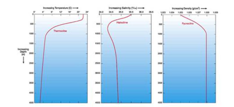
IMPORTANT DEFINITIONS Isohaline:
The spatial distribution of surface salinity of the oceans and the seas is represented by Isohalines which are the lines that join the places of equal salinity at the sea surface.
Thermocline zone: is the layer of ocean between the depth zones of 300 – 1000 m characterised by sharp change of temperature in the vertical section of sea water.
Halocline: denotes a zone of sharp salinity change in the vertical section of the oceans between 300-1000 m depth. Pynocline: is a layer of seawater mass between the depths of 300-1000 m wherein there is sharp change of density in the vertical section of seawater.
Salinometer: is an instrument, which is used to measure salinity of seawater very accurately.
Chlorinity: is the weight of chloride ion in sample seawater, usually in 1 kg of seawater.
16.1 OCEAN CURRENTS
16.2 CLASSIFICATION OF OCEAN CURRENTS
16.3 Origin of Currents
16.4 FACTORS THAT MODIFY OCEAN CURRENTS
1. FACTORS RELATED TO THE ROTATION OF THE EARTH
FACTORS RELATED TO THE OCEANS
i. Temperature Difference
ii. Salinity Difference
iii. Density Difference
3. FACTORS RELATED TO THE ATMOSPHERE
Ocean currents are greatly influenced and controlled by atmospheric conditions like atmospheric pressure and its variation, wind direction, rainfall and evaporation.
i. Air Pressure and Winds
ii. Rainfall and Evaporation
4. FACTORS MODIFYING OCEAN CURRENTS
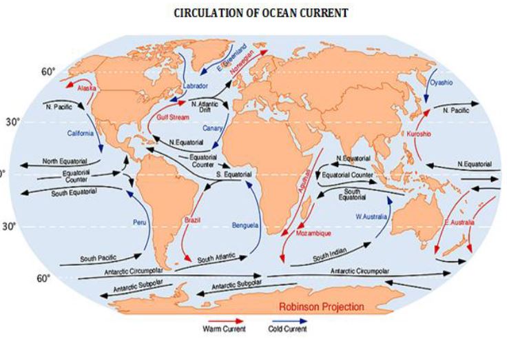
ii. Bottom reliefs
iii. Seasonal variations
16.5 CIRCULATION OF THE ATLANTIC OCEAN
16.6 CIRCULATION OF THE PACIFIC OCEAN
GUANO: The coastal region of Chile and Peru is rich in microscopic marine plants and animals that attract huge shoals of fish. Consequently, millions of sea birds gather here to feed on the fish. Their droppings completely whiten the coastal cliffs and islands, forming thick deposits of guano, a valuable source of fertilizer.
The Peruvian Current eventually links up with the South Equatorial Current and completes the cycle of currents in the South Pacific.
16.7 CIRCULATION OF THE INDIAN OCEAN
In summer from June to October, when the dominant wind is the Southwest Monsoon, the currents are blown from a south westerly direction as the Southwest Monsoon Drift. This is reversed in winter, beginning from December, when the Northeast Monsoon blows the currents from the Northeast Monsoon drift.
16.8 General Circulation of Ocean Currents:
❖ Currents have a tendency to circulate waters in a clockwise direction in the northern hemisphere and in an anticlockwise direction in the southern hemisphere. Due to this generalized pattern of currents, cold currents flow along the western coasts of the continents in the tropical areas while warm currents flow along the eastern margins of the continents in the same latitudes. Along the eastern coasts of the continents in the higher latitudes are found the cold currents and along the western coasts of the continents in the same latitudes are found warm currents. It is due to this factor that the western coast of northern Europe is washed by the warm currents and the eastern coast of Canada experiences a cold current. Similarly, the western coast of North Africa is washed by the cold currents while warm currents are experienced along the eastern coast of southern USA at the same latitude.
16.9 EFFECTS OF OCEAN CURRENTS
1. Modification in the Coastal Climate:
2. Effects on Fishing:
3. Effects on Trade and Navigation:
17. OCEAN TIDES, WAVES & TSUNAMI
17.1 INTRODUTION
High Tide Water: The rise of seawater and its movement towards the coast is called tide and resultant high water level is known as High Tide Water (HTW) Low Tide Water: The fall of seawater and its movement towards the sea is called ebb and the resultant low water level is called Low Tide Water (LTW) Tidal Range: The difference between high tide water and low tide water is called Tidal Range. There is much variation in the height of high and low tides at different places in different oceans because of varying depths of ocean water, geography of sea coasts and coastlines and openness or closeness of the seas.
17.2 Origin of Tides
Perigee: The period of the nearest distance between the moon and the earth (3,56,000 km) is known as Perigee The surface of the earth with its diameter of 12,800 km is 6,400 km nearer to the moon than its centre.
17.3 TIME OF TIDES
17.4 TYPES OF TIDES
i. Spring tides
ii. Neap tides
iii. Tropical & Equatorial tides
iv. Apogean and Perigean tides
v. Daily and Semi-diurnal Tides
vi. Equinoctical Spring Tides
17.5 THEORIES OF THE ORIGIN OF TIDES
Important theories on origin of tides include Equilibrium theory by Issac Newton, Dynamical theory by Laplace, Progressive wave theory by William Whewell, Canal theory by G.B. Airy, Stationary wave theory by R.A.Harris, etc.
17.6 TIDAL BORES
The following conditions favour the occurrence of tidal bore:
17.7 TIDAL CURRENTS
17.8 WAVES
17.9 TSUNAMI
ALEUTIAN TSUNAMI: In 1946, Aleutian earthquake with the magnitude of 7.8 on Richter scale resulted in Tsunami of 35 m in Alaskan and Hawaiian coastal areas.
KAMCHATKA TSUNAMI: In 1952, earthquake of magnitude 8.2 generated Pacific wide Tsunami with a wave height of 15 m.
ALEUTIAN TSUNAMI: In 1957, earthquake of magnitude 8.3 on Richter scale generated a Pacific wide Tsunami of 16 m height and adversely affected Hawaii Islands.
CHILEAN TSUNAMI: In 1960, a strong earthquake of magnitude of 8.6 on Richter scale generated Pacific wide Tsunamis and claimed more than 2,000 lives in Chile.
PAPUA NEW GUINEA TSUNAMI: In 1998, submarine earthquake followed by massive submarine landslides generated 30 m high Tsunami killing thousands of people living in Lagoon.
SUMATRA TSUNAMI: In December 26, 2004, a powerful earthquake of the magnitude of 9 on Richter scale, off the coast of Sumatra with its epicentre at Simeule in Indian Ocean and generated a powerful Tsunami with wavelength of 160 km and initial speed of 960 km/hr. The deep oceanic earthquake was caused due to sudden subduction of Indian Plate below Burma plate. This tectonic movement caused 10 m rise in the oceanic bed which suddenly displaced immense volume of water resulted in Tsunami.
JAPAN TSUNAMI: In 2011, undersea earthquake of magnitude of 8.9 with epicentre 130 km off the coast of Sendai city. Tsunami with the height of 10 m killed more than 10,000 people. Nuclear power plants in Fukushima severely damaged resulting in leakage of radiation. Then, Fukushima power plant evacuated.
CORAL REEFS AND ATOLLS
18.1 CORAL REEFS – INTRODUCTION
18.2 CONDITIONS FOR THE GROWTH OF CORAL POLYPS
18.3 TYPES OF CORAL REEFS
The submarine coral reefs are classified in two ways
TYPES OF REEFS
2. On the basis of location
I. FRINGING REEF
Coral reefs are basically of two types.
II. BARRIER REEF
III.ATOLL
Atolls are divided into
i. True Atoll: It is characterised by circular reef enclosing a shallow lagoon but without island.
ii. Island Atoll: having an island in the central part of the lagoon enclosed by circular reef
iii. Coral Island or Atoll Island: It does not have island in the beginning but later on island is formed due to erosion and deposition by marine waves.
18.4 CORAL REEFS IN INDIA
18.5 CORAL REEFS CONSERVATION
18.6 CORAL BLEACHING
i. Catastrophic bleaching: adversely affecting 95% of shallow water corals in Bahrain, Maldives, Sri Lanka, Singapore and Tanzania
ii. Severe bleaching: accounting for 50-70% death of corals in Kenya, Seychelles, Japan, Thailand and Vietnam.
iii. Moderate bleaching: resulting into 20-50% coral mortality but with quick recovery.
iv. Insignificant bleaching or No bleaching.
CATASTROPHIC CORAL BLEACHING EVENT (1997-98) has been recorded as the most catastrophic event as it accounted for large scale of death of corals in the tropical oceans of 60 countries and island nations, 70% death of corals off the coasts of Kenya, Maldives, Andaman and Lakshadweep islands in the Indian ocean and 75% death in Marine Seychelles and Tanzania.
18.7 CORAL BLEACHING IN INDIA
18.8 CAUSES OF CORAL BLEACHING
18.9 RECOVERY NATURE OF CORAL REEFS
19. MARINE RESOURCES
19.1 INTRODUCTION
19.2 CLASSIFICATION OF MARINE RESOURCES:
Seas and oceans are endowed with different varieties of biotic and abiotic resources of two major sources.
19.2.1 Marine biological resources
(A) Food resources
(B) Non – food resources
Alternatively marine biological resources can also be divided into the following 3 categories.
(A) Plankton communities:
(B) Nekton communities:
(C) Benthos communities:
19.2.2 Marine mineral resources:
(A) On the basis of location
(B) On the basis of nature:
19.2.3 Energy resources:
(A) Conventional energy:
(B) Non – conventional energy:
4. Freshwater resources:
Manufactured water (transformation of saline sea water through the processes of desalinization into potable water)
MARINE BIOLOGICAL RESOURCES (MBR):
1. Plankton Community
2. Nekton Community
3. Benthos Community
FOOD RESOURCES
On the basis of uses, marine food resources are divided into two types.
(i) Protein rich food resources for the use as food for human beings (e.g. fishes),
(ii) Animal feed for domesticated animals.
The following are the main forms of fishing and fish farming:
1. FISHING:
Fishing refers to the direct catching of sea fishes through different means and methods. Sea fishes are grouped in different categories on different bases. On the basis of depth, these are grouped into two categories e.g.
The fishes of clupeiod family account for 45 per cent of the total world catch while gadoid family contributes 15 per cent. Flounders (small flat fishes) contribute15 per cent of total world catch. The remaining 25 per cent is contributed by tuna, IT ackeral etc. (7 per cent), and other types of flat fishes, rose fishes, sea perches, mullets, jacks etc.
On the basis of location sea fishes are grouped in 3 categories viz.
Fishing areas (fisheries) are divided in two categories on the basis of temperature of sea water e.g.
FISHING IN INDIA Fishing has not been developed upto mark in India though its total coastlines run for a length of 7,517km and ideal platforms of continental shelves for fishing are spread over an area of 311,680 square account for 75 and 25 per cent of total annual fish catch has been estimated as 20 – 25 million metric tonnes but actual annual fish catch is less than one million metric tonnes due to a host of factors e.g. tropical climate; lack of ample number of bays, coves, estuaries, backwaters etc. along the coasts; herbivore attitude of majority of Indian population and related less demand of fish as human food; traditional old methods of fish catching and limited means; lack of modern techniques of canning and storage of fishes etc.
2.MARINE FARMING
3. OCEAN RANCHING:
4. WHALING:
The catching of whale is called whaling.Generally, whales are divided into 2 categories Toothed whales and Toothless whales.
Categories
Current Affairs Calendar

| M | T | W | T | F | S | S |
|---|---|---|---|---|---|---|
| 1 | 2 | 3 | 4 | 5 | 6 | 7 |
| 8 | 9 | 10 | 11 | 12 | 13 | 14 |
| 15 | 16 | 17 | 18 | 19 | 20 | 21 |
| 22 | 23 | 24 | 25 | 26 | 27 | 28 |
| 29 | 30 | |||||