SCIENTISTS USE EU SATELLITE TO SPOT AEGEAN SEA LITTER
23, Apr 2019

Prelims level : Environment
Mains level : GS-III Technology, Economic Development, Bio diversity, Environment, Security and Disaster Management
Why in News?
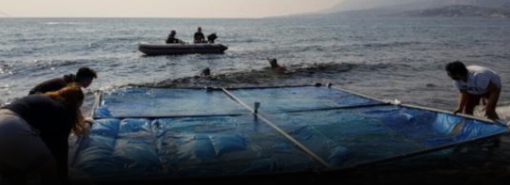
- A team of Greek university students gently deposits a wall-sized PVC frame on the surface before divers moor it at sea.
Marine litter:
- Marine debris, also known as marine litter, is human-created waste that has deliberately or accidentally been released in a lake sea ocean or waterway Floating oceanic debris tends to accumulate at the center of gyres and on coastlines frequently washing aground, when it is known as beach litter or tidewrack. Deliberate disposal of wastes at sea is called ocean dumping.
Aegean Sea:
- The Aegean Sea is part of the Mediterranean Sea.It is between Greece and Anatolia It is connected (attached) in the north to the Sea of Marmara and the Black Sea by the Dardanelles and Bosporus. The large islands of Rhodes and Crete mark the south end.
Details:
- Holding in plastic bags and bottles, four of the 5 metre-by-5-metre (16 foot-by-16-foot) frames are part of an experiment to determine if seaborne litter can be detected with EU satellites and drones.
- “All the targets were carried into the sea, the satellites passed by and we’re ready to fill out the first report
- The results of the experiment—”Satellite Testing and Drone Mapping for Marine Plastics on the Aegean Sea”—by the university’s Marine Remote Sensing
- Group will be presented at a European Space Agency symposium in Milan in May. “Marine litter is a global problem that affects all the oceans of the world,”
- Millions of tonnes of plastic end up in the oceans, affecting marine wildlife all along the food chain
- “Modern techniques are necessary to detect and quantify marine plastics in seawater,” Topouzelis added, noting that space agencies have already been looking into how drones and satellites can help with the clean-up.
- “The main advantage is that we are using existing tools,” which brings down costs and makes it easier to scale up,
- To prepare, the team gathered some 2,000 plastic bottles and lashed them to the frames. Other targets were crafted with plastic bags as these are even harder to spot in the water and usually constitute the deadliest threat to Aegean marine life such as dolphins, turtles and seals.
- “We knew that the European satellite system passes at regular intervals with a spatial resolution of 10 metres.”
- In theory, then, the satellites should be able to detect the floating rafts of plastic the team pushed out to sea.
- Satellite data is provided free from the European Space Agency (ESA) and hours after the overpass targets should be detected from the Sentinel-2 satellite
- The project acts as a calibration and validation exercise on the detection capabilities of the satellites.
- But even if relatively small patches of plastic garbage can be spotted from orbiting satellites, the problem of how to remove it from the sea remains.
- Last year, a giant floating barrier five years in the making was launched off the coast of San Francisco, as part of a $20-million project to clean up a swirling island of rubbish between California and Hawaii.
- But the slow speed of the solar-powered barrier prevents it from holding onto the plastic after it scoops it up.


