

Sinking of Joshimath in Uttarakhand
13, Jan 2023
Prelims level : Climatology
Mains level : GS-III Important Geophysical Phenomena Such as Earth Quakes, Tsunami, Volcanic Activity, Cyclone Etc., Geographical features and their Locations-Changes in Critical Geographical Features (Including Water Bodies and Ice Caps) and In Flora and Fauna and the Effects of Such Changes.
Why in News?
- The Uttarakhand government has banned construction work in and around Joshimath due to land subsidence, which has resulted in cracks in over 560 homes, prompting panicked locals to protest.
Science behind the subsidence:
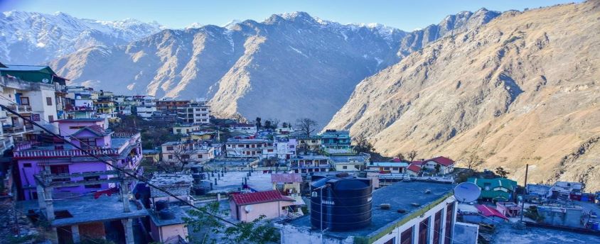
- Location, topography: Also known as Jyotirmath, it is a town (of over 20,000 population) in the Garhwal Himalayas in Chamoli District in Uttarakhand, located on the NH-7 (Rishikesh-Badrinath) at an altitude of 1890
- It is situated in the middle slopes of a hill bounded by the Karmanasa and Dhaknala streams on the west and the east and the Dhauliganga and Alaknanda rivers on the south and the north.
- According to the Mishra Commission report (1976), the first instance of subsidence in Joshimath was reported way back in 1976 and the town is –
- Located on the site of ancient landslides
- Covered with thick layer of overburden material
- The town area is prone to landslides and highly vulnerable to sinking due to scattered and highly weathered gneissic rocks with a low bearing capacity and loose soil due to seepage from streams uphill.
Extreme weather events:
- Flood events of June 2013 and February 2021 (flooding of Rishi Ganga) had adverse impact on the landslide zone as a result of extreme erosion.
- According to the latest satellite data, mountain streams have expanded their channels and changed course, thereby inducing more slope instability in an already fragile belt.
Geology:
- According to the Uttarakhand State Disaster Management Authority (USDMA), Joshimath falls in Zone V of the Seismic Zonation Map and has witnessed several earthquakes of magnitude of less than 5 on the Richter scale.
- Joshimath being on a fault line makes it highly vulnerable to sinking because of tectonic activity.
Unplanned construction:
- The Border Roads Organisation (BRO) is building the Helang bypass that will reduce the distance to Badrinath shrine by about 30 km, using heavy machinery.
- Hydroelectric (HE) schemes have been sanctioned around Joshimath and Tapovan, including the Vishnugad HE Project and a tunnel boring machine (TBM) was employed for excavating the tunnel for the project.
- In 2009, it punctured a water-bearing strata and experts had warned that this sudden and large-scale dewatering of the strata had the potential of initiating ground subsidence in the region.
- Improper water drainage: According to the USDMA, this could be the reason for increase in ground seepage of water from the surface, which is a probable cause for subsidence.
Preventive measures:
- Immediate Measures:
- Relocating residents to a safer place.
- Experts recommend that all development and hydroelectric projects in the region be halted completely.
- Long – Term Measures:
- The town’s planning must be reimagined to accommodate the new variables and changing geographical factors.
- One of the most important factors that needs to be studied and redeveloped is drainage and sewer planning.
- Experts have also suggested replanting in the region, particularly in vulnerable areas, to retain soil capacity.
Way Forward:
- To save Joshimath, the government and civil bodies must work together, with the assistance of military organisations such as the Border Roads Organisation (BRO).


