

Category: Physical Setting
KURIL ISLANDS
27, Mar 2020
Why in News?
- Recently, an earthquake of magnitude 7.5, struck in the northern Pacific, the closest shores on Russia’s far eastern Kuril Islands.
About Kuril Islands:
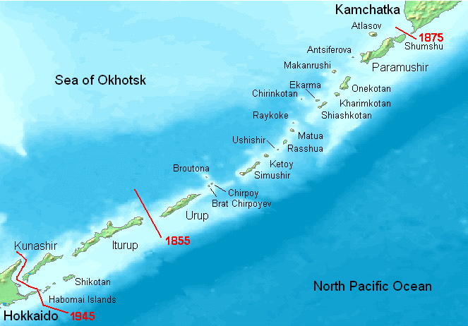
- It is stretched from the Japanese island of Hokkaido to the southern tip of Russia’s Kamchatka Peninsula separating Okhotsk Sea from the North Pacific Ocean.
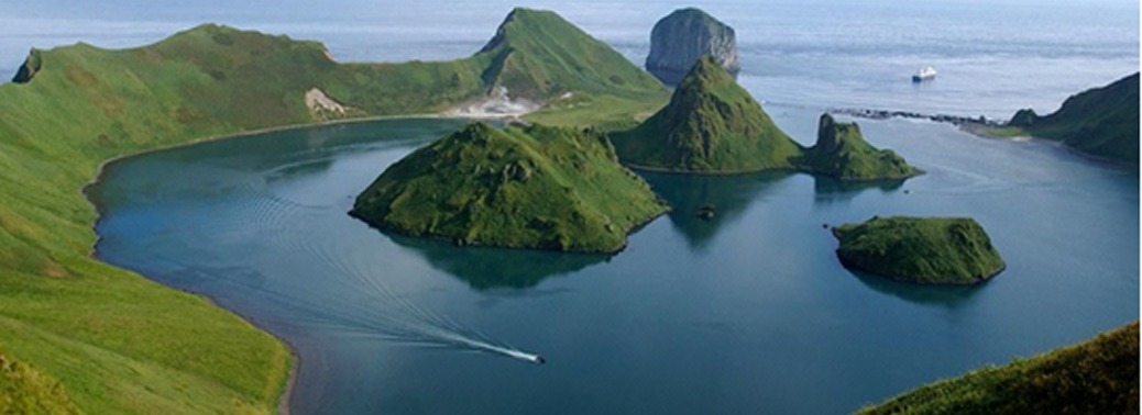
- It consists of 56 islands and minor rocks. The chain is part of the belt of geologic instability circling the Pacific and contains at least 100 volcanoes, of which 35 are still active, and many hot springs.
- It is surrounded by rich fishing grounds and are thought to have offshore reserves of oil and gas. The Rare rhenium deposits have been found on the Kudriavy volcano on Iturup.
- It consists Nickel-based superalloys of rhenium which is used in the combustion chambers, turbine blades, and exhaust nozzles of jet engines.
- Tourism is also a potential source of income, as the islands have several volcanoes and a variety of birdlife.
- Strategic Importance: Russia has deployed missile systems in the region. It also plans a submarine project and intends to prevent any American military use of the islands.
About Sovereignty – Kuril Islands:
- The Islands dispute between Japan and Russia is over the sovereignty of South Kuril Islands.The South Kuril Islands comprises Etorofu island, Kunashiri island, Shikotan island and the Habomai island. These islands are claimed by Japan but occupied by Russia as successor state of the Soviet Union.
- These islands are known as Southern Kurils by Russia whereas Japan calls them Northern Territories.
About Ainu People:
- It was originally inhabited by the Ainu people, and they were later settled by the Russians and Japanese, following several waves of exploration in the 17th and 18th centuries.
- The Ainu or the Aynu, also known as the Ezo in the historical Japanese texts, are an indigenous people of Japan and Russia.
- Treaty of Shimoda (1855): It is concluded between Japan and Russia, which gave control of the four southernmost islands to Japan and the remainder of the chain to Russia.
- Treaty of Saint Petersburg (1875): It is signed between two countries, Russia ceded possession of the Kurils to Japan in exchange for uncontested control of Sakhalin Island.
- Yalta Agreement (1945): As part of the Yalta agreements the islands were ceded to the Soviet Union, and the Japanese population was repatriated and replaced by Soviets.
- San Francisco Peace Treaty (1951): It is signed between the Allies and Japan, states that Japan must give up “all right, title and claim to the Kuril Islands”, but it also does not recognize the Soviet Union’s sovereignty over them.
- Japan-Soviet Joint Declaration (1956): It restored diplomatic ties between Japan and Russia by Japan-Soviet Joint Declaration. During that time, Russia offered to give away the two islands closest to Japan. But the offer was rejected by Japan as the two islands constituted only 7% of the land in question.
- However, Russia indicated that the joint declaration signed by Japan and the Soviet Union in 1956 neither mentions a basis for returning Habomai and Shikotan nor clarifies which country has sovereignty over the islands. Further, in 2019, Japanese PM made it clear that the country is not in the favour of withdrawing control over the Islands. Japan also believes that the islands are the inherent part of the nation’s territory. Therefore, Japan mentioned that it aims to sign the peace treaty after the territorial issue is resolved.
INDIA’S FOREST COVER INCREASED
22, Jun 2019

Context:
- Forest cover of India increased by 2%
State of Forests Report:
- Is a biennial publication of FSI, an organization under MoEFCC, GoI. ISFR 2017 is the 15th in the series since 1987
- Forest cover of the country is mapped through indigenous RESOURCESAT -2 satellite
- data with a LISS III sensor.
- The LISS-III (Linear Imaging Self Scanning Sensor) sensor is an optical sensor working in four spectral bands (Green, Red, near Infrared and short-wave infrared). It covers a 141km-wide swath with a resolution of 23 metres in all spectral bands.
- It provides the estimates of
-
- Growing stock within and outside the forest areas
- Special thematic information on forest cover in hill,
- tribal and north eastern states
- Carbon Sink
- Bamboo
- Mangrove cover
Recorded Forest Area and Forest Blank
- The area recorded as “forests” in the Government records is called Forest Area or Recorded Forest Area.
- The patches within the forest area which have little or no trees are called “Forest Blank”
The report for the First Time Contains:
- Information on decadal change in water bodies in forest during 2005-2015
- Forest fire
- Production of timber from outside forest
- State wise carbon stock in different forest types and density classes
Classification of Forest Cover into density classes
- Very Dense (Canopy Density > 70%)
- Moderate Dense (Canopy Density 40% to 70%)
- Open Forest (Canopy Density 10% to 40%)
- Scrub: Degraded forest lands (Canopy density <10%) Non-forest: Lands not included in above classes
Top Five States / UTs that have shown the maximum increase in forest cover are:
- Andhra Pradesh (2141 sq.km)
- Karnataka (1101 sq.km)
- Kerala (1043 sq.km)
- Odisha (885 sq.km)
- Telangana (565 sq.km)
Top 5 States where Forest cover has Decreased are:
- Mizoram (531 sq.km)
- Nagaland (450 sq.km)
- Arunachal Pradesh (190 sq.km)
- Tripura (164 sq.km)
- Meghalaya (116 sq.km)
Top three states/UTs having the largest forest cover in terms of area are:
- Madhya Pradesh (77414 sq.km)
- Arunachal Pradesh (66964 sq.km)
- Chhattisgarh (55547 sq.km)
Important Terms: / Canopy and Canopy Density:
The cover of branches and Foliage formed by the crown of trees is called Canopy. The percentage area of land covered by the canopy of trees is called Canopy density.
Forest Cover:
- All lands which are More Than 1 Hectare in Area and with a Canopy density of more than 10% irrespective of the ownership and legal status is called Forest Cover.
- Also, it does not make any distinction whether the forest is natural or manmade forest, government or private, recorded or not recorded. It includes bamboo, orchards, palm etc.
Carbon Stock:
- It is defined as the amount of carbon stored in the ecosystem of the forest especially in living biomass and soil
EYE ON THE MONSOON
21, May 2019
Why in News:
- The India Meteorological Department has forecast normal rainfall of 96% of the long period average of 89 cm rain in Kerala. It has also signalled a significant possibility of a deficit.
Details:
- India waits for the arrival of the annual summer monsoon, hopes are high for normal rainfall that is so vital for agriculture, the health of forests, rivers and wetlands.
- The monsoon is crucial for the 60% of gross cropped area in farming that is rain-fed and in the assessment of the National Commission on Farmers which has 45% of agricultural output. Some aerosols suppress the rainfall and disperse it across the land, causing long breaks in precipitation, while others absorb heat and lead to a convection phenomenon that increases rainfall in some places.
Way forward:
-
The southwest monsoon is a determinant of India’s overall prosperity, and sustained efforts
to make the best use of rainfall are absolutely important for farms, cities and industry. - There has been a 52% decline in groundwater levels. State governments should have pursued the setting up of new recharging wells and made improvements to existing ones on a war footing.
- There is a lag in building structures to harvest surface water and helping farmers raise the efficiency of irrigation.
- India needs to clean up its act on rising industrial emissions, and burning of fossil fuels and biomass in order to improve the stability of the monsoon.
-
NITI Aayog says that freshwater availability for households, account for 4% of available supplies, besides 12% used by industry.
Urbanisation trends and the severe water stress that residents experience underscore the need for mandatory rainwater harvesting policies and augmented efforts by States to preserve surface water by building new reservoirs.
Monsoon:
- Monsoon is the lifeline of Indian economy as 2/3rd of it depends on farm income and rain is the only source of irrigation for over 40% of the country’s cropped area.
- Over 70% of India’s annual rainfall occurs in July-September monsoon season.
- A good monsoon increases crop productivity, raises farm income and drives the economy while, a weak monsoon inflates food prices and harms the economy.
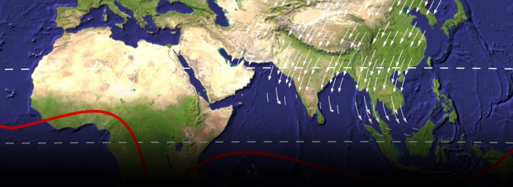
- Monsoon refers to the seasonal reversing wind accompanied by precipitation.
- It occurs due to a difference in temperature between the landmass and the ocean. Major monsoon of the world are West African and Asian-Australian monsoons.
- Southwest monsoon accounts for over 80% of rainfall in India. Monsoon impacts Indian economy- agriculture, industry and society as a whole. It brings respite from heat and transforms large part of semi-desert areas into green land.
- Crops specially like cotton, rice, oilseeds, and coarse grains depends heavily on rains.
- Monsoons are often associated with conditions like ‘El Nino’ (Spanish for ‘Little Boy’) that occurs every 2 to 7 years and La Nina. It is caused by unusual warming in Eastern tropical Pacific Ocean and reversal of prevailing winds in the region. El Nino can trigger above average rains in northern Peru & draught in Southeast Asia, Australia and India.
Southwest monsoon/ Indian monsoon:
- Indian subcontinent has a large heated landmass during the summer months (April to September), and a cooler water mass in the form of Indian Ocean.
- This causes a temperature difference, which creates a pressure gradient and drives moisture laden winds over Indian subcontinent. Impact of this monsoon is felt in India, Sri Lanka, Bangladesh and Myanmar and as far north as in China’s Xinjiang.
- It has two branches:
The Arabian Sea branch:
- It first hits the Western Ghats and Kerala gets the first rain in India. It causes rain in the coastal areas of Konkan and Goa
As it moves northwards, but eastern part of the Western Ghats do not receive much precipitation.
The Bay of Bengal Branch:
- It picks up moisture-laden winds from Bay of Bengal and moves towards North-East India and Bengal. The Himalayas act as a barrier for them and thus, rain occurs in Indo- Gangetic plains, Meghalaya, etc.
Northeast monsoon/ Retreating monsoon:
- The cycle is reversed during colder months (October to April). Wind blows from cooler landmass (Himalayas and Indo-Gangetic plain) towards Indian ocean (south of Deccan). This causes precipitation over the oceans and in regions like Tamil Nadu.


