

SPACE SCIENCE
INTRODUCTION
- Space is a 3-dimensional boundless extent within which matter is physically extended and the objects and events that occur have position and direction relative to each other.
Outer Space
- It is that part of the space that lie beyond Earth and its atmosphere. In 1929 U.S based astronomers Edwin Hubble proposed the ever- exploding phenomenon of universe. It was a hot mass of super hot and super dense substances which exploded and got fragmented with a big bang to result in expanding of universe. Galaxies are huge congregation of stars held together by force of gravity. The Milky way is our home Gallexy
SPACE RESEARCH
- It Involves dual-use tech, which means tech that has its application in both Civilian and defence sector. It has both Political and Strategic significance so is developed indigenously. Indian Space Research also involves dual use technology that is used for both civilian and defence sector. Six countries which possess such technology are Russia, U.S.A EU, China, Japan and Israel.
Indian Space Research Programme
- Driven by the vision of Vikam sarabhi, it aims to promote the development and application of Space science and technology for social- economic benefit of the country.
Objectives
- To utilise the outer space for peaceful purpose
- To establish operational space services in a self- reliable manner.
- Indian Space Research programme primarily involves designing and fabrication of satellites and development of launch vehicles.
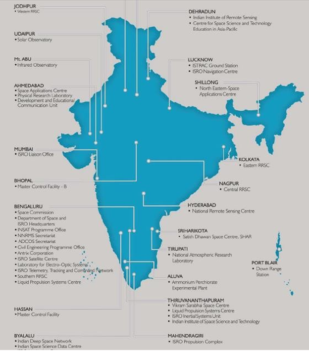
Organisational Set-up
- Indian National Committee for Space Research (INCOSR) came into being in 1962. The Indian Space programme was institutionalised in Nov1969 with the formation of Indian Space Research Department or Space was formed in1972 and ISRO was brought under it. Dept. of Space is part of ministry science and Technology is the nodal agency in the field of space in India, formulating and providing polices involving space research. It coordinates the activities of various institutions that are involved in space research and extend financial assistance for conducting space research.
- ISRO satellite centre,Bangalore
- Vikram Sarabhai satellite centre, Thumba Thiruvananthapuram (VSSC)
- Sathish Dhawan Space Centre, Sriharikota, A.P (SDSC)
- Space Application Centre, Ahmedabad.
ISRO satellite centre Bangalore
- ISRO Satellite Centre (ISAC), Bengaluru, is the lead centre of ISRO for design, development, fabrication and testing of all Indian made satellites. As a sequel to its mandate of spacecraft realisation, the Centre is engaged in the development of cutting-edge technologies of relevance to its satellite building activities and setting up of infrastructure for design, development, fabrication and testing of spacecraft. Over the past four and a half decades, ISAC has developed intellectual capital in a wide spectrum of knowledge domains of spacecraft technology.
- ISRO Satellite Integration and Test Establishment (ISITE) is equipped with the state-of-the-art clean room facilities for spacecraft integration and test facilities including a 6.5 Metre thermo vacuum chamber, 29 Ton vibration facility, Compact Antenna Test Facility and Acoustic Test Facility under one roof. Assembly, Integration and Testing of all Communication and Navigation Spacecraft is carried out at ISITE.
- A dedicated facility for the productionisation of standardised subsystems is also established at ISITE. Since its inception in 1972, the centre has built 72 spacecraft varying from scientific/experimental satellites to the state-of-art operational satellites in the areas of Communication, Navigation, Remote sensing and Space Science.
VSSC Thiruvananthapuram
- Vikram Sarabhai Space Centre (VSSC) at Thiruvananthapuram is the lead centre for the design and development of launch vehicle technologies for the Indian Space Programme. The major programmes at VSSC include: Polar Satellite Launch Vehicle (PSLV), Geosynchronous Satellite Launch Vehicle (GSLV) and Rohini Sounding Rockets as well as the development of Geo- Synchronous Satellite Launch Vehicle
- (GSLV) – Mk III (LVM-III), reusable launch vehicles, advanced technology vehicles, airbreathing propulsion and critical technologies towards human
- The Centre pursues active research and development and has developed core competence in various disciplines including aeronautics, avionics, materials, mechanisms, vehicle integration, chemicals, propulsion, space ordnance, structures, space physics and systems reliability. The Centre undertakes crucial responsibilities of design, manufacturing, analysis, development and testing related to the realisation of subsystems for the different missions. These are sustained by activities towards programme planning & evaluation, technology transfer, industry coordination, human resources development and safety. Planning, execution and maintenance of all civil works related to the Centre is also carries out. The Centre depends on administrative and auxiliary services for support VSSC has extension Centres at Valiamala housing major facilities of mechanisms, vehicle integration and testing and at Vattiyoorkavu for the development of composites. The Ammonium Perchlorate Experimental Plant (APEP) has been set up by VSSC at Aluva near Kochi.
(SHAR) Sriharikota
- It is the satellite launching station in the country. It was earlier known as Sriharikota High Altitude Range (SHAR) and renamed Sathish Dhawan Space Centre in September 2002. Sathish Dhawan was the former chairman of ISRO also worked as secretary in the Dept of space
- SDSC at Sriharikota, with two launch pads, is the main launch centre of ISRO that carries out launch operations. The mandate for the centre is (i) to produce solid propellant boosters for the launch vehicle programmes of ISRO (ii) to provide the infrastructure for qualifying various subsystems and solid rocket motors and carrying out the necessary tests (iii) to provide launch base infrastructure and (iv) for assembly, integration and launching of satellites and launch vehicles.
- The Centre is augmenting the infrastructure to meet the requirements of increased launch frequency of 5-6 launches per year. The present Vehicle Assembly Building (VAB) is being used for integration of PSLV/GSLV/GSLV Mk-III (LVM3) launch vehicles for launching from the Second Launch pad. Second Vehicle Assembly Building (SVAB), integrated with existing rail track leading to Second Launch Pad, is planned to augment the launch infrastructure and provide redundancy to existing critical infrastructure. SDSC has a separate launch pad for launching the sounding rockets. The centre provides the necessary launch base infrastructure for sounding rockets of ISRO and for assembly, integration and launch of sounding rockets and payloads. Thus 2nd launch pad is more sophisticated than earlier one since on this launch pad the launch vehicle does not require to be anchored as it was used to be earlier. In case of an impeding storm the launch vehicle can be easily moved to a safe place. More over, this launch pad can be easily prepared it would enable ISRO to launch satellite frequently.
Space Application centre Ahmadabad
- It is responsible for conceptualisation, planning and execution of space research projects. Space Applications Centre (SAC) at Ahmedabad is a unique centre dealing with a wide variety of activities from payload developments to societal applications, thereby creating a synergy of technology, science and societal applications. The centre is responsible for the development, realisation and qualification of communication, navigation, earth observation and planetary payloads and related data processing and ground systems in the areas of communications, broadcasting, remote sensing, disaster monitoring/mitigation, etc. It is playing an important role in harnessing space technologies for a wide variety of applications for societal benefits.
- In order to carry out the above tasks, SAC has highly sophisticated payload integration laboratories, electronic and mechanical fabrication facilities, environmental test facilities, systems reliability/assurance group, image processing and analysis facilities, project management support group and a well-stocked library. SAC has also put adequate emphasis on and practicing outsourcing and indigenous development of technology and Vendors
Liquid Propulsion Systems Centre (LPSC)
- Liquid Propulsion Systems Centre (LPSC) is the centre of excellence in the area of Liquid and Cryogenic Propulsion for ISRO’s Launch Vehicle and Spacecraft programmes. The activities are spread across Valiamala / Thiruvananthapuram and Bengaluru centres
- LPSC Valiamala is the Headquarters and is responsible for R & D, system design / engineering, delivery of liquid and cryogenic propulsion systems, control components & modules and control power plants. LPSC Bengaluru focuses on the design and development of satellite propulsion systems and production of transducers/sensors.
ISRO Propulsion Complex (IPRC)
- The activities carried out at IPRC, Mahendragiri are: assembly,integration and testing of earth storable propellant engines, cryogenic engines and stages for launch vehicles; high altitude testing of upper stage engines and spacecraft thrusters as well as testing of its sub systems; production and supply of Cryogenic propellants for Indian Cryogenic rocket programmes, etc. IPRC is responsible for the supply of Storable Liquid Propellants for ISRO’s launch vehicles and satellite programmes. IPRC delivers quality products to meet the zero defect demand of ISRO space programme ensuring high standards of safety and reliability. It also carries out Research & Development (R&D) and Technology Development Programmes
- (TDP) towards continual improvement of its contribution to Indian space Programme
Antrix Corporation Limited
- Antrix Corporation Limited, Bengaluru is a wholly owned Government of India Company under the administrative control of the Department of Antrix Corporation Limited was incorporated in September 1992 as a private limited company owned by Government of India as a Marketing arm of ISRO for promotion and commercial exploitation of space products, technical consultancy services and transfer of technologies developed by ISRO. Another major objective is to facilitate development of space related industrial capabilities in India.
- As the commercial and marketing arm of ISRO, Antrix is engaged in providing Space products and services to international customers worldwide. With fully equipped state-of-the-art facilities, Antrix provides end-to- end solution for many of the space
- products, ranging from supply of hardware and software including simple subsystems to a complex spacecraft, for varied applications covering communications, earth observation and scientific missions; space related services including remote sensing data service, Transponder lease service; Launch services through India’s operational launch vehicle PSLV; Mission support services; and a host of consultancy and training Services
TYPES OF ORBITS Near Earth orbit
- It lies at a height of about 400km above the surface of Earth. Experimental satellites experience maximum gravitation force, so burns more fuel and lifespan is about two years. The 1st artificial satellite was launched in 1957 from Russia named Sputnik-I. Various other experimental satellites launched by India in NEO are Aryabhatta, Bhaskara, Rohini
Low Earth orbit
- These are located at a height of 900km from the Earth’s surface. It is the circular orbit in which operational remote sensing satellites are launched with the help of polar satellite launch vehicles which inject these satellites at a velocity of 7.5 km/sec. The life span of satellite is generally 7-10 years. India has launched Indian Remote Sensing Satellite series into LEO. Technology Experimental Satellites (TES) has launched by PSLV C-3 in 2001 was the only experimental satellite launched in this orbit by India.
Geostationary orbit
- It is the height of about 30,000km from the equator in this orbit; geostationary satellites are launches by GSLV at an injection velocity of 10 km/sec. Geostationary satellites follow circular orbit from West to East above the Equator at the same speed as that of Earth’s surface. Thus a geostationary satellite is synchronised in its orbit around the Earth with the rotation of Earth on its axis. Geostationary orbit is the most crowded of all orbits around the Earth as they have to be over equator only. At the height of 36,000km geostationary satellite surveys nearly 1/3rd of the Earth’s surface so there is a need of three geostationary satellites to cover the entire surfaces of Earth
Transfer Orbit
- It is an intermediate orbit into which a satellite is released from which the satellite will subsequently lift itself up by making use of its propulsion system.
Polar Transfer orbit
- It is an elliptical orbit at height 100km below LEO/ polar orbit. Remote sensing satellite launched into polar Transfer orbit first then using its own propulsion system it lifts itself to the designated
- Polar orbit is an orbit in which satellite moves pole to pole thus covers entire surface of Earth at a given period of time
Geostationary Transfer orbit
- It lies at a height of 2000km below the Geostationary orbit, Geostationary satellite are first launched in Geo- stationary transfer orbit then lifts themselves to Geo- stationary orbit using their own propulsion system.
Satellite Launching Stations
They are generally located on the East Coast – as close as possible to the Equator because Eastern side of East Coast – Water body. (E.g.) Cape – in S.E. coast, in Florida, Kooroe in N.E. Coast of French Guiana, South America.
- As the Earth rotates from West to East, the launch vehicle also Move in the same direction, this launching a satellite towards the east from a site on the equator means the Earth’s rotation.
- Generally, in the eastern side of west coast final velocity lays landmarks inhabited by people occupied by properties. In case of a mishap occurs and if launch vehicle is launched from launching station of west coast, it may result in loss of life and destruction of property
- There are close to equator, because radius of Earth bulges out nearly 21.5 km. Moreover gravitational pull of Earth is very less for these satellites which can be easily launched without attractive pull
TYPES OF SATELLITES
-
Remote sensing satellites
- Space based Earth observation system able to collect info. about any object on / closer Earth’s surface by radiating, reflecting or scattering of radiation by the object. – Remote sensing satellites is able to provide a synoptic view of large areas of Earth and collect, distribute Multiple data including ecological, geographical, geological and meteorological data within a short period of time. – RS satellites is a key player in countries planning infrastructure development and forms integral part of country’s natural and renewable resources management by supplying data to Natural Resource Management System in Bangalore
- RS Satellite data is 15 times cheaper, far more accurate and systematic. National Remote sensing agency, Hyderabad is the nodal agency for reception, processing and spread of data from All India RS satellites like CARTOSAT I, II Resource sat I. As per the RS data policy, National RS Agency is the national acquisition / distribution agency for all satellite data within India.
Fields of Application of RS Data:
Data from RS Satellites can be used as
- In field of agriculture, it can help in assessment of net crop area, crop protection forecast extent of disease application in crops, availability of water for irrigation in difference reservoirs and movement of pests and locusts. PC has divided the country into 15 Agro climatic zones to increase agricultural productivity using remote sensing data obtained from IRS-IA & IRS-ID.
- In the field of forestry, it can help in assessment of extent of forest cover, distribution of animal and plant species, migration of animals, forest fires and their management.
- In the field of coastal studies and fisheries, it can help locating shoals of fish their better harvesting.
- In the field of weather forecasting, RS data can help in accurate, short-term weather forecasting.
- In the field of Planning & Management, RS data can be used for Urban Planning, flood- prone area identification and consequent suggestion for mitigation
- RS satellite data can help in strengthening Military Potential RS satellites having less than 5m resolution power can help in tracking troop movement and also help in locating static Military installations (RS) Military – Air base and naval base. IKONOS launched in Sep. 1994 by USA. Indian CARTOSAT – 2, 2A having resolution power of less than 1m.
9.4.1.2 Indian Space System:
- ISRO has established 2 major space systems
- Indian National Satellite System (INSAT) for Communication, TV Broad casting and Meteorological services.
- Geo stationary satellites
- Indian Remove sensing satellite system, for resource monitoring and ISRO has developed 2 SLV – PSLV &GSLV to place Indian Remote Sensing Satellites and Indian National Satellite in their required orbits.
9.4.1.3 Indian Remote Sensing Satellite System:
- IRS satellites are series of Earth observation Satellites build, launched and maintained by ISRO as part of Indian Space Programme. It is the largest constellation of RS Satellites for civilian use in operation today in the world. Data from RS Satellites are used for various applications of resource survey and management and the National Natural Resources Management System.
- The initial version of IRS satellites were named ad 1-A, 1-B, 1-C, 1-D and later versions are named based on the area of application including Oceansat, ResourceSat and Cartosat
- With the launch of RISAT-1 the constellation now has 12 Satellites in operation, all these are places in Polar Sun Synchronous orbits & provide data in a variety of spatial, spectral and temporal resolutions to enable several applications to be undertaken relevant to the national Development
Re-Entry Technology:
- It demands re-entry of fast- moving satellite (20,000 km/hr space) in Earth’s atmosphere at an appropriate angle as friction with Earth’s atmosphere generates a scorching heat of the intensity of about 20000 degree Celsius. Thus, satellite was provided with carbon phenolic materials and silica tiles on its outer surface to protect it from the heat.
Re-usable Launch Vehicle:
- It is an amalgamation of a rocket in an aircraft. It will be launched from a space station to go into space to either place / repair a satellite in orbit and then like an aircraft, it’ll glide back to land on an air strip on Earth’s surface. Therefore, it can be used many times.
Significance:
- At present, the cost of launching a satellite is $13,500 per kg. 75% of it is utilised in making rocket engines of the launch vehicle which sequencially fall into sea and could not be recovered. Because of increasing cost of launching satellite, ISRO is working on a re-usable launch vehicle and demonstrated successfully by Space Capsule Recovery Expt. The acquiring of this building a Re-useable Launch Vehicle will significantly decrease the cost of launching the satellite to $ 1000 / kg. Payload. With the success of SRE – ISRO is about to come with Reusable Launch vehicle (A Technology Demonstrator) RL – (TD), by end of 2008. India is also planning to develop nuclear propulsion and even electronic propulsion to use in its launch vehicle.
Geo-Stationery Satellites:
- Multi purpose satellites launched at the height of 35876 km from the Equator by GSLV. In its orbit, geo- synchronous satellite covers a circular path moving from W to E at the same speed as that of Earth’s rotation. Therefore, Geo- synchronous satellites appear to be stationery from Earth’s Surface and hence called Geo- Stationery Satellite.
- Geo-synchronous satellite confers the following abilities to a country.
- Tele communication
- TV Broad casting
- Weather forecasting
- Disaster forewarning
- Data Relaying
- Search and Reserve operations
- In data relaying for large volumes of data is transferred at high speed enabling establishment of internet services, networking of banks, stock markets and other financial
- In Disaster forewarning, Geo- synchronous satellite intimates various disaster forewarning centres located along the – of the country providing information regarding formation of a trough its development in to a depression and then, formation of a cyclonic storm. Therefore, it provides accurate information of speed and direction of cyclonic storm preventing destruction of property and loss of life
- Under search and rescue formations, satellite on the basis of distressed signals received provides accurate information regarding latitudes, longitude and altitudes of the place from where distressed signals originated and – helping in rescuing. So Geo-synchronous satellite is an eye in the sky
LAUNCH VEHICLES
- LV is a rocket used to carry a payload from the Earth’s surface into outer space. It helps in placing either an experimental / operational RS or Geo Synchronous Satellite in its designated
Important Components of a Launch Vehicle:
AcceleroMeter:
- Monitors the acceleration of the Launch Vehicle right from the time of its lift-off.
Gyroscope:
- Considered as the eye and the ear of the Launch Vehicle as it helps in determining the position and velocity of the Launch Vehicle. It also provides information regarding orientation of Launch Vehicle.
C-Loop System :
- Is a combination of computers present on board i.e. onboard computer panel system which on the basis of the data provided by accelerometer and gyroscope, guides the vehicle rights from its lift-off and it also controls the orientation of the vehicle in its entire three axes.
Propellant:
- A mixture of fuel and oxidiser. 50% of the weight of Launch Vehicle is the propellant 85% of the propellant is oxidiser. Therefore, payload on the Launch Vehicle is hardly a fraction of weight and Launch Vehicle fuel can be solid / liquid
Solid Fuel:
- Less Corrosive, so has longer shelf life and can be easily transported. Burns rapidly generating greater thrust which is essential for easy lift-off of the Launch Vehicle by over coming gravitational force and therefore 1st stage of Launch Vehicle is also solid fuel based
Disadvantages:
- It reduces payload fraction of LV as the solid fuel is bulky
- Solid fuel based engine, once shut off cannot be re-started andtherefore, it does not provide enough flexibility to the Launch Vehicle to satellite in the pre- assigned orbit.
- (E.g.) Hydroxyl Terminated Poly Buta diene (HTPB)
Liquid Fuel:
- Liquid Fuel based engines can be restarted once shut-off providing greater flexibility to Manouvere the satellite. It is more compact, occupies less space and has got greater payload fraction
Disadvantages:
- Corrosive in nature so can’t be stored for long time in fewer temps. It is also difficult to be transported.
INDIA’S LAUNCH VEHICLES
SLV:
-
- It is 4-stage with all solid fuel based. It was successfully tested in July, 1 Payload capacity 40-50. It can place experimental satellite in Near Earth Orbit. Its successful launch conferred on India, ability to develop short and intermediate range ballistic missile.
ASLV:
- Augmented Satellite Launch Vehicle.
- Successfully test fired in May, 1992. It is 5-stage rocket, all solid fuel based. It can lift a satellite of up to 150 Kg. to NEO. H helped in placing ROHINI and SROSS (stretched Rohini Satellite Series) in NEO
PSLV:
- It is an expandable Launch Vehicle operated by ISRO. It was developed to allow India to launch its IRS satellites. It is 4- stage Launch Vehicle in which the 1st and 3rd stages used solid fuel and 2 and 4th stage used liquid fuel
1st Stage – HTPB fuel:
- Motor case is made of an advanced allay of Iron and Nickel known as MARAGING Steel. This alloy has reduced the weight of 1ststage to 1/3rd.
2NDStage:
- Liquid fuel based
- Used in Vihar Engine
- Unsymmetrical dimethyl Hydrazine as fuel
- Nitrogen Oxide as Oxidiser.
3rdStage:
- Solid fuel based, made up of Kevlar Fibre, Special alloy of Iron and Nickel which is light weight, strongly reducing the weight of 3rd
4th Stage:
- Liquid fuel based hydrazine and mixed oxides Nitrogen as Oxidiser.
- PSLV has conferred upon India, the ability to develop inter- continental Ballistic Missile.
GSLV:
- It is the 4th generation LV designated for launch of geo- stationary satellites. It is 3-stage LV, 49m tall
1stStage:
- GS-1 solid propellant
2nd Stage:
- GS – 2 Liquid propellants
3rdStage:
- GS – 3. Cryogenic stage with re- startable engine.
Cryogenic Stage :
- Uses Liquid Hydrogen at -253oC and Liquid Oxygen at -183oC as oxidiser.
- A cryogenic engine is more efficient and gives 1½ times move thrust to every kg of propellant burnt than solid / liquid propellant, while weighing 50% less thereby enhancing the payload capacity. India has been acquiring the Cryogenic engine and technology from Russian Space Agency.
- India has been developing Geo- Synchronous Satellite Launch Vehicle in the form of 3 generations.
- 1st Generation – Geo- Synchronous Satellite Launch Vehicle have been developed from Geo-Synchronous Satellite Launch Vehicle Mark-I. GSLV-D1 which placed GSAT-1 in April 2001. GSLV-D2 PLACED GSAT-2 in May, 2003. It is capable of launching 1.5 ton (1500 kg) in geo-stationery transfer orbit.
- 2nd Generation – Geo- Synchronous Satellite Launch Vehicle Mark – II. This variant can carry 2.5 tonnes weight into Geo-stationary Transfer Orbit. The 2 operational flight of GSLV Mark-II have been tested
- GSLV – F01: 1SToperational flight conducted on September 28, 2004 placing EDUSAT
- GSLV – F02: Unsuccessful in launching INSAT –Both GSLV Mark I & II used Cryogenic engine tech imported from Russia
3rd Generation GSLV Mark III
- Under development at VSSC, since October 2002, it will be the nearest and most powerful Launch Vehicle of India which could place 4 to 5 tonnes of Geo- Stationary Satellites in Geo- Stationary Transfer orbit and up to 10 tonnes of RS satellite in LEO. Initially India used Russian cryogenic engines, but in August 04, 2008, India successfully tested indigenously developed cryogenic engine for 8 min. at Liquid Propulsion Centre, Mahendragiri, Tamil Nadu as a part of Cryogenic Upper Stage Project. This successful test is a major milestone as it will enable India to launch about 4 ton. heavy Geo-Stationary Satellite in Geo Stationary Orbit.
Significance of Cryogenic technology
- It minimises the space occupied by fuel
- It enhances the number of combustion of fuel
- Cryogenic technology enables the rocket to carry heavier payloads without any increase in size of rockets. Indian space agency is also looking at semi-cryogenic fuel which will use liquid O2 as oxidiser and kerosene replacing liquid H2 as the fuel. It is aviation grade kerosene highly refined paraffin which will reduce the cost drastically. Cryogenic means low temperature. The rocket engine that makes use of liquid fuel and extremely low temp is called cryogenic engine.
INDIA’S MOON MISSION
- Chandrayaan-I
- ISRO launched its ambitious mission to the moon by an unmanned lunar spacecraft Chandrayaan-I with the help of PSLV-C11 on November 2 Chandrayaan-I orbits the surface of moon from the height of 100km help in understanding physical and chemical composition of moon and its crator history.
- Hyper spectral imager will perform mineralogical mapping and Terrain mapping camera with 5m resolution use to produce high resolution map of the moon. Lunar Laser ranging instrument will determine the surface topography High energy x-ray spectrometer will help in radioactive elements to be probed. Moon impact probe will search for surface water in the form of ice on the moon.
Chandrayaan -II
- ISRO is planning a 2nd version of Chandrayaan named Chandrayaan-II under which a motorised rover will land on the moon 2015 as part of the 2ndChandrayaan mission. The rover will be displayed to move on wheels on the lunar surface and picks up samples of soil, rocks do insitu chemical analysis sent the data to the mother spacecraft Chandrayaan -II which will be orbiting above which in turn will transmit the data to the ground. Chandrayaan- II will consist of the spacecraft itself a landing platform with the moon rover. The platform with the rover will detach from the orbiter after the spacecraft reaches its orbit above the moon land on lunar soil. Then the rover will roll out of the moon
GLOBAL POSITIONING
SYSTEM
- It is a satellite based radio navigation system that gives accurate information to its users about the latitude, longitude and altitude on Earth’s surface helping aircraft ships submarines missile tanks, Artillery guns marking their positions accurately enhancing their striking capability so that they strike accurately.
GEOGRAPHIC INFORMATION SYSTEM
- A geographic information system (GIS) is a computer system designed to capture, store, manipulate, analyze, manage, and present all types of geographical data
GLONASS [Global Navigation satellite system]
- It is a radio based satellite navigation system a version of GPS developed by Russia. The fully operation GLONASS would require a constellation of 24 Geo stationary satellites. The 1st generation included URBAN-M/ GLONASS -M series with a lifetime of 7years. The 3rd generation satellites are called URAGAN-K/ GLONASS-K Satellites with lifetime of 10-12 years. As of Oct 2011 GLONASS system remains fully operational with 24 operational satellites. In 2005 an agreement between India and Russia that India would share some of the developed costs of GLONASS-K series launched two of the new satellites (GLONASS-K series from India).
GALILEO
- EU has also been developing its own GPS called GALILEO satellite navigation system launched its first test satellite was launched in April -08 with the success of these two test satellites, it will launch a full fledged GPS with 30 Geostationary satellites in the Geostationary orbit. This will end EU reliance on GPS system which is controlled by US military. It will be under civilian control will extend to its user an accuracy level up to 1m as compared to 5m accuracy level provided by GPS of USA.
- In the 11th FYP 475 VRC’s have been linking rural and semiurban blocks in future an exclusive satellite Transponder will be allotted to VRC’s, with adequate between to provide other satellite based services such as mobile communication, multimedia, Emergency supportcommunication, disaster management etc.
9.11 GPS AIDED GEO AUGMENTED NAVIGATION (GAGAN)
- GAGAN is a Satellite Based Augmentation System project, which is jointly being implemented by Indian Space Research Organisation and Airport Authorities of India. The main objectives of GAGAN are to provide Satellite-based Navigation services with accuracy and integrity required for civil aviation applications and to provide better Air Traffic Management over Indian Airspace. The system will be
- interoperable with other international SBAS systems and provides seamless navigation across regional boundaries.
- The GAGAN architecture consists of 3 segments, namely, ground segment, space segment and user segment.The space segment consists of satellites carrying the GAGAN payloads. Currently, the GAGAN signal is being broadcast through two Geostationary Earth Orbit (GEO) satellites GSAT-8 and GSAT-10 covering whole Indian Flight Information Region (FIR) and beyond. An on-orbit spare GAGAN transponder will be flown on GSAT-1 The ground segment consists of several Indian Reference stations (INRES), Indian Master Control Centres (INMCC) and Indian Land Uplink stations (INLUS). The Directorate General of Civil Aviation (DGCA), India has certified the GAGAN system – to RNP0.1
- (Required Navigation Performance, 0.1 Nautical Mile) service level on December 30, 2013. It was later commissioned on February 14, 2014. The availability of GAGAN Signal in space will bridge the gap between European Union’s EGNOS and Japan’s MSAS coverage areas, thereby offering seamless navigation to the aviation industry. An MOU was signed between ISRO and AAI in January 2014 for a period of 7 years. The GAGAN System is poised to APV1/1.5 level of certification by the middle of 2015 to offer precision approach services over the Indian land mass.
9.12 ISRO TELEMETRY, TRACKING AND COMMAND NETWORK (ISTRAC)
- ISTRAC with spacecraft control centre located at Bangalore has a network of ground stations in Lucknow, PortBlair, Sriharikota and other places abroad inc Mauritius, Russia(Bearslate) Indonesia(Biata) Brunei. ISTRACsupports Indian Remote Sensing Satellites.
INDIAN REGIONAL NAVIGATION SATELLITES SYSTEM (IRNSS)
- IRNSS is an indigenously developed Navigation Satellite System that is used to provide accurate real-time positioning and timing services over India and region extending to 1500 km around India. The fully deployed IRNSS system consists of 3 satellites in GEO orbit and 4 satellites in GSO orbit, approximately 36,000 km altitude above earth surface. The requirement of such a navigation system is driven because access to foreign government- controlled global navigation satellite systems is not guaranteed in hostile situations, as happened to the Indian military depending on American GPS during the Kargil War. The IRNSS would provide two services, with the Standard Positioning Service open for civilian use, and the Restricted Service (an encrypted one) for authorised users (including the military).
- IRNSS would have seven satellites, out of which four are already placed in orbit. The constellation of seven satellites is expected to operate from 2016 onwards.
BHUVAN SERVICES
- Bhuvan (http://bhuvan.nrsc.gov.in) is ISRO’s Geoportal providing visualisation services and Earth observation data to users in public domain. The portal also provides various services for remote sensing user community. The portal has witnessed about 9.5 lakh unique visitors in the last five years of its services. It has about 51,000 registered users and has served more than 2.8 lakhs downloads from NRSC Open EO Data Archive (NOEDA). During 2014, Bhuvan had 26 new releases of applications and services, like Bhuvan visualisation services, NRSC Open EO Data Archive (NOEDA) Services, Thematic Services, Disaster information services, Bhuvan – NICES Portal. Timely satellite data products demanded by Accelerated Irrigation Benefit Program (AIBP) to monitor major and medium national irrigation projects were released under “Web-enabled Bhuvan Products for AIBP (CWC) from Cartosat Missions”.
- New applications in Bhuvan for Geo-Governance: State-wise portals are being developed on Bhuvan for Geo-Governance by providing all available Information on Administrative layers, Agriculture & Soil, Disaster specific datasets, Geology & Mines, Land use/Land cover, Urban, Socio- economic details etc. Currently it is available for 11 Portal for mapping infrastructure, vehicle tracking and incident reporting was implemented to assist Government of Andhra Pradesh in General elections of 2014. Towards this, information on about 68,000 polling stations data was uploaded on Bhuvan.
INDIA’S POSITION IN THE FIELD OF SPACE TECHNOLOGY
- India’s achievements in space technology have been recognized worldwide. They have been despite western Sanctionary low budget. Some of the achievements are India remote sensing data has been recognized world wide for its best quality. India contributes nearly 15% of market share in selling remote sensing data. India has emerged as the world leaders in the RS data market with 12 RS satellite in Space. Research rocket is an instrument carrying rocket designed to take measurements during scientific exp during its sub- orbits flights
- India is also selling sounding rockets to Norway. Sounding rockets are launched to study upper atmospheric weather conditions. In India they are normally launched from Thumba Rocket Launching station in Kerala.
- Satellite sub- system have been sold to various space agencies inthe west with successful launch of PSLV, India has entered into field of commercial launch of RS satellites[PSLV-CIO-> Tecsar].
- Recognising India’s achievements in Space, UNO has established a Centre for space technology education in Asia – Pacific region located at Dehra- Dun. Space scientists of Indian origin have significantly contributed in the success of various space agencies of different countries.
| Satellite | Launch Date | Launch Vehicle | Remarks |
|---|---|---|---|
| Aryabhatta | 19-Apr-75 | C-1 Intercosmos | Provided technological experience in building and operating a satellite system. |
| Bhaskara-I | 7-Jun-79 | C-1 Intercosmos | First experimental remote sensing satellite. Carried TV and microwave cameras. |
| Rohini Technology Payload | 10-Aug-79 | SLV-3 | Intended for measuring in-flight performance of first experimental flight of SLV-3, the first Indian launch vehicle. Did not achieve orbit. |
| Rohini RS-1 | 18-Jul-80 | SLV-3 | Used for measuring in- flight performance of second experimental launch of SLV-3. |
| Rohini RS-D1 | 31-May-81 | SLV-3 | Used for conducting some remote sensing technology studies using a landmark sensor payload.Launched by the first developmental launch of SLV-3.First experimental |
| Payload Experiment Ariane Passenger | 19-Jun-81 | Ariane-1 (V-3) | communication satellite. Provided experience in building and operating a payload experiment three-axis stabilised communication satellite. |
| Bhaskara-II | 20-11-1981 | C-1 Intercosmos | Second experimental remote sensing satellite; similar to Bhaskara-1. Provided experience in building and operating a remote sensing satellite system on an end-to-end basis. |
| INSAT-1A | 10-Apr-82 | Delta 3910 PAM-D | First operational multipurpose communication and meteorology satellite. Procured from USA. Worked for only six months. |
| Rohini RS-D2 | 17-Apr-83 | SLV-3 | SLV-3. |
| INSAT-1B | 30-Aug-83 | Shuttle [PAM-D] | Identical to INSAT-1A. Served for more than design life of seven years. |
| Stretched Rohini Satellite Series (SROSS-1) | 24-Mar-87 | ASLV | Carried payload for launch vehicle performance monitoring and for gamma ray astronomy. Did not achieve orbit. |
| IRS-1A | 17-Mar-88 | Vostok | Earth observation satellite. First operational remote sensing satellite. |
| Stretched Rohini Satellite Series (SROSS-2) | 13-Jul-88 | ASLV | Carried remote sensing payload of German space |
| INSAT-1C | 21-Jul-88 | Ariane-3 | agency in addition to Gamma Ray astronomy payload. Did not achieve orbit. Same as INSAT-1A. Served for only one-and- a-half years. |
| INSAT-1D | 12-Jun-90 | Delta 4925 | Identical to INSAT-1A. Still in service. A third stage motor landed from its launch, landed in Australia in 2008.[1] |
| IRS-1B | 29-Aug-91 | Vostok | Earth observation satellite. Improved version of IRS-1A. |
| INSAT-2DT | 26-Feb-92 | Ariane-44L H10 | Launched as Arabsat 1C. Procured in orbit from Arabsat in January 1998. |
| Stretched Rohini Satellite Series (SROSS-C) | 20-May-92 | ASLV | Carried gamma ray astronomy and aeronomy payload. |
| INSAT-2A | 10-Jul-92 | Ariane-44L H10 | First satellite in the second-generation Indian-built INSAT-2 series. Has enhanced capability over INSAT-1 series. Still in service. |
| INSAT-2B | 23-Jul-93 | Ariane-44L H10+ | Second satellite in INSAT-2 series. Identical to INSAT-2A. Still in service. |
| IRS-1E | 20-09-1993 | PSLV-D1 | Earth observation satellite. Did not achieve orbit. |
| Stretched Rohini Satellite Series (SROSS-C2) | 4-May-94 | ASLV | Identical to SROSS-C. Still in service. |
| IRS-P2 | 15-Oct-94 | PSLV-D2 | Earth observation satellite. Launched by second developmental flight of PSLV. |
| INSAT-2C | 7-Dec-95 | Ariane-44L H10-3 | Has additional capabilities such as mobile satellite service, business communication and television outreach beyond Indian boundaries. Still in service. |
| IRS-1C | 29-Dec-95 | Molniya | Earth observation satellite. Launched from Baikonur Cosmodrome. |
| IRS-P3 | 21-Mar-96 | PSLV-D3 | Earth observation satellite. Carries remote sensing payload and an X-ray astronomy payload. Launched by third developmental light of PSLV. |
| INSAT-2D | 4-Jun-97 | Ariane-44L H10-3 | Same as INSAT-2C. Inoperable since 1997- 10-04 due to power bus anomaly. |
| IRS-1D | 29-Sep | PSLV-C1 | Earth observation satellite. Same as IRS-1C. |
| INSAT-2E | 3-Apr-99 | Ariane-42P H10-3 | Multipurpose communication and meteorological satellite. |
| IRS-P4 OCEANSAT | 26-May-99 | PSLV-C2 | Earth observation satellite. Carries an Ocean Colour Monitor (OCM) and a Multifrequency Scanning Microwave Radiometer (MSMR). |
| INSAT-3B | 22-Mar-00 | Ariane-5G | Multipurpose communication: business communication, developmental communication, and mobile communication. |
| GSAT-1 | 18-Apr-01 | GSLV-D1 | Experimental satellite for the first developmental flight of Geosynchronous Satellite Launch Vehicle, GSLV-D1. |
| Technology Experiment Satellite (TES) | 22-Oct-01 | PSLV-C3 | Experimental satellite to test technologies such as attitude and orbit control system, high-torque reaction wheels, new reaction control system, etc. |
| INSAT-3C | 24-Jan-02 | Ariane-42L H10-3 | Designed to augment the existing INSAT capacity for communication and broadcasting and provide continuity of the services of INSAT-2C. |
| Kalpana-1 (METSAT) | 2002 | PSLV-C4 | First meteorological satellite built by ISRO. Originally named METSAT. Renamed after Kalpana Chawla who perished in the Space |
| INSAT-3A | 10-Apr-03 | Ariane-5G | Multipurpose satellite for communication, broadcasting, and meteorological services along with INSAT-2E and Kalpana-1. |
| GSAT-2 | 8-May-03 | GSLV-D2 | Experimental satellite for the second developmental test flight of Geosynchronous Satellite Launch Vehicle (GSLV) |
| INSAT-3E | 28-Sep | Ariane-5G | Communication satellite to augment the existing INSAT System. |
| RESOURCESAT-1 (IRS-P6) | 17-Oct-03 | PSLV-C5 | Earth observation/remote sensing satellite. Intended to supplement and replace IRS-1C and IRS-1D. |
| EDUSAT | 20-Oct-04 | GSLV-F01 | Also designated GSAT-3. Indias first exclusive educational satellite. |
| HAMSAT | 5-May-05 | PSLV-C6 | Microsatellite (42.5 kilograms) for providing satellite-based amateur radio services to the national as well as the international community. |
| CARTOSAT-1 | 5-May-05 | PSLV-C6 | Earth observation satellite. Provides stereographic in-orbit images with a 2.5-meter resolution. |
| INSAT-4A | 22-Dec-05 | Ariane-5GS | Advanced satellite for direct-to-home television broadcasting services. Geosynchronous communications satellite. Did not achieve orbit. |
| CARTOSAT-2 | 10-Jan-07 | PSLV-C7 | Advanced remote sensing satellite carrying a panchromatic camera capable of providing scene-specific spot images. |
| Space Capsule Recovery Experiment (SRE-1) | 10-Jan-07 | PSLV-C7 | Experimental satellite intended to demonstrate the technology of an orbiting platform for performing experiments in microgravity conditions. Launched as a co-passenger with CARTOSAT-2. SRE-1 was de-orbited and recovered successfully after 12 days over Bay of Bengal. |
| INSAT-4B | 12-Mar-07 | Ariane-5ECA | Identical to INSAT-4A. Further augments the INSAT capacity for direct-to-home (DTH) television services and other communications. On the night of 7 July INSAT-4B experienced a power supply glitch which led to switching 'off' of 50 per cent of the transponder capacity (6 Ku and 6 C-Band transponders). |
| INSAT-4CR | 2-Sep-07 | GSLV-F04 | Identical to INSAT-4C. It carried 12 high-power Ku-band transponders designed to provide direct-to-home (DTH) television services, Digital Satellite News Gathering etc. |
| CARTOSAT-2A | 28-Apr-08 | PSLV-C9 | Earth observation/remote sensing satellite. Identical to CARTOSAT- |
| IMS-1 (Third World Satellite TWsat) | 28-Apr-08 | PSLV-C9 | Low-cost microsatellite imaging mission. Launched as co-passenger with CARTOSAT-2A. |
| Chandrayaan-1 | 22-Oct-08 | PSLV-C11 | Unmanned lunar probe. Carries 11 scientific instruments built in India, USA, UK, Germany, Sweden and Bulgaria. |
| RISAT-2 | 20-Apr-09 | PSLV-C12 | Radar imaging satellite used to monitor India's borders and as part of anti-infiltration and anti- terrorist operations. Launched as a co-passenger with ANUSAT. |
| ANUSAT | 20-Apr-09 | PSLV-C12 | Research microsatellite designed at Anna University. Carries an amateur radio and technology demonstration experiments. |
| Oceansat-2 (IRS- P4) | 23-Sep | PSLV-C14 | Gathers data for oceanographic, coastal and atmospheric applications. Continues mission of Oceansat-1. |
| GSAT-4 | 15-Apr-10 | GSLV-D3 | Communications satellite technology demonstrator. Failed to reach orbit due to GSLV- D3 failure. |
| CARTOSAT-2B | 12-Jul-10 | PSLV-C15 | Earth observation/remote sensing satellite. Identical to CARTOSAT-2A. |
| GSAT-5P / INSAT- 4D | 25-Dec | GSLV-F06 | C-band communication satellite, failed to reach orbit due to GSLV-F06 failure. |
| RESOURCESAT-2 | 20-Apr-11 | PSLV-C16 | PSLV-C16 placed three satellites with a total payload mass of 1404 kg - RESOURCESAT-2 weighing 1206 kg, the Indo-Russian YOUTHSAT weighing 92 kg and Singapore's X- SAT weighing 106 kg into an 822 km polar Sun Synchronous Orbit (SSO). |
| GSAT-8 / INSAT- 4G | 21-May-11 | Ariane-5 VA- 202 | Communications satellite carries 24 Ku- band transponders and 2 channel GAGAN payload operating in L1 and L5 band. |
| GSAT-12 | 15-Jul-11 | PSLV-C17 | GSAT-12 communication satellite built by ISRO, weighs about 1410 kg at lift-off. GSAT-12 is configured to carry 12 Extended C-band transponders to meet the country's growing demand for transponders in a short turn-around- time.The 12 Extended C- band transponders of GSAT-12 will augment the capacity in the INSAT system for various communication services like Tele- education, Telemedicine and for Village Resource Centres (VRC).Mission life About 8 Years. |
| Megha-Tropiques | 12-Oct-11 | PSLV-C18 | Megha-Tropiques weighs about 1000kg Lift-off Mass, developed jointly by ISRO and the French Centre National d'Études Spatiales (CNES). PSLV- C18 is configured to carry four satellites in which, one satellite, developed by India and France, will track the weather, two were developed by educational institutions, and the fourth is from Luxembourg. |
| RISAT-1 | 26-Apr-12 | PSLV-C19 | RISAT-1, first indigenous all-weather Radar Imaging Satellite (RISAT-1), whose images will facilitate agriculture and disaster management weighs about 1858kg. |
| GSAT-10 | 29-Sep | Ariane-5 VA- 209 | GSAT-10, Indias advanced communication satellite, is a high power satellite being inducted into the INSAT system. Weighing 3400 kg at lift-off. |
| SARAL | 25-Feb-13 | PSLV-C20 | SARAL, The Satellite with ARGOS and ALTIKA (SARAL) is a joint Indo-French satellite mission for oceanographic studies. For more information on SARAL pls refer below |
| IRNSS-1A | 1-Jul-13 | PSLV-C22 | IRNSS-1A is the first satellite in the Indian Regional Navigation Satellite System (IRNSS). It is one of the seven spacecraft constituting the IRNSS space segment. |
| INSAT-3D | 26-Jul-13 | Ariane-5 | INSAT-3D is the meteorological Satellite with advanced weather monitoring payloads. |
| GSAT-7 | 30-Aug-13 | Ariane-5 | GSAT-7 is the advanced multi-band communication satellite dedicated for military use. |
| Mars Orbiter Mission (MOM) | 5-Nov-13 | PSLV-C25 | |
| GSAT-14 | 5-Jan-14 | GSLV-D5 | GSAT-14 is the twenty third geostationary communication satellite of India to augment the In-orbit capacity of Extended C and Ku-band transponders. |
| IRNSS-1B | 4-Apr-14 | PSLV-C24 | IRNSS-1B is the second satellite in the Indian Regional Navigation Satellite System (IRNSS). |
| IRNSS-1C | 10 November 2014 | PSLV-C26 | IRNSS-1C is the third satellite in the Indian Regional Navigation Satellite System (IRNSS). |
| GSAT-16 | 7-Dec-14 | Ariane-5 | GSAT-16 is twenty fourth communication satellite of India configured to carry a total of 48 communication transponders. |
| IRNSS-1D | 28-Mar-15 | PSLV-C27 | IRNSS-1D is the fourth satellite in the Indian Regional Navigation Satellite System (IRNSS). |
| GSAT-6 | 27-Aug-15 | GSLV-D6 | GSAT-6 is a communication satellite. GSAT- 6 features an unfurlable antenna, largest on board any satellite. Launch of GSLV-D6 also marks the success of indigenously developed upper stage |
| Astrosat | 28 September 2015 | PSLV-C30 | ASTROSAT is Indias first dedicated multi wavelength space Observatory. |
| GSAT-15 | 11-Nov-15 | Ariane 5 VA- 227 | Communications satellite, carries communication transponders in Ku-band and a GPS Aided GEO Augmented Navigation (GAGAN) payload operating in L1 and L5 bands. Weight 3164 Kg. |
SARAL:
- SARAL will perform altimetric measurements designed to study ocean circulation and sea surface elevation. The payloads of SARAL are:
- Ka band Altimeter, ALTIKA– built by the French National Space Agency CNES. The payload is intended for oceanographic applications, operates at 35.75 Giga
- ARGOS Data Collection System– built by the French National Space Agency CNES. ARGOS contributes to the development and operational implementation of the global ARGOS Data Collection System. It will collect a variety of data from ocean buoys to transmit the same to the ARGOS Ground Segment for subsequent processing and distribution.
- Solid State C-band Transponder (SCBT) is from ISRO and intended for ground RADAR calibration. It is a continuation of such support provided by C-Band Transponders flown in the earlier IRS-P3 and IRS-P5
- The payloads of SARAL are accommodated in the Indian Mini Satellite-2 bus, which is built by ISRO. –
SARAL Applications
- SARAL data products will be useful for operational as well as research user communities in many fields like
- Marine meteorology and sea state forecasting
- Operational oceanography
- Seasonal forecasting
- Climate monitoring
- Ocean, earth system and climate research
- Continental ice studies
- Protection of biodiversity
- Management and protection of marine ecosystem
- Environmental monitoring
- Improvement of maritime security
Mars Orbiter Mission
- Mars Orbiter Mission also called as Mangalyaan is India’s first interplanetary mission to planet Mars with an orbiter craft designed to orbit Mars in an elliptical orbit. It is orbiting Mars since 24 September 201 It was launched on 5 November 2013 by the Indian Space Research Organisation (ISRO).It is India’s first interplanetary mission and ISRO has become the fourth space agency to reach Mars, after the Soviet space program, NASA, and the European Space Agency. It is the first Asian nation to reach Mars orbit, and the first nation in the world to do so in its first attempt. The mission is a “technology demonstrator” project to develop the technologies for designing, planning, management, and operations of an interplanetary mission. It has been configured to carry out observation of physical features of mars and carry out limited study of Martian atmosphere with following five payloads:
- Mars Colour Camera (MCC)
- Thermal Infrared Imaging Spectrometer (TIS)
- Methane Sensor for Mars (MSM)
- Mars Exospheric Neutral Composition Analyser (MENCA)
- Lyman Alpha Photometer (LAP)
The spacecraft is currently being monitored from the Spacecraft Control Centre at ISRO Telemetry, Tracking and Command Network (ISTRAC) in Bangalore with support from Indian Deep Space Network (IDSN) antennae at Byalalu.
ASTROSAT
- ASTROSAT is India’s first dedicated multi wavelength space observatory. This scientific satellite mission endeavours for a more detailed understanding of our universe. One of the unique features of ASTROSAT mission is that it enables the simultaneous multi-wavelength observations of various astronomical objects with a single satellite.
- ASTROSAT will observe universe in the optical, Ultraviolet, low and high energy X-ray regions of the electromagnetic spectrum, whereas most other scientific satellites are capable of observing a narrow range of wavelength band. Multi-wavelength observations of ASTROSAT can be further extended with co- ordinated observations using other spacecraft and ground based observations. All major astronomy Institutions and some Universities in India will participate in these observations.
- ASTROSAT has a lift-off mass of about 1513 kg. It will be launched into a 650 km orbit inclined at an angle of 6 deg to the equator by PSLV-C30. After injection into Orbit, the two solar panels of ASTROSAT are automatically deployed in quick succession. The spacecraft control centre at Mission Operations Complex (MOX) of ISRO Telemetry, Tracking and Command Network (ISTRAC) at Bangalore will manage the satellite during its mission life.
- The science data gathered by five payloads of ASTROSAT are telemetered to the ground station at MOX. The data is then processed, archived and distributed by Indian Space Science Data Centre (ISSDC) located at Byalalu, near The scientific objectives of ASTROSAT mission are:
- To understand high energy processes in binary star systems containing neutron stars and black holes
- Estimate magnetic fields of neutron stars
- Study star birth regions and high energy processes in star systems lying beyond our galaxy
- Detect new briefly bright X-ray sources in the sky
- Perform a limited deep field survey of the Universe in the Ultraviolet region
| Chandrayaan-2 | Chandrayaan-2 will be India's second mission to the Moon which will include an orbiter and lander-rover module. Chandrayaan-2 will be launched on India's Geosynchronous Satellite Launch Vehicle (GSLV-MkII) around 2016 - 2017 timeframe. The science goals of the mission are to further improve the understanding of the origin and evolution of the Moon. |
|---|---|
| Aditya (spacecraft) | ISRO plans to carry out a mission to the Sun by the year 2015-16. The probe is named as Aditya-1 and will weigh about 400 kg. It is the First Indian based Solar Coronagraph to study solar Corona in visible and near IR bands. Launch of the Aditya mission was planned during the high solar activity period in 2012 but was postponed to 20152016 due to the extensive work involved in the fabrication and other technical aspects . The main objectives is to study the Coronal Mass Ejection (CME) and consequently the crucial physical parameters for space weather such as the coronal magnetic field structures, evolution of the coronal magnetic field etc. This will provide completely new information on the velocity fields and their variability in the inner corona having an important bearing on the unsolved problem of heating of the corona would be obtained. |
| AVATAR | AVATAR from "Aerobic Vehicle for Transatmospheric Hypersonic Aerospace TrAnspoRtation" is a concept for a manned single-stage reusable spaceplane capable of horizontal takeoff and landing, by India's Defence Research and Development Organization along with Indian Space Research Organization and other research institutions. The mission concept is for low cost military and commercial satellite space launches, as well as for space tourism. The first scaled-down tests are planned for 2015, and the first manned AVATAR flight is proposed for 2025. |
| SAARC satellite | SAARC Satellite is a proposed communication-cum- meteorology satellite for the SAARC region. It was announced by the prime minister of India, Narendra Modi in August 2014. It is proposed for a launch in December 2016. |
| GSAT-6 / INSAT-4E | The primary goal of GSAT-6/INSAT-4E, which is a Multimedia broadcast satellite, is to cater to the consumer requirements of providing entertainment and information services to vehicles through Digital Multimedia consoles and to the Multimedia mobile Phones. The satellite carries a 5 spot beam BSS and 5 spot beam MSS. It will be positioned at 83° East longitude with a mission life of 12 years. |
| GSAT- 7/INSAT-4F | It is a multi-band satellite carrying payloads in UHF, S-band, C-band and Ku band. The satellite weighs 2330 kg with a payload power of 2000W and mission life of 9 years. |
| GSAT-9 | GSAT-9 will carry 6 C band and 24 Ku band transponders with India coverage beam. The satellite is planned to be launched during 2011–12 With a mission life of 12 years and positioned at 48° East longitude. This I-2K satellite has a liftoff mass of 2330 kg and payload power of 2300 W. |
| GSAT-11 | GSAT-11 GSAT-11 is based on I-4K bus which is under advanced stage of development. The spacecraft can generate 10–12 KW of power and can support payload power of 8KW. The payload configuration is on-going. It consists of 16 spot beams covering entire country including Andaman & Nicobar islands. The communication link to the user-end terminals operate in Ku- band while the communication link to the hubs operate in Ka- band. The payload is configured to be operated as a high data throughput satellite, to be realised in orbit in 2013 time frame. |
| NISAR | Nasa-Isro Synthetic Aperture Radar (Nisar) is a joint project between NASA and ISRO to co-develop and launch a dual frequency synthetic aperture radar satellite to be used for remote sensing. It is notable for being the first dual band radar imaging satellite. |
| Chandrayaan-2 | Chandrayaan-2 Will be India's second mission to the Moon which will include an orbiter and lander-rover module. Chandrayaan-2 Will be launched on India's Geosynchronous Satellite Launch Vehicle (GSLV-MkII) around 2016 - 2017 timeframe. The science goals of the mission are to further improve the understanding of the origin and evolution of the Moon. |
| Aditya (spacecraft) | Aditya (spacecraft) ISRO plans to carry out a mission to the Sun by the year 2015- 16. The probe is named as Aditya-1 and will weigh about 400 kg. It is the First Indian based Solar Coronagraph to study solar Corona in visible and near IR bands. Launch of the Aditya mission was planned during the high solar activity period in 2012 but was postponed to 2015–2016 due to the extensive work involved in the fabrication and other technical aspects . The main objectives is to study the Coronal Mass Ejection (CME) and consequently the crucial physical parameters for space weather such as the coronal magnetic field structures, evolution of the coronal magnetic field etc. This will provide completely new information on the velocity fields and their variability in the inner corona having an important bearing on the unsolved problem of heating of the corona would be obtained. |
| AVATAR | AVATAR from "Aerobic Vehicle for Transatmospheric Hypersonic Aerospace TrAnspoRtation" is a concept for a manned single-stage reusable spaceplane capable of horizontal takeoff and landing, by India's Defence Research and Development Organization along with Indian Space Research Organization and other research institutions. The mission concept is for low cost military and commercial satellite space launches, as well as for space tourism. The first scaled-down tests are planned for 2015, and the first manned AVATAR flight is proposed for 2025. |
| SAARC satellite | SAARC Satellite is a proposed communication-cum- meteorology satellite for the SAARC region. It was announced by the prime minister of India, Narendra Modi in August 2014. It is proposed for a launch in December 2016. |
| GSAT-6 / INSAT-4E | The primary goal of GSAT-6/INSAT-4E, which is a Multimedia broadcast satellite, is to cater to the consumer requirements of providing entertainment and information services to vehicles through Digital Multimedia consoles and to the Multimedia mobile Phones. The satellite carries a 5 spot beam BSS and 5 spot beam MSS. It will be positioned at 83° East longitude with a mission life of 12 years. |
MISCELLANEOUS MEDICAL RESEARCH
- What are “anabolic steroids”? Give one example. Why have they been in the news recently? (89/II/8b(C)/3)
- What is ultrasound ? State two of its uses in modern medical practice. (89/II/8d(C)/3)
- The ICMR has cautioned that the dreaded disease AIDS might spread in the next few years in India too. What steps are recommended for its control ? (90/II/7b/20)
- Write an account of BVO. Give reasons against its use. (90/II/7d/20)
- What is Hepatitis E? (91/II/8d(C)/3)
- What is MRI ? What is it used for ? (92/II/8f(C)/3)
- What is DPT Vaccine ? What is it used for ? (93/II/8b(C)/3)
- What are the diseases caused by Iodine Deficiency ? What steps are beings taken to tackle the problem in India ?
- What is AIDS ? Describe its salient features. (About 250 Words).
- What is ‘amniocentesis’? What has
made it a controversial technique ?
- What is Elisa ? What is it used for ?
- What is pacemaker ? How does it work ?
- What is bioremediation ?
- What is HIV ? What does it cause ?
- What is ‘Madcowdisease’ ?
- What is Polio ? Name its few features and how it can be prevented.
- What are enzymes ? What is their importance ?
- Why is the HIV considered so dangerous? Why has the spread of the virus proved so difficult to contain, especially in the poorer countries of the world ?
- Discuss the applications of nanotechnology in the health care sector.
MATERIAL TECHNOLOGY
- How do ‘quartz watches’ keep accurate time? (89/II/8c(C)/3)
- What is the application of susperconductors in computers? (90/II/3b/40)
- What is photonics? Mention some of the areas of its application. (90/II/8c(C)/3)
- What are high-temperature super- conductors? (94/II/7b/20)
- What is Piezoelectricity? (94/II/8c(C)/3
- What is microwave oven? How does it cook food? (96/II/7c/20)
- What is centchroman? (96/II/8a(A)/3)
- What is ultrasonography? (96/II/8b(C)/3)What are fullerness? Why are they important? (97/II/7c/20
- What are Quasars? (97/II/8f(C)/3)
- What is ‘ Superconductivity’ ? Give its uses and applications. (04/II/11a/15)
- Describe the important of “Laser”in war and peace. (04/II/11c/15)Explain how Nanoscience and Nanotechnology have revolutionized modern technology. (06/II/10/30)
- What is ‘Nanotech’? Give a brief account of its basic concepts, material used and application. (09/II/9b/10)


