

Category: Disaster Manage Unit
Apex body for glacier management
03, Apr 2023
Why in News?
- A Parliamentary Standing Committee in India has recommended the establishment of an overarching apex body for glacier management in the country.
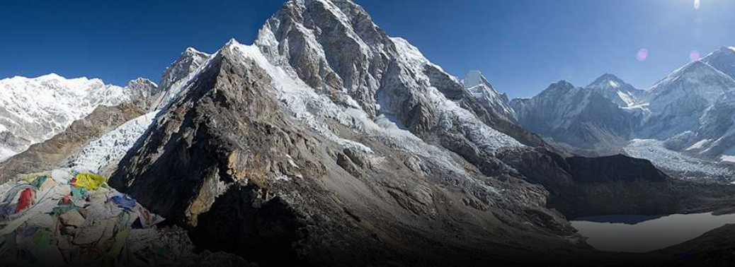
What are glaciers?
- A glacier is a large, perennial accumulation of crystalline ice, snow, rock, sediment, and often liquid water that originates on land and moves downslope under the influence of its own weight and gravity.
Status of Glaciers:
- Glaciers cover nearly 3% of Earth’s surface and 11% of Earth’s land area
- Source of three large river systems: Indus, Ganges, Brahmaputra
- Hindu Kush Himalayan Region is known as the “Water Towers of Asia“
- Himalayan mountains are referred to as the third pole
- India has over 16000 glaciers. E.g Siachen glacier in the Himalayan region.
Threats recognized:
- The majority of Himalayan glaciers are melting or retreating, which will severely affect flow in Himalayan River systems
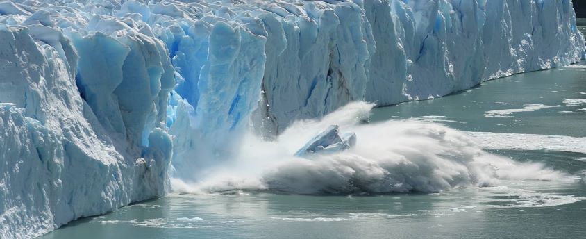
- Melting glaciers can cause disasters like Glacier Lake Outburst Floods (GLOF), glacier avalanches, etc.
- Melting of glaciers may lead to the shift of tree lines in the Himalayas and may also cause a change in the phonological behaviour of plants.
- Lack of data sharing on hydrological information with neighbouring countries
- Multiple ministries/departments/institutions with different mandates for dealing with Himalayan glaciers
Recommendations by the parliamentary panel:
- Set up a single nodal agency for bringing out synergies among various government departments/ministries involved in glaciological research and monitoring
- Establish regional cooperation for the seamless sharing of hydrological information/data on glacier movement/behaviour
- Create a multi-hazard alert and warning system
- Increase involvement of Himalayan states, planners, scientists, and academicians in devising suitable measures for glacier management
3 Million Indians Live in areas that can be Swept by Glacial Lake Floods
11, Feb 2023
Why in News?
- Three million Indians live in areas where a glacial lake outburst flood (GLOF) can happen at any time, the first global assessment of such areas has found. Together with two million Pakistanis, they form a third of the total number of people worldwide facing such a risk.
What is a GLOF?
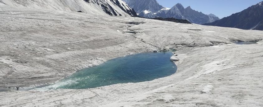
- A GLOF is a sudden release of water from a lake fed by glacier melt
- Threatens people’s lives, livelihoods and regional infrastructure.
- In the Hindu Kush Himalaya (HKH), GLOF events can be traced back to the failure of moraine-dammed glacial lakes
- The pressure on the dam, water seeping through the structure, fragmentation of the source glacier, landslides, etc., can trigger a GLOF.
- The frequency of GLOFs is expected to increase due to climate change.
What are the recent findings?
- The majority of the globally exposed population is located in the region of high mountain Asia and more than 50% in India, Pakistan, Peru and China.
- The population exposed to GLOFs increases with distance from a glacial lake.
- Rapid deglaciation over the last 20 years has led to the growth of many large glacial lakes.
- Increase in the population living in close proximity to glacial lakes between 2002 to 2022.
Situation in India:
- According to the ICIMOD, Himalayan glacial lakes increased by about 9% in number, and 14% in the area.
- The best-studied glacier is north India’s Chhota Shigri, which has lost three times its mass.
- The rapid onset of GLOFs means there is insufficient time to effectively warn downstream populations.
Importance of Himalayas and threat of degradation:
- The Himalayan range is a transnational mountain chain and is the chief driver of the Asian climate.
- It is a source for numerous Asian river systems and glaciers which are now under the threat of degradation and retreat due to global warming; these river systems provide water for billions of people.
- This legacy of humanity has now become highly contentious with territorial disputes between two nuclear powers — India and China.
- The ongoing low-level military confrontations between these two countries have led to demands for further infrastructural development on both sides, including all-weather roads, much to the peril of regional biodiversity and the livelihoods of the indigenous population.
- High seismic zones coincide with areas of high population concentration in the Himalayan region where landslides and glacial lake outburst floods are common.
- About 15% of the great earthquakes of the 20th century (with a magnitude of more than 8) occurred in the Himalayan region.
- The northeast Himalayan bend has experienced several large earthquakes of magnitude 7 and above in the last 100 years, more than the share from other parts of the Himalayas.
- In a recent article in Nature, Maharaj K. Pandit, a Himalayan ecologist, says in recent years, the Himalayas have seen the highest rate of deforestation and land use changes.
- He suggests that the upper Himalayas should be converted into a nature reserve by an international agreement. He also says the possibility of a Himalayan River Commission involving all the headwater and downstream countries needs to be explored.
What are the challenges such projects face?
- Following the break in the Raunthi glacier that triggered floods in the Rishiganga river in Uttarakhand on February 7, which washed away at least two hydroelectric power projects, environmental experts have attributed the glacial melt to global warming.
- Glacier retreat and permafrost thaw are projected to decrease the stability of mountain slopes and increase the number and area of glacier lakes.
- Climate change has driven erratic weather patterns like increased snowfall and rainfall.
- The thermal profile of ice, say experts, was increasing, which means that the temperature of ice that used to range from -6 to -20 degree C, was now -2 degree C, making it more susceptible to melting.
- It was these changing phenomena that made infrastructure projects in the Himalayan regions risky.
- Expert committees recommend that there should be no hydropower development beyond an elevation of 2,200 metre in the Himalayan region.
- Moreover, with increased instances of cloudbursts, and intense spells of rainfall and avalanches, residents of the region were also placed at increased risk of loss of lives and livelihood.
How can these conflicts be resolved?
- The challenges facing development in the Himalayan region are multi-faceted.
- The Uttarakhand government has said that it’s paying over ₹1,000 crore annually to purchase electricity and therefore, the more such projects are cancelled, the harder for them to meet their development obligations.
- Several environmentalists, residents of the region, say that the proposed projects being built by private companies allot only a limited percentage of their produced power for the State of Uttarakhand itself.
- Thus, the State, on its own, takes on massive environmental risk without being adequately compensated for it or its unique challenges accounted for.
- Several environmental activists say that the Centre has frequently changed its position and will continue to prioritise infrastructural development in the region, even if it comes at a heavy environmental cost.
CONTACT TRACING
20, Mar 2020

Why in News?
- Contact tracing is the process of identifying, assessing, and managing people who have been exposed to a disease to Prevent Transmission.
ICMR Guidelines:
- As per Indian Council of Medical Research guidelines, which are also directions that have sound public health sense behind them, people who may have been exposed to the virus are to be followed for 28 days from the date of the probable last exposure/arrival from affected countries.
- Any person who has had contact with the index patient under investigation/treatment for suspected, probable or confirmed case of SARS-COV-2, should be monitored for the appearance of symptoms.
Who is a Contact?
- Anyone who provided care for the suspect or confirmed case, including a health care worker (including those involved in cleaning, waste management, laboratory technicians, doctors) or family member, or anyone who had close physical contact; anyone who stayed at the same place (lived with, or visited) while the index patient was symptomatic.
- If symptoms appear within the first 28 days following the contact, the individual should be considered a ‘probable’ case and reported through the Integrated Diseases Surveillance Programme network to the National Centre for Disease Control.

Tracing Contacts:
- As soon as the single event (confirmed SARS-CoV-2) is detected, contact tracing must be aggressively implemented, and preferably to be completed within 48 hours.
- The contact tracing shall preferably be done by visiting the local residence of the contact(s) by a member of the health services team.
- On meeting the ‘contact person’, the visiting health worker should explain the purpose of contact tracing and collect data in a prescribed format.
- It is important to identify the social networks of the first patient and travel history during the 28 days after the onset of illness.
- Contacts should be traced and monitored for at least 28 days after the last exposure to the case patient for evidence of COVID-19 symptoms to emerge.
Symptomatic Contacts:
- Persons who have fever and cough and a history of contact with a confirmed case within the last 28 days should be referred for isolation for strict infection control.
- Samples must be collected and sent to the designated laboratory for testing, and appropriate medical management must begin.
- If contacts show symptoms, they may be isolated at a health care facility or at home until the results come in.
- Once confirmed as positive for SARS-CoV-2, they must be shifted to a proper health facility.
INCOIS – WARNING SYSTEMS
04, Mar 2020

Why in News?
- The Indian National Centre for Ocean Information Services (INCOIS), Hyderabad has launched Small Vessel Advisory and Forecast Services System (SVAS), Swell Surge Forecast System and Algal Bloom Information Service (ABIS) recently.
Small Vessel Advisory and Forecast Services System:
- Small Vessel Advisory and Forecast Services System (SVAS) has been launched to improve operations on the numerous small marine vessels, particularly fishing vessels that ply the coastal waters of India.
- It is an innovative impact-based advisory and forecast service system for small vessels operating in Indian coastal waters.
- The SVA system warns users about potential zones where vessel overturning can take place, ten days in advance.
- The advisories are valid for small vessels of beam width up to 7 m.
- This limit covers the entire range of beam widths of the fishing vessels used in all the 9 coastal states and union territories of India.
- The warning system is based on the ‘Boat Safety Index’ (BSI) derived from wave model forecast outputs such as significant wave height, wave steepness, directional spread and the rapid development of wind at sea which is boat-specific.
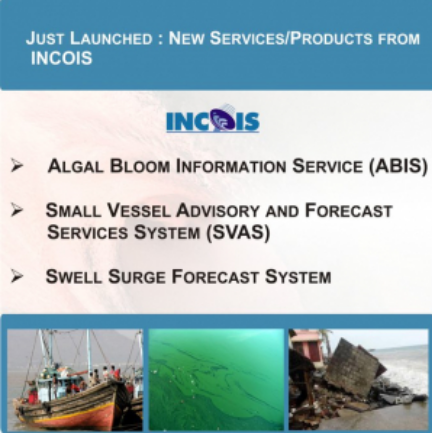
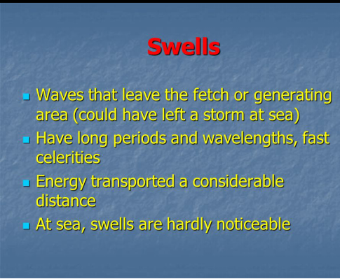
Swell Surge Forecast System:
- The Swell Surge Forecast System has been launched to provide swell surge forewarnings for the coastal population of India’s vast shoreline, which experiences damages caused by the swell waves.
- They are flash-flood events that take place without any noticeable advance change in local winds or any other apparent signature in the coastal environment.
- Hence the local population remains totally unaware of these flooding events until they actually occur.
- These events have attracted attention especially after the 2004 Tsunami in the Indian Ocean, since most people mistake Kallakkadal to be Tsunamis.
- Tsunami and Kallakkadal/Swell surge are two different types of waves with entirely separate causes or mechanisms.
What are Swell Surges?
- Kallakkadal is a colloquial term used by Kerala fishermen to refer to the freaky flooding episodes and in 2012 UNESCO formally accepted this term for scientific use.
- During Kallakkadal events, the sea surges into the land and inundates vast areas.
- Such events are intermittent throughout the year.
- Kallakkadal or Swell surge occurs along the Indian coast, particularly the west coast.
- Kallakkadal are caused by meteorological conditions in the Southern Ocean, south of 30°S.
- A study by INCOIS scientists has revealed that specific meteorological conditions in the Southern Indian Ocean support the generation of long period swells.
- These swells once generated, travel northward and reach the Indian coasts in 3-5 days’ time, creating havoc in the coastal areas.
- The system will now predict Kallakkadal and warnings will be given to concerned authorities at least 2-3 days in advance, which will help the local authorities for contingency plans and to reduce damage.
Algal Bloom Information Service:
- The Algal Bloom Information Service (ABIS) has been launched to provide timely information on harmful algal blooms, which are detrimental to coastal fisheries and also tend to induce respiratory problems within the coastal population from time to time.
- The increasing frequency of algal blooms is a major concern due to its ill effects on fishery, marine life and water quality.
- INCOIS has developed a service for “Detection and Monitoring of Bloom in the Indian Seas”.
- The target users are fishermen, marine fishery resource managers, researchers, ecologists and environmentalists.
- The service also complements INCOIS’ marine fishing advisories i.e. Potential Fishing Zone advisories.
- INCOIS-ABIS will provide near-real time information on spatio-temporal occurrence and spread of phytoplankton blooms over the North Indian Ocean.
- Accordingly, relevant data retrieved from satellites i.e. Sea Surface Temperature, chlorophyll-a, Algal Bloom Index – chlorophyll, rolling chlorophyll anomaly, rolling sea surface temperature anomaly, phytoplankton class/species, phytoplankton size class and a composite image delineating bloom and non-bloom regions will be disseminated daily through ABIS.
- In addition, four regions have been identified as bloom hotspots:
- North Eastern Arabian Sea
- coastal waters off Kerala
- Gulf of Mannar, Tamil Nadu
- coastal waters of Gopalpur, Odisha
Indian National Centre for Ocean Information Services:
- Indian National Centre for Ocean Information Services (INCOIS) provides a number of free services for users in the marine realm.
- The institute is an autonomous organisation under the Ministry of Earth Sciences.
- INCOIS prioritises requests for specific services from its diverse user community that ranges right from fishermen to offshore oil exploration industries.
WATER CRISIS IN HIMALAYAN REGION LOOMS LARGE
03, Mar 2020
Why in News?
- Recently, several towns were surveyed in the Himalayan region of Bangladesh, Nepal, India and Pakistan to understand the challenges of the water crisis in urban areas of these regions.
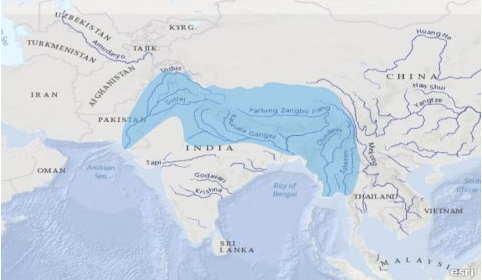
About Hindu Kush Himalayan Region:
- The HKH region spans Afghanistan, Bangladesh, Bhutan, China, India, Kyrgyzstan, Mongolia, Myanmar, Nepal, Pakistan, Tajikistan, and Uzbekistan.
- It traverses about 5 million square kilometres and hosts a large and culturally diverse population.
- It is considered the Third Pole (after the North and South Poles), and has significant implications for climate.
- It contains vast cryospheric zones and is also the world’s largest store of snow and ice outside the polar region.
- A recent report by the Intergovernmental Panel on Climate Change has highlighted the threat to the HKH region from global warming.
- Floods would become more frequent and severe in the mountainous and downstream areas of the Indus, Ganges and Brahmaputra river basins, because of an increase in extreme precipitation events.
- Also, the severity of floods is expected to more than double towards the end of the century.
What are the Key Highlights of the Report?
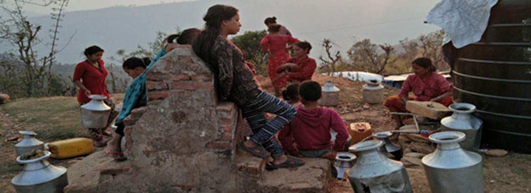
- Eight towns in the Himalayan region of Bangladesh, Nepal, India and Pakistan were nearly 20%-70% deficient in their water supply.
- The places surveyed are extremely dependent on springs (ranging between 50% and 100%) for their water, and three-fourths were in urban areas.
- Rural areas have typically garnered much of the attention in terms of development and issues surrounding urban environments have been side lined.
- Factors responsible are as follows:
- Unplanned urbanisation
- Climate change
- Across the region, the encroachment and degradation of natural water bodies (springs, ponds, lakes, canals, and rivers) and the growing disappearance of traditional water systems (stone spouts, wells, and local water tanks) are evident.
- Although only 3% of the total Hindu Kush Himalayan population lives in larger cities and 8% in smaller towns, projections show that over 50% of the population will be living in cities by 2050, placing stress on water availability.
- Under current trends, the demand-supply gap may double by 2050.
Water Crisis in India:
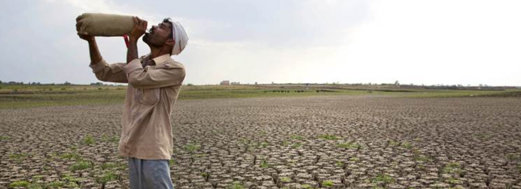
- India tops the list of countries with the most number of people living with water scarcity.
- As many as one billion people in India live in areas with physical water scarcity, of which 600 million are in areas of high to extreme water stress.
- Approximately 330 million people from 302 districts were affected by droughts in 2016.
- Over 21% of the country’s diseases are water related. In 2015, India lost over 1 lakh children under the age of five to diarrheal diseases.
- As per a report by NITI Aayog, Bengaluru will soon be among one of the 11 cities in the world to run out of ground water.
- The report also states that the ‘Day Zero’will hit Bengaluru and 20 other major cities (including Delhi) in India by the year 2020 affecting an estimated 100 million people.
What is Day Zero?
- Day Zero is a situation when taps in a region start running dry. It is a situation when there will be no water in the taps and the use of water will become restricted for vital services only.
- Considering the present situation of water crisis in several cities of India, they are being termed as soon to be India’s Cape Towns.
- The city of South Africa ‘Cape Town’,in 2018, launched a countdown to the day when tap water would be cut-off to millions of residents as a result of a three year drought.
- Brazil’s Sao Paulo faced its own Day Zero in 2015. The city turned off its water supply for 12 hours a day forcing many businesses and industries to shut down.
- In 2008, Barcelona in Spain had to import tankers full of fresh water from France.
Way Forward:
- Communities were coping through short-term strategies such as groundwater extraction, which is proving to be unsustainable.
- A holistic water management approach that includes spring shed management and planned adaptation is therefore paramount.
WHO NOT TO DECLARE SARS-COV-2 A PANDEMIC
29, Feb 2020

Why in News?
- WHO Director-General Tedros Adhanom Ghebreyesus made it abundantly clear that WHO will not declare COVID-19 a pandemic at this moment.

Highlights:
- A pandemic is defined as the worldwide spread of a new disease. The last pandemic reported was the 2009 H1N1 flu pandemic, which killed hundreds of thousands globally.
- According to 2017 pandemic influenza risk management guidelines, the WHO uses pandemic influenza phases, interpandemic, alert, pandemic and transition, to reflect its risk assessment of the global situation regarding each influenza virus with pandemic potential infecting humans.
- Fourteen countries have managed to contain the spread of the virus and no new case has been reported for more than a week. And nine countries, including India, Nepal and Sri Lanka, have not reported any additional cases in the last two weeks.
- This highlights that the virus can be stopped in its track if countries take appropriate and timely actions. Except Antarctica, novel coronavirus cases have been reported from all continents.
- In the past week, 20 countries have confirmed their first coronavirus cases. South Korea has the most number of confirmed novel coronavirus infections, 1,766 (and 13 deaths) outside mainland China. Italy (528), Iran (245) and Japan (189) are the other countries with most number of cases.
Measures to Stop Spread:
- The priority should be to detect cases early and isolate people who test positive for the virus. Once a case is detected, the focus should be to trace the contacts and treat them if already infected.
- Though the average incubation period is five-seven days, a few have shown up symptoms at the end of 24 days.
- Efforts should also be focussed on preventing outbreaks in hospitals and spread in the community.
- One way to stop the spread in the community is to avoid mass gathering in enclosed spaces.
Coronavirus:

- This is a new coronavirus that has been identified for the first time in the city of Wuhan, the capital of the Hubei Province in mainland China.
- It was identified after people developed pneumonia without an evident cause and where current vaccines and treatment methods were not effective.
- There have been around 40000 people infected with the virus in China. There have also been over 1000 fatalities there, exceeding those from SARS.
- A handful of cases have also been reported outside China, in Australia, Thailand, France, the US and a few other countries as well. India reported its first case towards the end of January 2020.
- There is not much known about the new coronavirus, which has been designated 2019-nCoV.
- It is considered a novel virus outbreak because the virus is novel (new – not seen earlier)
ULSOOR LAKE
28, Feb 2020

Context:
- Recently, the National Green Tribunal (NGT) has directed the constitution of a joint committee to take samples of water from Bengaluru’s Ulsoor lake and its neighbouring areas.
About the Components of Water Analysis:
- Biochemical Oxygen Demand (BOD)
- It is the amount of dissolved oxygen used by microorganisms in the biological process of metabolizing organic matter in water.
- The more organic matter there is in sewage and polluted bodies of water, the greater the BOD; and the greater the BOD, the lower the amount of dissolved oxygen available for higher animals such as fishes.
- It will be greater when more organic matter
- The main reasons for treating wastewater prior to its discharge into a water resource is to lower its BOD and thereby lessen its demand from the streams, lakes, rivers, or estuaries into which it is released.
- Chemical Oxygen Demand (COD): It is a method of estimating how much oxygen would be depleted from a body of receiving water as a result of bacterial action.
- The pathogen present in the water is determined with indirect evidence by testing for an “indicator” organism such as coliform bacteria.
- Coliform Bacteria: It is bacteria that are always present in the digestive tracts of animals, including humans, and are found in their wastes. They are also found in plant and soil material.
- Presence of Heavy metals are known to induce cardiovascular diseases, developmental abnormalities, neurologic and neurobehavioral disorders,
- diabetes, hearing loss, hematologic and immunologic disorders.
About Ulsoor Lake:
- It is part of a network of hundreds of reservoirs in Bangalore built by the Gowda Kings to provide the city with a sustainable potable water supply. The lakes were connected by stormwater channels known as Nalahs.
- It is one of the largest lakes remaining of this network, suffering from environmental challenges including poor water quality, degraded landscape and ecology, poor public realm, as well as the abundance of surrounding vehicular traffic.
The National Green Tribunal:
- It has been established on 18.10.2010 under the National Green Tribunal Act 2010 for effective and expeditious disposal of cases relating to environmental protection and conservation of forests and other natural resources including enforcement of any legal right relating to environment and giving relief and compensation for damages to persons and property and for matters connected therewith or incidental thereto.
- It is a specialized body equipped with the necessary expertise to handle environmental disputes involving multi-disciplinary issues. The Tribunal shall not be bound by the procedure laid down under the Code of Civil Procedure, 1908, but shall be guided by principles of natural justice.
- The Tribunal’s dedicated jurisdiction in environmental matters shall provide speedy environmental justice and help reduce the burden of litigation in the higher courts.
- The Tribunal is mandated to make and endeavour for disposal of applications or appeals finally within 6 months of filing of the same.
- Initially, the NGT is proposed to be set up at five places of sittings and will follow circuit procedure for making itself more accessible. New Delhi is the Principal Place of Sitting of the Tribunal and Bhopal, Pune, Kolkata and Chennai shall be the other four place of sitting of the Tribunal.
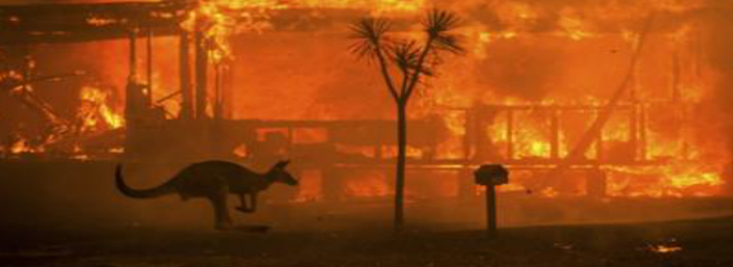
DEVASTATING AUSTRALIAN BUSHFIRE
18, Jan 2020
Why in News?
- Australia is witnessing its most devastating bushfire season in at least 20 years.
About Bushfires:
- Forest fires, or bushfires, routinely occur across the world in hot and dry seasons.
- Dry leaves, grass, shrubs, deadwood etc are easily combustible. Ignition happens naturally, from lightning strikes for example, or accidentally, from sources such as cigarette stubs.
- Suitable speed and direction of wind helps spread a forest fire faster. It usually comes to an end due to rain or because there is no further contiguous vegetation to spread to.
- Sometimes, fires are ignited on purpose, for example, in 2019; the fires in the Amazon forests in Brazil had become controversial because they were largely seen to have been a result of deliberate burning by farmers and large agro-industry players keen on getting more land.During the summer months, fires are common in the forests of India as well.
- This Australian summer, the spread and intensity of forest fires are something never seen before. The fire has impacted more than 10.3 million hectares of forest land so far, an area the size of South Korea. People and millions of wild animals have died.
Why common in Australia?
- Australia, where the summer starts around October, is known to be the most fire-prone of all continents. This is mainly because Australia is also the driest inhabited continent.
- Almost 70% of its area comprises arid or semi-arid land, with average annual rainfall less than 350 mm.
- Australia has about 134 million hectares of forest land. Bushfires are pretty common every year in summer.
- Australian government data show that about 55 million hectares of forest land, i.e more than 40% of the entire forests, had been affected by at least one such fire in the period between 2011 and 2016.
Reasons for Bushfires:
- Prolonged Drought
1.The three years between 2017 and 2019 were the driest 36-month period ever in the New South Wales (a state of Australia).
2.2019 happened to be the warmest and driest year for the country since 1900.
3.Daytime temperatures were, on average, 2°C higher than normal, while the average rainfall for the country was 40% below normal.
4.Heat and dryness are the key preconditions for the ignition and spread of Forest Fires.
- Positive Indian Ocean Dipole (IOD)
1.In 2019, the problem has been compounded by the presence of one of the strongest-ever positive Indian Ocean Dipole (IOD) events. Positive IOD events are often associated with a more severe fire season for South-east Australia.
- Rare stratospheric warming over Antarctica
1.Temperatures were 30°C to 40°C higher than normal in the region 10 to 50 km from Earth’s surface — another extraordinary weather event that could have contributed to the unusual heat and dryness in Australia.
Is there any link with Climate Change?
- Experts say climate change has worsened the scope and impact of natural disasters such as fires and floods.
- Weather conditions are growing more extreme, and for years, the fires have been starting earlier in the season and spreading with Greater Intensity.
What are the impacts of IOD on India and Australia?
- The IOD refers to the difference in sea-surface temperatures in the eastern and western Indian Ocean.
- This either aids or cuts off moisture supply to Australia, depending on whether the western Indian Ocean is cooler or the eastern.
- This year, the eastern Indian Ocean has been unusually cold, and that contributed to the rainfall deficiency over Australia.
- The 2019 June-September monsoon in India started its withdrawal on October 9, against the normal date of September 1, making it the most delayed in recorded history.
- It was also the strongest in recent years with a surplus of 10% in 2019 — both attributed in part due to the positive phase of the Indian Ocean Dipole (IOD).
- During a positive IOD phase, the west Indian Ocean warms up anomalously (creating lower pressure and wet climes) relative to the east (higher pressure and a dry phase, towards the Australian side).
- A positive IOD that has persisted longer than usual is thought to have contributed to a delay in transition of the monsoon trough from the Northern Hemisphere to the Southern Hemisphere and onset of the Australian monsoon.
FOREST FIRES
04, Jan 2020
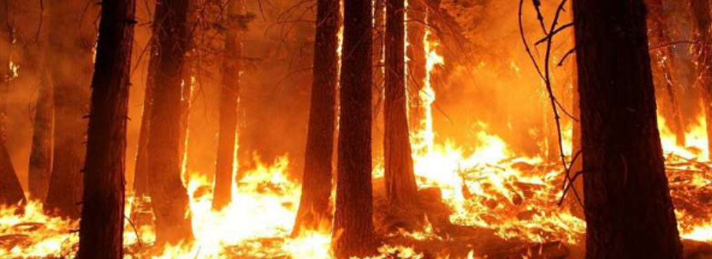
Why in News?
- About 21.40% of forest cover in India is prone to fires, with forests in the north-eastern region and central India being the most vulnerable, the 2019 report by the Forest Survey of India (FSI) has said.
Findings:
- The finding has emerged from a study carried out by the FSI along forest fire points identified across the country from 2004 to 2017.
- The forest fire points (FFP) identified during the 13 years add up to 2,77,758. They were analysed using a moderate resolution imaging spectroradiometer (MODIS) by overlaying the points coverage over the grid coverage of 5 km x 5 km.
Highlights:
- Extremely fire prone areas account for 3.89% of total forest cover, very highly fire prone areas account for 6.01% and highly fire prone areas for 11.50%. Together, the three categories come to 21.40 % of forest cover.
- The total number of alerts issued for each state based on MODIS data from November 2018 to June 2019 were 29,547 and interestingly, Mizoram, a small State, recorded the highest number of fire alerts (2,795).
- The seven States of the north-eastern region accounted for 10,210 fire alerts, which make up about one-third of alerts in the country.
- While the overall green cover has increased in the country, the forest cover in the north-east — particularly in Mizoram, Arunachal Pradesh and Nagaland — has decreased, the fires could be one of the causes.
- Central Indian States also recorded a high number of forest fire alerts, with Madhya Pradesh accounting for 2,723 alerts; Maharashtra 2,516; Odisha 2,213 and Chattisgarh 1,008 alerts between November 2018 to June 2019.
- The reasons for fires here are manmade, particularly in cases where people visit forests and leave burning bidis, cigarette stubs or other inflammable materials. In cases of natural reasons, the scientist pointed to thunderstorms as the most likely cause.
- The FSI report states that uncontrolled forest fires can lead to significant loss of cover. “Studies suggest that climate change influences forest fire frequency and intensity, resulting in forests becoming increasingly inflammable
Reasons for Forest fires in North East:
- One of the major reasons for forest fires in the north-east is slash-and-burn cultivation, commonly called jhoom or jhum cultivation. The fires happen between the months of January and March. The north-east has tropical evergreen forests and, unlike the dry deciduous forests of central India, these are not likely to catch fire easily.
DROUGHT ACTION PLAN
24, Sep 2019
Context:
- The National Rainfed Area Authority (NRAA) is working on developing a comprehensive drought-proofing action plan for 24 districts in Rajasthan, Andhra Pradesh and Karnataka this year.
Background:
- The NRAA will develop similar action plans for other districts in a list of 151, including in Maharashtra, identified as drought-prone according to a study by Indian Council of Agricultural Research (ICAR), based on parameters set by the Intergovernmental Panel on Climate Change.
Role of Government:
- The primary responsibility of managing drought (or any other natural disaster) is that of the State Governments. The role of Central Government is to supplement the efforts of the State Government in effective management of disasters and provide additional resources (food grains / financial assistance etc.) to combat the situation.
What is Drought:
- Drought connotes a situation of water shortage for human, cattle and agriculture primarily on account of, though not limited to, significant shortfall in rainfall.
National Rainfed Area Authority:
- The Union Government has constituted a National Rainfed Area Authority on 3 November, 2006 to give focused attention to the problems of rainfed areas of the country.
Drought Management Plan:
- Drought Management Plan (DMP) is designed to help reduce the time taken in mobilizing resources for an effective response and enable a harmonious relationship among stakeholders.
- The goal of DMP is to facilitate overall management of the drought situation in a structured and planned manner with the most efficient and optimum utilisation of time, effort and resources so that adverse impact on the community is minimised.
- DMP helps in delineating roles and responsibilities of different Ministries/Departments of the Government of India involved in drought management for mitigation, preparedness and for relief measures in managing the drought.
- DMP ensures better preparation and timely communication among stakeholders, which is critical in managing a drought.
Disaster Management (DM) Act, 2005:
- Section 11 of the DM Act, 2005 mandates that there shall be a National Disaster Management Plan (NDMP) for the whole of India.
- While the national plan will pertain to the disaster management for the whole of the country, the hazard specific nodal ministries and departments notified by the Government of India will prepare detailed DM plans specific to the disaster assigned.
Sendai Framework for Disaster Risk Reduction (DRR):
- The Sendai Framework for Disaster Risk Reduction 2015-2030 is a non-binding agreement, which the signatory nations, including India, will attempt to comply with on a voluntary basis.
- The four priorities for action under the SendaiFramework are:
- Understanding disaster risk
- Strengthening disaster risk governance to manage disaster risk
- Investing in disaster risk reduction for resilience
- Enhancing disaster preparedness for effective response and to “Build Back Better” in recovery, rehabilitation and Reconstruction.
AKADEMIK LOMONOSOV- RUSSIA’S FLOATING NUCLEAR POWER PLANT
18, Sep 2019
Why in News?
- Recently Russian-built floating nuclear power plant completed its 5,000-km journey along the Northern Sea Route, causing excitement in the energy sector, but sparking fears among environmentalists over the safety of the Arctic region. The ‘Akademik Lomonosov’, is the first such plant to be built in the world.
About Akademik Lomonosov:
- The Akademik Lomonosov is a first-of-its-kind floating nuclear power station built in St Petersburg, the Russian port city on the Gulf of Finland. Three tugboats pulled it from the northern port of Murmansk for 5,000 kilometres to Chukotka, in Russia’s far east.
- Named after the 18th-century Russian scientist Mikhail Lomonosov, the 21,000-tonne floating plant is 144 m long and 30 m wide, and contains two nuclear reactors of 35 MW each. It is a small plant compared to conventional land-based nuclear projects.
- Run by the state-owned nuclear energy corporation Rosatom, the Akademik Lomonosov is expected to have a working life of 40 years which can be expanded to 50 years.
- According to Rosatom, the Akademik Lomonosov is part of a larger plan to provide energy to remote regions in Russia and around the world.
- It said that floating nuclear units could be particularly beneficial to island nations and can be used to power desalination plants for countries with a shortage of fresh water.
- The company has also said that, because many remote areas rely on coal-burning plants, the portable nuclear plants will help to reduce emissions of carbon dioxide, a greenhouse gas that contributes to climate change.
Concerns of Disaster:
- The environmental group Greenpeace has called the plan “Chernobyl on Ice”, referring to the1986 nuclear power plant meltdown, which released large levels of radiation into the atmosphere, forced thousands to flee their homes and sparked long-term fears of health and environmental repercussions.
- Activists fear that any accident aboard the plant could cause great damage to the fragile Arctic region. A recent nuclear accident in Russia after which there was a brief spike in radiation levels has added to the fears.
- The radiation fallout from the Fukushima nuclear disaster in Japan is also cited as a reason to not rush into such projects.
- The launch is part of a wider ambition of Russian President Vladimir Putin to develop the Northern Arctic region. That desire has become more realistic in recent years with global warming and melting ice caps making some areas more accessible.
- Critics have pointed to past incidents involving nuclear sea vessels, including the sinking of the gargantuan Kursk Submarine in 2000 and the leaking of radiation by a Russian icebreaker off the coast of Siberia in 2011.
Conclusion:
- The incident-ridden history of Russian nuclear icebreakers and submarines shows the need for strict, independent oversight with international peer review.
- This must start now, before the reactors are loaded, and span the plant’s entire risky operation – including transport, decommissioning and waste management.
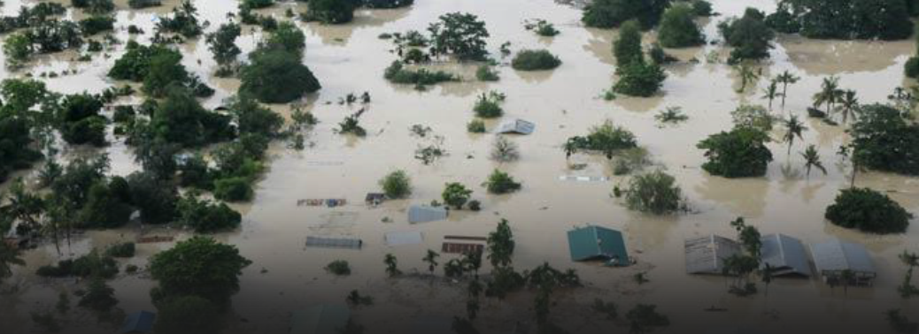
FLOODS IN MAHARASHTRA
11, Aug 2019
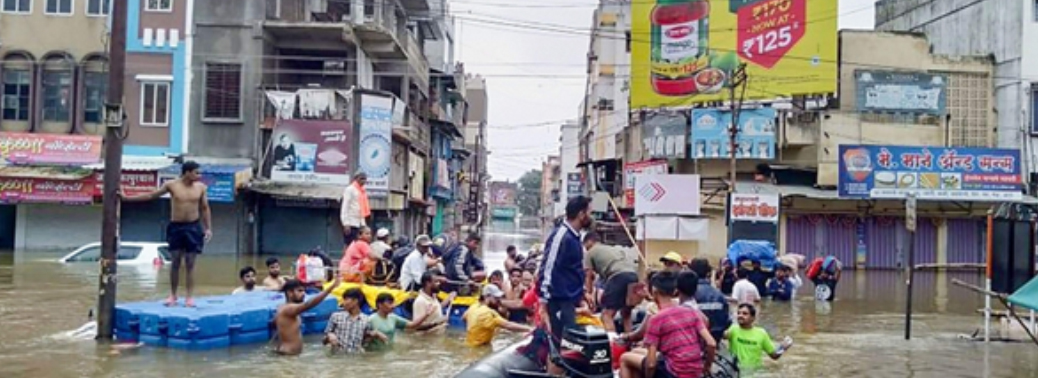
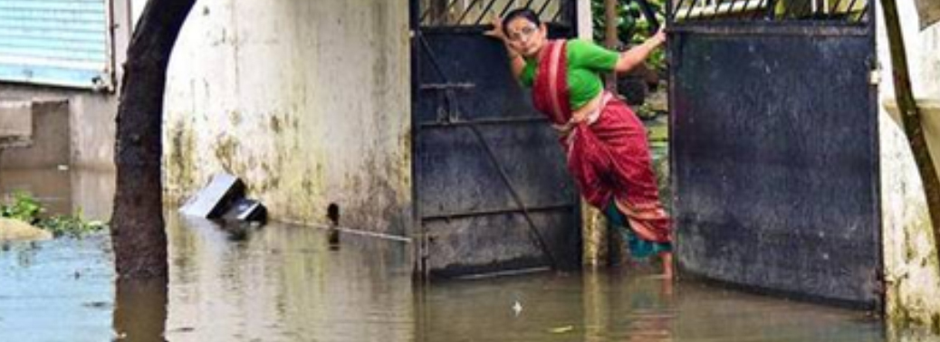
- Context: Between August 1 and 10, rains battered south-western Maharashtra, and rising water levels in local rivers breached the banks. Areas in Pune, Kolhapur, Satara and Sangli saw large areas flooded, houses and roads damaged and lakhs of people displaced.
Background:
- Similar situation happened in the year 2005.
- Krishna river, the lifeline of South-Western Maharashtra, has wreaked havoc in the districts it flows through.
- Large tracts of land in Satara, Sangli, Kolhapur and Pune continue to remain under water.
Dams on Krishna:
- Dams dot the course of Krishna and her tributaries across Maharashtra, Karnataka, Andhra Pradesh and Telangana.
- These dams are the lifeline of western Maharashtra, and are a major supporting factor for the area’s sugarcane-based economy.
- Almatti, a major dam on Krishna that is located in Karnataka, close to the Maharashtra border, controls the flow of water into the neighbouring state. The release of water into the river and its tributaries are kept in check to conserve water.
The Effect of the Flood:
- As water levels rose after the heavy rainfall, almost all the dams started discharging water.
- What went wrong in the process was perhaps the lack of coordination between the Maharashtra and Karnataka governments to enable simultaneous discharge from Almatti dam.
- Almatti Dam
- The position of Almatti dam is unique, as this is the first dam on Krishna river after it leaves Maharashtra.
- The amount released from the dam is important to prevent any flooding upstream of Krishna, which is Maharashtra.
- In this case, the discharge from the dam was low, though the Maharashtra side had seen the river swelling due to heavy rain and opening of all dam gates.
- As the amount of water released from Almatti was kept low, the water of Krishna kept coming back, which led to the flooding.
- Chief Minister of Maharashtra intervention led to the increased discharge from Almatti. As of now, the discharge from this dam is over 5.3 lakh cusec as against the inflow of 6 lakh cusec.
What led to the flooding?
Concern by advocacy group SANDRP (South Asia Network of Rivers Dams and People)
- Why authorities didn’t release water from the dams in a controlled manner earlier.
- Controlled release of water would have allowed the dams enough reservoir space to withstand the heavy rain.
- It would have been a more effective measure compared to the kneejerk response of opening the dam gates to release large quantity of water.
Poor Dam Management:
- Water levels in the dam, as reported by the water resources department, had shown a steady rise since the beginning of monsoon.While the monsoon was sluggish in June, it picked up pace in July, and water levels in the dams rose.On July 10, the water level of all 726 dams in Pune Division stood at 23.25 per cent as against 34.63 per cent of last year.
- But by August 3, as the state witnessed intense spells of rain, these dams reported 69.9 per cent water storage.
- However, what might have brought about the urgency in discharge is the fact that the reluctance of the irrigation department to carry out release from the dams left little or no space in the reservoirs once the upstream areas started receiving torrential rains.
- With barely any other option, the dam gates were opened suddenly, and the catchment areas were flooded.
How Dam Management Works?
- Dam management is an inter-departmental job, which involves close coordination between the departments of revenue, water resources and agriculture, as well as the weather forecaster.The release of water is managed by taking into account the projected water usage for human consumption, agriculture and industries.
- In case of a weak monsoon, less water is released to tide over the non-monsoon months.
- One of the reasons why dam levels were allowed to reach up to 70 per cent might be because of the uncertainty of monsoon rains.
- In June and July, Pune Division reported cumulative rainfall of 522.1 mm, which was 105.1 per cent of the long-time average of 496.6 mm.
- But by August 10, the division recorded 309.1 mm as against the 69.9 mm normal, a startling 442.2 per cent more.
No Lessons from the past?
- In fact, Maharashtra had set up a committee after the Aug 2005 floods, but the report of that committee remains a state secret till date!
- We need to understand and acknowledge that capacity of our catchment areas to hold, to absorb, store the rainwater and recharge the groundwater in a decentralised manner is reducing, thanks to our indiscriminate and mindless development pursuits.
What needs to be done?
- We need to really work to improve the capacity of the catchment to hold, store and absorb the rainwater and recharge the groundwater.This includes increasing the capacity of our soils to hold and store moisture and having sufficient local water harvesting systems, wetlands, forests and other groundwater recharging mechanisms.
- That would help reduce the flood peaks and also drought frequency and intensity.
Conclusion:
- However, immediately, we need to ensure that the water stored in the dams is judiciously released to make way for possibly high rainfall incidents in coming weeks.
- The mismanagement of all the dams need to be put out in public domain and accountability fixed when the rule curves are violated.
MAHARASHTRA TO SET UP TASK FORCE ON CLIMATE CHANGE
09, Aug 2019
- Context: In the wake an unprecedented flood like situation and record rainfall this season, the State government will constitute a task force of local and global experts to study impact of climate change on Mumbai.
What the Task Force Will Do?
- The task force will study measures taken against flood and unplanned reclamation in cities such as Venice, Geneva and London, and coordinate with the European Climate Change Programme of the European Union to prepare a blueprint.
- The task force will be set up by the Environment Department in coordination with Mumbai First, a not-for-profit policy influencing think tank.
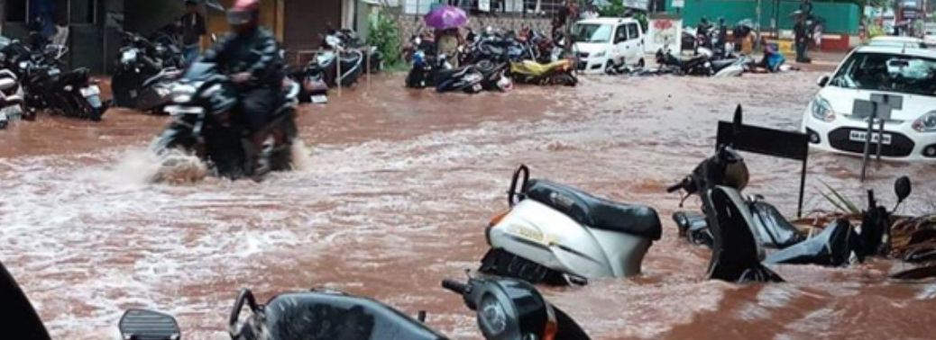
What is Urban Flooding?
- Flooding is an accumulation of water in an area either by direct rainfall irresistible to the volume of drainage systems or a spill of huge amount of water from water bodies beyond normal limits.
- It could be localized, impacting a small area or could be vast or massive, impacting very large area. Urban flooding is caused by heavy rainfall overwhelming drainage capacity.
- Urban flooding is one of the types of flood.
- Urban flooding is the inundation of property in more densely populated areas caused by rainfall and sometimes triggered by events such as flash flooding or snowmelt.
Impacts of Flood:
- It already has large economic and social impacts.
- These are very likely to increase if no changes are made to the unplanned development of buildings and infrastructure and poor management of urban drainage.
- Urban floods are a great disturbance of daily life in the city.
- Urban flooding is a condition that has repetitive impacts on communities. Urban areas are densely populated and people living in vulnerable areas suffer due to flooding. It is not only the event of flooding but the secondary effect of exposure to infection also has its toll in terms of human suffering.
- Damage to vital infrastructure, loss of life and property.
- Disruption in transport and power and incidence of epidemics, loss of livelihood.
- Urban flooding cause localized incidents to major incidents, resulting in cities being inundated from hours to several days.
- Deterioration of water quality and risk of epidemics.
- Temporary relocation of people, damage to civic amenities.
Natural causes:
- Meteorological Phenomenon: Cyclone like Ockhi, Roanu, Vardah making landfalls in coastal areas induce heavy rainfall finally leading to flooding.
- Excessive rainfall in some cases.
- Change in course of river: Eg: Kosi in Bihar
Man-Made Causes are as Follows:
- More migration causes reduced availability of land and it finally leads to more encroachment of water bodies.
- Disposal of waste results in waste clogging the natural channels and stormwater drains.
- Encroachment:
- More migration -reduced availability of land – higher economic value of land – more encroachment of water bodies – reduced economical services from water bodies.
- Eg-Charkop Lake in Maharashtra, Ousteri Lake in Puducherry, Deeporbeel in Guwahati are well known examples of encroachment.
- Illegal mining activities and Illegal construction have an extremely damaging impact on the water body.
- Sudden release or failure to release water from dams can also have a severe impact.
- The badly planned construction of bridges, roads, railway tracts causes drainage congestion.
- Unplanned release of water from dams and unplanned tourism activities
- Absence of drainage and stormwater network in many places.
- Rapid urbanization causes permeable soil surfaces being replaced by impermeable concrete floors leads to urban flooding.
- Increase in urban rainfall extremes and temperature.
Action That Needs To Be Taken:
- Create flood plains and overflow areas for rivers and separating rainwater from the sewer system.
- Install water infiltration and attenuation systems, Sustainable drainage: permeable pavement, sidewalks, and gardens.
- Strong laws should be in place to protect urban lakes the water bodies.
- The catchment and feeder channels need to be protected.
- There is a need to set up an umbrella authority to protect and conserve the water bodies.
- Funds should be provided for water supply to only those cities that have brought their own water sources under protection.
Conclusion:
- Floods in India are an outcome of both natural and man-made changes.
- However, the latter has been more responsible for floods in the current age of Anthropocene.
- Thus, a comprehensive urban planning which reconciles both environment and economic needs is required.
NATURAL SIGNS OF FLOODS FOR URBAN AREAS
09, Aug 2019
Why in News?
- A study in the Journal of the British Academy has found that indigenous knowledge on how nature warns of flooding is relevant in urban areas as well.
Highlights:
- Climate change and population growth put millions of people at risk of increasingly unpredictable weather patterns.
- More than 3 million urban dwellers could be at risk of flooding from extreme rainfall by 2050 as climate change brings more unpredictable weather hazards, the study said.
- According to a 2018 report for the C40 cities, extreme heat and power blackouts, alongside food and water shortages, are other threats if climate changing emissions are not curbed.
- The study interviewed 1,050 people in 21 rural and urban communities in Ghana, including the capital city Accra and the main city of Tamale in its Northern Region.
Indigenous Knowledge:
- Indigenous knowledge about how to spot flood risks ahead of time could save lives in cities. Indigenous people in Tanzania, Zimbabwe, Myanmar and Ethiopia, for example, use their knowledge to observe and mitigate impacts of extreme climate events such as flooding and droughts.
- Indigenous knowledge can be used as an additional layer to scientific research in designing early warning systems for floods.
Signs of Nature:
- Understanding changes in natural indicators, such as plants, birds and temperatures, could be used to alert urban residents to extreme weather.
- Knowledge transfers that can be made between rural and peri-urban spaces could save lives and livelihoods around the world.
- Researchers documented natural indicators used by indigenous communities to predict floods, droughts and temperature changes.
- The indicators include:
- Links between rainfall patterns and ant behaviour
- Appearances by certain birds
- Flowering of baobab trees
- Observations of heat intensity
- Promoting tree-planting in urban areas could offer further opportunities to apply indigenous knowledge on flora in cities.
NGT Raps states for not curbing pollution in Ganga
01, Jun 2019

Why in news
- The National Green Tribunal (NGT) has imposed a penalty of Rs. 25 lakh each on the States of Bihar, Jharkhand and West Bengal for not taking adequate steps to curb pollution in the river Ganga.
Details:
- A Bench headed by NGT Chairperson observed that while in Bihar there was no progress in terms of completion of sewage treatment infrastructure projects, in West Bengal only three out of the 22 projects had been completed. “The States of West Bengal, Bihar and Jharkhand are not represented in spite of orders of this Tribunal by which we recorded strong disapproval to such attitude of the said States. Such insensitivity in a serious matter is a matter of concern,” the Bench observed.
- NGT directed the [three] States to deposit Rs. 25 lakh each by way of interim compensation for continued damage to Ganga and inaction of the said States even in responding to this Tribunal. The States were directed to deposit the penalty within a month with the Central Pollution Control Board, and the amount “may be spent on restoration of the environment.” Noting that the discharge of effluents is an offence, the green panel directed the Uttar Pradesh government to prohibit industrial activity that resulted in pollution.
What is National Green Tribunal (NGT)?
- It is a specialised body set up under the National Green Tribunal Act (2010) for effective and expeditious disposal of cases relating to environmental protection and conservation of forests and other natural resources. With the establishment of the NGT, India became the third country in the world to set up a specialised environmental tribunal, only after Australia and New Zealand, and the first developing country to do so.
- NGT is mandated to make disposal of applications or appeals finally within 6 months of filing of the same.
- The NGT has five places of sittings, New Delhi is the Principal place of sitting and Bhopal, Pune, Kolkata and Chennai are the other four.
MT. EVEREST: LEARN FROM TRAGEDY, TIGHTEN SAFETY MEASURES
28, May 2019
Why in News:
- The safety protocol must be tightened to scale Everest.
Details
- Mount Everest, the world’s highest peak at 8,848 metres, draws adventurers from all over. But the mountain on the Nepal-China border is fast becoming a dangerous place to visit even for the hardened mountaineer.
-
This season, at least 10 climbers have died or gone missing, including four Indians. Experts have been calling for Nepal to restrict the number of permits.
It awarded a record 381 for this spring, each fetching $11,000 (climbing from the Tibet side is more expensive) - In 2012, the United Nations estimated that there were more than 26,000 visitors to the Everest region, and this figure has grown manifold since then.
- Waiting in sub-zero temperatures at the rarefied altitude can be fatal — this season’s
- deaths were mostly due to frostbite, exhaustion, dehydration and lack of oxygen. In 1996 when eight persons died in a single day amid an unexpected storm.
- The adventure industry that is built around the human desire to scale the peak has meant many amateurs take up the challenge, confident that support teams and specialised equipment will make up for their lack of adequate mountaineering experience.
Highest garbage dump
- The commercial operations have led to the Everest being called the world’s highest garbage dump as many climbers discard non-critical gear and fail to clean up the mess.
- The authorities must learn from this year’s tragedies and work out an optimum number of climbers and strengthen safety measures.
THOUSANDS LEFT HOMELESS AFTER HEAVY RAINS TRIGGER FLASH FLOODS IN TRIPURA
27, May 2019
Why in News:
- More than a thousand families in Tripura have been displaced after their houses were submerged in flash floods that hit parts of the state.
Details:
- The floods were triggered by heavy rains, which caused the water level of river Juri and river Kakti to rise submerging houses in low-lying areas of North Tripura, Unakoti and Dhalai districts. The National Disaster Response Force (NDRF), Tripura State Rifles (TSR), firefighter team, district, and state administration have launched a joint rescue operation and have brought over a thousand people to safety. According to Skymet Weather, the rains have been attributed to the cyclonic circulation present over Northeast Bihar and a trough extending from this system to Nagaland. Another cyclonic circulation is seen over South Assam and a trough is also running from eastern parts of Bihar to North Odisha.
- Warm and moist winds are continuing over the northeastern states. Apart from these weather systems, Western Disturbance was also moving across higher latitudes.
Flash flood
- A flash flood is a rapid flooding of low-lying areas: washes, rivers, dry lakes and basins. It may be caused by heavy rain associated with a severe thunderstorm, hurricane, tropical storm, or meltwater from ice or snow flowing over ice sheets or snowfields.
National Disaster Response Force (NDRF)
- It comes under Ministry of Home Affairs
- It is the only dedicated disaster response force in the world
- Established in 2006
- HQ: New Delhi
- It works under National Disaster Management Authority (NDMA) which lays down policies, plans and guidelines for disaster management.
- At present there are 12 battalions in NDRF which are deployed strategically across country to provide immediate response.
- 4 new battalions are sanctioned by Union Cabinet
SURAT BUILDING FIRE: GUJARAT MOVES TO ENFORCE FIRE SAFETY IN BUILDINGS
27, May 2019
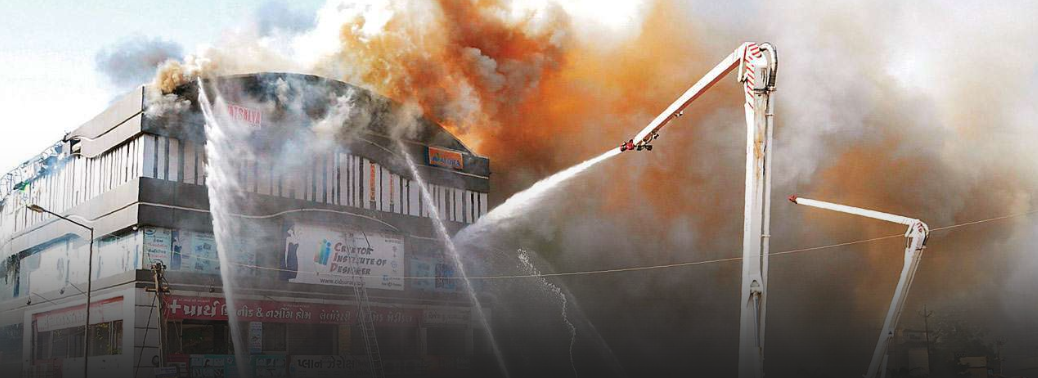
Why in News:
- Shaken out of apathy by the devastating fire at an illegal structure in Surat that claimed the life of 22 students, the Gujarat government asked builders to equip themselves with fire safety installations within three days or face closure.
Details:
- At least 50 properties in Surat had been sealed for violations of fire safety norms.
- As many as 1,123 properties in the city have been issued notices for not adhering to fire safety norms. As many as 22 students studying at an arts coaching in Surat’s Sarthana area lost their lives in the huge fire. The building did not have a no-objection certificate from the Fire Department
Fire safety:
- India’s abysmal record on fire safety is reflected in the death of 17,700 people countrywide in fires in both public and residential buildings during 2015, according to the latest available data from the National Crime Records Bureau. High -profile cases such as the Uphaar cinema blaze in Delhi that killed 59 people in 1997, and the Kumbakonam school fire in Tamil Nadu in 2004 in which 94 children perished shock the nation, but even these are not strong enough to persuade governments to make fire safety the priority it should be. It is essential for the judiciary to send out the message that there will be no tolerance to corruption and evasion in the enforcement of building rules and fire safety. Beyond suspending a few officials and filing cases against the building owners, there is a need to make an example of sanctioning and enforcement authorities. The unwavering message must be that Indians demand accountability. Mandating compulsory insurance for all public buildings against fire risk and public liability can bring about a change to the way architects and builders approach the question of safety, since the insurer would require a reduction of risk and compliance with building plans.
Long wait for power in Odisha after Cyclone Fani snaps transmission lines
10, May 2019
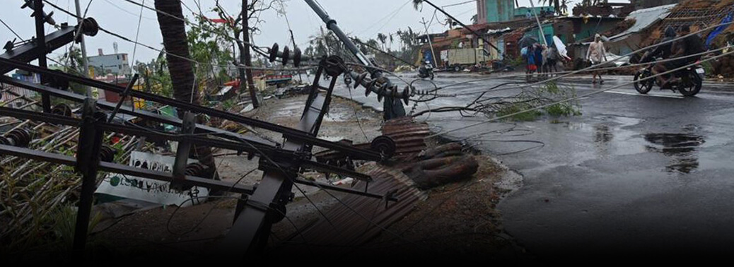
Why in news:
- Hot and humid weather has compounded the woes of the cyclone-affected people in Odisha, with the government facing a gigantic task of restoring power to houses in Puri and Khurdha districts battered by Fani. massive efforts is taken by the State government for total power restoration in Bhubaneswar.
Details:
- The extremely severe cyclonic storm ‘Fani’ has damaged 75 high power transmission towers while 84,000 km low tension power lines have been found either broken or sagging. Over 11,000 distribution transformers were damaged.
- Two lakh electric poles have been damaged by the cyclone.
- The Steel Authority of India Limited has made a commitment to provide 60,000 poles in phases while 30,000 poles have to be procured from different manufacturers in the State.
Background:
- A powerful cyclonic storm named Fani is headed towards the Odisha coast.
- As a cyclone in Bay of Bengal in April-May season, of this nature, is unusual, it is essential to understand the causes.
How do tropical cyclones form?
- Cyclones are formed over slightly warm ocean waters.
- It depends on the temperature of the top layer of the sea, up to a depth of about 60 metres.
- This has to be at least 28°C to support the formation of a cyclone.
- This explains why the April-May and October-December periods are conducive for cyclones.
- Secondly, the low level of air above the waters needs to have an ‘anticlockwise’ rotation in the northern hemisphere and vice versa.
- During these periods, there lies the Inter-Tropical Convergence Zone (ITCZ) (a low pressure zone) in the Bay of Bengal region, which shifts with seasons.
- The southern boundary of the zone experiences winds from west to east and the northern boundary from east to west.
- The ITCZ and the resultant wind pattern induce the anticlockwise rotation of air.
- Once formed, cyclones in this area usually move northwest.
- As it travels over the sea, the cyclone gathers more moist air from the warm sea, and adds to its strength.
How prevalent are tropical cyclones in India?
- Cyclones are a normal event in the eastern coast of India.
- On an average, five to six significant cyclonic storms emerge in the Bay of Bengal region every year.
- The prime seasons for tropical cyclones arethe months of
- April and May, just before the start of the summer monsoon
- October to December, immediately after the end of the summer monsoon
- Cyclones emerging in April-May are usually much weaker than those during October-December.
- Most of the cyclones in April-May move northeast to hit Bangladesh, Myanmar or other countries in the Southeast Asian region.
- There have been only 14 instances of a “severe cyclone” forming in the Bay of Bengal region in April since 1891.
Why are Oct-Dec cyclones more strong?
- A thumb rule for cyclones is that the more time they spend over the seas, the stronger they become.
- [E.g. Hurricanes around the US, which originate in the vast open Pacific Ocean
- They are usually much stronger than the tropical cyclones in the Bay of Bengal, a relatively narrow and enclosed region.]
- In India, cyclones in October-December are usually remnants of cyclonic systems that emerge in the Pacific Ocean.
- They manage to come to the Bay of Bengal, considerably weakened after crossing the Southeast Asian landmass near the South China Sea.
- However, these systems already have some energy, and gather momentum as they traverse over the Bay of Bengal.
- Notably, April-May is not the season for typhoons in the west Pacific Ocean.
- Most of the typhoons, in northern hemisphere, form between June and November.
- So cyclones in April-May originate in situ in the Bay of Bengal itself.
- This is barely a few hundred kilometres from the Indian landmass, and hence the cyclones are relatively weaker.
How and why is Fani different?
- Tropical cyclones in the Bay of Bengal are graded according to maximum wind speeds at their centre as follows:
- depressions – 30 to 60 km per hour (kph)
- cyclonic storms – 61 to 88 kph
- severe cyclonic storms – 89 to 117 kph
- very severe cyclonic storms – 118 to 166 kph
- extremely severe cyclonic storms – 167 to 221 kph
- super cyclones – 222 kph or higher
- Fani is now categorised as an “extremely severe cyclone”.
- It is expected to generate storms with wind speeds as high as 200 km per hour.
- It has the potential to cause widespread damage in Odisha and neighbouring states.
- Given the above discussed reasons, a cyclone of this nature is unusual for April-May cyclones in India.
- Fani is different mainly on account of its place of origin, and the route it has taken.
- Origin – The in situ cyclonic systems in the Bay of Bengal usually originate around latitude 10° N (in line with Chennai).
- Route – Fani was initially headed north-westwards, towards the Tamil Nadu coast.
- But it changed its course midway and moved northeast away from the coastline to reach Odisha.
- The recurve it has taken gave it more time over the sea and has ensured that it has gathered unusual strength.
NEED TO ADDRESS GROWTH CHALLENGES
19, Apr 2019

Why in News:
- Reserve Bank of India (RBI) Governor Shaktikanta Das highlighted the need to address growth challenges as the inflation outlook remained benign, at the meeting of the monetary policy committee
Background:
- Four out of six MPC members had voted for a reduction in interest rate from 6.25% to 6% during the first bimonthly policy review of 2019-20.
- In the previous policy review in February too, the RBI had cut the interest rate by 25 basis points (bps).
- Inflation excluding food and fuel remains uncomfortably close to 5.5%, i.e., at elevated levels through most of the past 12 months
Monetary Policy in India
- Monetary policy refers to the use of instruments under the control of the central bank to regulate the availability, cost and use of money and credit.
What are the goals?
Price Stability along with growth
- The agreement on Monetary Policy Framework between the Government and the Reserve Bank of India in 2015 defines the price stability objective explicitly in terms of the target for i.e., (a) below 6 per cent by January 2016 (b) 4 per cent (+/-) 2 per cent for the financial year 2016-17 and all subsequent years.
Instruments Cash Reserve Ratio (CRR)
- The share of net demand and time liabilities (deposits) that banks must maintain as cash balance with the Reserve Bank.
Statutory Liquidity Ratio (SLR)
- The share of net demand and time liabilities (deposits) that banks must maintain in safe and liquid assets, such as, government securities, cash and gold. Changes in SLR often influence the availability of resources in the banking system for lending to the private sector. Refinance facilities Sector-specific refinance facilities aim at achieving sector specific objectives through provision of liquidity at a cost linked to the policy repo rate. The Reserve Bank has, however, been progressively de-emphasising sector specific policies as they interfere with the transmission mechanism.
Liquidity Adjustment Facility (LAF)
- Consists of overnight and term repo/reverse repo auctions. Progressively, the Reserve Bank has increased the proportion of liquidity injected in the LAF through term-repos.
Term Repos
- Since October 2013, the Reserve Bank has introduced term repos, to inject liquidity over a period that is longer than overnight. The aim of term repo is to help develop inter-bank money market, which in turn can set market-based benchmarks for pricing of loans and deposits, and through that improve transmission of monetary policy.
Marginal Standing Facility (MSF)
A facility under which scheduled commercial banks can borrow additional amount of overnight money from the Reserve Bank by dipping into their SLR portfolio up to a limit (currently two per cent of their net demand and time liabilities deposits) at a penal rate of interest (currently 100 basis points above the repo rate). This provides a safety valve against unanticipated liquidity shocks to the banking system. MSF rate and reverse repo rate determine the corridor for the daily movement in short term money market interest rates.
Open Market Operations (OMOs)
These include both, outright purchase/sale of government securities (for injection/absorption of liquidity)
Bank Rate
- It is the rate at which the Reserve Bank is ready to buy or rediscount bills of exchange or other commercial papers. This rate has been aligned to the MSF rate and, therefore, changes automatically as and when the MSF rate changes alongside policy repo rate changes.
Market Stabilisation Scheme (MSS)
- This instrument for monetary management was introduced in 2004. Surplus liquidity of a more enduring nature arising from large capital inflows is absorbed through sale of short- dated government securities and treasury bills. The mobilised cash is held in a separate government account with the Reserve Bank. The instrument thus has features of both, SLR and CRR.
Monetary Policy Committee
- A new monetary policy committee has been established that will decide on the interest rates. What happened till now – The Reserve Bank’s Monetary Policy Department (MPD) used to assist the Governor in formulating the monetary policy What has changed –Now, the Monetary Policy Committee will be the authority responsible to: Fix the benchmark interest rate of the RBI. Set the inflation targets
Proposed Composition
- It will be a six-member panel, which will include three nominees of the government and three members of the Reserve Bank including the Governor Each member shall have one vote and in case of a tie, the Governor shall have a casting vote. Please note that the governor does not have a veto.
Tenure:
- Members of the MPC will be appointed for a period of four years and shall not be eligible for reappointment. RBI will every six months publish Monetary Policy Report explaining the sources of inflation and the forecasts of inflation for the period between six to 18 months. If RBI fails to meet the inflation target, it shall in the report give reasons for failure, remedial actions as well as estimated time within which the inflation target shall be achieved. With the introduction of the monetary policy committee, the RBI will follow a system similar to the one followed by most global central banks.
Inflation Targeting
- Inflation targeting is a central banking policy that aims to meet the present targets for the annual rate of inflation What were Urijit Patel committee’s recommendations? The Reserve Bank of India (RBI) had constituted an Expert Committee to Revise and Strengthen the Monetary Policy Framework under the Chairmanship of Dr. Urjit Patel. The committee submitted its report in January 2014.
Important recommendations made were:
- Inflation should be the nominal anchor for the monetary policy framework. This nominal anchor should be set by the Reserve Bank as its predominant objective of monetary policy in its policy statements
- The RBI should adopt the new CPI (combined) as the measure of the nominal anchor for policy communication
- the target for inflation should be set at 4 per cent with a band of +/- 2 per cent around it
- In view of the elevated level of current CPI inflation and hardened inflation expectations, supply constraints and weak output performance, the transition path to the target zone should be graduated to bringing down inflation from the current level of 10 per cent to 8 per cent over a period not exceeding the next 12 months and to 6 per cent over a period not exceeding the next 24 month period before formally adopting the recommended target of 4 per cent inflation with a band of +/- 2 per cent
- timely monetary policy response to shocks to food and fuel since they account for more than 57 per cent of the CPI
- Monetary policy decision-making should be vested in a monetary policy committee
- The MPC will be accountable for failure to achieve the inflation target of 4 per cent (+/- 2 per cent) for three successive quarters
- dependence on market stabilisation scheme (MSS) and cash management bills (CMBs) may be phased out
Advantages of Inflation Targeting
- Inflation targeting facilitates in predicting inflation It brings in an element of transparency
- It has the ability to maintain price stability and prevent one-time shocks to inflation It brings in element of accountability
- According to International Monetary Fund, in emerging markets, “Inflation Targeting appears to have been associated with lower inflation, lower inflation expectations and lower inflation volatility relative to countries that have not adopted it
Criticism for Inflation Targeting
- Inflation target reduces “flexibility” As Donald Kohn, noted American economist stated “Placing any number on an inflation objective – however much it would be surrounded with caveats – has the potential to constrain policy in some circumstances in which it would not be desirable to do so.”
Seismometer In Maharashtra
04, Mar 2019

In News
- The National Centre of Seismology (NCS) and India Meteorological Department (IMD) decided to have another seismometer would be installed in Palghar district, taking the total number of such monitors to four.
About:
- The National Centre for Seismology (NCS) under the Ministry of Earth Sciences and the CSIR laboratory National Geophysical Research Institute (NGRI), Hyderabad, have set up 5 stations with seismometers in Dahanu and Talasari to identify the source of the earthquakes and understand their cause.
- It is on the event of two earthquakes rocked Mahrashtra in quick succession three days before.
- According to officials from IMD, the fourth instrument to be located east of the last earthquake’s epicentre will enable the team in acquiring a more accurate data.
- Palghar district has seen thousands of small earthquakes since November 2018, but the March 1 quake measuring 4.3 on the moment magnitude (Mw) scale was the first time the magnitude crossed 4 here
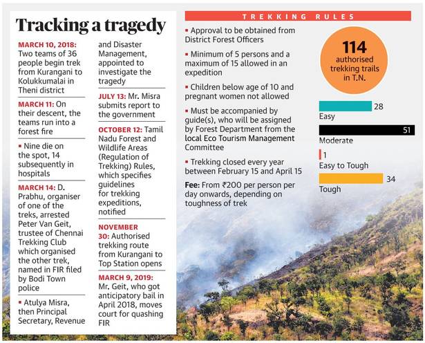
When the hills fall silent
10, Jan 2019

- A year ago, Kurangani, a village in the district of Theni, was teeming with people from cities like Chennai and Bengaluru, seeking adventure. They would scale the Othamaram, Kolukkumalai and Top Station with the help of locals, to camp and trek on weekends.
- The treks, largely unauthorised, created a small, yet thriving local economy by providing livelihood and supplementary income to many families in Kurangani and nearby hamlets. That is history now. Life for villagers changed after March 11, 2018, when 23 people were killed in a forest fire. After the fire, everything abruptly ended.
- The 23 victims were from two groups of trekkers, of which only one had engaged a local guide. While some escaped, 17 women and six men, who were descending from Othamaram, got caught in the blaze.
13 Feared Dead in Meghalaya Coal Mine
15, Dec 2018
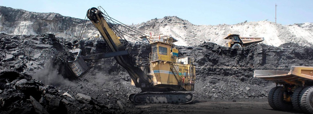
Context:
- At least 13 miners are feared dead in a coal mine accident in Meghalaya’s East Jaintia Hills district on Thursday.
Details:
- District police officials said the miners were trapped inside the coal mine after they accidentally cut through an adjoining abandoned mine filled with water.
- The National Green Tribunal has banned unscientific and unsafe rat-hole coal mining in Meghalaya since 2014. A case has been registered against unknown people for their involvement in the illegal mining of coal.
Few more details on coal mine deaths:
- India has good safety record in open-cast mining, but when it comes to underground mining, safety record is extremely poor
- There are also questions about the validity of Indian numbers given the large number of illegal wildcat mines where accidents, let alone fatalities, never make it to the official statistics
- It has among the highest rates of fatalities and injuries in the coal industry from the collapse of roofs and walls in the world.
- India also has unusually high incidents of accidents caused by the surface movement of heavy machinery – strictly speaking not even a consequence of actual mining activity but a clear sign of administrative failings.
- Miners are also exposed to a number of hazards that adversely affect their health, including dust, noise, heat and humidity.
- The problem of inadequate compensation is another debilitating factor
About National Green tribunal:
- The National Green Tribunal has been established on 18.10.2010 under the National Green Tribunal Act 2010 for effective and expeditious disposal of cases relating to environmental protection and conservation of forests and other natural resources.
- The responsibilities also include enforcement of any legal right relating to environment and giving relief and compensation for damages to persons and property and for matters connected therewith or incidental thereto.
- It is a specialized body equipped with the necessary expertise to handle environmental disputes involving multi-disciplinary issues.
- The Tribunal is not bound by the procedure laid down under the Code of Civil Procedure, 1908, is guided by principles of natural justice.
- The Tribunal’s dedicated jurisdiction in environmental matters shall provide speedy environmental justice and help reduce the burden of litigation in the higher courts
- The Tribunal is mandated to make and endeavor for disposal of applications or appeals finally within 6 months of filing of the same.
Study – Cyclone Forecast
20, Oct 2018
- Weather observations in the Arctic can help track tropical and mid-latitude cyclones more accurately, improving the forecast of extreme climate events found research.
About:
- The data were analysed using a data assimilation system developed in Japan Agency for Marine-Earth Science and Technology, which can produce reanalysis datasets by “mixing” observations into global atmospheric conditions.
- Upper-level observations such as radiosondes in the Arctic can help to forecast mid-latitude extreme events. Impacts of the Arctic observations can transfer through the tropospheric polar vortex, which is massive low-pressure air mass over the Arctic or Antarctic regions at about 10-km altitude.
- The tropospheric polar vortex, sometimes, extends toward mid-latitudes accompanied with the meandering of mid-latitude westerly jets. This extension can occur even in summer, that is, in August-September, where the meandering and extension were relatively active among the recent years. Thus, the impacts of the Arctic radiosonde observations could influence the mid-latitude extremes, the courses of three tropical cyclones approaching to Japan or Northern US and Greenland, since the impacts transferred through the extended tropospheric polar vortex.
Significance:
- Hurricanes and typhoons are one of the most influential phenomena for human life. Precise weather forecast is critical to enable communities to adequately prepare for weather disasters.
- Currently, meteorological observations are conducted by radiosonde, a weather instrument that records meteorological data, typically released into the atmosphere with a weather balloon.
- Due to hostile conditions experienced in the Arctic and the limited reach of the low-pressure system, the number and frequency of these observations are limited.
- There are gaps in the data that result in weather forecasts being less accurate than what they could and should be, potentially putting peoples’ lives at risk.
- Precise weather forecast is critical to enable communities to adequately prepare for weather disasters. As extreme weather events have been frequently observed in all seasons all over the world, Hurricanes and typhoons are one of the most influential phenomena for human life. The observations improved the predictability of the cyclones, allowing the scientists to track the paths of the cyclones as well as forecast their intensity more accurately.
- This study demonstrated the usefulness of additional Arctic observations for mid-latitude numerical weather forecasts for tropical cyclones.
Cyclone – TILTI
15, Oct 2018
In News:
- Odisha, Andhra on red alert as cyclone Titli inches close
- Severe Cyclonic Storm ‘TITLI’ over west central Bay of Bengal:
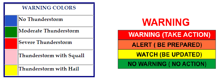
Tropical cyclone:
- A tropical cyclone is the generic term for a non-frontal synoptic scale low-pressure system over tropical or sub-tropical waters with organized convection (i.e. thunderstorm activity) and definite cyclonic surface wind circulation.
- Tropical Cyclone is a common name; the regional varies as Hurricane in the Atlantic, Typhoon in the Pacific and Cyclone in the Indian Ocean.
Difference between tropical cyclone and temperate cyclone
- LATITUDE: Tropical cyclone is confined between 5 to 30 degree north and south of the equator, whereas temperate cyclone originates between 30 to 60 degree north and south of the equator
- ORIGINATING ELEMENT: Temperature and Coriolis force plays vital role in the origin of tropical cyclone. In case of temperate cyclone, it is frontogenesis plays important driving force (occluded front).
- TYPES OF CLOUD ASSOCIATED: Wide range of clouds is associated with the temperate cyclone. While in the case of tropical cyclone the cloud composition is mainly dominated by clumonimbus clouds.
- AREA COVERED: Temperate cyclone covers large area as compared to tropical cyclone.
- SOURCE OF ORIGIN: Tropical cyclone generally originates over water surface but the temperate cyclone originates over mid-latitude land mass.
- DIRECTION OF FLOW: Temperate cyclone generally flows eastward movement (west -> east) but there is no as such fixed movement pattern in case of tropical cyclone. Tropical cyclone generally takes the path from sea to land.
- NUMBERS: Tropical cyclone is of singular characteristic, whereas temperate cyclone flows in family.
- EYE: Eye is a typical feature in case of tropical cyclone, where as in temperate cyclone there is no such concept of ‘EYE’ associated with it.
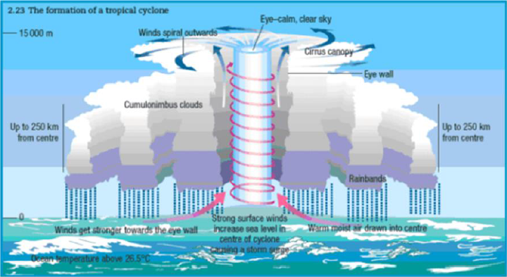
Benefits of Tropical Cyclones:
- Although Tropical cyclones are known for destruction they cause, when they strike they also bestow certain benefits to the climatic conditions of that area such as
- Relieve drought conditions.
- Carry heat and energy away from the tropics and transport it towards temperate latitudes, thus helps to maintain equilibrium in the Earth’s troposphere and
- Maintain a relatively stable and warm temperature worldwide.
Centre increases in share
06, Oct 2018

Why in News?
- The Centre has enhanced its contribution in the State Disaster Response Fund (SDRF) from 75 per cent to 90 per cent with effect from April, the Ministry of Home Affairs announced. As per revised guidelines, the Centre will contribute 90 per cent while states will contribute 10 per cent to the relief fund.
About the News:
- The additional contribution by the central government in SDRF on this account will be Rs 1,690.35 crore for 2018-19 and Rs 1,774.67 crore for the financial year 2019-20.
- Under the Disaster Management Act 2005, a financial mechanism has been set up by way of National Disaster Response Fund (NDRF) at the national level and SDRF at the state level to meet the rescue and relief expenditure of disaster-affected states
- The SDRF has been constituted in each state in which the Centre, till date, has been contributing 75 per cent to states belonging to the general category and 90 per cent to those belonging to the special category, such as the hilly regions, the statement read. At any point, each state government has a fair amount of funds available under the SDRF.
- In case of any natural calamity beyond the coping capacity of a state, additional financial assistance, as per norms, is provided by the central government from NDRF, in which 100 per cent funding is by the central government.
- Based on the recommendations of successive Finance Commission, the Centre approves the annual allocation to SDRF. On the recommendations of 14th Finance Commission, the government has significantly enhanced the allocation to SDRF by 82.30 per cent i.e. from Rs 33,580.93 crore during 2010-11 to 2014-15 to Rs 61,220 crore for 2015-16 to 2019-20.
- In addition, the central government has provided additional financial assistance of Rs 32,142 crore from NDRF to the states during 2014-2018 compared to Rs 14,098 crore provided during 2010-2014, which is also significantly higher.
NDRF:
- National Disaster Response Fund is defined in Section 46 of the Disaster Management Act, 2005 (DM Act) as a fund managed by the Central Government for meeting the expenses for emergency response, relief and rehabilitation due to any threatening disaster situation or disaster.
- NDRF is constituted to supplement the funds of the State Disaster Response Funds (SDRF) of the states to facilitate immediate relief in case of calamities of a severe nature.
C-FLOWS, (Chennai Flood Warning System)
05, Oct 2018
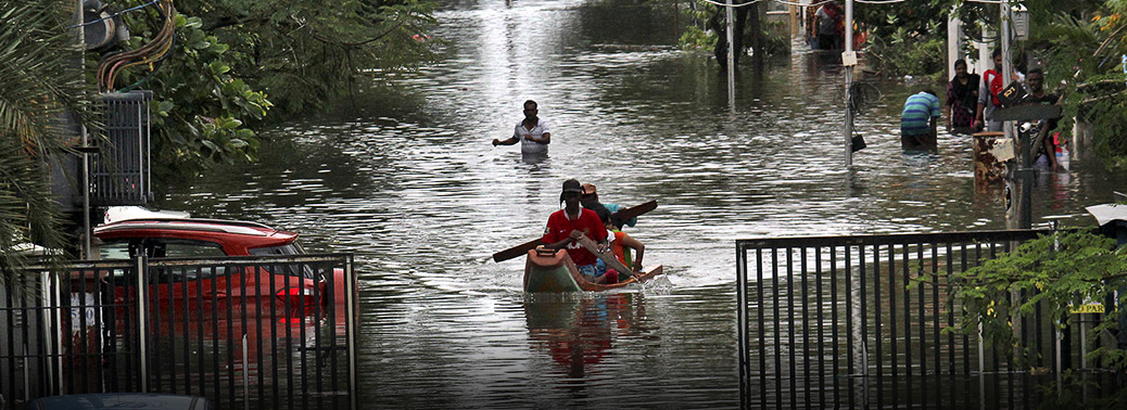
In news:
- The office of the Principal Scientific Advisor to government of India, research institutions, chief among them the National Centre for Coastal Research (NCCR), Chennai, and IITs, got together to build a flood warning system customized for use in Chennai.
- Carrying the acronym CFLOWS, which stands for Chennai FLOOD Warning System.
Background:
- The six-module ensemble can predict flooding due to heavy rainfall, sea level rise and increase in water levels of the three rivers (Cooum, Adyar and Kosasthalaiyar) that traverse the city. The State government shared data such as ward boundaries, population details, infrastructure available across Tamil Nadu, which have been used in the warning system. Knowing the elevation at different spots, the system can predict the way the area would flood based on different scenarios that have been simulated. Inputs were taken from the India Meteorological Department (IMD) on forecast and National Centre for Medium Range Weather Forecasting (NCMRWF), which gives the prediction for rain 10 days in advance.
- Similarly, INCOIS gives the hydrodynamic congestion such as storm surge and tide etc. Using this, the system can, two weeks ahead of the event, simulate the scenario. The system can predict what would happen at the level of individual wards
- The flood itself cannot be avoided, but it can be managed and the disaster mitigated, if this kind of module are properly utilized.
Catastrophe Bond
22, Aug 2018
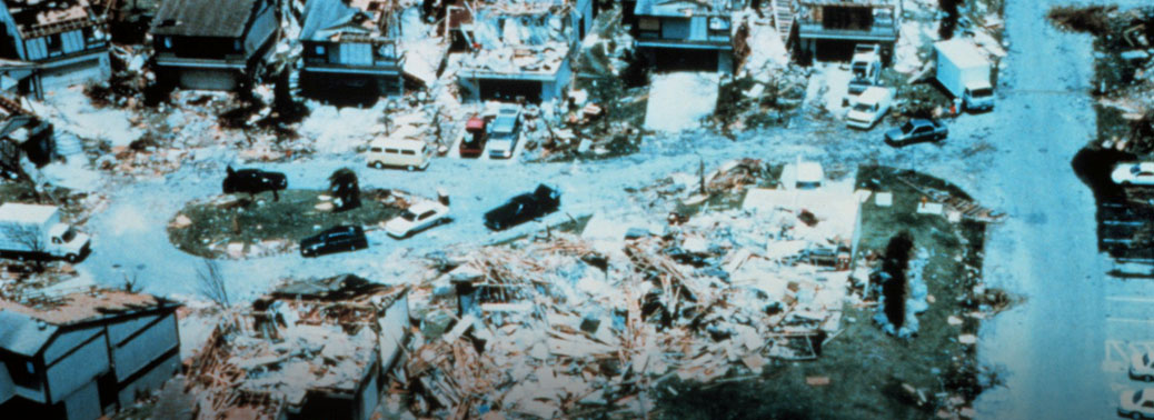
- The recent floods in Kerala have set off a debate need of catastrophe bond in India.
- Considering that only about 30% of the damage from natural disasters are insured, such losses can impose severe financial burden on governments. In developing countries, governments may have to divert state funds, including those earmarked for development projects, to disaster relief and rebuilding efforts.
About:
- Catastrophe bonds, also called cat bonds, are an example of insurance securitization to create risk-linked securities which transfer a specific set of risks (generally catastrophe and natural disaster risks) from an issuer or sponsor to investors.
- This is a market mechanism for providing relief to the people in a timely manner. The catastrophe risk could be securitised and that it could be dispersed among a wide number of investors.
Significance:
- Meant to raise money in case of a catastrophe such as a hurricane or earthquake. Catastrophe bonds are used by property/casualty insurers and reinsurers to transfer risk to investors.
- The cost of issuing and managing catastrophe bonds is cheaper than the cost of reinsuring these risks and does the same function of transferring risk. Hence, insurance companies prefer issuing catastrophe bonds.
- The investors are compensated by a rate of return which is higher than that of normal government or corporate bonds.
- The advantages of the bond is diversifying the risk and reduces the stress on the balance sheets of the governments at the State and the Centre.
- This is perhaps the only class of bonds that is not tied to economic performance parameters which would be the case in equity. The world over the size of the catastrophe bond market is more than $30 billion.
- Catastrophe bonds are issued by insurance companies which have exposure to property and calamity insurance. In catastrophe bonds insurance industry hedge their risks through collaboration with capital markets companies.
- The instrument is a bond where the investor loses a part or whole of the capital based on certain pre-agreed conditions being triggered.
- The SPV invests the money from investors and pay coupons or interests to them. At the end of the term, the SPV will return the investors’ money if a disaster does not happen.
- It is high time that such instruments are introduced in India so that relief and reconstruction work in areas affected by natural disasters goes on unimpeded and are no stalled for only want of capital.


